Triple Divide Peak and Lion Rock are two mountains on the Sierra Club’s Sierra Peaks Section (SPS) list, located on the Great Western Divide in Sequoia National Park. Craig invited me to join him, Daryn, and Kathy on a weekend trip to bag these two infrequently climbed peaks and of course I accepted! Craig and I carpooled up to Sequoia National Park and slept in the parking lot. It was a lovely, cool night but I didn’t get much sleep past 2 AM because a black bear decided to forage nearby. We met Daryn and Kathy in the morning to pick up our permits.
Trip Planning
Specs: 36.5 mi | +/- 9400 ft | 2.5 days, 2 nights
Difficulty: Class 3 to Triple Divide Peak and class 3 – 4 to and from Lion Rock [learn more]
Location: Sequoia National Park, California | Home of the Eastern Mono/Monache, the Western Mono/Monache, and the Tübatulabal peoples | View on Map
Route Summaries
Approach: The hike to Tamarack Lake begins on the High Sierra Trail. About 10.4 miles down the trail, just before reaching the Bearpaw Meadow ranger station, take the “Over The Hill Trail” to the lower end of Lone Pine Meadow. Finally, follow the trail up to Tamarack Lake.
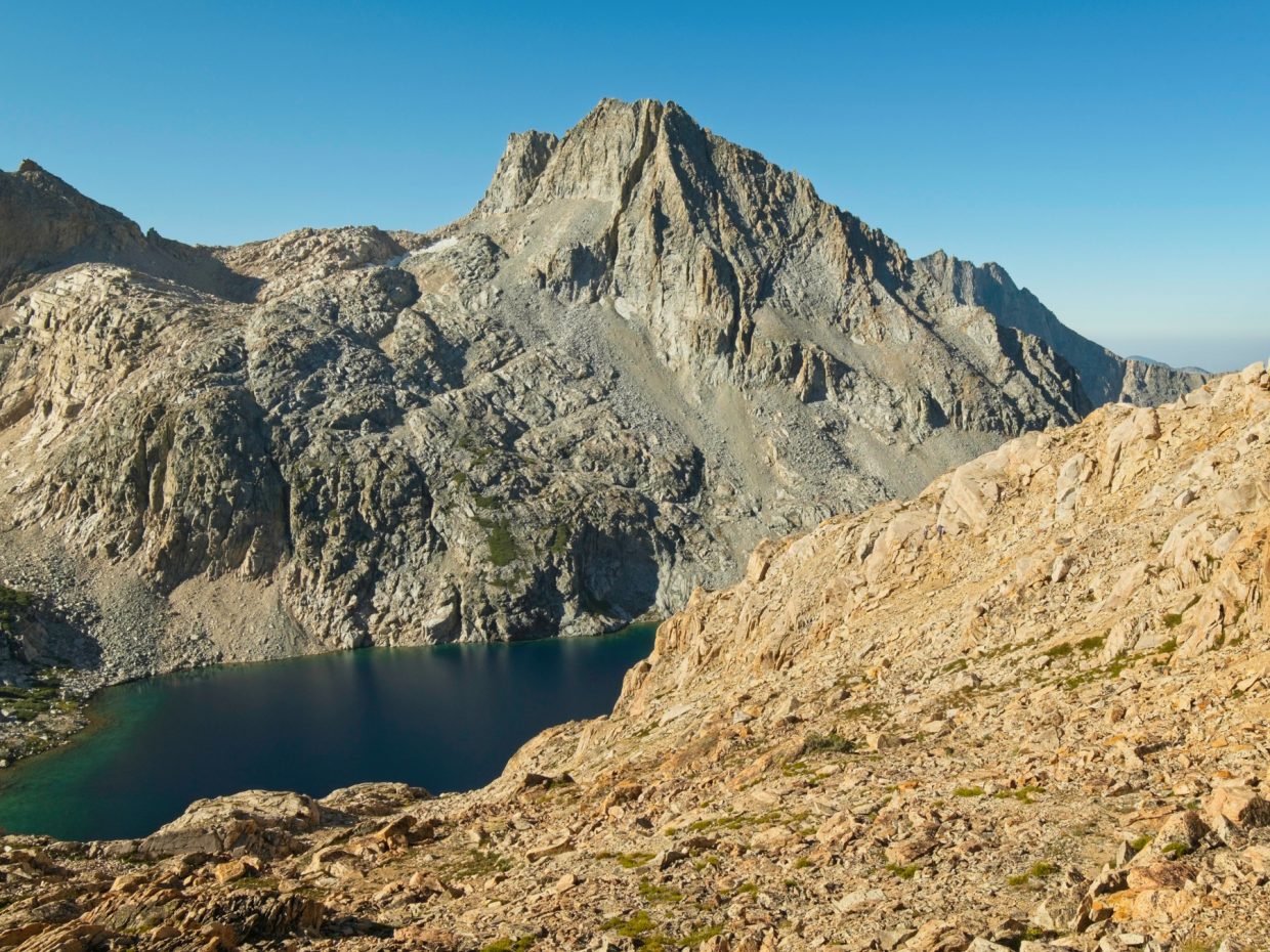
Triple Divide Peak [West Ridge]: Begin by scrambling up the headwall above Tamarack Lake. There is a weakness in the cliff just west of the inlet waterfall; you can follow a use trail from foot of the lake. Once atop the cliff, contour around the north side of the large meadow and make your way up the next headwall. There are many routes up these banded cliffs; stay to the right (south) of the Lion Lake outlet for the most stable terrain. Contour around the north side of Lion Lake, gradually ascending to Lion Lake Pass, the obvious saddle directly north of Lion Lake. From the pass, follow the ridge to the summit. A few cairns mark the easiest route for the first few hundred yards, which drops down a bit from the ridge on the left (north) side. You can remain below the ridge for some easy class 2 talus scrambling (though it can be quite loose) or climb back up to the ridge for more solid, though more exposed, class 3 terrain.
Lion Rock Ascent: [Northeast Chute]: There appears to be a passable network of chutes and benches from Lion Lake up to the east side of Lion Rock, but we didn’t climb that way. Coming from Lion Lake Pass, we contoured around the east side of the lake, ending up at the tarn between Triple Divide and Lion Rock. A convenient ramp of granite slabs provides access to the talus fields just below the peak; alternatively, a chute on climber’s left of the ramp also leads to the top. The “Northeast Chute” is very obvious when approached from this direction: it cuts diagonally to a notch between the two peaks on Lion Rock, is full of dark rock, and is overshadowed by towering cliffs. Secor’s route description says to scramble halfway up this chute and then climb the southeast face. We didn’t like the look of that route at all – the southeast face is class 4 or easy 5th class climbing with plenty of exposure. Instead, scramble all the way up the chute. I felt comfortable scrambling up the chute, but I would say it is class 4 due to the looseness and steep angle. Be very careful here as rocks can pick up a lot of speed and hit climbers below! From the top of the chute scramble up the class 3 terrain north of the notch to the summit.
Lion Rock Descent [West Face]: It’s difficult to describe the exact route, but you begin by heading north from the summit for 10 – 20 feet until you can drop into a chute below. Navigate down class 3 slabs, occasionally crossing a rib while keeping an eye on the terrain to skier’s right as it provides easier passage to the lower-angle slabs and talus below. You’ll eventually reach a vast talus field that leads down to the headwall above the meadow. We contoured around the to the west, eventually dropping down to the meadow. Cairns northwest of the Tamarack Lake inlet creek lead to the cliff weakness that provides access back to the lake.
Permits & Regulations: A backcountry permit is required for all overnight trips in Sequoia National Park. The park’s backcountry regulations are pretty standard: pack out your trash and toilet paper, bury waste away from water and trails, etc. Bear-proof food storage containers are also required.
Resources: I recommend the Sequoia and Kings Canyon National Geographic map for trips in this area. Also, check out the Sequoia National Park page on overnight backpacking for a wealth of information.
The High Sierra Trail
6 Aug, 2021 | 15 mi | +3600 / -1000* ft | View on Map
*estimates; mapping software does a poor job of measuring the elevation change on this trail
It took about an hour to get our permit this morning. There was a group lecture about leave-no-trace ethics, then a long wait in line as each party chatted with the ranger issuing the permits. But now we’re on our way, strolling down a paved trail under the canopy of giants. We saw the Sentinel Tree this morning, a 2,200-year-old sequoia with a diameter of about 25 feet. There are a few stands of sequoias sprinkled throughout the forest, all of them massive. Maybe there are small ones too, but I don’t know how to identify them besides their size!


We spend all of the morning and a little of the afternoon hiking along the High Sierra Trail (HST) to Bearpaw Meadow. We meet several groups that are hiking the HST all the way to Mount Whitney, a 72-mile journey. This beginning portion is pretty easy hiking: mostly flat as we contour along the northern wall of the canyon and shaded beneath all of the lush pine trees. This is not the kind of hike you get on the east side of the Sierra! A highlight of the morning is a small family of black bears foraging in the brush above the trail. We pause for a minute to watch them and then continue on.


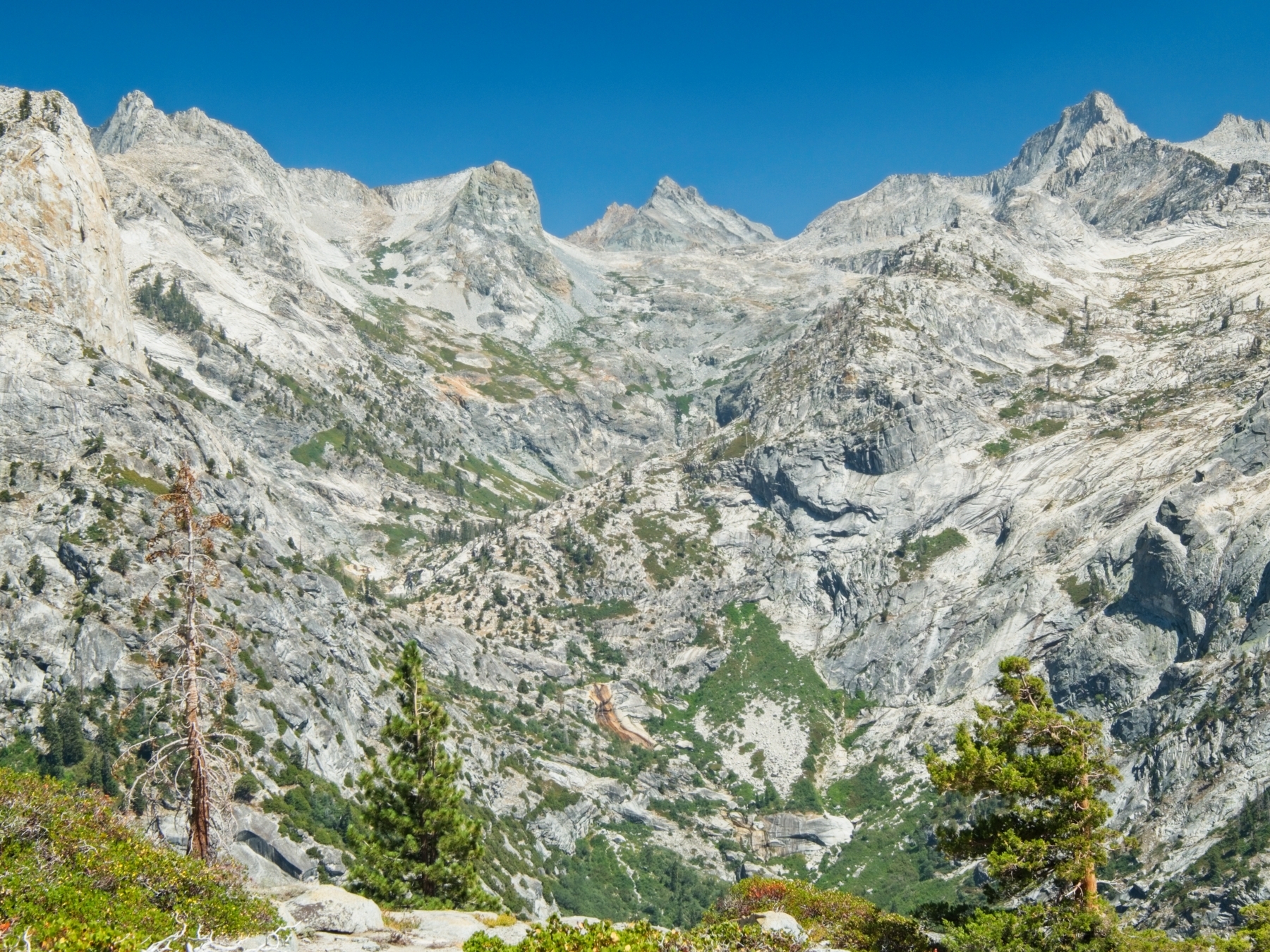
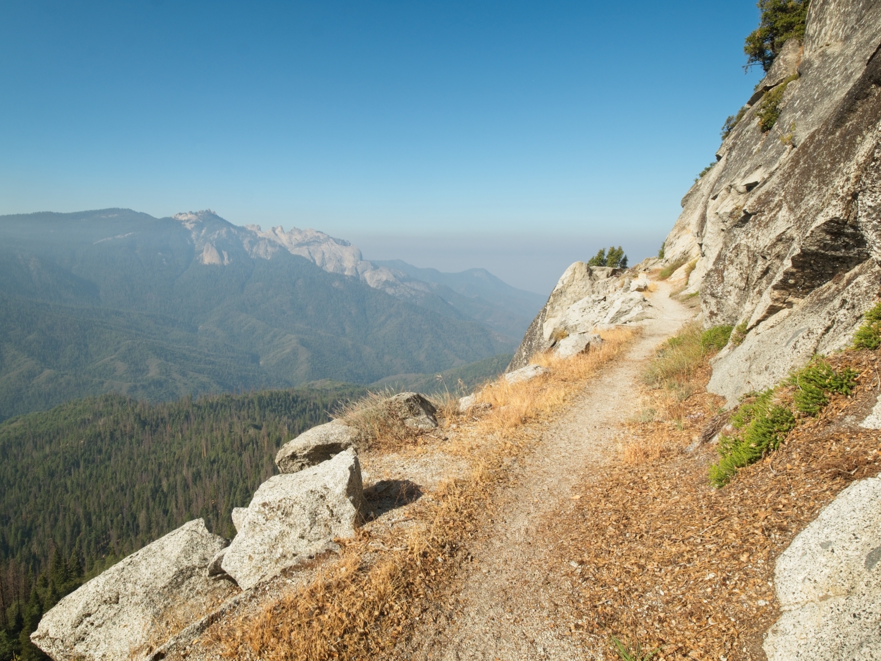
The easy hiking ends just before Bearpaw Meadow when the trail descends to Buck Creek and then climbs 600 feet. It’s not a particularly cool day, so I’m sweaty and breathing heavily by the time I reach the top of the hill at 13:00. I find Craig relaxing on a log in the shade where I plop down and eat my lunch while we wait to regroup with Daryn and Kathy. It turns out that they stopped earlier to rest and eat, but they’re not too far behind us. Craig and I make a quick detour to the ranger station to fill up water bottles and then join Daryn and Kathy on the “Over the Hill Trail,” an alternate path to the High Sierra Trail that cuts a few tenths of a mile from our trek. This alternate trail proves to be super dusty, loose, and steep. I struggle through the uphills knowing that sooner or later we’ll top out and get to descend for a while. When we do eventually reach the top of “the hill,” we’re rewarded with an incredible view the Great Western Divide. The topo map labels the canyon before us “Valhalla,” which seems like a fittingly grand name for a landscape of shining white granite.
The descent down the other side of the hill turns out to be less steep and much more enjoyable than the ascent. We contour along the side of the valley, looking down on the High Sierra Trail carved into granite cliffs on the opposite side of the valley. A short while later, we arrive at Lone Pine Creek. Kathy and Daryn decide to take a break at the water but Craig and I continue on. I’m already dreaming of a nice, cool swim in Tamarack Lake, and it’s only a few miles away now!


When we reach the lake, Craig and I meet Ron, a fellow hiker who is planning to climb Triple Divide Peak tomorrow! We chat for a minute or two and then go looking around for a good swimming hole. A beach made entirely of granite slabs catches my eye, but it’s a bit far away from the camping area. Craig and I decide the shore near camp will do just fine and wade on in. The cold water feels amazing after the hot afternoon hike! I swim around for a bit and then just float in the water, perfectly content.
Kathy and Daryn arrive a little later and set up camp nearby. Once they’re settled, we all gather on top of a massive boulder for dinner. I munch on one of my usual backpacking meals, instant mashed potatoes and cheddar cheese, and stare in amazement as Daryn and Kathy pour wine from a plastic bottle and prepare a three-course meal; these people know how to camp!


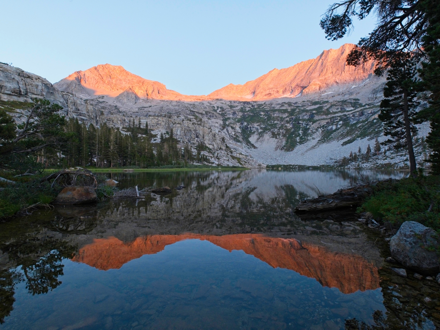
We spend the rest of the evening relaxing. I bundle up in a few layers, not because it’s particularly cold outside but because swimming in the chilly lake cooled me down pretty significantly. The evening alpenglow paints Lion Rock and Mount Spencer pink and the reflections in Tamarack Lake are magnificent! I’m pretty beat so I head to bed once the light begins to fade.
Time to Climb
7 Aug, 2021 | 6.5 mi | +/- 4800 ft | View on Map
Craig, Kathy, Ron, Daryn and I set out this morning for Triple Divide Peak at about 6:15. We cross the the outlet creek of Tamarack Lake and push through some brush on our way to a crumbled crack in the cliffs that surround the lake. After an easy scramble to the top of the cliff, we stroll around a wide meadow full of long grass and willows. It looks soggy, so we keep to the side on higher, rockier ground. Up ahead, another headwall blocks the way forward, but there are plenty of grassy chutes and benches crisscrossing the face. I have fun navigating through this complex terrain even though a few spots are choked with annoyingly thick willows.


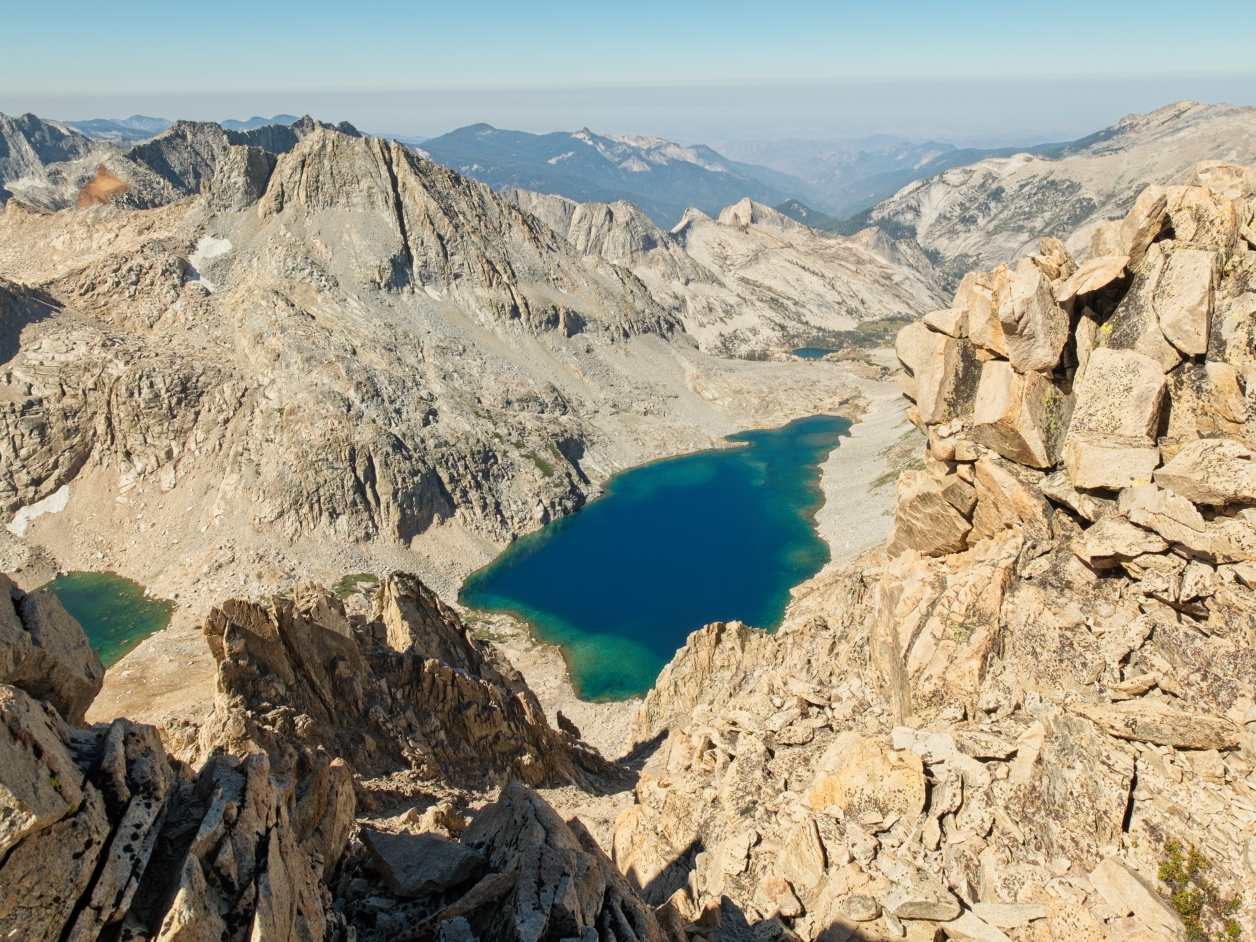
Above the headwall we scramble up talus for a few hundred more feet and then emerge into the bright sunlight just below Lion Lake. The outlet creek seems to be completely subterranean at this point; I can hear the water cascading down the falls behind me but the creek bed below my feet is mostly dry. We pause at the lake for a few minutes to apply sunscreen, gather water, and munch on a snack before we begin the climb to Triple Divide Peak. Ron decides to hang back and take his time (he’s not planning to climb Lion Rock today) and wishes us good luck on the ascent.
After a quick break, Craig, Daryn, Kathy and I set off around the north side of Lion Lake and gradually climb upward toward Lion Lake Pass, an obvious saddle in the west ridge of Triple Divide Peak. The mountainside alternates between solid, grassy slopes and moderately loose scree. The former is a pleasure to walk up, the latter a pain, and we spread out a bit as we settle into our own paces.


We regroup at the Lion Lake Pass and then begin up the west ridge. At first, we stick to the ridge crest but are soon faced with some class 3 climbing to stay on that route. Daryn, who climbed this peak 25 years ago, advises staying to the left (north) side of the ridge where the slope is gentler. A couple of cairns guide us off of the ridge to the northern slopes where we follow a faint, undulating use trail over the ribs of the mountain. The rock seems to become looser and looser as we travel east so Craig and I decide to abandon the mountain side in favor of some solid class 3 climbing up on the ridge crest. It’s a little exposed in a few places, but I enjoy the scrambling there more than sliding around in the loose stuff below.
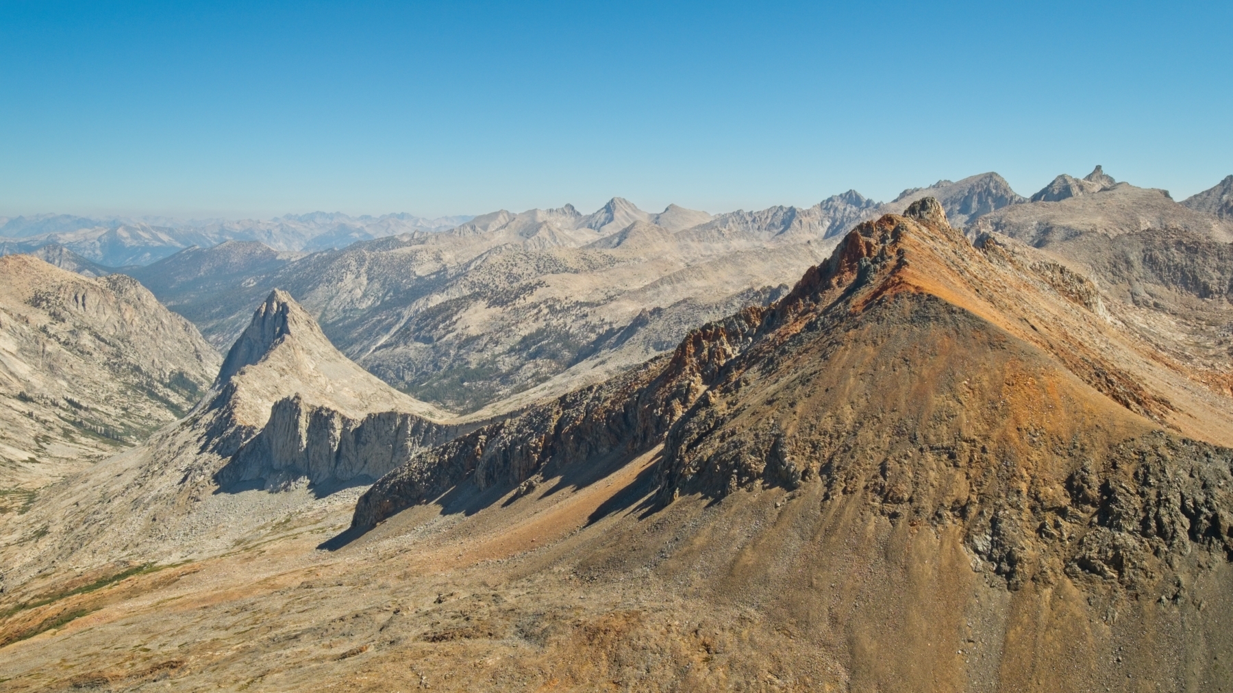
We reach the summit at about 10 AM. It’s not particularly roomy, so we spread out a little on the various blocks and relax for a bit. The summit register dates back to the early 90’s and Daryn finds his signature from 25 years ago! I enjoy gazing out at the mountains, which stretch on for as far as I can see. Mount Whitney‘s serrated ridge stands out to the east, as do Mount Tyndall, Mount Williamson, and even Mount Goddard to the north!


After a nice break, we rouse ourselves and begin the scramble back to Lion Lake Pass. We all descend to the loose, north slope and take care not to send any rocks hurtling down on each other. We pass Ron about halfway down the ridge; he’ll be up to the top in no time! I find the descent a bit tedious, but that’s sort of the name of the game climbing mountains: moderately difficult and very tedious.
From Lion Lake Pass, we decide to contour around the east side of the lake to save ourselves some distance and elevation gain. I don’t mind crossing the sandy slopes too much; they’re soft and easy on the knees, at least. We stop for a lunch break beside a cyan tarn and gaze up at Lion Rock. Somewhere up there is the “northeast chute” which will lead us to the summit. Closer at hand, we inspect the slopes leading up from the tarn. Daryn recognizes a wide chute as a the route he climbed previously, and there’s a nice-looking set of granite slabs just to the right.


Once we’ve finished lunch, we head up onto the slabs. It’s fun climbing with a few, short class 3 sections that I thoroughly enjoy. Higher up the terrain transitions back to talus and then to very, very lose talus. I finish the last hundred feet scrambling on all fours, being very careful (but not entirely successful) to avoid knocking any rocks down on Kathy or Daryn below, finally taking refuge on a small bench below the steep southeast face of Lion Rock.
We’re now at the foot of the chute, which climbs steeply on a diagonal up to a notch below the summit. Secor’s instructions for this route tell us to climb halfway up the chute and then abandon it in favor of the southeast face. Craig heads up to take a look but can’t see an easy way up the face, so he continues scrambling up the chute in search of alternate options. Several rocks come careening down the chute as he scrambles up, so Kathy, Daryn, and I stay to the side to avoid being struck. A few minutes later Craig calls down that he’s reached the top but doesn’t respond when we yell up to ask if we should follow him. Daryn explores around the southeast face a bit while we wait, but I eventually decide to head on up myself.
The chute is both loose and steep, but the walls are solid and I rather enjoy stemming up it. I would not rate this as class 3 climbing, however – it is certainly class 4. Halfway up I try Secor’s route and begin climbing up the face but the holds are small and far apart, much too difficult for my taste, at least without rock shoes. (I’d give the face a hard 4th or easy 5th class rating.) So I carefully downclimb to the chute, just as Craig yells down that there’s a way to the top if we continue all the way up the chute. Encouraged, I scramble to the top with Daryn and Kathy not too far behind. From the top of the chute, we follow a class 3 route directly up the ridge to where Craig is waiting. Once we’ve regrouped, we finish the climb to the top together, arriving at 14:20.


We take a nice long break atop Lion Rock. The summit register is over 63 years old and still in surprisingly good condition! We’ve got an excellent vantage point on the Kaweah Range from here, and Craig, Daryn, and Kathy start naming off all of the peaks we can see. We stall for a while longer, dreading the descent, but eventually head out.


We debate the descent plan for several minutes. There is supposedly a class 2 route through a chute on the southwest side, but Daryn recalls that route being impassible the last time he climbed here. So we begin down the west face instead, intending to cut across to the southwest side when we can. The downclimbing is steep and fairly loose, a frustratingly common occurrence today, and we don’t end up finding a passable route into the southwest chute. We do find a way down the west face, however, and slowly lower ourselves down the class 3 slabs for what feels like a full hour. The slabs eventually give way to talus and then to the solid rock of the headwall that overlooks the meadow we crossed this morning. Rather than bushwhack through a bunch of willows to retrace our steps this morning, I follow Craig across the top of the cliffs to the southwest until we find a way down to the meadow.


We run into Ron just as we reach the far end of the meadow, quite the surprise given how long it’s been since we last saw him! We scramble down the last set of cliffs together and arrive back at the lake around 5:30. Ron, Craig, and I jump into the lake again to cool off, then cook dinner together and chat for the rest of the evening.

Speed Walking
8 Aug, 2021 | 15 mi | +1000 / -3600* ft | View on Map
*estimates; mapping software does a poor job of measuring the elevation change on this trail
I’m up well before dawn this morning. Craig and I want to get home at a reasonable hour, so we begin the hike back the trailhead at 5:45. I enjoy watching the sky transition from black to gray, purple, pink and then blue. The sun just barely illuminates the peaks on the Great Western Divide as we trek back to the High Sierra Trail.


The rest of the walk back to the trailhead passes by in a blur. We stop every two hours or so to eat, rest, and refill water bottles, but otherwise walk as quickly as we can manage. Our efforts pay off: we reach the car at 11:15, just 5.5 hours after leaving camp. Not too shabby for a 15-mile hike! We enjoy a few drinks at the car, change into fresher “street clothes,” and then begin the long drive back to Los Angeles.
Craig Barlow 2 September 2021
Awesome report and fun to read!
Andrew 5 September 2021 — Post Author
Thank you! I’m glad you enjoyed it.
Sam 9 February 2025
very nice – I have only made it as far as Tamarack Lake, so it was definitely cool seeing your pics and reading about your adventure – thanks for the trip report !