I was a bit distraught last summer to discover that backpacking through the Sierra Nevada mountains on the Sierra High Route left me feeling a little… bored. It’s not that the mountains aren’t beautiful, but I’ve spent enough time in them that I’m not awed nearly as frequently as I used to be. I know, I know, what a luxurious problem to have, spending too much time in the mountains! This year I discovered the cure: I just have to go in with a goal besides walking from point A to point B. It can be anything, e.g., climb a particular mountain, photograph a specific subject, or try backcountry fishing, just something new. So on this trip to the Evolution Basin, an area I’ve visited several times (once on the John Muir Trail, another time on the Sierra High Route), I decided to climb a couple of mountains. I settled on four: Mount Lamarck, Mount Goethe, Mount Spencer, and Mount Goddard.
Trip Planning
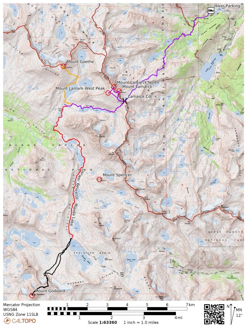
Specs: 40.6 mi | +/- 16,200 ft | 3.25 days, 3 nights
Difficulty: Mostly class 1 and 2, with a few class 3 problems climbing Mount Goddard and Mount Lamarck West [learn more]
Location: Inyo National Forest and Kings Canyon National Park, California | Home of Eastern Mono/Monache and Northern Paiute peoples | View on Map
Route:
First, the class 1-2 on-trail and cross-country routes!
- Trailhead to Lamarck Col: Park at the pack station a bit down the road from the trailhead. On the trail, follow signs for Lamarck Lakes. Just before reaching Upper Lamarck Lake, take the spur trail (clearly marked with a new sign) toward Lamarck Col.
- Lamarck Col to Darwin Bench: Follow the cairns and use trail(s) toward the lakes below, trending slightly west toward the 4th lake (a long, thin one). A social trail winds around the north shores of the various lakes all the way to Darwin Bench.
- Darwin Bench to Wanda Lake: Follow the use trail(s) to the lowest lake, navigating around it on the east side until you reach the outlet creek (stay east of the outlet). A use trail leads down to the Pacific Crest Trail / John Muir Trail; follow this famous route east and then south to Wanda Lake.
Next, the peaks!
- Mount Lamarck: From Lamarck Col, drop down a bit and then contour west through the boulders until you can scramble up to Mount Lamarck. It’s easy to reach the north and west summits of the mountain (north is the tallest) by strolling across the summit plateau. The west peak is the most difficult with a few exposed class-3 moves.
- Mount Goethe: From Darwin Bench, follow the cascading outlet creek from the lakes below Mount Goethe. You’ll need to be on the west side of this creek and it’s easiest to cross down low rather than up near the lakes. Contour around the north side of the lake and then hike up the talus and grassy slopes to a flat-ish plateau north of the head of the lower lake. An obvious rib of talus is the most solid route to the summit; returning on the looser sand (climber’s left relative to the talus rib) makes for an enjoyable descent.
- Mount Spencer: From the south end of Sapphire Lake, descend down one of several grassy chutes to the lake shore and cross via some easy rock-hopping. Make your way up into the basin between Spencer and Huxley, trending northwest to more grassy slopes that lead up to a saddle on the east ridge of Mount Spencer. Follow the class 2 ridge to the summit.
- Mount Goddard [Starr’s Route]: From the PCT/JMT at the foot of Wanda Lake, cross the outlet creek and make for the shallow saddle west of the lake. Contour downhill on the other side to the dark “north ridge” that leads up to the east-west Goddard Divide and Peak 13,040, the one immediately east of Mount Goddard. The easiest way up is the class 2 talus to climber’s right of the ridge; you can also climb directly up the face for some class 3 fun. I mixed the two, abandoning the talus after a few hundred feet and climbing the relatively easy class 2-3 rock to a diagonal, class 2 ledge that reaches the Goddard Divide. From the divide, contour across the talus, staying high to avoid steep ribs below Peak 13040, to the summit of Mount Goddard. For more details, read the SummitPost page for Starr’s Route.
Permits & Regulations: As with all eastern Sierra trailheads, a permit is required for all overnight trips. You’ll also need to store your food properly; I recommend a bear canister as trees are few and far between on this route. Parking is free, but is a little bit of a walk to the trailhead. Please remember to follow the Leave No Trace outdoor ethics, especially in Darwin Canyon and Darwin Bench where there are not established and maintained trails.
Resources: I recommend the Sequoia and Kings Canyon National Geographic map for trips in this area. The Lamarck Lakes Trail USFS is a fantastic resource as well.
Mount Lamarck and Darwin Bench
2 July, 2021 | 9.7 mi | +5000 / -3000 ft | View on Map
I slept at the trailhead last night with mixed results. I was perfectly comfy cowboy camping next to the car until about 3 AM when I woke up and realized that dew was gathering on my sleeping bag. I curled up in the back seat for the rest of the night and got a bit more sleep, but it wasn’t great. Pre-hike sleep is a problem I have yet to solve. Booking a campground can be just as difficult as securing a backcountry permit, and my little car is not big enough to sleep in comfortably. But I digress; this is a hiking and climbing trip report, not a review of camping options.
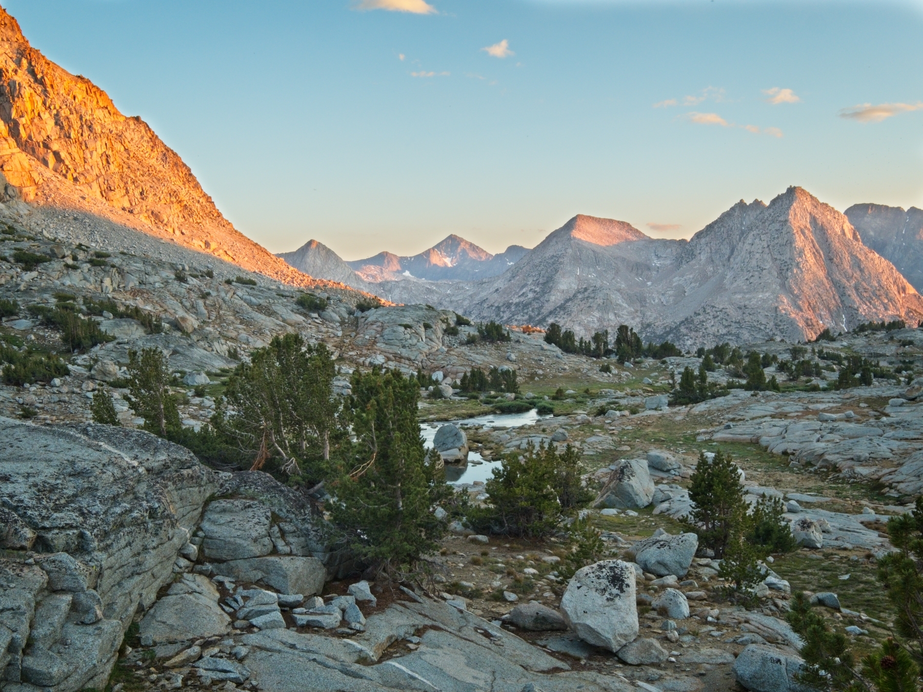
I set out from the hiker parking area near North Lake at about 6 AM. The sun has just barely crested the mountains and bathes the road and nearby meadows in warm light. I stroll through the North Lake Campground a few minutes later and am soon hiking up gently inclined switchbacks in the cool shade of a dense pine forest. Wildflowers abound, a nice contrast from the desert terrain I’ve been hiking through lately. I see irises, lilies, paintbrush, penstemon, and columbines, all within a few minutes on the trail!


It doesn’t take long to reach the Lamarck Lakes. I pause at each lake for a few minutes to admire the crystal-clear water and the surrounding mountains and then move on. The trail to Lamarck Col is well-marked with a new sign just below Upper Lamarck Lake. I hop across the outlet creek and walk through a short section of pine trees and granite slabs to reach a long, steep set of switchbacks.


As I climb up the sunny ridge, I’m treated to an expansive view of Grass Lake and North Lake; I can even see cars glittering in the parking lot! The trail soon reaches a saddle and leaves those views behind. I trudge up some sandy switchbacks, cross a few meadows, slowing down as I gain altitude and stop more frequently to catch my breath.


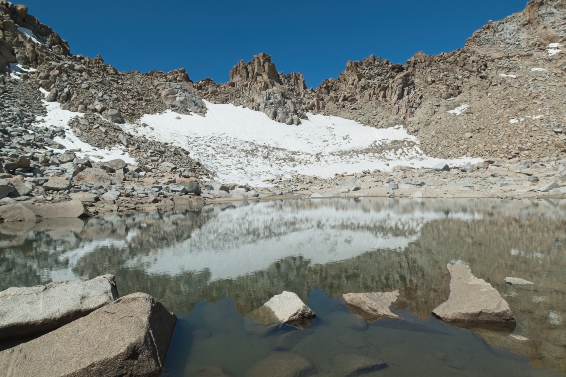
I see several other hikers on my way up to Lamarck Col. One couple is scrambling up the east ridge of Mount Lamarck; another couple hops between boulders on their way to the col; a solo hiker just behind me struggles through the high-altitude sand. A small snowfield covers most of the slope beneath the pass, but is easy enough to hike around and I soon reach the Sierra Crest.
A sign marking the boundary between Inyo National Forest and Kings Canyon National Park protrudes from a pile of rocks on the ridge; I peer past it at Mount Darwin and Mount Mendel, with Darwin Canyon below. I’ll be heading down there later this afternoon, but first I’m going to climb the three summits of Mount Lamarck!


I stash my backpack beneath some big boulders, mark the location on my GPS (the entire mountainside is large boulders…), and begin scrambling up to Mount Lamarck. It’s a pretty straightforward climb, and I’m soon striding across the wide summit plateau toward the peak labeled “Mount Lamarck” on the map. The two climbers I saw ascending the east ridge on the way up are there, so I chat with them for a few minutes while I eat some lunch and admire the views. After eating, I head over to Mount Lamarck North, the highest point on this mountain (by about 50 feet), snap a few photos, and then climb up to the west peak. This final summit proves to be the most exciting, with a few exposed class 3 moves to reach the very top.


After tagging the three peaks, I traverse back across the mountain to where I left my backpack. Even with the GPS location marked, it takes me 10 or 15 minutes to find the bag amidst all the boulders. Thankfully, it’s untouched by marmots! I find the descent into Darwin Canyon very tedious. Although I enjoy plunge-stepping and foot-surfing through the sand, I’m not feeling very good this afternoon and the route finding irritates me. Even the beautiful, teal alpine lakes do little to improve my mood as I rock-hop and scramble around their northern banks.


I’m exhausted by the time I arrive at Darwin Bench. I’m not entirely sure why since I haven’t really hiked very far (9 miles?), but I suspect my poor sleep schedule has something to do with it. Upon examining the map, I discover that I also climbed nearly five thousand feet this morning, which isn’t easy either. That statistic is a bit of a surprise to me; I’ll admit that I didn’t plan this route as carefully as I perhaps should have. I checked for feasibility, but not necessarily for comfort.
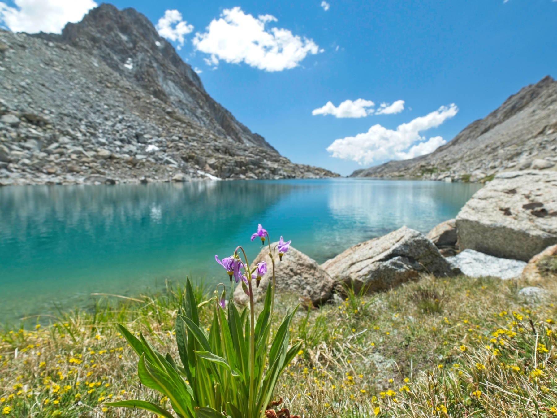
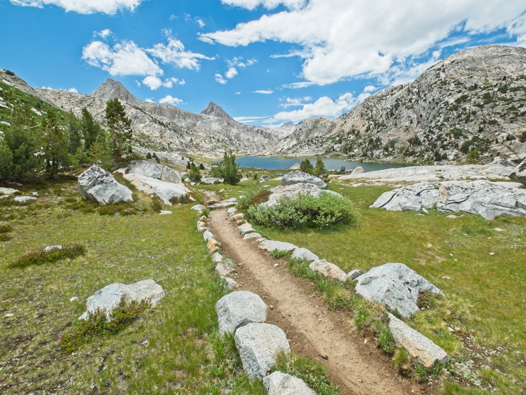
Thankfully, Darwin Bench is so incredibly beautiful that I can’t help but cheer up. Descending from Darwin Canyon, I stroll through spongy meadows, past cascading creeks, and through wildflowers: lupine, shooting stars, asters, mountain heather… absolutely gorgeous!


I have nowhere else to be today, so I take my time picking out a campsite. There are many options and I eventually settle on one near a string of small lakes in the upper part of Darwin Bench. While exploring, I startle a sleeping doe; she lifts her head to look at me, but doesn’t get up from her shady bed as I back away. It’s surprisingly warm this evening, especially since I’m at about 11,3000 feet above sea level. Like the deer, I relax in the shade until the sun sinks below the western mountains and then retire to the tent. A light drizzle falls for a little while, but the sun comes back out later in the evening and paints the peaks pink and orange. I stay up as long as I can bear but fall asleep by 8 PM.
Mount Goethe and Mount Spencer
3 July, 2021 | 11.9 mi | +5000 / -4800 ft | View on Map
As if to make up for my lousy night at the trailhead, I slept really well last night. I get up at about 6, nearly 10 hours after falling asleep, and enjoy a hot breakfast. My first goal today is to climb nearby Mount Goethe. Afterward, I’ll hike over to Wanda Lake and set up camp there, climbing Mount Spencer along the way if I have time.
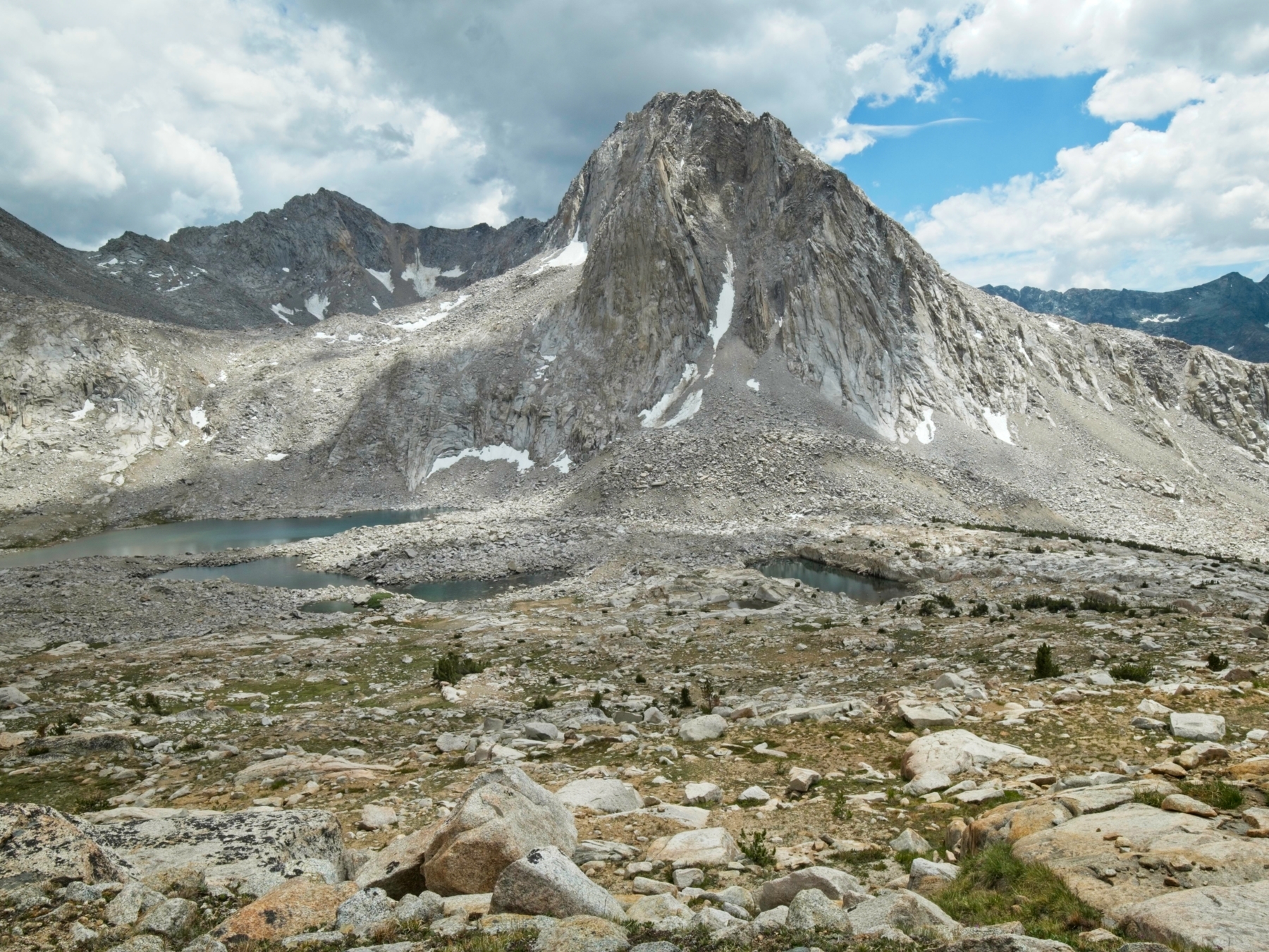
Once I’ve finished eating, I pack a few things into my backpack and follow a creek up to Lake 11,540 which lies directly below Mount Goethe. It’s an easy hike, particularly without heavy camping gear, and I enjoy strolling around the shore to the southern flank of the mountain (although the millions of gnats are a tad annoying). Compared to the noisy, creek-filled Darwin Bench, these lakes are completely silent! From the water’s edge, I walk up a grassy slope to a small, sandy plateau and then traverse across it for a little while. I’m aiming for a prominent rib of talus that leads to the summit and provides a solid alternative to the otherwise loose slope.


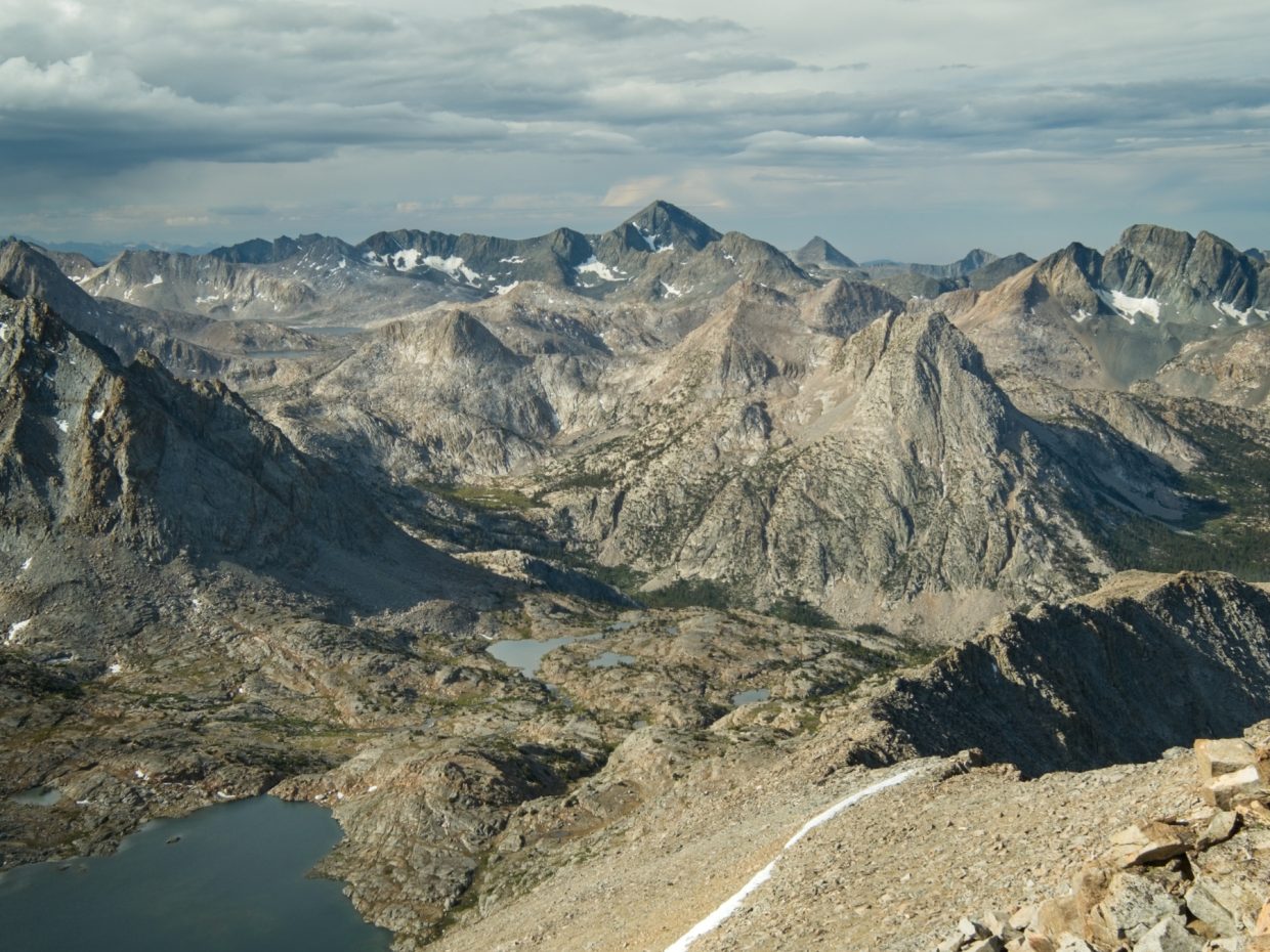
It’s not a particularly difficult climb, but the nearly 2000-foot ascent takes me the better part of an hour. The views from the top are entirely worth the effort however! To the north, Mount Humphreys towers over dozens of lakes. Looking south, I enjoy a sweeping view of the Goddard Divide, overshadowed this morning by dark rain clouds. The pyramidal summit of Mount Goddard holds my gaze; I’m a little nervous about climbing that one!


After taking in the views and signing the summit register, I descend through the loose sand to the lake below and then wander back to camp. I’m struck again by how beautiful this place is; I’m glad I’ll be coming back tomorrow night.


I pack up camp, shoulder my backpack, and follow a faint use trail down to the John Muir Trail / Pacific Crest Trail. Stepping onto this high-traffic path feels a bit like merging onto a highway: there are few obstacles and it’s easy to move quickly. I follow the JMT/PCT to Evolution Lake and enjoy a nice, level stroll around the lake. I remember having perpetually wet feet the first time I hiked here in 2017. I had camped at Evolution Lake and it rained all night long, filling the trail with frequent, unavoidable puddles. Hopefully I won’t suffer that same fate this trip. So far the blue skies promise an afternoon of sunshine, though the clouds have a habit of coalescing into thunderstorms up here…
Beyond Evolution Lake, I stroll toward Sapphire Lake. Mount Spencer rises above the lake to the east and I think I’ll go for the climb! The clouds are gathering a bit thicker, but I bet they’ll hold off for a few hours, giving me plenty of time to climb up and back down. I stash my backpack just off the trail in some trees and then head off cross-country. I follow a grassy chute down to the shore of the lake and then begin a long stretch of talus-hopping. Thankfully, the rocks are incredibly stable and I’m soon striding up grassy slopes toward a saddle east of the Mount Spencer Summit. I continue to keep an eye on the clouds, ready to turn around at the first hint of a storm.


When I reach the saddle, the clouds are still separated by small patches of blue sky, so I decide to push for the summit. The route to the top consists mostly of class 2 terrain and would be a very fun place to sit and look around if I weren’t worried about getting caught in a storm. At the summit, I take a few photos and sign the summit register, which resides in a nifty silver box. Then it’s back across the ridge to the saddle as quickly as I can.


I relax a little once I’ve descending below the ridgeline. A thunderstorm now would be annoying and wet, but not very dangerous. I enjoy the stroll through the basin between Mount Spencer and Mount Huxley, taking more photos on the way down than I did during the ascent. I love this kind of cross-country hiking over mostly-flat terrain full of meadows and granite slabs!
By the time I reach the talus surrounding Sapphire Lake, the patches of blue sky have disappeared and a light drizzle begins to fall. The rain intensifies while I hop across the inlet creek to the other side, and I stop to pull on my rain jacket. A few minutes later, hail the size of peas begin pelting down. I wait out the storm huddled beside my backpack for a few minutes and then continue hiking up the JMT/PCT once the deluge has subsided a bit. My legs and feet are wet and it’s decidedly chilly, so I figure a brisk walk is the best thing to warm me up. I also want to get to my campsite and set up the tent before any more afternoon storms blow through. Lightning strikes near Evolution Lake as I walk south; I’m sure glad I got down from Mount Spencer before the storm arrived!


It doesn’t take me too long to reach Wanda Lake and I waste no time setting up my tent on a small hill overlooking the lake and the trail. I’ve dried out a bit from the walk, but I set up a little clothesline between my tent and a large rock and hang out a few wet items. The sun peeks out from the clouds for a few minutes, and a stiff breeze helps to dry everything out. Another line of ominous clouds approach from the south, but only drop a drizzle, so I stand out on a rock near my tent and greet hikers as they hurry north away from the storm.


An hour or so later, the dark clouds dissipate and one final sheet of drizzle drifts through. The sunlight breaks through the clouds and creates an incredible double rainbow! The drizzle soon drifts away, and the rainbow fades, but I’m glad to have witnessed such a beautiful spectacle, a fitting reward for sitting out an afternoon thunderstorm.


Mount Goddard
4 July, 2021 | 11.5 mi | +4400 / -4300 ft | View on Map
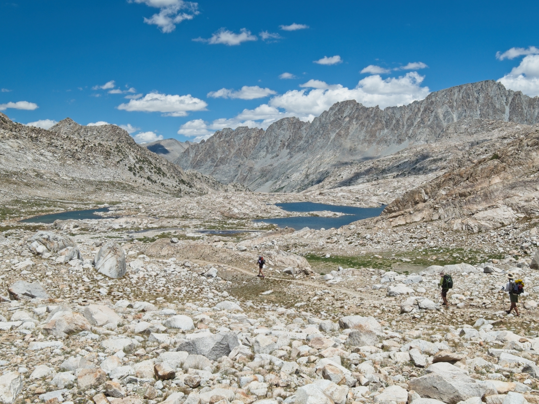
I could not fall asleep last night! I tossed and turned until midnight and only slept for a few hours before my alarm went off at 4:45. I’m determined to get an early start since rain clouds overshadowed Mount Goddard yesterday morning as early as 9 AM and thunderstorms rolled through at 3 PM. Thankfully, the sky is completely free of clouds this morning and I’m hopeful that I’ll be able to complete the climb. I leave camp at 5:30 and begin the cross-country trek to the base of the climb. Like much of the High Sierra, the route consists mostly of talus hopping, so it takes me about an hour to cover the 1.9 miles to the foot of the ridge.
There are a few options to begin the climb. One is a class 3 scramble up the face of the ridge for 30 or 40 feet. It doesn’t look too bad, so I give it a try but get stuck halfway up and end up downclimbing. With proper climbing shoes and a partner, I might be more bold, but I’m not going to risk falling this morning. I follow a much easier, class 2 talus climb to the right of the ridge for a little while and then move up onto the ridge and enjoy mixed class 2 and class 3 climbing. Well, “enjoy” is perhaps too strong a word… some of the rock is fun to scramble up, other bits are terribly loose and tedious.
Near the top of the ridge, I follow the obvious ramp to a notch in the ridge (this is Starr’s Route). The view down the other side nearly breaks me. I curse under my breath as I stare across the mountain toward the summit. It looks so far away, and it’s entirely talus, a real slog! But I didn’t climb all this way to turn back because the terrain is tedious, so I sigh and begin contouring across the mountainside. At first, I struggle through some pretty loose stuff but it stabilizes in a few hundred yards and I actually enjoy the final half mile.


Joseph LeConte wrote in the Sierra Club Bulletin that the view from the summit of Mount Goddard is “unquestionably the most extensive to be found in the Sierra” [Roper, S., Sierra High Route, pp. 129]. I haven’t climbed all that many other peaks in the Sierra, so I can’t really verify his claim but the view is definitely excellent! I spend a good half hour looking out in every direction and make sure to sign the summit register. There aren’t that many names in it, and I find a few friends in there that summited a couple of years ago!


On the way down, I scramble up peak 13,040 since it’s right beside the route. Descending the ridge proves to be a little easier than the ascent, but it still takes me several hours to reach the basin below Mount Goddard. I enjoy hopping through the stable talus on the way back to Wanda Lake, stopping along the way to eat some lunch beside a tarn. By the time I reach my campsite, it’s 11:30 and I’m ready for a nap.


 growing in the rocks on the north ridge")


I rest for a few minutes, but it’s too hot to nap in the tent so I pack up and begin a leisurely walk back toward Evolution Lake on the JMT. I pass lots of hikers on their way to Muir Pass and a few heading the same direction as I am. I rest for a little while at Evolution Lake, which is empty and quiet this early in the afternoon. I’m sure it will fill up with campers tonight; many people (myself included, on past trips!) make a point of camping here.
I leave the trail a short distance below Evolution Lake and begin the final climb of the day back up to Darwin Bench. Much like Friday, I’m tired and a little cranky as I trudge up the steep trail in the hot afternoon sun. But the gorgeous lakes and meadows in Darwin Bench once again cheer me up! I make a point of choosing a shady campsite, perfect for afternoon napping, and spend the rest of the evening relaxing.


Return to Lamarck Lakes Trailhead
5 July, 2021 | 7.5 mi | +1800 / -4100 ft | View on Map
I get an early start this morning. Contouring around the lakes in Darwin Canyon only takes me 45 minutes, and I finish the climb to Lamarck Col in another hour though it’s a real slog and I stop frequently to catch my breath. Even after three consecutive days of climbing 13000-foot peaks and sleeping above 11,000 feet, climbing up to the 12,880-foot pass still destroys me! I fly through the descent to Lamarck Lakes, passing a few backpackers and then a bunch of day hikers below the lakes. It’s another warm day and I’m glad to be descending rather than climbing up the steep trail.


I reach my car well before noon and head off to grab a sandwich from Schat’s Bakkery in Bishop for lunch. It’s one of the most popular places in town, and for good reason. I eat outside with a bunch of PCT thru-hikers who are at least as stinky as I am and then begin the long drive home. I can’t wait to come back and climb more of these mountains!