I’ve been meaning to meet up and do some climbing with my friend John since I moved to California a few years ago. We finally made it happen this weekend with a day trip up the East Arête of Mount Humphreys! This is only the third technical alpine climb I’ve completed, so I was happy to have an experienced climbing partner. We got lucky and enjoyed a beautiful sunny day while completing this classic climb.
Trip Planning
Specs: 7.5 mi | +/- 5100 ft
Difficulty: The difficulty of the route varies between guidebooks and online sources, but people generally agree that the most difficult climbing is between 5.4 and 5.5 with two rappels to skip 5.6 and 5.8 downclimbs. The ridge traverse also includes plenty of exposed class 3 and class 4. I’ll note that most of the climbing relies on vertical cracks and pinches, so calibrate the difficulty accordingly. [Difficulty Ratings]
Location: Inyo National Forest, California | Home of Eastern Mono/Monache and Northern Paiute peoples | View on Map
Route
- Approach: Begin at the end of the Buttermilks Road (37.27619, -118.63054). This road is incredibly rough and requires a large, high clearance vehicle to navigate. Follow the trail and then break left, heading cross-country to the west. Stay left of the cliff bands and head up one of the sandy, loose gullies, sometimes on use trails. Before reaching the lake at 10,990 (a few camping spots here) head northwest to the saddle between peak 13151 and peak 12241.
- Climb: Follow the ridge toward peak 13151, staying on the ridge as it tries to force you off left (south). Climb fun 3rd and 4th class and walk the cool knife-edge ridge. As you approach peak 13151 you are forced off the ridge to the south and must make a few 5th class moves, meandering back and forth to reach the summit of 13151. From here, descend the ridge and encounter a short, steep notch – a 5.7/5.8 downclimb or rappel. Continue down the ridge, up the next sub-peak, and then complete a 5.6 downclimb or rappel to reach the main notch. Gain the ridge again as soon as possible via a 4th class trough. Continue on the 3rd/4th class ridge to a headwall. Go around the corner (it is very exposed) to the left and climb up 5.2 cracks. Third class terrain leads to easier ground and eventually a flat plateau. Turn right (north) toward the summit, staying low and to the left of the ridge to reach a notch, “Married Men’s Point.” Pick out the easiest line and climb about 100 ft of 5.4 – 5.5 rock, followed by 3rd class terrain to the summit.
- Descent: Downclimb the route to the main notch, rappeling where desired. From the notch, take the scree gullies (very loose, be careful!) to the south to the talus field below. Head east over the talus to grassy slopes and trek cross-country back to the starting point.
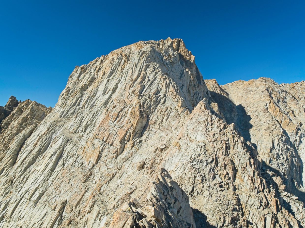
 route up the East Arête; I've marked what I think is the \"official\" route in dashed orange near the end of the visible route")
 route up the cliff face just below the summit; existing rappel stations are marked")

Gear: We carried a single 60m rope and a light trad rack, including a full set of nuts and cams between 0.5 and 2.0, plus assorted slings, carabiners, etc. John felt comfortable soloing most of the 5th class terrain and only placed a few pieces. The rappel stations all had reasonably fresh slings so we didn’t replace any but you should be prepared to leave a sling or two.
Permits & Regulations: No permits are required to day hike in this area. Overnight trips in Inyo National Forest do require permits; look for the Upper Buttermilk Trailhead on Recreation.gov. Most of this hike is above 10,000 feet, so campfires are prohibited. All of the usual regulations about food storage, group size, and wilderness travel apply; see the trailhead website for details.
Resources: Check the Upper Buttermilk Trailhead page for up-to-date information about the area. The Bishop Climbing Report often has notes about the continuously variable condition of Buttermilk Road. For route information, check out MountainProject and SummitPost. The SuperTopo website also includes some useful route data, including a climbing topo.
Bluebird Climbing
01 Oct 2022| 7.5 mi | +/- 5100 ft | View on Map
John and I drove most of the way up the Buttermilk Road last night and camped in an aspen grove. Although navigating up the rugged road in the dark was a bit… exhilarating, I’m glad we got a night of acclimation at about 8700 feet before attempting to climb Mount Humphreys (13986 ft). John did a great job with the driving; I’m not sure I’d want to drive up here even if I had a big enough car.
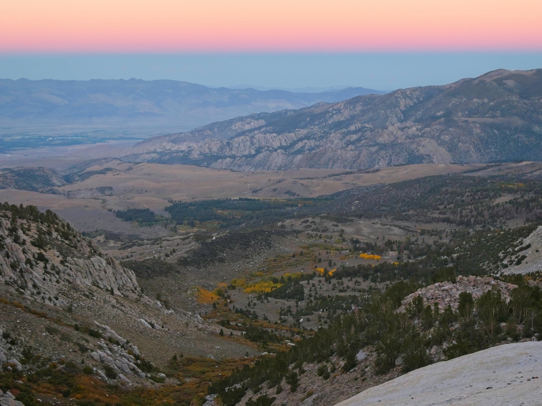
After eating breakfast, John drives us the rest of the way up the road to a small valley. We begin hiking at 7:30 on a single-track trail that leads toward the Heaven Bouldering area but abandon the trail pretty quickly, heading cross-country through dense sage brush. There’s no clear use trail to follow so we choose our own path, generally following the drainage below peak 12241. A grove of bright yellow aspens in the valley below catches my eye – peak color has arrived!


We continue uphill to the left of the drainage, weaving between a few small cliff bands, until we reach a flatter area. Mount Humphreys’ east ridge is now visible, so we make a beeline for the low saddle. Contouring (or “side-hilling,” as some call it) across the sandy soil is a bit tedious but thankfully the slope isn’t too steep. Along the way John points out a few mountain bluebirds flitting between stands of trees; their vibrant blue feathers stand out against the dark green foliage and light colored rocks. We couldn’t have asked for better weather today! This is what skiers call a “bluebird” day – not a cloud in sight. The temperature is also comfortably cool and the wind is light and breezy.


When John and I reach the saddle at 9:10 we take a quick break to apply sunscreen and eat some snacks. The next challenge is to reach the ridgetop. I had imagined that the saddle would sit on the ridge itself, but it doesn’t; we first have to scramble up some tediously sandy slopes. The rocks above the sandy slopes are quite steep so we contour below the ridge for a little while. From the look of the terrain ahead, we could continue along on slabs, benches, and sand for a long ways, but the ridgetop route is supposed to be great climbing so we’re continually looking for a way up. We find a spot to scramble up soon enough; the climbing is definitely fifth class up a series of cracks. It’s a little tricky in my trail runners, but it is a lot of fun!
Once on top of the ridge, we stick to the crest. Several sections with a lot of exposure slow us down a bit, not because the climbing is particularly difficult but because we’re thinking about each hand and foot placement. John jokingly calls the exposed scrambling “danger walking,” which is a fantastic name for it. Just a short distance up the ridge we reach the famous knife-edge section. The rock forms a nearly perfect peak, like a rooftop, with smooth, steep slabs on both sides. The exposure is breathtaking but the peak of the ridge is a foot or two wide and easy enough to walk across. We both pose for photos on top of the knife-edge before quickly walking to safer ground on the opposite side.


Beyond the knife-edge feature, we continue scrambling upward on terrain that ranges from easy 2nd class to 5th class cracks. I’m having a ton of fun playing around with the crack climbing, but after a few short climbs I try to find easier terrain to save time. We have a lot of ridge left to traverse! John and I navigate several more very exposed sections and then reach a steep notch that I am absolutely not comfortable downclimbing. A set of slings and rappel rings allow us to rappel down the short pitch instead. We then downclimb some fourth and fifth class rock to a saddle just below peak 13151. Finally, some straightforward scrambling leads us to the summit of 13151 at 11:15 where we take another snack break.
Although we’ve come a long way on the ridge, Mount Humphreys still looks far away. An impressive amount of technical-looking rock remains between us and the summit, so we don’t sit for too long. Scrambling down proves to be a bit exposed but not as technical as it appears from above. There is a very short 5.6 section with a zig-zagging crack that John downclimbs and I rappel, but otherwise the terrain is all class 3 – 4.


!")

Once we reach the sandy saddle below peak 13151, the difficulty eases up for a little while. We find the class 4 trough and return to the ridge, weaving through boulders and ledges as we gain altitude. The headwall described in the route description is obvious when we reach it, but the way around it is not. I look around to the left and see a steep ramp with a crack leading up the center but can’t see any easier terrain around the corner. In retrospect, I think the 5.2 section is further around the corner, but you have to commit to some airy class 3 moves to get around a rib of rock.
I don’t feel comfortable free soloing the slab/crack route, so we change into rock shoes and John leads the way up, placing one or two pieces of protection along the way. He spends a few minutes flummoxed by an overhanging roof but finds an easier route around a corner to the left. Once he’s reached an anchor he belays me up the crack. I’m not a very experienced crack climber and find the moves pretty challenging. There’s not much to hold on to besides the crack, so I’m constantly wedging my hands and feet in and just hauling myself up the face. After a bit of struggling, I reach John’s anchor and we coil up the rope.
Thankfully, the next section is much easier (class 1 – 2). We hurry up the remaining ridge and across a sandy plateau to a talus bowl. Across the bowl, a tall, crack-covered wall guards the summit pinnacle. We descend into the bowl and walk over to the foot of the cliff, a spot named “Married Men’s Notch” since married men (allegedly) turned back here, unwilling to risk the climb with a spouse or family at home. Neither John nor I are married and John is confident about the climb, so he free solos the wall and builds an anchor at the top of the 20 – 25m pitch. I follow him up, passing two rappel anchors on the way to John’s anchor. I really enjoy climbing up the crack system but am grateful for the belay.

From the top of this final 5th class pitch, it’s just a short class 3 scramble to the summit! We arrive at about 14:30 and take a break for a few minutes. I’m feeling pretty tired and apathetic, probably because I haven’t been eating or drinking enough, so I scarf down some salty snacks and drink a bunch of water. We sign the summit register and snap photos of the spectacular landscape below. I’ve hiked across Humphrey’s Basin a few times so I really enjoy looking down on it from nearly 14,000 feet.


After enjoying the summit for a little while, John and I begin the descent. We scramble down to the highest rappel anchor and, after inspecting the half-dozen slings, rappel back down to the foot of the cliff. The 60m rope earns its weight here, allowing us to rappel the entire wall in one go rather than two shorter rappels. We hurry back across the talus basin, across the plateau, and then scramble down to the rappel anchor above the headwall. Rather than follow the crack route, we rappel directly down the wall.
From the foot of the headwall we continue down the ridge, following our ascent path as closely as we can remember. There are a few tricky class 4 – 5 spots that I downclimb slowly, but we make pretty good time overall and reach a sandy saddle that marks the end of the technical climbing at about 17:00. I’m relieved to change out of my rock shoes and back into comfortable trail runners! It’s also nice to get the rope off of my shoulders and into a backpack.
For the next hour or so, John and I foot-ski down two thousand vertical feet of horribly loose sand and scree. Although it’s faster than scrambling across exposed rock, I don’t really enjoy this descent and am happy to reach stable talus. We stay to the left of the talus field when we can and begin angling across the mountainside toward the car when we reach flatter, grassy slopes.


The sky glows orange and pink and alpenglow illuminates the White Mountains as we work our way down the mountain. Darkness falls at around 18:30 while we hurry down the ridge to the sagebrush-choked meadow. I click on my headlamp and struggle through the brush, following John who is navigating via cellphone flashlight. We reach the car at about 19:30, a nice even 12 hours from the time we began the hike. Dinner is calling, so we waste no time piling into John’s truck and driving back to Bishop.
Michael Bartling 26 January 2026
Congratulations, a neat adventure! I enjoyed the pics. “Almost”-perhaps you were at 14000 feet. The Sierra is uplifting all the time through what is known in geology as “Creep.” Do you plan on making a Mr. Williamson climb? That would be most interesting. Thanks for sharing.
Andrew 27 January 2026 — Post Author
Thanks Michael! I actually hiked Williamson in 2021; here’s the trip report.