Black Mountain and Diamond Peak, both listed on the Sierra Peaks Section list, are located at the top of the drainage containing the Baxter Pass Trail. After a rather unpleasant experience on that trail in July, 2018, I wasn’t excited to return, but I figured I’d hike it early in the season when there was still some snow and the weather was cooler. Besides some tedious bushwhacking, it turned out to be a nice enough hike and the views from both peaks were incredible!
Note: Baxter Pass, Black Mountain, and Diamond Peak are all located in the California Bighorn Sheep Zoological Area. Between 1981 and 2010 this area was closed for much of the year to protect the endangered sheep. However, the Forest Service lifted the seasonal restrictions after study showed the sheep population rebounding and its resilience to people passing through these areas.
USFS, “Forest Service Proposes to Change Designation of Bighorn Sheep Zoological Areas”, 2010
Trip Planning
Specs: 17.8 mi | +/- 8700 ft | 3 days, 2 nights
Difficulty: Class 2 [ratings]
Location: Inyo National Forest, CA | Home of Eastern Mono/Monache, Western Shoshone, and Northern Paiute peoples|View on Map
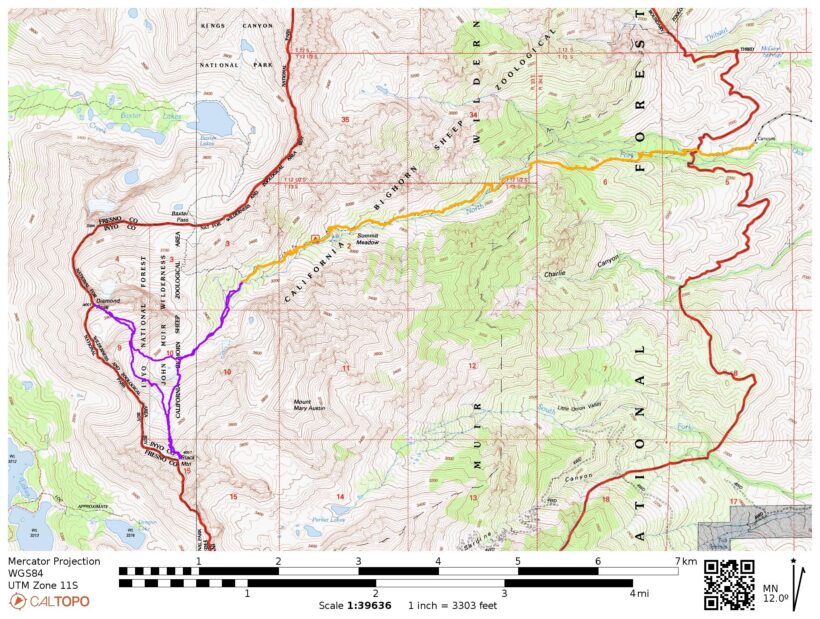
Route: The road to Baxter Pass is mostly dirt, but well-graded and easily passable without clearance or 4WD. Hike up the Baxter Pass trail to the high meadows at about 10,800 feet, where the trail turns north toward the pass. Leave the trail and hike southwest up the canyon to the cirque between Black Mountain and Diamond Peak. There are several chutes that lead to each peak, all class 2.
Permits & Regulations: You need a wilderness permit for overnight trips in this area; see the Inyo National Forest Wilderness Permit page on Recreation.gov. You must store your food in a bear-proof containers or use the counter-balance technique. Otherwise, the usual wilderness regulations (Inyo | Seqouia) apply, including no campfires above 10,400 ft!
Resources: For trailhead information, visit the forest service page for Baxter Pass. Secor’s The High Sierra: Peaks, Passes, Trails book provides a wealth of info about the peaks and cross-country routes.
Fleeing the Afternoon Heat
13 June 2025 | 5.3 mi | +4700 ft | View on Map
I leave Los Angeles at 9:00 and arrive at the trailhead around 13:15, just in time for the hottest part of the day. The car thermometer reads 90 deg F, but there is a stiff breeze, so at least I’ll have some hope of cooling down. I hit the trail at 13:40 and begin up the sandy path. It’s much greener than the last time I was here, which I attribute to the early date and the reasonable amount of snowfall we got this year. Beautiful white, bell-shaped flowers and the usual collection of chaparral brush line the trail, and there are very few trees. I cross the creek twice within the first mile – I manage the first via a trekking-pole-assisted standing long jump, but end up getting my feet wet in the much wider second crossing.


At mile 2.6 (8300 ft elevation), I reach the third and final creek crossing in a canyon that focuses the power of the creek into a narrow stream. I don’t see any section that I want to wade through, but there are a fair number of downed trees lying across the water. I find one that’s wide enough to scoot across and manage to make it over the roaring creek without getting my feet wet a second time.
From here, the trail climbs up the northern side of the canyon, passing through 20 – 30 feet of stinging nettle in the lush greenery near the water. Farther above the water, the trail weaves through chaparral, thickets of willows, and dozens of rock piles left by flood waters, avalanches, and rock slides. The trail practically disappears in several places, completely obscured by dense plants, or vanished into thin air where the creek has carved out a new path. There are cairns to mark the way, so I don’t lose the trail for long, but the extra mental effort is noticeable. (The trail could really use a few days of work with shears; trimming the plants would resolve 90% of the issues!)


Every year I notice that the first backpacking trip of the season feels unusually difficult, and this year is no different. I’m really tired, and the altitude is starting to kick my butt. It’s also still incredibly warm and I’m dripping sweat despite the nice breeze. But at least the scenery is getting nicer! As I gain elevation, the flora transitions from sage brush, manzanita, and mountain mahogany to whitebark pines and Sierra juniper, markers of the subalpine zone.
I find a nice little campsite just off the trail at about 10,700 ft. It’s very close to the creek, there are plenty of trees around, and nearby cliffs provide shelter from the wind. It’s now 6 PM, so the timing has worked out perfectly: I got to sleep in at home and still made it to camp before dark! I am exhausted though and very glad to be done walking for the day. I set up my tent, eat dinner, and then relax for the rest of the evening.
Black-Diamond Traverse
14 June 2025 | 7.2 mi | +/- 4000 ft | View on Map
Despite my exhaustion, I didn’t sleep well at all during the night. I tossed and turned the whole time, finally getting up at 4:30 when my alarm goes off. My plan for the day is to climb Black Mountain and Diamond Peak, linking them together with a contouring line at 11,800 feet that Secor calls the “Black Diamond Traverse.” The most recent satellite images show a lot of snow up higher so I’ve brought mountaineering boots, crampons, and an ice axe to protect against slips and falls. I’m starting at 4:30 so that I can do the uphill section while the snow is firm while simultaneously avoiding cross-country route finding in the dark. In retrospect, there was a full moon and I could have navigated just fine in the “dark,” but I didn’t think of that until too late.


So I get up at 4:30, eat some breakfast, gather my gear, and start walking at 5:30. I leave the trail almost immediately, hiking across a beautiful meadow and then starting up low-angle, sun-cupped snow fields. I’m in trail runners for now, and they work fine on the frozen snow; the sun cups are perfect steps and it’s not steep enough to worry about falling. The sun rises very soon after I reach the snow, casting golden light across the otherwise blue landscape.
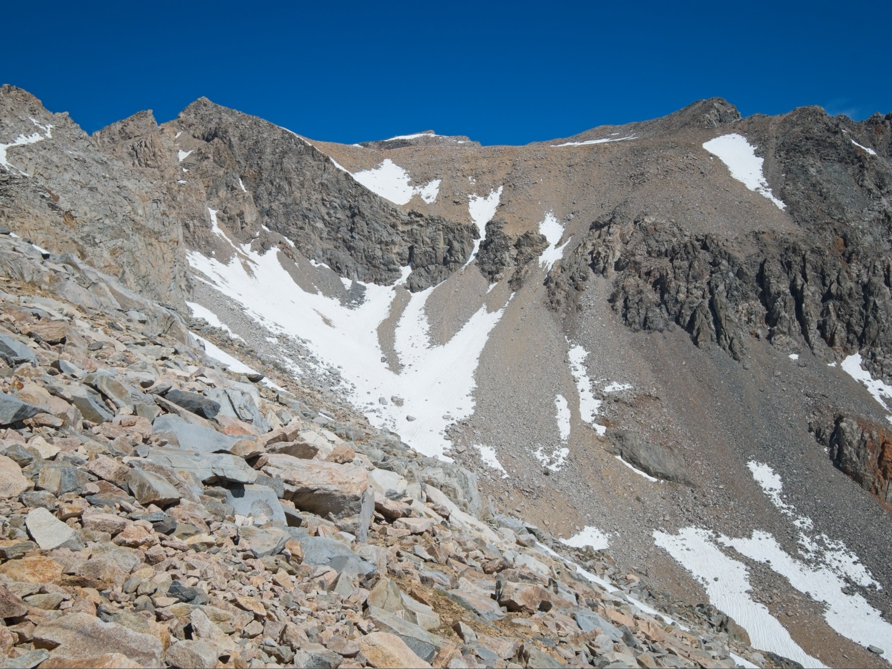
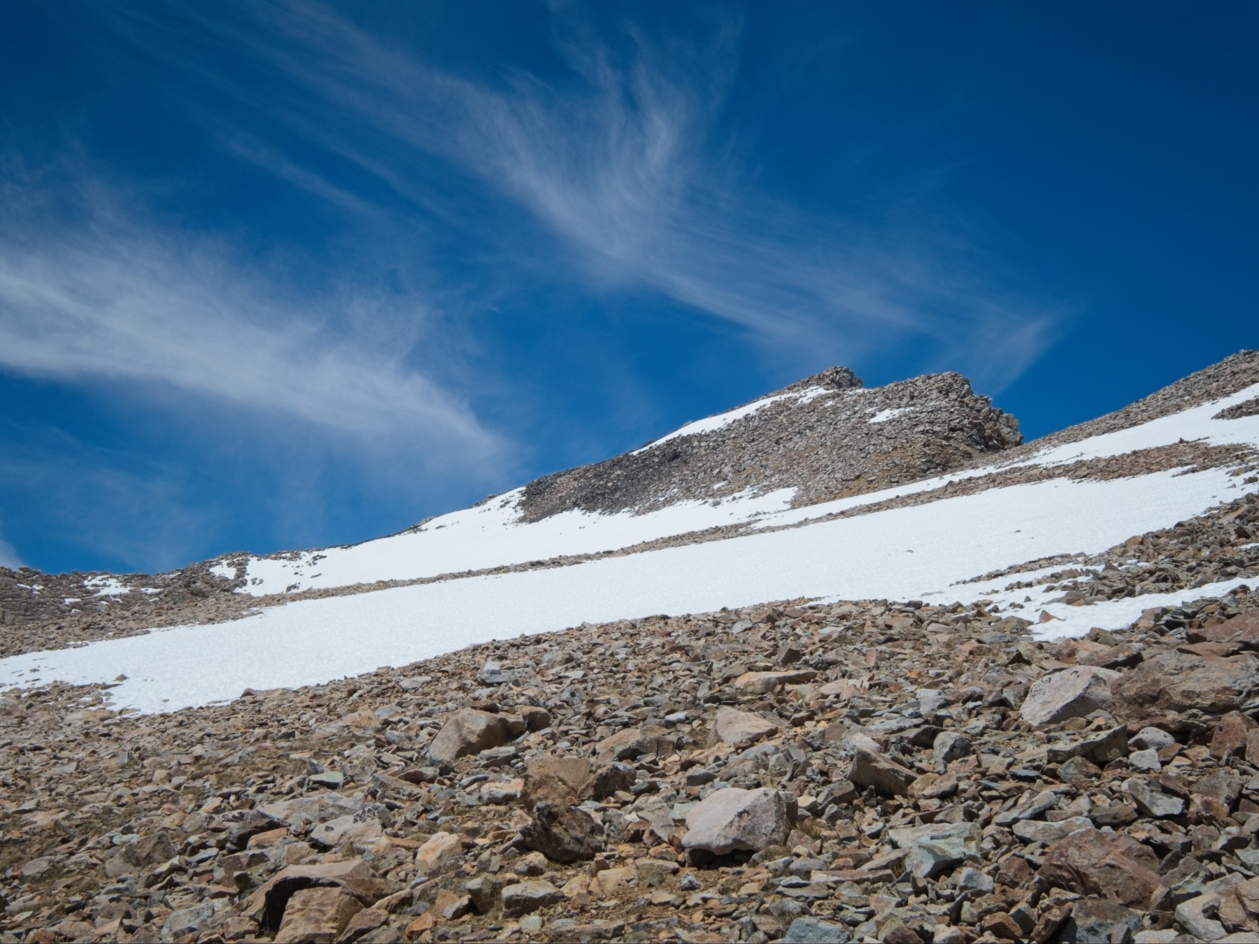
About a mile up the canyon I reach the deep cirque between Black Mountain on the left and Diamond Peak on the right. The north-facing slopes that lead up to Black Mountain are almost entirely snow-covered and fairly steep – I’m glad I carried the mountaineering boots up here! On the other side of the valley, equally steep scree slopes lead up to Diamond Peak with a few dwindling tongues of snow that might offer solid steps up the majority of the slope. Given the abundance of snow on Black Mountain, I decide to climb it first to take advantage of the firm conditions; I don’t want to be on the snow when it softens up and I start sinking in.


I take a few minutes to put on mountaineering boots, crampons, gaiters, and gloves. Then I start out across the frozen snow, ice axe in hand, feeling very satisfied with the security the crampons provide. I follow an upward-sloping diagonal line to avoid rocks and stay on the snow as long as possible.
After about 30 minutes of zig-zagging up the snow, I reach a small hanging valley that leads to the summit. The snow transitions to soft dirt and rocks here, so I pop off the crampons and trudge up low-angle scree toward another, steeper snowfield that stretches all the way to the summit. It’s a slow slog, both because the loose soil and rocks are tedious to walk through and because the thin air up here at 11,800 feet forces me to pause periodically and catch my breath.


I take my time climbing up the final snowfield. It feels very steep, though I don’t think the angle is more than 35 degrees. The snow is still frozen solid and my crampons bite the ice well enough, but it’s always a little nerve-wracking to trust those few steel spikes with all of my weight. At the top of the snow, just below the summit, the angle increases to the point that I feel most comfortable front-pointing with the crampons; 10 – 20 feet of climbing brings me to the summit ridge and dry rock!
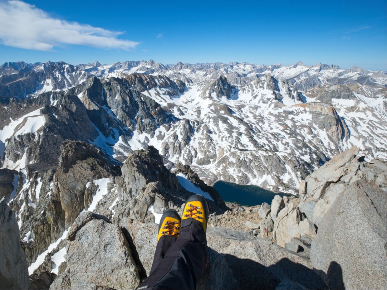
Rather than scrambling up the talus with the crampons on, I pop them off and leave them and my ice axe on a wide rock and scramble to the top without spikes. I arrive at the 13,291-foot summit right at 8:30, three hours from camp, and am awed by the views! Looking south, several 14ers stand out: Williamson, Russell, and Whitney. Dragon Lake lies directly below, and I can just make out a boot track on snow-covered Glen Pass across the valley. I spend a few minutes on top of the peak, admiring the views, and then begin the descent.


On the way down, I avoid the steep snow as much as possible, instead scrambling down the rocky ridge. A few tricky class 4 moves are required, but I make it to the loose soil and rocks without incident and enjoy a relatively easy descent down the hanging valley. I have an excellent view of Diamond Peak the entire time and seriously debate skipping it. The snow only reaches 1/3 – 1/2 of the way up the slope, and the rest looks horribly loose, a very unpleasant slog. But as much as I’d like to skip that climb, I want to come back to this valley even less than I want to do the climb, so I guess I’m doing it today!
Secor’s advice for the Black Diamond Traverse is to stay at about 11,800 feet. The hanging valley below Black Mountain cliffs out at 11,900 feet, so I have to find a way to drop down. The snowfield I’m on ends in a cornice above a small chute that leads down a snowfield that I can traverse across to Diamond Peak, so I carefully walk around the cornice and begin climbing down the chute. (The better beta is to traverse a bit higher, only dropping down to 11,800 once you’re to skier’s left of the cliffs.) As I make my way down I discover it is much looser than it looked from above. Every single rock is slightly loose and I have to take great care to avoid sending them (or me!) crashing down the chute. Partway down I hear rattling from above and press myself against the snow as a shower of small debris comes raining down the chute, bouncing off my helmet and dribbling into my shirt and backpack.
After what feels like half an hour (but is in reality about 10 minutes) I reach the bottom of the chute and eagerly move out of the fall zone, out onto a sun-baked snowfield, once again with crampons and an ice axe. I still need to descend, so I carefully step down the snow. To speed up the descent, I attempt a glissade (sans crampons – glissading with spikes is a good way to break an ankle) but the snow is either too sun-cupped or too icy for glissading to be helpful. After barely arresting a slide on an icy patch, I give up and just boot down the snow.
By the time I reach the scree slopes below Diamond Peak, it’s already 11:00 and my enthusiasm is at an all-time low. But I am already here at 11.8k feet, and the summit is only 1300 feet above, so I might as well give it a go. I follow the snow as far as I can, up to about 12.3k feet, and then scramble up scree, sand, and talus to a much gentler slope at 12.8k feet. Very tired from the climb, I take a break for lunch and stare up at the summit; just a few hundred feet to go!
After a short rest and a final push, I reach the summit of Diamond Peak at 12:30. The views are great, though not quite as dramatic as the view from Black Mountain. Directly below the peak I can see Arrowhead Lake and the long, gentle canyon that leads down to Woods Creek. Somewhere down there is the Pacific Crest / John Muir Trail!


I enjoy the descent from Diamond Peak much more than the descent from Black Mountain, though “enjoy” is perhaps too strong a term; I’m less afraid for my health and well-being. I’m able to plunge step through some of the soft scree, which is decidedly better than slipping and sliding on the more solid rocks. Once I reach the bottom of the cirque, I follow the snow back down the hill. My feet hurt in the mountaineering boots, but the boots provide stability in the soft snow and my trail runners would soak through in a hurry. So I deal with the discomfort, reaching the meadows where I began this climb at about 3:00. A short jaunt down the trail brings me back to camp.


For a few minutes I debate hiking out this afternoon… it’s 3:30, so I could be packed up by 4:30, down to the trailhead by 7:30, which would put me at home sometime around midnight. As tempting as my own bed is, I’m too tired for that kind of sustained effort. A nap sounds nice, and I have a book to read. Besides, it’ll be nice to spend the afternoon up here in the high country, away from the hot, dusty desert.


I spend the rest of the afternoon lazing about camp, napping, and reading Kaveh Akbar’s excellent novel, Martyr! I test out my phone’s satellite texting capabilities and am pleasantly surprised to find that it works really well. Not only can I send and receive text messages without cell service, but it isn’t eating that much battery.
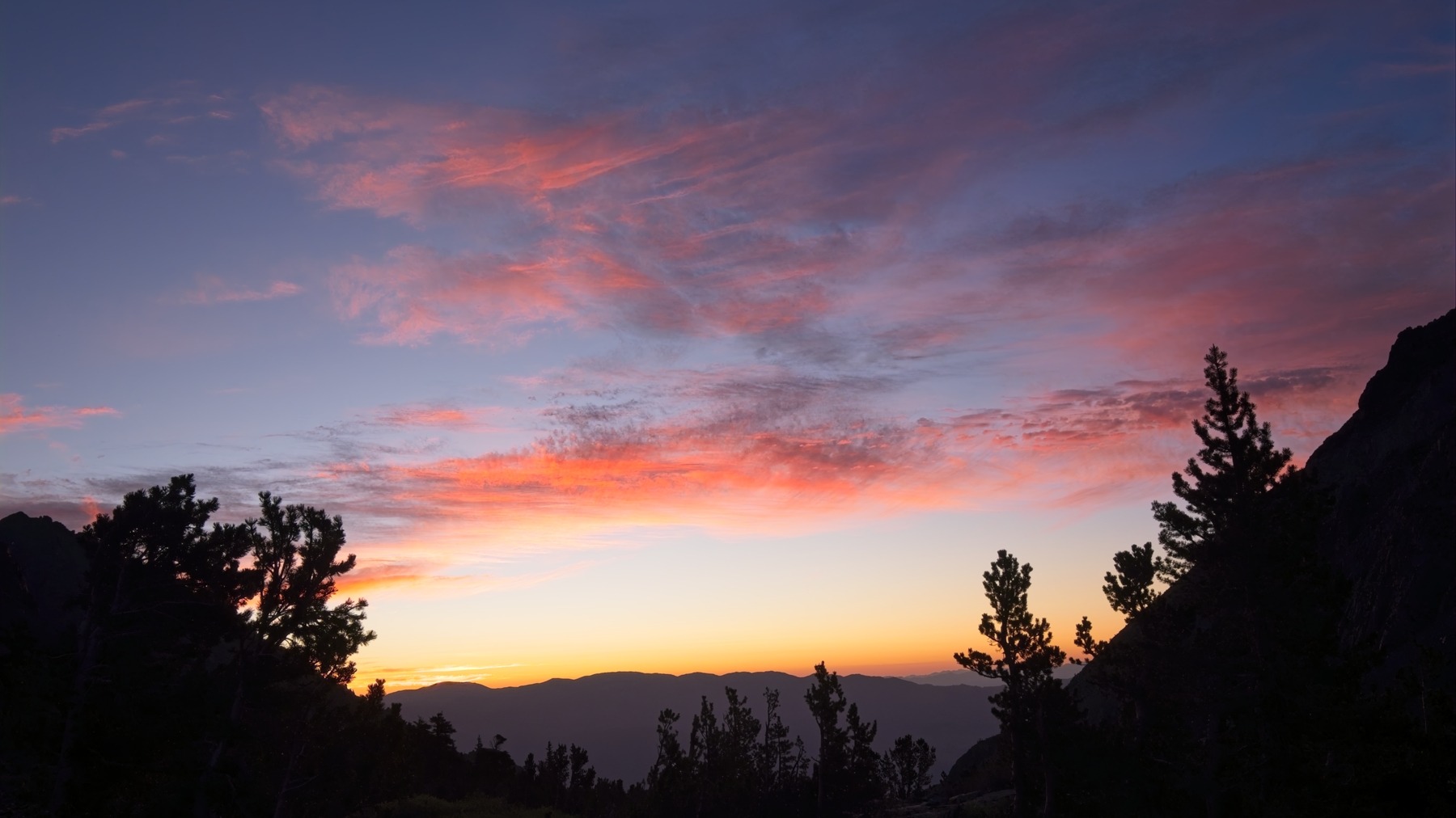
Later in the evening I wander back up to the meadows just below the snow and snap some photos in the warm evening light. It’s been a while since I’ve dedicated time to photography and I thoroughly enjoy it. Once the light fades, I stroll back to camp, eat dinner, and go to bed early.
All Downhill
15 June 2025 | 5.3 mi | -4700 ft | View on Map
I wake up feeling well-rested and mostly recovered from yesterday’s hiking at 5 AM. Eager to hit the road and get a hot breakfast, I pack up camp and hit the trail. The warm light streaming through the trees is beautiful and I enjoy the cool morning air for as long as it lasts… the lower I hike, the warmer it gets.


I have a slightly easier time following the trail on the way out than I did on the way in, but I still lose it a few times. When I reach the creek crossings I’m disappointed to find that the water level is just as high as my hike in; sometimes the water level is much lower in the morning before the sun starts melting all the snow up high. The log I used to cross earlier is now wet and slippery, so I cross via an exhilarating flying leap. When I reach the second crossing, I decide to just get my shoes wet and wade straight through the shallow water. It’s only a mile back to the car, and I have sandals waiting for me.


I reach the car at 9:00 and happily change into clean, cool clothes. It’s been a nice weekend and I’m happy to have checked off two more of the SPS peaks!
Craig 1 July 2025
Great trip report. You definitely could have used more snow for Diamond Peak!
Andrew 10 July 2025 — Post Author
Thanks Craig! Yeah, a little more snow would have been nice…
Diane McKelvey 11 July 2025
Hi Andrew – Another great trip report with stunning photos. The Baxter Pass trail is a grunt, alright. I think there is a sign at the Rae Lakes end of the trail that warns that it is an unmaintained trail and they mean it ! Views from the top of Black and Diamond look splendid – what an amazing part of the Sierras. Thanks for posting this.
Diane in Kamloops