With the 4th of July falling on a Friday this year, I was eager to take advantage of the long weekend and go backpacking in the mountains. My plan was to hike from Bloody Canyon, up over Mono Pass, Parker Pass, Koip Pass, and Gem Pass, and then down Rush Creek. Although this is a point-to-point hike, the two trailheads aren’t very far apart and you can drive between them (on a rocky dirt road) pretty quickly. I recruited Shannon, Kenza, and CK for this adventure, giving us two cars for the shuttle and enabling the through-hike!
Trip Planning
Specs: 23.3 mi | +6600 / -7200 ft | 3 days, 2 nights
Difficulty: Class 1 [ratings]
Location: Inyo National Forest and Yosemite National Park, California | Home of Kootzaduka, Me-Wuk, Western Mono/Monache, and Northern Paiute peoples | View on Map
Route: Begin at the Bloody Canyon Trailhead; note that navigation apps will likely direct you to a private area near Walker Lake where you cannot park; instead follow Highway 158 to dirt road 1S23 and follow it to the trailhead. From there, hike up to Mono Pass and then take the southbound trail to Parker Pass, over Koip Peak Pass, and over Gem Pass. Finally, hike out via the Rush Creek Trail.
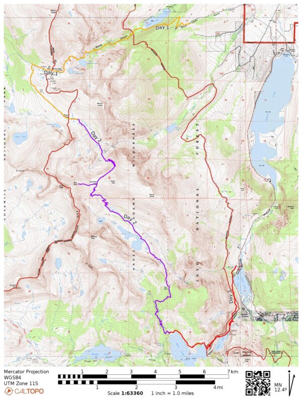
Our itinerary could be improved upon. Instead of camping at Parker Lakes and Gem Lake, I would camp at Lower Sardine Lake and then at the Alger Lakes. This decreases the elevation gain on the first day, mitigating some of the AMS risks, but also requires a longer hike-out on the last day.
Permits & Regulations: Permits are required for overnight trips in Inyo National Forest; these can be reserved online at Recreation.gov. Campfires are not permitted along much of this route, and food and trash must be stored in bear-proof containers. Stock is generally not recommended on these trails. Finally, remember to leave no trace!
Resources: Visit the Bloody Canyon and Rush Creek trailhead websites for up-to-date information on current conditions and closures. These websites also include lists of restrictions for the nearby wilderness areas; see also the website for the Ansel Adams Wilderness.
Bloody Canyon
4 July 2025 | 8 mi | +3800 / -600 ft | View on Map
Shannon and I leave LA at 7 AM, with CK and Kenza just a few minutes behind us. We all stop in Bishop at the Great Basin Bakery to pick up some sandwiches and then finish the drive to Rush Creek where we’ll leave my car. We arrive at 12:30, eat lunch, and then all pile into CK’s car. He drives us up the rocky forest service road 1S23, through Sawmill Canyon to the Bloody Canyon trailhead. There we finish packing our bags, slather on sunscreen, use the pit latrine, and then hit the trail at about 2:15.
The trail climbs about 400 feet from the trailhead, only to lose all 400 of those feet descending to Walker Lake. It feels very unnecessary, but apparently the buildings and dock at the east end of the lake are private property and not accessible to hikers. A brisk wind whips up waves on the lake and creates long strings of surf parallel to the wind direction; I’ve never seen anything like it!


Once we reach the lake shore the trail flattens out for a short distance and we walk through some truly idyllic forest. Lush, green grass, dappled light, a gurgling creek, towering pines and whispering aspens… it’s beautiful. This land was all slated to be sold off to private owners as part of the “Big Beautiful Bill,” but has been preserved as public land (for now) thanks to backlash from the outdoor community. Thank goodness for that!


")
After a brief, flat stroll through the woods the trail begins a steep uphill climb paralleling Walker Creek. It continues to be beautiful, with all kinds of different wildflowers and views of the rushing water, but it’s decidedly warmer. Thankfully, the brisk wind persists and keeps us cool as we struggle up the canyon.


We stop for a snack break at Lower Sardine Lake at 5 PM. It’s very windy and a bit chilly, but I really need some calories and the lake is beautiful with its green bushes and red rocks. We sit for a while and then continue around the lake. I’m surprised to find irises growing near an inlet creek! I’m less surprised but no less happy to find patches of pink and yellow sierra columbines a little further up the trail, as well as lupine and elephant’s heads. We pass a few descending day hikers on the far side of the lake and then spot a few campers when we reach Upper Sardine Lake. We, however, keep walking.
The terrain becomes significantly more rocky as we ascend. Many years ago, before wagon roads were built, this route was used to cross the Sierra by native people and sheepherders. However, the rugged, rocky ground often injured the livestock, which is how the canyon earned its name. Thankfully, it’s not at a threat to our feet or ankles; the trail is well-traveled and not technical.


My rough plan for the day is to hike over Parker Pass and camp near one of the small lakes on its east side. On paper, it doesn’t look too bad: 8 miles, 4000 feet of gain, climbing from 7900 feet at the trailhead to 11,100 feet at Parker Pass. In reality, it makes for a very late evening when you don’t start walking until 2 PM. It’s also a bit on the high side for a group of people that live near sea level.
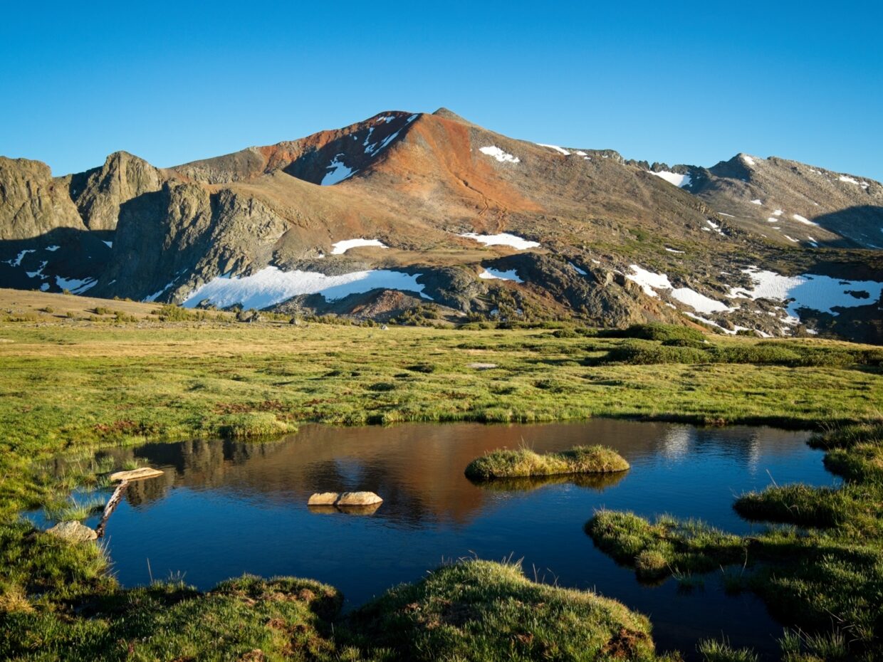
We reach Mono Pass (10,595 ft) at 6:45 PM. It’s a very gentle pass, without a sign I’d have no idea where the high point is. Rolling hills, small lakes, and trees are scattered around a vast, green plateau; we even see a family of deer with several young fawns! The trail levels off as we stroll through this beautiful landscape and I thoroughly enjoy looking around.


We soon branch off from the Bloody Canyon / Mono Pass trail and begin a short uphill hike. The trail levels off again about a mile from Parker Pass and we enjoy a scenic walk through an alpine meadow at golden hour! I’m very tired and have begun fueling entirely with gummy worms, but we’re almost to camp – just a few more minutes of walking.


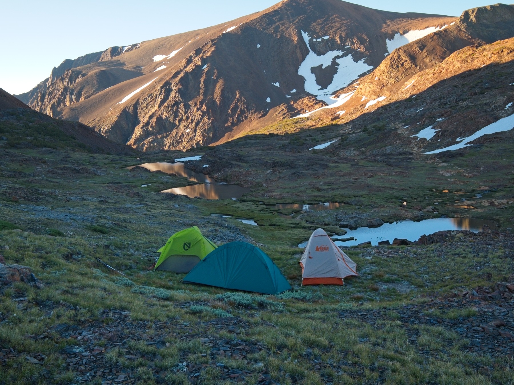
The sun is fully setting behind the mountains when we arrive at Parker Pass at 8:10. Our shadows stretch waaaaay into the distance as we stare at the sign marking the high point. We’re all exhausted and shuffle down the other side into the shade to look for a campsite. There aren’t as many options as I’d hoped, but we find a suitably dry, flat spot within a few minutes and get started setting up our tents.


Alpenglow plays across the mountains as we finish making camp and we cook and eat dinner in the dark. Between the high altitude (about 11,000 feet) and the long, effort-filled evening, I’ve completely lost my appetite. Shannon, Kenza, and CK aren’t feeling particularly well either, but Kenza is feeling the worst. Her symptoms could point to anything from a bad sandwich to the flu to altitude sickness. For now, she tries to hydrate and get some rest in the hopes that she’ll feel better in the morning.
Parker Pass to Gem Pass
5 July 2025 | 10.5 mi | +2500 / -4400 ft | View on Map
Sunrise comes early this time of year – between 5 and 6 AM – and I’m up by 6:30. To my chagrin, I haven’t slept much at all, but that’s often how my body reacts to the first night camping. My appetite has returned though, so my body has acclimated at least a little bit to the altitude. Shannon and I have breakfast and then wander up the ridge of Mount Lewis to see if the views are any good while Kenza gets a little extra sleep. It turns out to be more of a plateau than a ridge, and we turn back before making it to the far side.
Kenza is up when we return from the walk, but she isn’t feeling any better than last night. Worse, really – her nausea has intensified and she’s unable to keep food down. She decides the best thing to do is to turn back; it’s mostly downhill and a much easier endeavor than continuing up to Koip Peak Pass and over to Gem Lake. CK volunteers to go back with her; they can take his car back to civilization while Shannon and I hike back to my car. We part ways at about 10:30. I’m sad to see them go, I was looking forward to two more days of hiking with them, but hiking out is definitely the right call.


Shannon and I head down the trail from camp at 10:30, passing through the lakes and rocks. There are plenty of wildflowers here too, though they’re smaller and closer to the ground. Directly ahead is the first challenge of the day: a wall of switchbacks ascending 1000 feet up the northwest face of Parker Peak. They’re gentler than they look from a distance, and hiking up them is a pleasant enough experience, particularly with the expansive views of the lake basin we camped in and some nice views of Mono Lake out in the valley. We even find a bunch of sky pilots blooming near the top of the trail!


By the time we reach Koip Peak Pass at 12:45, I’m very hungry and ready for a lunch break. We stop to eat and admire the new vista looking south: Alger Lakes, Blacktop Mountain, and the Ritter Range! After a brief rest we hike up the talus to Koip Peak, one of the many mountains on the SPS to-do list. It’s not a difficult climb at all, but I’m tired from the lack of sleep. Since we’re not in a hurry, Shannon and I take a longer, 45-minute break at the summit before returning down the slope to the pass. We meet a bunch of day hikers who have come out to bag this peak, many of them hiking from their campsites at Upper Sardine Lake, but also several from Dana Meadows and the Tioga Pass Road.


The descent from Koip Peak Pass to Alger Lakes is surprisingly rugged. Up until now, we’ve enjoyed well-traveled trails that are clearly marked and easy to follow. Here, in the loose scree on the south side of the pass, the trail occasionally disappears entirely and many sections are so loose that it’s difficult to stay on “the trail.” It’s in much worse shape than the switchbacks we ascended on the north side. We pass a few brave people with day-hiking bags climbing up to the pass and wonder where they’re headed tonight. It’s already nearly 4 PM, and we’re nowhere near a trailhead.
 up here too")


At the bottom of the switchbacks we step into lush green meadows with myriad creeks appearing from the base of the scree. It’s beautiful, and the hiking is easy to boot. The trail is faint in places, but a glance at the map reveals that as long as we hike toward the foot of the Alger Lakes we’ll be heading in the right direction. Shannon and I are both tired so we take a short break at one of the lakes. We jump into the cold water to cool down; the plunge clears my head and wakes me up.


The trail is more defined as we walk away from Alger Lakes — it’s a beautiful area and I’d guess a popular spot to camp, although we haven’t seen a single person down here. After a very short climb, we begin a long descent to Gem Pass. The trail winds through some beautiful ponds and wooded benches before traversing across the side of the upper Alger Creek Canyon. I get some patchy cell service and recieve messages from CK and Kenza to say that they’ve made it down to the trailhead and that Kenza felt much better once she descended below 9500 feet. It’s a relief to hear that she’s doing better!


Gem Pass itself is pretty unremarkable: a wide, forested saddle with a glimpse of the Ritter Range through the trees. We follow a dusty trail, descending below 10,000 feet for the first time since yesterday afternoon. The evening light filtering through the pines is pretty, but the tranquility of the walk is ruined by hoards of mosquitoes. We pull out head nets and hurry down the trail, eager to get to camp and relax for the evening.
After a tiring 1500-foot descent, we arrive at Gem Lake at 7 PM. A spacious campsite right next to the trail and an inlet creek is completely empty, so we claim it for ourselves. We cook dinner and then wander up to a rock with a view of the lake to eat. The mosquitoes are a little less annoying here than they were up in the woods, though there are still plenty buzzing around. We don’t see a single other person the rest of the evening.
Rush Creek
6 July 2025 | 4.75 mi | +300 / -800 ft | View on Map
With only a handful of miles to hike out today, Shannon and I take our sweet time getting up, eating breakfast, and packing up camp. We start hiking at 9 AM and enjoy a relaxed stroll around the north side of the lake, walking through all kinds of trees, from the usual pines to large junipers and even a few patches of aspens.
As we reach the end of the lake, a wide, multiple-arch dam comes into view. I’m surprised to see that kind of infrastructure all the way up here in the wilderness! I have so many questions, many of which are answered on the internet when I get home. The dam is one of three (there’s another up on Waugh Lake, and one further down on Agnew Lake) that regulate flow to a hydroelectric station down near the town of June Lake. The Mono Basin Clearinghouse has a trove of related documents if you want to read more!


The trail descends from Gem Lake down to Agnew Lake, which sports another dam and a mysterious dock floating in the middle of the water. We step over several large pipes that feed the hydroelectric station and stare out at inclined rail tracks leading from Agnew Lake up to the Gem Lake dam. What an interesting area!
Further down the trail, below the Agnew Lake dam, we actually cross the rail line a few times. It doesn’t look like it’s used any more, but it’s fascinating to think about riding a little car up and down the mountain (see documentary | website). Besides the old rail line, it’s a beautiful hike! Wildflowers dot the hillside, and there’s a wispy waterfall tumbling down the rocks not far from the trail. We pass several hikers and groups of backpackers on the way down; it’s odd to me that we’re only now seeing people; I would have expected all sorts of campers up at the lake last night since it’s a holiday weekend.


The hike out to Silver Lake feels long, but it’s really not very far or very much elevation loss. It is quite hot though, and I’m very sweaty by the time we reach the car. Shannon and I jump in the water, annoying several nearby anglers. We don’t stay long, just long enough to cool down and wash some of the sweat off before we begin the long drive back to LA.