My plan for this trip was to climb Polemonium Peak, one of California’s 14ers, and the last one on my list. However, between a delayed start and significantly more snow on the ground than I had anticipated, we didn’t make it to the peak. We still had an amazing time though! Early October is perhaps my absolute favorite time to be in the Sierra, and this weekend did not disappoint. We got all the beauty of peak fall color combined with the magic of early snow.
Trip Planning
Specs: 17.7 mi | +/-4400 ft | 2 days, 2 nights
Difficulty: Class 2 [ratings]
Location: Inyo National Forest and Sequoia-Kings Canyon National Park, California | Home of Eastern Mono and Northern Paiute peoples | View on Map
Route: Hike from South Lake to Bishop Pass and then follow a cross-country route to Thunderbolt Col, staying on the easy, grassy ramps and benches as long as you can.
Permits & Regulations: Permits are required for overnight trips; Inyo National Forest controls the permits for the Bishop Pass Trail. Campfires are prohibited along most of this route, and food must be stored appropriately to keep the bears out. As always, make sure you leave no trace out there!
Resources: The Bishop Pass Trail page is a convenient resource for information about the trail and current conditions.
Golden Afternoon
Saturday, 4 Oct, 2025 | 4 mi | +1600 / -200 ft | View on Map
Shannon and I drive up from LA to Bishop, arriving at about 1:00 for a delicious lunch at the Great Basin Bakery. We then take the road up to South Lake and gape at all of the brilliantly-colored aspen trees in the canyon. I’d love to spend the entire afternoon up here, looking for composures, snapping photos, etc., but we do have to hike this afternoon. Note to future self: make plans for autumn photography up here!
The trailhead at South Lake is absolutely packed with cars and there are no open spots in the overnight parking area, so we park a little ways down the road and then walk back to the trailhead. After a quick re-shuffling of gear we’re on our way! There’s a small collection of aspen trees right on the shore of South Lake, lining the trail, and we spend a few minutes there admiring the color. There’s also a fresh coat of snow on the mountains above the lake, courtesy of some early storms that rolled through this week. The forecasts said to expect about an inch of snow accumulation and it’s been sunny since, so I’m not worried about having to walk through too much snow.


The trail quickly climbs up above South Lake and disappears into the woods. I can feel the altitude immediately as we hike uphill – a little light-headedness and that burning feeling in my legs… We are at 10,000 feet, so it’s warranted, and I haven’t spent much time at altitude recently. Higher up the trail, we begin to see patches of snow, and then mostly snow, hinting that more than an inch fell this week. The trail remains mostly dry, though, and the lingering snow is gorgeous, its cold blues contrasting against the warm autumn foliage.
We soon reach the foot of Long Lake and get some incredible views of the snow-dusted mountains reflected in the water. Dozens of hikers pass us, heading back to the trailhead, but we see a few adventurous folks heading deeper into the wilderness, like us. I’d be day-hiking here too if I lived close enough to pop up for the afternoon!


The trail winds along the east shore of Long Lake and we enjoy the warm afternoon sun. It’s a pretty easy walk with relatively little elevation gain, and the scenery is spectacular! Of all the times I’ve been up here – Oct 2022 for Mount Sill and Oct 2023 for the Thunderbolt to North Palisade Traverse – this takes the cake for most beautiful.


Shannon and I hike up to Saddlerock Lake and set up camp on a small hill overlooking the water. The sun soon dips below the mountains to the west, casting our campsite into shadow and bringing on a quick decline in the temperature. We bundle up and make dinner – a mushroom udon noodle soup Shannon put together. It’s a delicious, hot meal, perfect for this snowy, mountain wilderness. Once we’re done cleaning up, we escape from the cold into our warm sleeping bags and call it a night.


Fresh Snow at Altitude
Sunday, 5 Oct, 2025 | 9.7 mi | +/- 2600 ft | View on Map
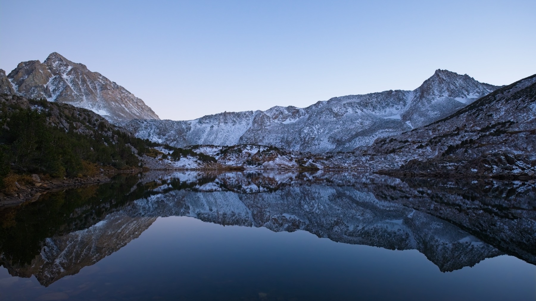
It’s quite cold this morning – definitely below freezing. We wake up to crystal clear skies and absolutely no wind, which makes Saddlerock Lake a perfect mirror. By 7:45 we’re on the trail, hiking toward Bishop Pass. Our plan for the day is to hike over the pass and then trek cross-country over Thunderbolt Col to the foot of Polemonium Peak, climb the mountain, and return to camp. We’ve got about 11 hours until the sun goes down, and the round-trip stats are 10 miles and about 4400 feet of elevation gain. With light packs that should be no problem!
The trail up Bishop Pass is almost completely covered in snow and is frozen solid this morning, but it’s not particularly slippery; we’re able to walk up the trail without extra traction. We reach the top at 9:20, having covered about 2 miles, and set off cross-country. The sun hasn’t peaked over the mountains yet, so it’s still frosty in upper Dusy Basin. We soon discover that much of the talus is coated in ice, making rock-hopping over the snow a precarious business. The snow is much more than an inch deep too – in some places it covers my shoe entirely.
After a short pause at a small lake we head downhill and into the morning sun. We’re soon free of frosted talus (the sun quickly melts that ice) but not of ankle-deep snow. I lead Shannon along the benches and ramps that criss-cross upper Dusy Basin, trying to avoid the snow and keep our feet dry, but we can’t avoid it completely. As we near Thunderbolt Col, the snow coverage increases and the route-finding gets trickier and slower on the steeper terrain. Snow on flat ground is one thing, but snow (and snow-covered ice) on slanted granite slabs is another.


By the time we reach the snowy, talus slopes below Thunderbolt Col, it’s already 11:00. I begin to do the mental math and realize we’re not going to make it to Polemonium Peak if we want to be back to camp by dark (and we do). We have, at most, 5 hours available to get from here to the summit and back, and that’s not enough time to cover another mile of talus, ascend 2000 feet, do some low-5th class rock climbing, and then reverse the entire sequence.
Shannon and I talk and decide to hike up to Thunderbolt Col anyway – it’s a nice view on the other side, and an area most hikers don’t ever get to see – and then we’ll turn back. So we hike on up the talus, which is much more difficult than I remember. The snow on and between the rocks slows us down considerably, but the large blocks are also hard to navigate even when they’re dry. We reach Thunderbolt Col right around noon and take a long break to rest and admire the views. I’m kicking myself for not doing more of this math last night when we already knew about the snow, but there’s not much we could have done except hike longer last night.


After a long break at Thunderbolt Col, we carefully descend the talus and strike out across upper Dusy Basin toward Bishop Pass. Mount Agassiz looms over the pass there and is a pretty simple climb – just 2000 feet of class 2 talus – so I’m holding out hope that we can snag it on the way back. Thanks to the persistent sunshine, the ground is much softer and wetter than this morning, and dozens of small creeks gurgle through the turf.
The final half mile up to Bishop Pass is uphill and kicks my butt. Even with a light pack, I’m struggling to catch my breath while walking. Shannon and I hike to the foot of the slope we would ascend and deliberate. It’s only 3 PM, so we have time for the climb. But we’re both exhausted, surprisingly so given how few miles we’ve covered today, and we decide it’ll be a sufferfest and we’d rather return to camp.


So we return to the Bishop Pass trail and hike back toward camp. The snow thins out as we descend, though the switchbacks below the pass are still completely covered. We reach Saddlerock Lake a little after 4 PM and enjoy a few hours of relaxing, reading, and lounging around camp. We briefly consider jumping in the lake but settle for soaking our feet when the water is (predictably) ice-cold.
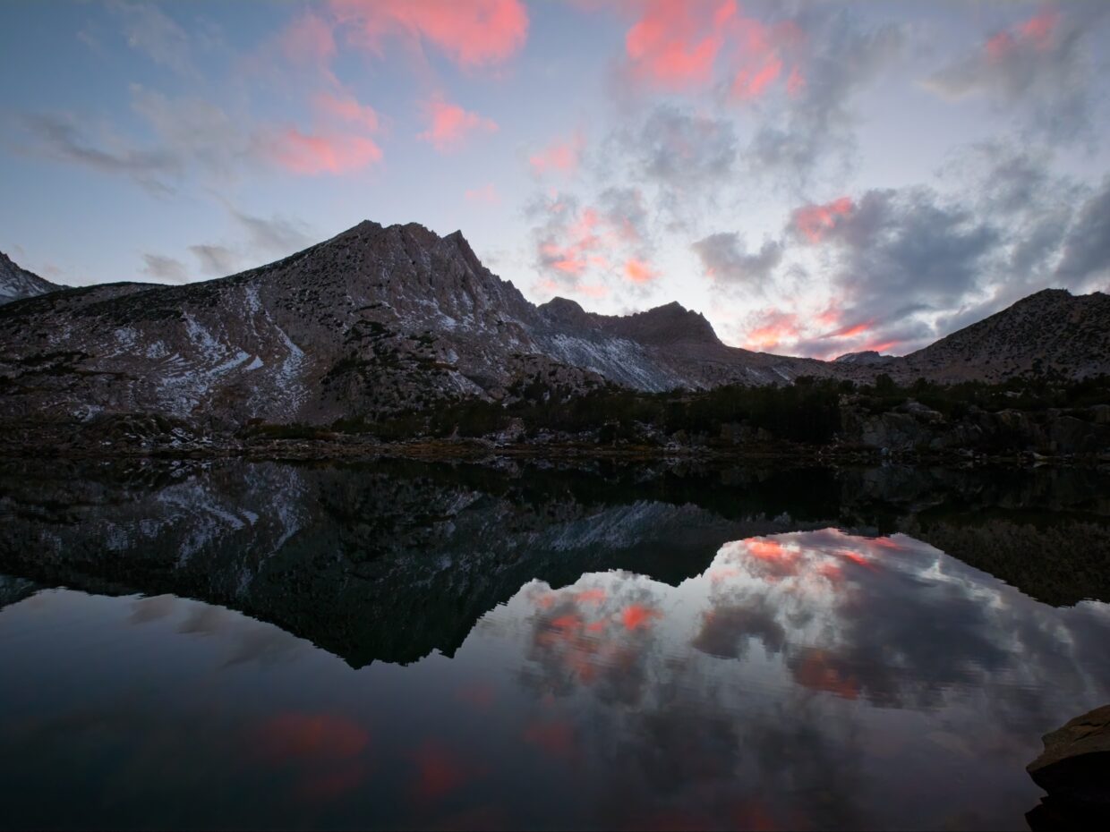
Scattered clouds overhead promise a colorful sunset, and I grab my camera and wander around the lakeshore to snap some photos. The lighting doesn’t disappoint and we’re treated to gorgeous cotton-ball clouds over the glassy lake! Once the sun has set we eat dinner (tortilla soup), clean up camp, and spend an hour or two warm in our sleeping bags before going to sleep.

Pre-Dawn Departure
Monday, 6 Oct, 2025 | 4 mi | +200 / -1600 ft | View on Map
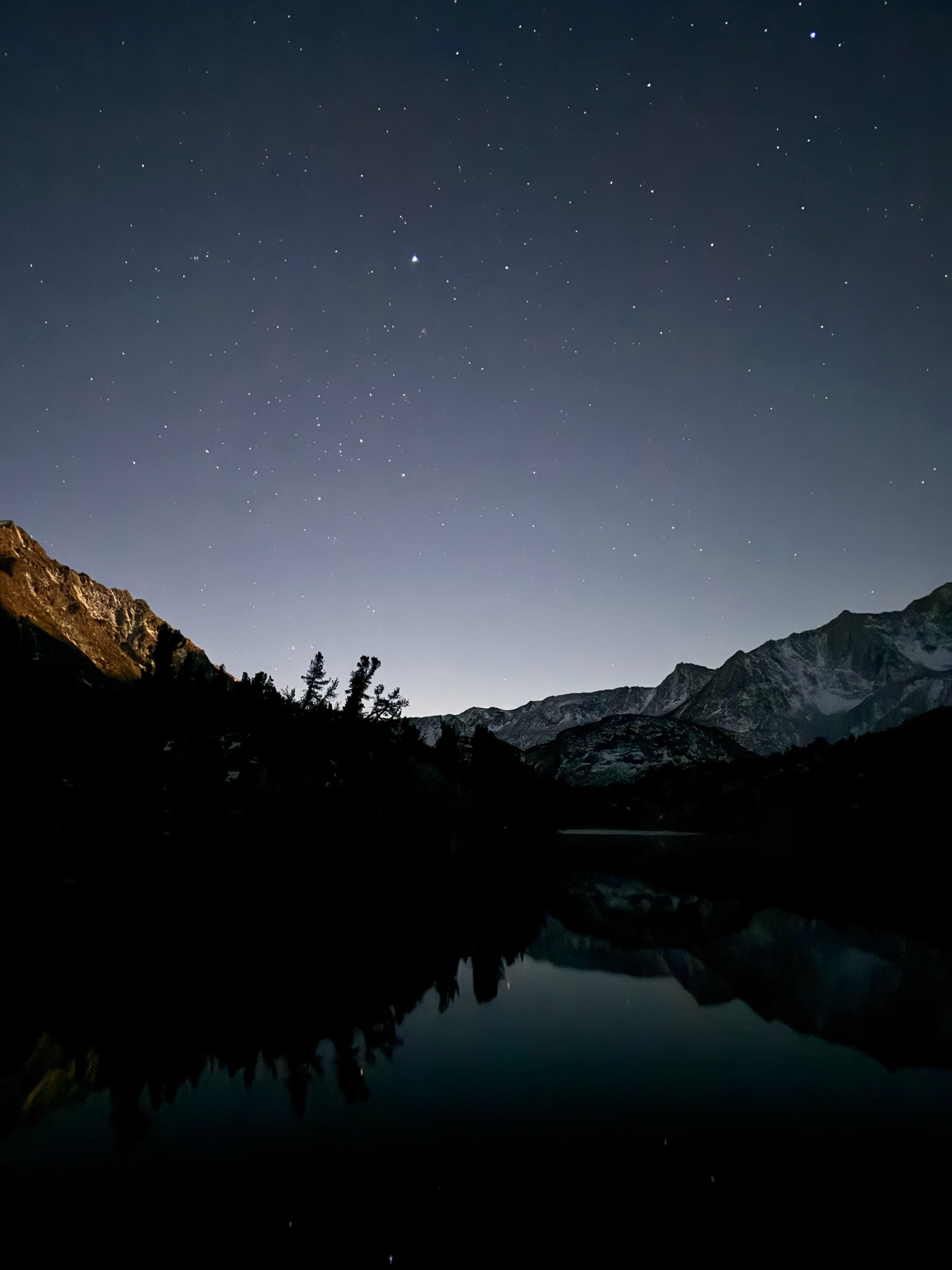
Shannon and I both have work today and are up well before dawn. We break down camp and hit the trail in the dark with headlamps lighting the way. The sky is clear this morning, and the lakes reflect stars in their still waters. It’s really beautiful, and not terribly cold; a lovely “alpine start.”
By the time we reach South Lake, the sun is just rising and the peaks across the lake are tipped in orange and pink. Shannon notices that the apsen trees have changed a lot since Saturday: the green leaves are now gold and the gold leaves are now brown and falling. I didn’t realize they changed so quickly, so I’m glad we were here to see them a few days ago!


We’re soon back at the trailhead where we find our car covered in frost. After a little windshield scraping we pile in and drive down to Bishop for coffee and a hot breakfast.