I hadn’t thought much about Mount Olympus until Craig mentioned he wanted to climb it. At 7,973 feet above sea level, it isn’t particularly tall, nor is it visible from far way like Baker, Rainier, and the other stratovolcanoes. But summiting Olympus is a great adventure! You begin in a temperate rainforest, gradually climb up into montane forest, and end up in alpine meadows and glaciers. It’s no easy hike either; the long approach and varied ecosystems mean you’ll need to carry a lot of gear for a lot of miles. Josh, Cody, and Craig joined me on this one and we had a great trip.
Trip Planning
Specs: 47 mi | +/- 11,000 ft | 4 days, 3 nights
Difficulty: Class 5.4 [ratings] – The vast majority of the hike and climb is class 1, only the summit block is 5.4
Location: Olympic National Park, Washington | Home of Hoh, Quileute, Cayuse, Umatilla, and Walla Walla peoples | View on Map
Route: Begin on the Hoh River Trail and follow it up to Glacier Meadows. From there, continue up the well-traveled path to the top of the lateral moraine. A cairn-marked trail follows the top of the moraine for a short while and then drops down to the Blue Glacier. The path across the glacier will vary with the season and conditions; see SummitPost for descriptions of the various options.
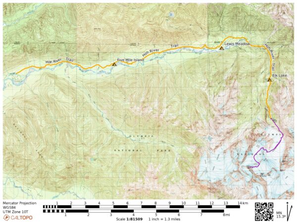
Permits & Regulations: Permits are required for overnight trips on the Hoh River Trail and on Mount Olympus. Many of the campsites have bear wires, but some do not (none of the dispersed camping areas do), so you may need a bear canister.
You’ll need a pass to enter the park, but once inside the parking is free. Note that the line to enter the park can be very long (hundreds of cars) and it’s not unheard of for people to wait hours to enter the park. For what it’s worth, we didn’t have to wait long on a Friday afternoon.
Resources: For general information, visit the Hoh River Trail page on the Olympic National Park website. The dedicated Wilderness Backpacking page also has lots of great details about planning trips in this area.
Arrival in Seattle
Friday, 18 July 2025 | 5.3 mi | +500 / -300 ft | View on Map
I meet Josh and Cody in Seattle this morning (I flew in last night) and together we drive to the airport to pick Craig up at 10:30. Then it’s off to the Olympic Peninsula! We stop at an REI along the way to pick up a few supplies and then slowly make our way through the dense traffic on I-5; there are fewer cars on highway 101, thankfully. In Aberdeen we eat lunch at a sandwich shop and can’t resist buying several different types of cookies, only some of which make it to the trailhead.
We arrive at Olympic National Park at about 4 PM. There isn’t much of a line at the gate and we’re able to park quickly. Craig and I have some re-packing to do, and we distribute group gear like the rope, pickets, ice screws, and the trad rack.
Once we’re all packed up we walk over to the Hoh River Trailhead and begin the hike. We walk through dozens of people on the nature trails before reaching the less-crowded single-track path leading into the forest. I quickly fall behind the group as I stop to take photos of the rainforest: the massive trees, the moss, the ferns… it’s beautiful!


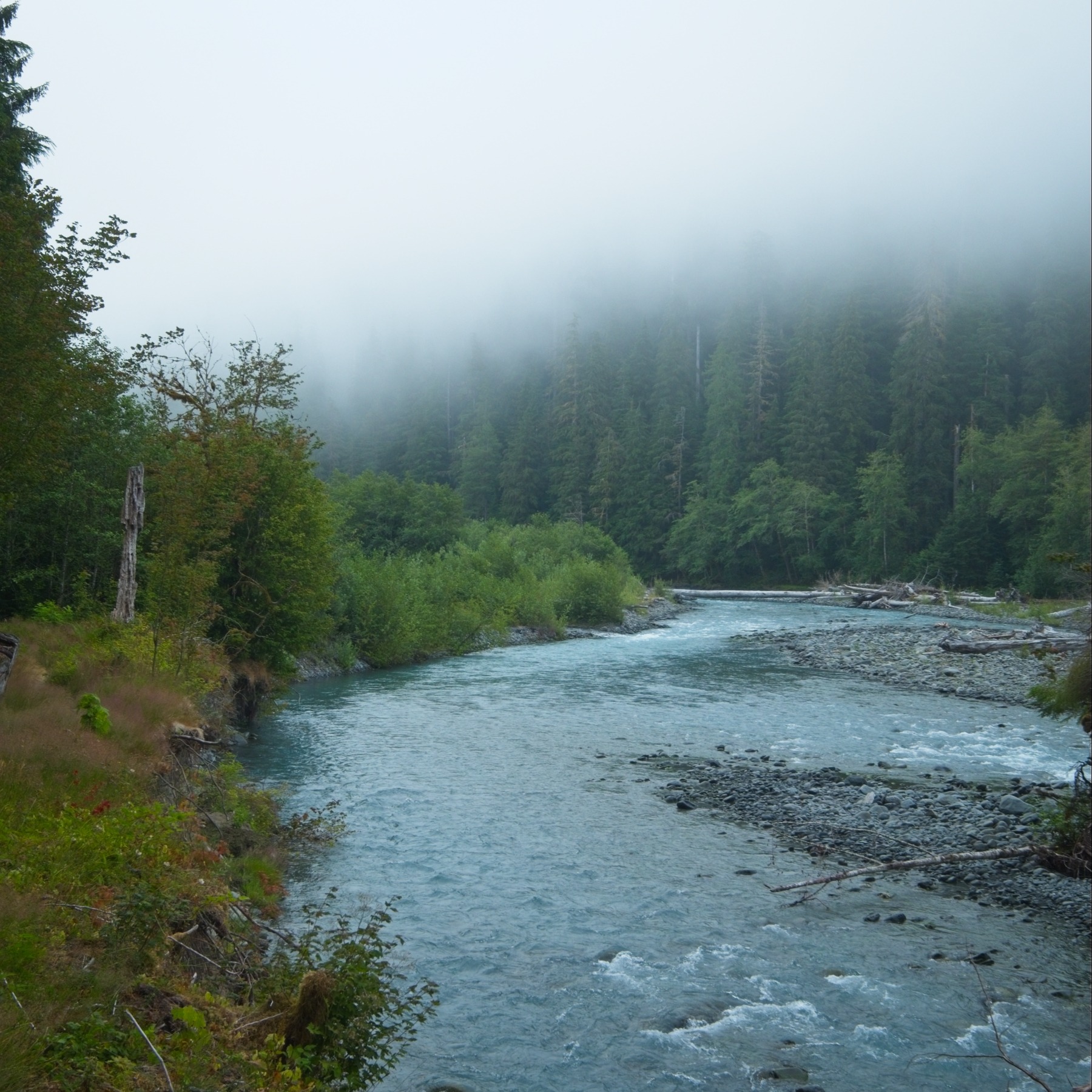
I find Craig, Cody, and Josh again at a small creek that runs into the larger Hoh River. We hang out for a few minutes, munching on snacks and checking out the water. The entire river is light blue with glacial chalk, and the stones at the rivers edge are coated in a thin layer of the stuff. Standing here in the warm, humid rainforest it’s strange to imagine all that ice 15 miles up the trail.


It only takes us two hours to reach the Five Mile Island campsite, appropriately located about 5 miles from the trailhead. We scout around in search of a spot for our tents; most of the shaded sites are already occupied, but there’s plenty of space on a sandy beach beside the river so we pitch our tents there. We cook dinner and chat for a while. Although we haven’t hiked far at all, I’m plenty tired from the day of travel and other mountain adventures earlier in the week. We don’t stay up much past sunset.
Staging at Elk Lake
Saturday, 19 July 2025 | 11.2 mi | +2600 / -700 ft | View on Map
We don’t have very many miles to cover today, so we all sleep in. I get up at about 8 and eat breakfast with Josh, Cody, and Craig on the beach. We’re on our way by 9, easily walking down the flat trail and chatting. We’re still well within the rainforest and every living thing is covered in moss and other plants. The air is relatively cool thanks to overcast skies, but the humidity is high; even small inclines leave sweat on my forehead.


The trail winds through dense forest, open clearings, and skirts the river every once in a while, offering more expansive views of the surrounding mountains. We pass a trail maintenance crew hard at work at the junction with the trail that leads up to the Seven Lakes Basin and thank them for all their hard work.


About seven miles into the hike, the trail begins to climb in earnest. We reach a bridge over the Hoh River and are amazed to find ourselves standing above an incredibly narrow gorge – it must be at least a hundred feet to the bottom! After admiring the view for a few minutes, we continue upwards. The humidity is through the roof and I’m dripping sweat on the hike up. It’s very uncomfortable, but I stop to take breaks and admire the trees (they’re huge!) every once in a while.


We reach Elk Lake at 3 PM and check out the campsite. There are several open spots near the bear wire and the pit latrine, but the latrine is full and unusable, so being nearby is really more of a nuisance than an amenity. We end up picking a spot a little ways down the hill with no other nearby sites. We’ll be getting up very early tomorrow morning, so at least we won’t be disturbing neighbors.


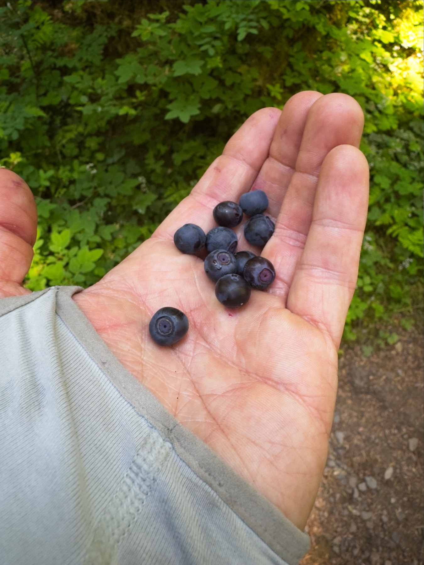
Once we’ve set up camp, we do some exploring around Elk Lake. Cody heads off around the south shore, while Craig, Josh, and I follow a very faint use trail around the north side of the lake. We were all hoping it would be a cold, alpine lake that we could swim in after sweating our way up the mountain, but it’s very marshy, definitely not a good swimming hole. As we’re exploring around the lake we find several undisturbed huckleberry bushes and enjoy snacking on them!
When we return to camp we find an enthusiastic group of 5 young mountaineers hanging out at the shelter near our campsite. I chat with them for a moment and then go back to camp; we later hear them singing loudly when they leave the shelter and resume hiking to Glacier Meadows. We spend the rest of the evening relaxing in preparation for tomorrow’s big day!
Mount Olympus
Sunday, 20 July 2025 | 19.4 mi | +7200 / -8900 ft | View on Map
My alarm wakes me up at 2:00 and I groggily roll out of my sleeping bag. I did get nearly 6 hours of sleep, so I’m feeling ok despite the early hour. After eating a quick breakfast and stuffing snacks into my backpack, I’m ready to go. We walk out of camp at 2:45 and follow the trail from Elk Lake toward Glacier Meadows. We gain altitude quickly, but the cool night air and lighter packs makes it much more bearable than the warm, humid conditions yesterday afternoon.
The miles flow by in the dark and we soon reach the infamous cable ladder that allows us to descend a steep, loose slope. We take turns, allowing each person to descend at least halfway down the ladder before the next person gets on. It’s a strange feeling, climbing down a ladder in the dark. I can’t see the bottom of the slope, I’m just putting one foot in front of the other. A few of the rungs are broken and one is missing, requiring some extra flexibility to get my foot on the next one down.
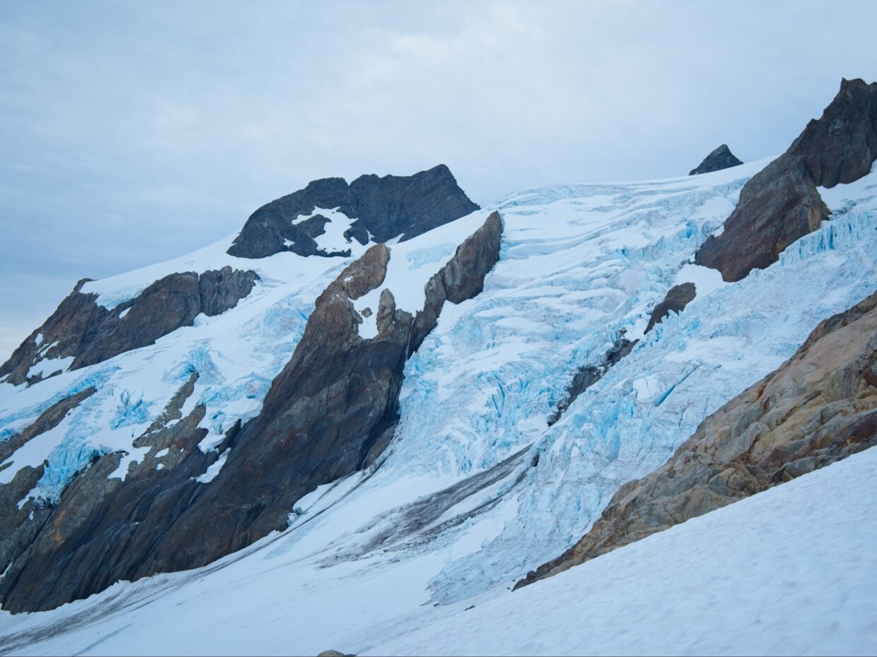
We’re soon all down the ladder and we continue up the trail to Glacier Meadows. We stop to use the privy and refill water bottles from the nearby stream before following the trail through camp, still gaining altitude. I’m happy to spot wildflowers underfoot, it’ll be great to see this area in the daylight! We top out on a lateral moraine of the Blue Glacier at about 4:45, having climbed 2500 feet from camp. I curse when I see that the glacier itself is several hundred feet below the moraine; I was really hoping it would be more of a “step from the moraine to the glacier” kind of situation. We spot a string of five lights on the glacier below — likely the group of five we ran into yesterday — and one other pair of climbers on the far side of the glacier. I was worried we would be at the back of a conga line of many climbers since we started from lower on the trail than most folks but it seems like we’ll only have two parties ahead of us.
After admiring the glacier in the pre-dawn light for a few minutes, we begin the tedious descent down the lateral moraine. It’s dirty and loose, as you would expect from glacial till. Thankfully, there’s a well established path and we don’t have to mess around with boulder-hopping on the wobbly talus. Once we reach the glacier itself, we walk a little ways on hard snow and piles of rock to reach the blue ice and stop to rope up there. A cold wind blows down the glacier, and I shiver, even in my warm layers. We all don crampons and harnesses, pull out ice axes, and pee one last time before tying into the rope.


Dawn alpenglow floods the upper ridge of Mount Olympus as we set out across the glacier. It’s a beautiful mix of colors, with pinks and oranges up high and blues down here. Josh leads the rope team and sets a quick pace across the ice. We step across myriad rivulets of gurgling melt water and over a few stomach-clenching crevasses, but it’s generally a flat, easy walk.
We reach the opposite side of the lower glacier at about 6:20 and take a break for a few minutes to eat snacks and admire the impressive ice formations flowing down from the upper mountain. Then it’s back on the rope and up the slope. We wind up ribbons of snow and over bands of rocks, following the many boot prints in the snow. It’s comfortably cool this morning (well above freezing) and waterfalls pour down the rock faces, carrying glacial melt to the river far below. We needn’t have filled our water bottles back at Glacier Meadows, we could have done it up here!


We soon reach a steeper slope, the apron of “Snow Dome,” an expansive, snowy plateau about 1000 feet below the summit. Hiking up the slope is easy enough although the person that set the boot track must have been tall; the steps are uncomfortably far apart! We take another short break at the top of the steep section to eat more snacks and admire the view. The true summit is the “West Peak” of Mount Olympus, with two other sub-peaks, the Middle and East Peaks, to the side. There are several routes to the summit: the “Autobahn” and “4th of July” routes take a relatively direct line from Snow Dome to the summit. Those are inaccessible now since the snow bridges that spanned the bergschrund and several enormous crevasses have melted. We’ll instead follow the “Cyrstal Pass” route, a less direction option that winds around to the east through a gap in the ridge.


After a short break, we continue across Snow Dome, again following the established boot track. It’s turned into a lovely day with mostly cloudy skies, very little wind, and relatively warm temps. The snow is firmer up here than it was down lower, and we make good time across the plateau. The path to Crystal Path winds around a few crevasses but is otherwise very straightforward. Once we cross to the other side of the ridge, the wind picks up a little and I pull on an extra layer. The trail also begins to climb again, reducing that 1000-foot gap between us and the summit.
We catch up with the five-person team as we’re hiking over the false summit that sits immediately east of the West Peak. There’s no snow on the false summit, just loose scree, so we wait for them to descend down the other side and out of the fall-line before we make our way down the loose rocks. It’s always such a joy, walking through scree with crampons on.
From the false summit we can see that the group of two we spotted from the moraine this morning is climbing the 5.4 rock route to the summit; the leader isn’t too far up the climb yet, and the 5-person group is hiking up the final snow slope to reach the base of the rock climb. With seven people in front of us, we decide to take a break where we are, hoping for some shelter from the cold wind. I grow frustrated as we wait for 45 minutes while the two-person team slowly makes their way up the rock. We hike over to the base of the climb and then wait another hour for the five-person team to complete the climb.
Josh leads the route, making quick work of it; he’s up at the sling anchor within a few minutes! Cody and I simul-climb the route on a fixed line using micro traxion devices to capture our progress, and then Craig follows on belay (we only have two of the microtrax). It’s a fun little climb with an easy but exposed crux about halfway up the climb. I particularly enjoy the hand jams and even a couple foot jams (it’s hard to pull those boots out of a jam though!). We’re all up the climb in about 25 minutes and eagerly walk up the final few feet to the summit, arriving at 10:45.


We take our sweet time on the summit while the group of 5 rappel back down the mountain. The views are shrouded in clouds today, but we can make out Mount Rainer far off to the east! Mount Baker is also visible in the distance. After about 45 minutes, we’re clear to rappel ourselves and we head back down.


The sun finally appears in full at noon as we pack up the climbing gear just below the summit. The light reflects off of every surface as we descend down the glacier and I’m soon dripping sweat. Hiking down the snow goes faster than the ascent, even though it feels very long; it only takes us two hours to reach the lower glacier.


We transition back to hiking shoes and stuff the rope, boots, and crampons back into our backpacks when we reach the lateral moraine. The climb up the loose rock isn’t as bad as I feared and we’re soon strolling across the top, giving brief summaries of the climb to several groups of campers that have hiked up to the moraine for a view. The descent from the moraine to Glacier Meadows is my favorite half hour of the trip so far. Dozens of different wildflower species are blooming; the meadows and hillsides are full of them!


We reach Glacier Meadows at about 3:45 PM and make a plan for the rest of the afternoon. Craig and I need to be to the airport tomorrow evening by about 5 PM, and the drive back to Seattle takes 4.5 hours, so we’ll need to be at the trailhead by noon. There are roughly 17.5 miles of trail between us and the trailhead. To avoid another very early morning, we’ll pack up our camping gear at Elk Lake (14.5 miles from the trailhead) and carry it downhill to Lewis Meadows, which is only 11 miles from the trailhead. This means we have a lot more walking to do today, but we have many hours of daylight left.
The hike back to Elk Lake goes quickly enough — it only takes an hour and 20 minutes — but we’re all pretty tired. We snack on salmonberries on the way down, and then sit down at camp for a little while to cook and eat dinner before we resume hiking.


Thankfully, the trail from Elk Lake to Lewis Meadow is almost exclusively downhill, so we don’t have to carry our heavy packs up many more hills. We all settle into our own paces for the hike; I loose sight of everyone else after 30 or 40 minutes and walk with my thoughts for an hour or two. It’s quiet and peaceful in the forest, so it’s a relatively pleasant walk, but the 5-mile, 1700-foot descent still wears me out. I’m relieved to arrive at Lewis Meadows at about 8 PM, ending a 17-hour day. I eat a little more food, repack some gear for the morning, and then pass out in the tent.


Hiking Out
Monday, 21 July 2025 | 11.1 mi | +700 / -1100 ft | View on Map
We’re up at a relatively luxurious hour of 6 AM this morning and on the trail by 7. The hiking today is “easy” and simple: a flat 11-mile walk back to the trailhead. We largely walk at our own paces again today, but we meet up about halfway through the hike near the Happy Four campsite for a short snack break. It’s funny how you can walk for an hour without seeing someone while they’re only a minute or two ahead of you.
We make it back in about 4 hours, averaging a speedy 3 miles-per-hour on the flat Hoh River Trail. I’m thoroughly worn out and happy to be back to the car. Craig and I repack our gear into our luggage and then we all drive over to a bend in the Hoh River and wade into the water to rinse off. It’s absolutely freezing! Only Josh is bold enough to submerge his whole body.
After washing up and changing into cleaner clothes we pile into the car and drive off to the nearest town, Forks, for a big meal. We find a taco truck and barbecue spot next door to each other and chow down. Then it’s back to Seattle! Traffic flows quickly and Craig and I make it to the airport with plenty of time to spare.
Jack 19 August 2025
Nice job!
Craig 20 August 2025
Great report on a really fun trip! The scenery up there is just amazing.
Craig Jagow 3 September 2025
Great job Andrew and nice report! Your report brought back fun memories of when I did it awhile back. Olympus is such an exceptional peak with the rain forest and glacier experience all rolled into one.
Andrew 8 September 2025 — Post Author
Thanks, Craig!