
I was introduced to the Mount Whitney Mountaineer’s Route by my friend and mountaineering partner, Kim, sometime last year, maybe as we were driving home after summiting Mount Baker. I’ve been atop Mt Whitney twice before, once on a serendipitous weekend trip and again at the end of the John Muir Trail. However, I just walked up a trail on both of those occasions; the mountaineering route requires off-trail navigation and snow travel skills, a much more interesting experience. So Kim, Josh, and I planned the trip for early spring to take advantage of the snow while hopefully experiencing warmer temperatures than the middle of the winter. Our luck was good and we had a great time on this hike with perfect weather!
Trip Planning
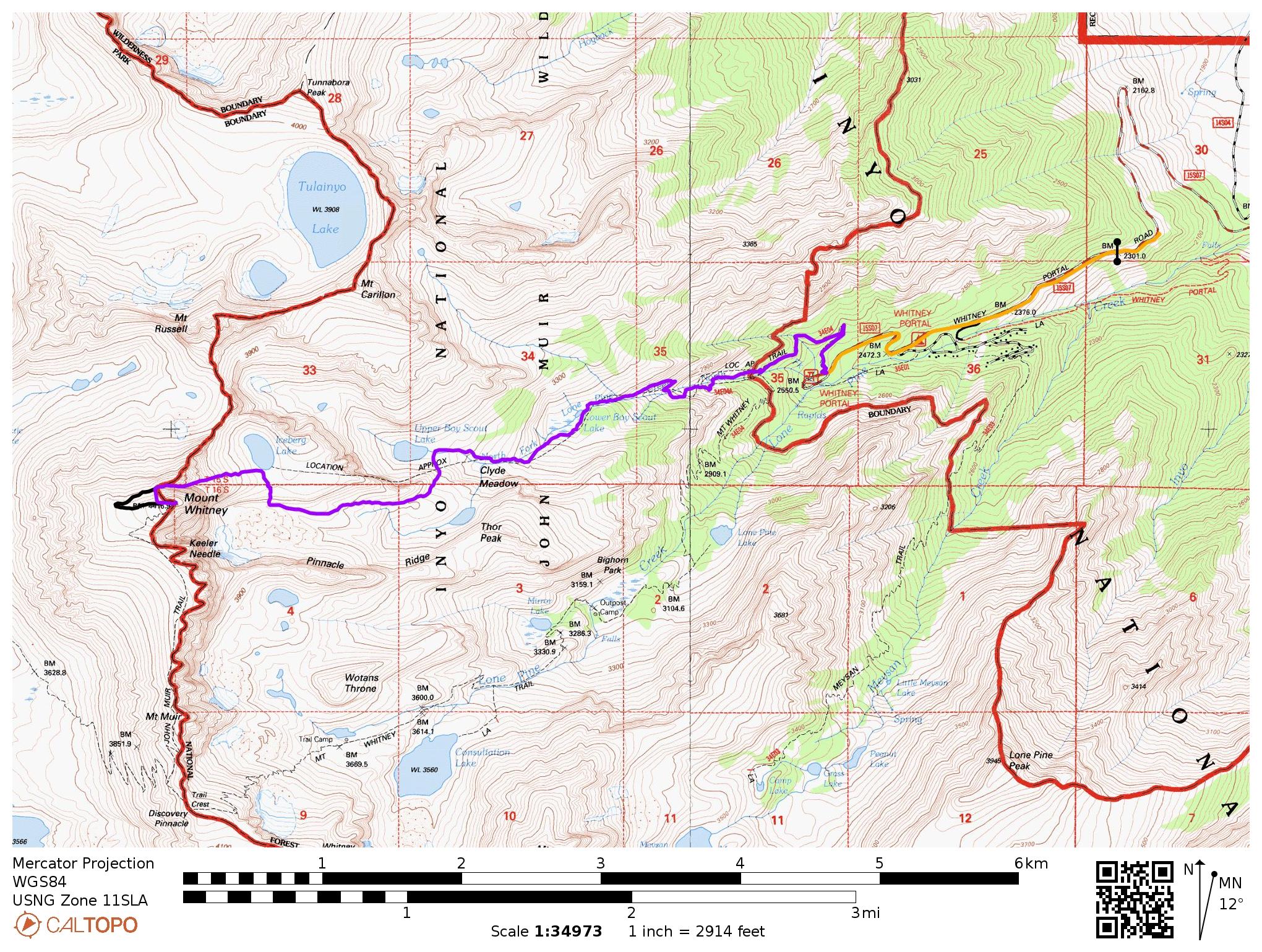
Specs: 13.1 mi | +/- 7200 ft | 1.5 days, 1 night
These specs include the road walk (1.87 mi, +950 ft one-way)
Difficulty: Class 3 [learn more] rock terrain and steep snow travel; avalanche risk is a serious consideration during the winter.
Location: Inyo National Forest | Home of the Tubatulabal, Eastern Mono/Monache, and Western Shoshone peoples | View on Map
Route: The Mountaineer’s Route is described in detail on SummitPost.
Permits & Regulations: A permit is required for day use and overnight use. For single-day trips, you’ll need a Mt. Whitney Zone Day Use Permit. Overnight trip permits are available via recreation.gov; select the North Fork of Lone Pine Creek (JM34) as your entry trailhead. You are required to pack out your solid waste in the Whitney Zone (the forest service provides wag bags) and bear cans are required if you’re staying overnight. For a full list of regulations, visit the Inyo National Forest website.
Resources: The SummitPost page has a great description of the route with pictures illustrating the key spots. The Mt. Whitney Facebook group has also been an invaluable source of recent trip reports and photos. I recommend the National Geographic topographic map of the Mt. Whitney area; Tom Harrison also publishes a nice map of the area.
To Upper Boy Scout Lake
09 April, 2021 | 4.6 mi | +4000 / -100 ft | View on Map
The Whitney Portal road is closed. A gap between the cones is wide enough to accommodate my little car, however, so I drive slowly past the signs and head up the steep mountain road. A short distance later I slow to a halt to wait for a grading tractor as it clears rockfall from the pavement. I wave to the driver as I squeeze past and continue up the road to another gate. This one is impassible, so we backtrack a few hundred yards and park in a sandy pull-off spot overlooking Lone Pine. Josh, Kim, and I hop out of the car and eat some lunch while admiring the valley below and the serrated profile of Mount Whitney in the distance. Once we’ve gathered our gear, Josh snaps a group photo using his phone and watch (how cool is that?) and we begin walking.

It’s about a mile and a half from the gate blocking the road to the trailhead. I’m soon sweating from the exertion of carrying a fully-loaded backpack on the hot pavement, but we’re all cheerful as we stride toward the mountain. The view from the road is phenomenal; Mount Whitney stands tall above a saddle in the closest ridgeline.

At the trailhead, we all weigh our packs on the scale (35-37 pounds for all of us!) before starting up the trail. I’m in the lead for the moment, so I try to set a relaxed pace; we have many hours of daylight and there’s no point in wearing ourselves out on the hike to our base camp! The first mile or so passes quickly on the well-groomed Mt. Whitney Trail and we soon reach the North Fork of Lone Pine Creek junction. Like most mountaineering paths, this one climbs steeply up the mountain, foregoing the gentle grade of the main trail.
A short distance up the trail we reach the first real obstacle: a series of granite slabs covered in snow and surrounded by a cliff on one side and thick willows on the other. The boot prints of previous hikers lead in every possible direction: through the willows, up the snow, onto the slabs… it’s difficult to decide which route is the fastest or safest, especially since none of us have hiked the mountaineer’s route before. I opt for the slabs, which prove to be slightly precarious. My brand new trail runners grip the irregularities in the granite, but Josh’s more weathered shoes slip and slide on the rock. Kim hikes in the snow beside the slabs, a less slippery route but one that is choked by willows. We eventually all make it past the slabs and quickly hurry past a frozen waterfall to avoid being struck by falling chunks.


After stepping through a bit more snow, we descend back into the willows, cross the creek, and reach the base of the Ebersbacher Ledges, or “E ledges.” These ledges, named after Dale and Frances Ebersbacher who discovered them en route to Mt. Whitney in 1953, zig-zag across the granite face on the north side of the canyon. A few class 3 problems on this route make me a little nervous with a heavy pack and the precipitous drop below, but we all navigate the ledges without a problem and proceed up a series of switchbacks to Lower Boy Scout Lake.


We rest at the outlet of Lower Boy Scout Lake for a few minutes and chat with two climbing parties. They’re both carrying ropes and trad gear to support climbing the sheer face of Mt. Whitney, which sounds very exciting! The next portion of the route traverses around Lower Boy Scout Lake through lots of snow, so we don our mountaineering boots, stash our lighter shoes, and resume hiking. The snow is mostly soft, but a few shady areas remain icy and crunchy. The mixed talus and snow is a bit tedious but otherwise straightforward.


On the far side of the lake the route climbs up a steeper slope. The many boot prints provide nice steps although some are several feet deep. Somewhere under the snow, a creek gurgles on its way to Lower Boy Scout Lake.
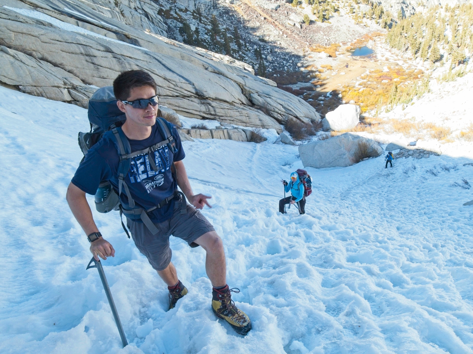
Once above the climb, we weave through a few boulders and willows over to set of gently sloping granite slabs. The sun sinks below the mountains and I pull on an extra layer to stay warm as we clomp up the stone ramps. We soon reach more willows and follow cairns and a faint use trail to the foot of Upper Boy Scout Lake.
The hike to the lake has taken longer than I anticipated. I originally budgeted 4 hours for 2.7-mile, 3000-foot trek from the trailhead, and we took about 5 hours. With the sun already below the horizon, we get busy setting up camp and collecting water from a small creek flowing out of Upper Boy Scout Lake. The 11,300-foot elevation affects us all differently. Josh has a headache, Kim is feeling nauseous, and I discover that my appetite is almost entirely gone when I open up my cheesy rice and beans. Our various maladies make for a somewhat somber evening and we go to bed early, hoping to feel better when our alarms go off at 3:30.


Summit Day
10 April, 2021 | 8.5 mi | +3200 / -7100 ft | View on Map
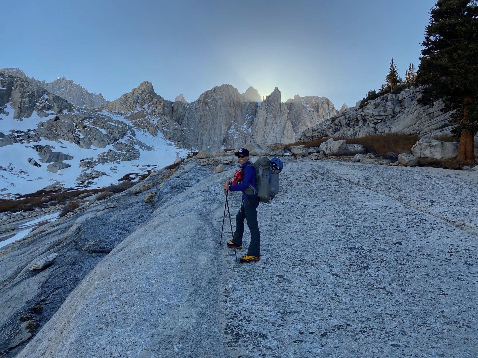
I’m not sure if I slept at all last night. I was warm and comfortable in my sleeping bag, but I tossed and turned; the night fell more like an extended period of eye-closing than sleeping. Josh and Kim didn’t sleep much either, but Josh and I are both feeling considerably better than we did last night. Unfortunately, Kim still feels sick and decides to stay at camp, get some more sleep, and hopefully feel better later in the day. On a lighter note, about a million stars are visible overhead, including the galactic core!
After eating a light breakfast and gathering our food, water, layers, and tools, Josh and I traipse off into the darkness. Just a few hundred feet from our campsite we reach a snow slope that leads up toward Mt. Whitney. We pull out our crampons and, after a few adjustments, begin crunching up the hill. Route-finding in the dark is never an easy endeavor, but there are plenty of boot tracks to follow and only one valley to hike up.
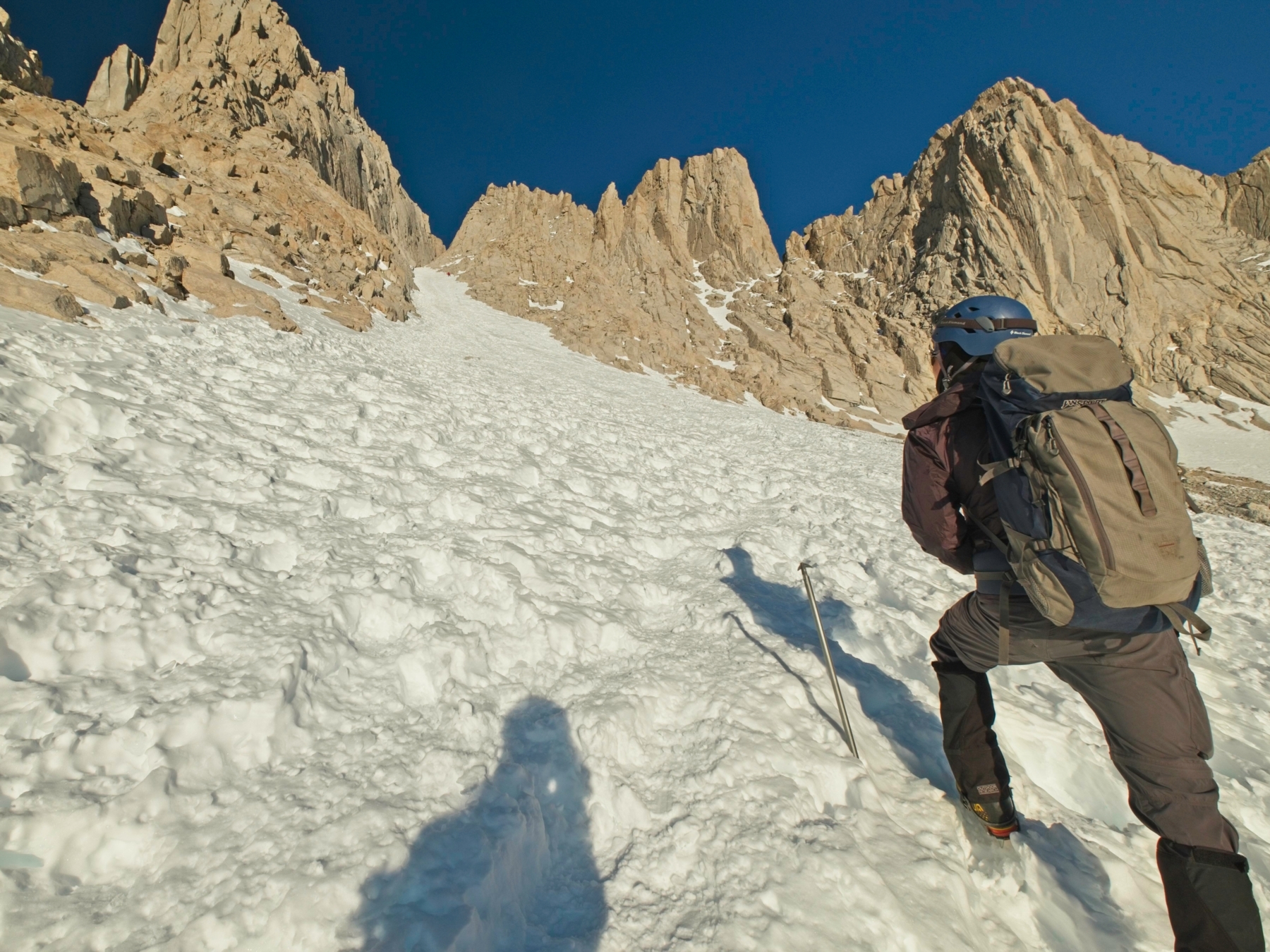
The snow slope soon gives way to a rocky traverse below some cliffs. Our crampons creak and scrape like nails on a chalkboard, but there is enough intermittent snow to keep them on. We traverse beneath the cliffs until we reach a steep, snow-filled chute that leads up to Iceberg Lake. In retrospect, we would have made better time by following a lower, snowier route below the cliffs, but this path worked out just fine.


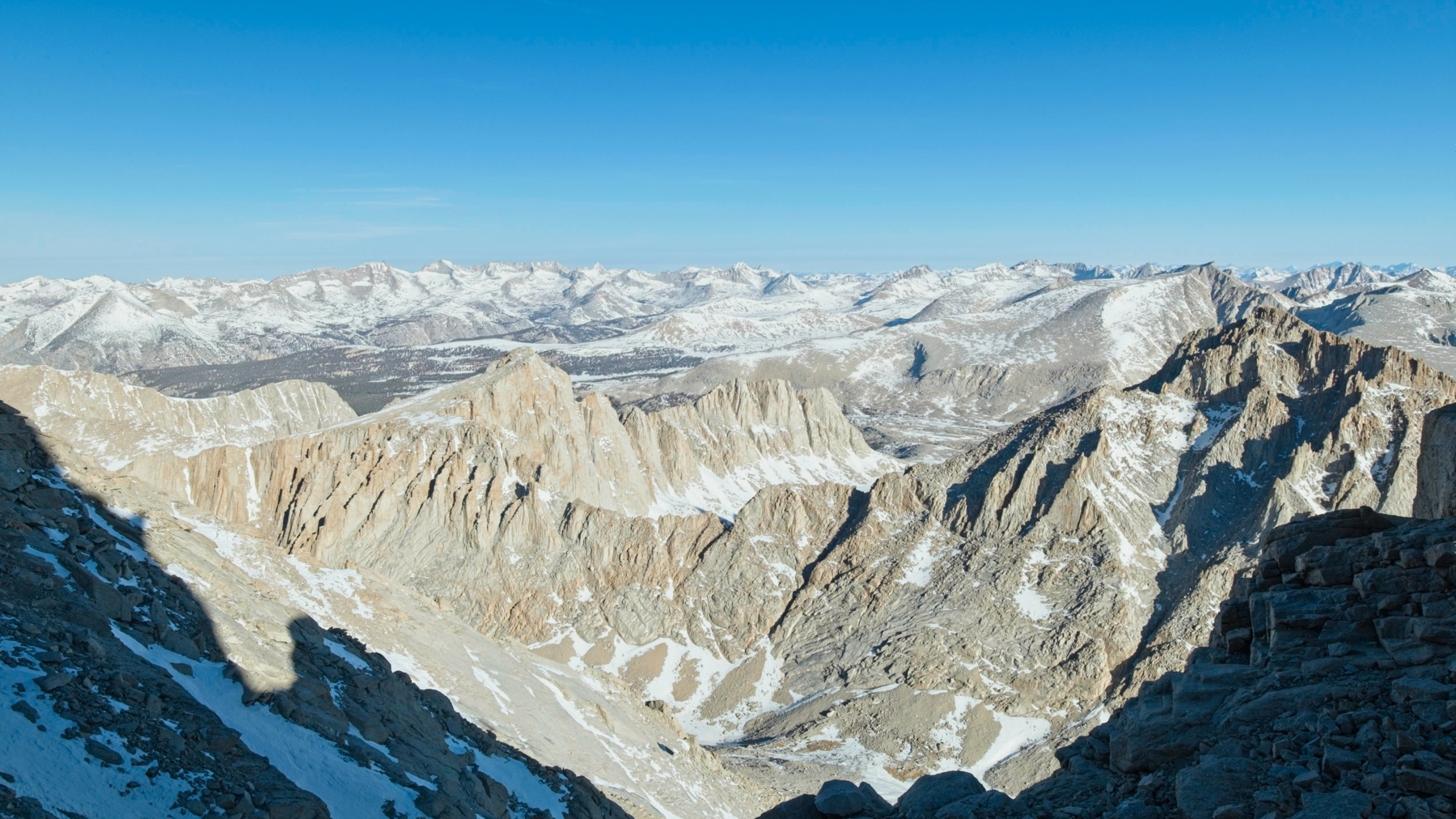
As we make our way up the steep, icy slope, the sun peaks above the horizon and casts a warm glow on Mt. Whitney. It’s an incredible sight, one you don’t get from the main trail, which is in an entirely different valley. Once we’ve reached the Iceberg Lake plateau, Josh and I both snap pictures of the beautiful light.


The final portion of the mountaineer’s route is clearly visible from Iceberg Lake. A snow-filled couloir, a.k.a., “the chute,” leads to a col (“the notch”) just below the summit. From there, it’s a short 400-foot scramble up another steep chute to the summit. Alternatively, you can traverse along the north-facing slope to reach the summit plateau. Our plan is to climb the steep chute, frequently called “the final 400”, on the way up and then take “the traverse” on the way back to avoid downclimbing in mixed snow and rock.
Although the total travel distance in the chute is a meager half-mile, you gain about 1500 feet of elevation! Josh and I climb steadily, taking many, many breaks to breath, drink water, and eat snacks along the way. I enjoy practicing the different crampon techniques I’ve learned, relying mostly on the “flat foot” technique (pied à plat) to avoid over-straining my calves. Partway up the chute we meet a group who have traveled all the way from Alabama for this climb! We’re also slowly gaining on several groups that are roped up, presumably traveling with a hired guide.


Josh and I reach the notch about 90 minutes after departing Iceberg Lake and take a few minutes to rest. It’s a tad crowded up here with about a dozen people that are all on guided trips lounging in the sun. A stiff breeze motivates me to pull out my puffy jacket while we wait for a guided group to begin climbing up the final 400-foot section.
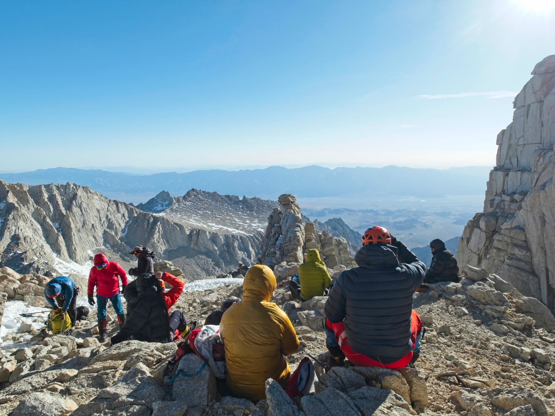
Once the guided group has left the notch, Josh and I scramble up into the final chute. Climbing the class 3 rock with mittens, mountaineering boots, and crampons feels precarious to me, but I follow Josh’s lead and soon make it to a more comfortable, albeit very steep, snow climb. We carefully climb past the guided group we’ve been following and then skirt past another group that is further up the slope. We could wait for them to iterate through their climb-belay-climb sequence, but I’m not keen on waiting in the cold and there is plenty of room to maneuver.
The top section of the final 400 is very steep, although I’m no good at guessing the actual angle. I switch to front-pointing with my crampons and use the ice axe pick (i.e., the blade) rather than the spike (the bottom of the shaft) to secure the axe in the slope. A few minutes later, Josh and I scramble up onto the Mt. Whitney summit plateau! There’s barely any snow to be found up here, nor are there any other people. We haven’t seen anybody descending the mountaineering route, so we may be the first people on the summit today!


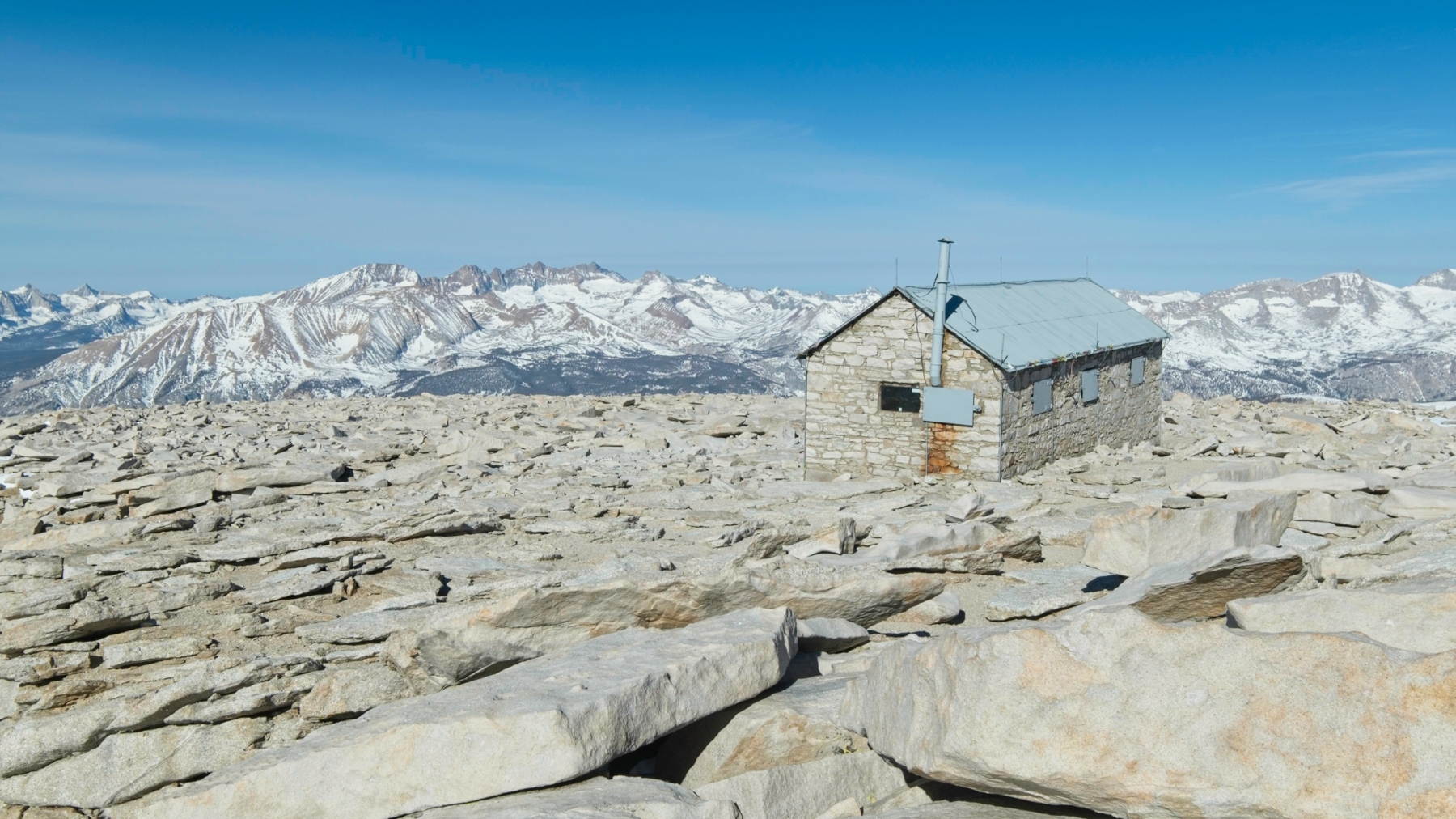

After taking a few photos with the summit sign and of the snow-capped Sierra Nevada range, we retreat to the shelter of the summit hut to eat a snack. The wind is very chilly up here, and the inside of the hut is at least calm, even if it is filled with snow. We don’t stay for long, however; Kim is waiting at camp and we have to hike all the way back to the car today. We follow the traverse on the way back, which is a longer walk but a much shallower grade. After reading numerous trip reports about how extreme the exposure is, I’m a bit underwhelmed. The slope is moderately steep, but it’s mostly talus and the snowy sections have well-established paths through them. It’s one of the more comfortable sections of the climb, in my opinion.


Descending down the chute takes far less time than the ascent, but feels much scarier to me. I mostly follow the boot path down, mixing a side step with front-pointing feet since the snow is too solid to plunge-step down. At least another dozen climbers on their way up the mountain pass by; many of them began this morning at Whitney Portal! They must be in incredible shape (and already acclimated to the altitude) to do this as a day hike. On the other hand, many of them seem completely exhausted, not a good sign with over half of the hike left to go.

We make quick work of the rest of the descent. Now that we can see the entire landscape and have some experience navigating it, we choose a more direct path back to Upper Boy Scout Lake, arriving a full hour before we planned to. We trade stories with Kim, who is feeling much better now, eat some lunch/snacks, and pack up our gear.


The hike out to the car also proceeds quickly, although not without its challenges. The snow softens in the afternoon, particularly around Lower Boy Scout Lake, and we post-hole many times as we descend. Down-climbing the Ebersbacher Ledges is also a bit of a challenge and those snow-covered slabs below the ledges prove just as slippery on the way down as they were on the way up. On the other hand, after all of the steep and uneven slopes, the main Mt. Whitney trail feels like a paved road and is a piece of cake.

As we walk back to the car, I reflect on the weekend. I’m proud of our planning and execution. We gathered trip reports, route descriptions, weather reports, etc., and made a solid plan. We stuck to our timeline and made what I think are smart decisions about our health and safety. In the future, I think I’ll include an overnight stay at the Whitney Portal before beginning this route to help with acclimatization; mild altitude sickness was the biggest discomfort/danger for us. I’m looking forward to climbing this route again!
Judy Eberhardt 22 April 2021
I am 82 years old and did this climb in 1945 with my father and my brother, we camped in the portals for 6 months that year. It was a wonderful time in my life. All the lakes in the paths trails have had their names changed. Other than that it was like going back in time. Thank you for bringing back memories
Andrew 28 April 2021 — Post Author
Wow, spending six months up there sounds like a wonderful experience!
Andre Colmenares 30 April 2022
So cool! And what a time to be in the portal. Do you ever cross paths with some influential figures around that time like Norman Clyde or anyone else? Would love to hear!
Michael 28 April 2021
My friend and I climbed the same day as you. Loved getting to see other photos of the same day as our climb. Excellent write-up!
Andrew 29 April 2021 — Post Author
Thanks!
Lucas Paolella 9 May 2021
Your photos make the phases of the climb clear to those never having done this route, unlike myself who’s been back at least 6 times. I know there other climbs in the Whitney Zone, like Langley, Williamson and Tyndall which I’ve done but there’s just something addicting, magnetic about this climb. Clicking on your individual images brings with it features seldom offered in reports, black frame and removable captions. Nice work. Nice climb.
Andrew 9 May 2021 — Post Author
I’m glad you enjoyed the images!
Tony 21 February 2022
Nice report! Could you add some photos of the last 400 please? I am wondering how the crampons worked out?
Andrew 23 February 2022 — Post Author
Thanks Tony! I don’t have any pictures of the final 400, unfortunately. I was too busy climbing to snap photos.
The crampons worked great – front pointing in the steep snow felt comfortable and stable. They were also very valuable in the main chute since much of the snow was icy.
Roger 21 April 2025
Hi! This article was very helpful! I am planning to climb in May. I have done the regular/main trail in early November. Do you recommend taking the Mountaineer’s route if the 99 switchbacks are fully covered in snow? Is the main trail still accessible/safe with proper gear? Thanks in advance!
Lucas Paolella 21 April 2025
That depends on which November you plan to go. Most Late season climbs or the North Fork trail are much easier when there’s less or no fresh snow to deal with. Particularly negotiating the Ebersbacher Ledges where climbers have lost their lives – even in the summer. The other portion would be beyond the Knotch. Not for the faint of heart.
That being said, it’s the only route I would consider. No question.
Andrew 21 April 2025 — Post Author
Hi Roger, I’m glad the article was helpful!
As Lucas points out, the mountaineer’s route includes more technical travel than the main trail, including the E Ledges. In particular, the chute and upper-400 sections of the climb are steep! That said, I believe the main “trail” also detours away from the 99 switchbacks in winter conditions and ascends directly up a nearby chute to the saddle.
So for either route you’re going to need to be well-practiced in crampon techniques and self-arrest. If you’re not, I’d suggest hiring a guide (I know Sierra Mountain Center guides the mountaineer’s route). People regularly die up there, so don’t underestimate it. And don’t let the possession of the correct gear be enough – you need to know how to use it as well!