Serendipity is a fun way to meet hiking buddies. Two weeks ago, I happened to meet a woman named Liz in the Whitney Portal parking lot. I was hiking up to Mount Russell; she and her friends were summiting Mount Whitney via the Mountaineer’s Route. We ran into each other again that evening and got to talking about future adventure plans. When I said I wanted to climb Mount Williamson and Tyndall but hadn’t been able to get a permit, they offered to add me to their group (of 13 people!). While joining a big group of strangers for a 3-day mountaineering trip was a bit daunting, I accepted their invitation and I’m sure glad I did! I had an incredible time and made many new friends over the weekend.
Mount Williamson is California’s second tallest mountain at 14,380 feet; Tyndall is a tad shorter at 14,025 feet. Reaching these peaks is no easy task. The approach is a 10-mile walk with nearly 6800 feet of vertical gain, and that’s before you even begin the class 2-3 climbing! Stronger hikers than I complete this trip as a day hike, but I highly recommend camping just above Shepherd Pass. Not only is it a lovely place, but you’ll acclimate to the 12,000-foot elevation overnight. I prefer to take a little more time and actually enjoy the trip rather than push through the misery of an insanely long day.
Trip Planning
Specs: 30.25 mi | +/- 15600 ft
Difficulty: Mostly class 1 & 2, with a little class 3 [learn more]
Location: Inyo National Forest and Sequoia National Park | Home of the Tubatulabal, Eastern Mono/Monache, and Western Shoshone peoples | View on Map
Route: This route is subdivided into several parts,
- Approach – Start at the Shepherd Pass Trailhead. You’ll need a vehicle with a fair bit of clearance to navigate over the deep dips and moderate-sized rocks. You can always park a bit further from the trailhead and hike about a mile extra. Follow the Shepherd Pass Trail to Shepherd Pass.
- Polychrome Peak – From Shepherd Pass, scramble up the west ridge of Polychrome Peak (class 2 with a few class 3 moves) to the summit plateau. For an easy descent, head down the sand-covered, class 1, southeast ridge.
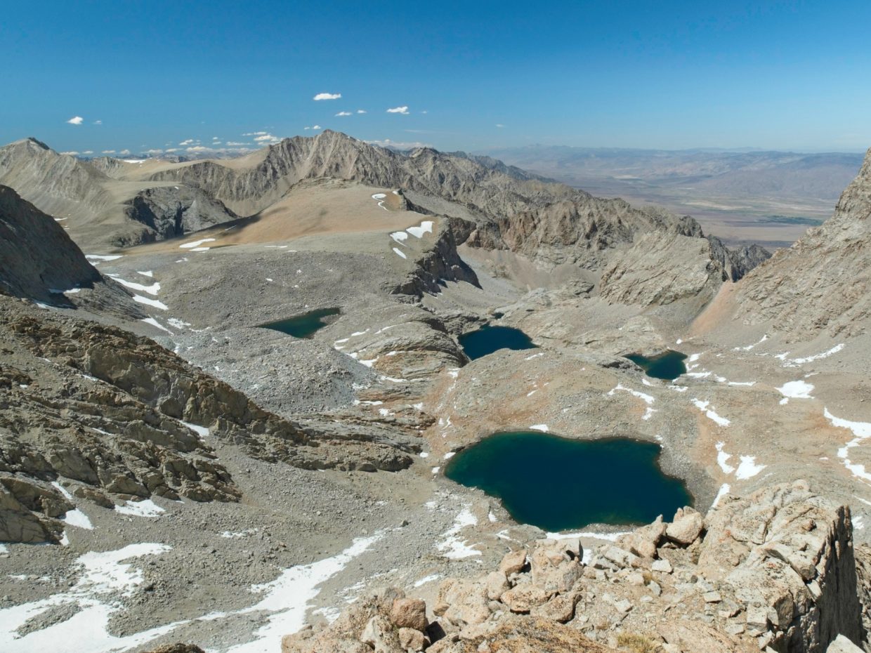
- Mount Williamson [West Face] – From Shepherd Pass, trek southeast to the Williamson Bowl. Cross this talus-filled area via the prominent ridge/moraine running through the center and make for the north bank of the southern-most lake. Scramble up to the “black stain,” a water-streaked face, and then continue up the obvious class 2 chute until it ends in a headwall. A class 3 chimney on climber’s right leads to an expansive plateau just below the summit, which you reach via one more class-2 scramble. For a more thorough description, see SummitPost.
- Mount Versteeg [North Slope] – From the southernmost lake in the Williamson Bowl, scramble up the class 2-3 north slope. The first 500 feet or so can be climbed on solid talus, but you’re forced onto loose crap higher up the slope. Persevere to the solid rock surrounding the summit!
- Mount Tyndall [North Rib] – From Shepherd Pass, head southwest to the foot of Mount Tyndall, making for the easternmost rib of talus on the otherwise slab-covered face. Scramble up this class 2-3 rib to the notch in the ridge above, then traverse east to the summit. For a more thorough description, see SummitPost.

Permits & Regulations: You need a wilderness permit for overnight trips in this area. If you follow the same route as described above, see the Inyo National Forest Wilderness Permit page on Recreation.gov. Bear-proof food containers are strongly recommended, but you can also use the counter-balance technique to hang your food. Otherwise, the usual wilderness regulations (Inyo | Seqouia) apply.
Resources: I recommend the Sequoia and Kings Canyon National Geographic map for trips in this area. The Tom Harrison Mount Whitney High Country map also covers the area. For trailhead information, visit the forest service page for Shepherd Pass.
Shepherd Pass and Polychrome Peak
11 June, 2021 | 11.7 mi | +7840 / -2180 ft | View on Map
I hop out of the car at the Shepherd Pass Trailhead and stretch while glancing around at the lot full of cars. Liz and Judy, the two hikers I met a few weeks ago, introduce me to the eleven other people in the group. Although it’s early (6 AM), everyone seems excited to be getting into the mountains for the weekend. We hit the trail soon thereafter to take advantage of the cool morning hours (the forecast is calling for 90+ degree temperatures in the valley this afternoon). At first, the trail remains fairly level, winding along Symmes Creek. The flat path soon gives way to gradual switchbacks that climb 2700 feet through an open pine forest to a sandy saddle. We rest at the saddle for a while and stare out at Mount Williamson, a commanding peak directly to the south and one of our climbing objectives for the weekend. Mount Tyndall, the other peak we’ll climb, isn’t visible yet. The trail descends several hundred feet from the saddle, only to reverse slope and begin climbing again. We’ve left the trees behind and sun beats down, but time passes quickly as I chat with various people and get to know them a little.


After a leisurely lunch break in the shady woods surrounding “Anvil Camp,” we continue up the trail into a desolate landscape of talus and scree. Shepherd Pass looms in front of us, a seemingly vertical wall. But as I get closer, I spot the switchbacks leading upward and the slope appears more manageable. It’s a steep climb, but I’m feeling strong and make quick work of them. This is the third weekend in a row I’ve hiked at high altitude, and it’s paying off!


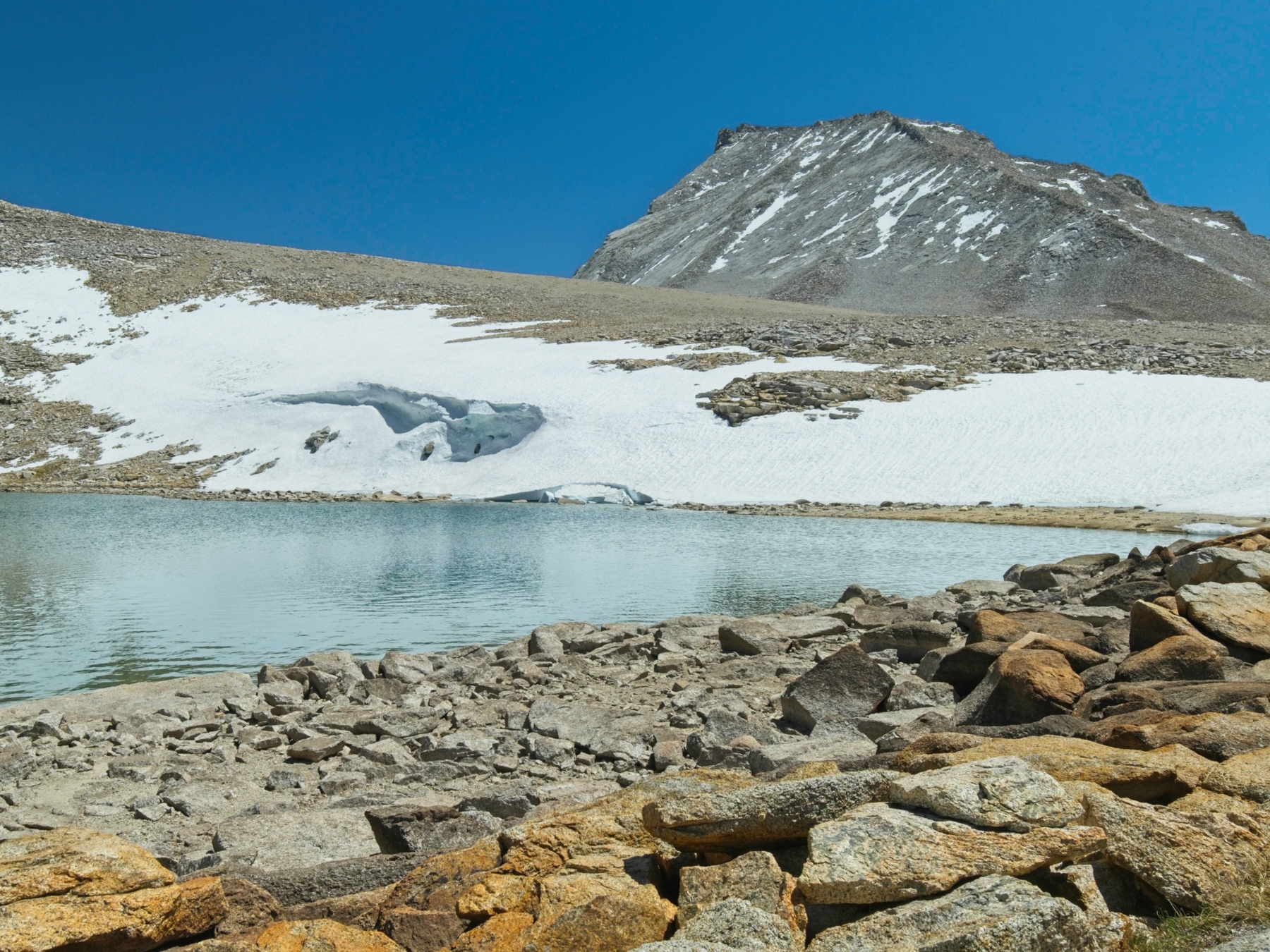
Just beyond the pass lies a pristine, unnamed lake. Polychrome Peak towers above the water, thus I propose “Polychrome Lake.” I’m the first person in the group to arrive, so I explore the lake shore and find a nice campsite with a view of the lake and some shelter from the wind.
The others arrive just a few minutes later. Sully, Bartek, Craig, and I decide to go climb Polychrome Peak. Its summit rises about 1000 feet above the lake, but we have plenty of time to kill this afternoon and can afford to take our time scrambling up. I enjoy the climb up the west ridge, which consists mostly of class 2 terrain with a few class 3 spots sprinkled in. At the summit we find a small, sandy plateau and several rocky towers. After a quick inspection, we scramble up the tallest one and take a few photos. For the hike back to camp, we follow the more gradual southwest ridge, plunge stepping through the soft sand for a while and then weaving between and over the scattered talus.


For the rest of the evening, we relax at camp. I sit and chat with everyone in what has become the communal cooking area. The warm afternoon sun feels nice up here at 12,000 feet. Once the sun sinks below the horizon, the temperature become downright chilly and people drift off to their tents for the night. We’ll be heading out tomorrow bright and early to climb Mount Williamson!

Mount Williamson and Mount Verstseeg
12 June, 2021 | 8.4 mi | +/- 4600 ft | View on Map


I set my alarm a little earlier than necessary this morning so that I can take some pictures of the mountains during the sunrise. I’m glad I did, too, because the light on Mount Tyndall is gorgeous! After enjoying a warm oatmeal breakfast, I gather my hiking gear and join the rest of the group on an easy stroll over to the Williamson Bowl. Mount Williamson casts long shadows over most of the valley as we pick our way down the talus slope. Our route follows the ridge across the center of the bowl over to the highest lake that lies just below Mount Williamson. A quick scramble up another talus slope brings us to the foot of the climb. We all don helmets – with a group as large as ours, there’s a significant risk that someone will dislodge a rock and send it tumbling down on climbers below.


 beginning the scramble")

Once everyone has arrived and is accounted for, we begin the climb. It’s easy going at first, though steep, on solid talus. I make for the “black stain” landmark, a small cliff band darkened by running water. I enjoy the class 3 climbing up the vertical rock and emerge above it with Bartek and Sully. From here, the route is clear: we continue scrambling up a wide chute that leads nearly all the way to the summit ridge. I try to stick to the sides of the chute on solid rock and avoid the loose jumble of talus and scree in the center; the last thing I want to do is to send a rock hurtling down toward the others.
The climb up the chute is long — nearly 2000 vertical feet — but passes pretty quickly as I chat with Bartek and Sully. Our next challenge is a class 3 chimney leads from the top of the chute to the summit plateau. From the bottom, it looks like a pretty straightforward climb and I’m excited to give it a try. The first ten or fifteen feet are uncomplicated, followed by a narrow pinch that I navigate with hands and feet braced against opposite faces. Above the narrow spot, the climbing gets easier again and I soon pop out onto the wide, sandy summit plateau.


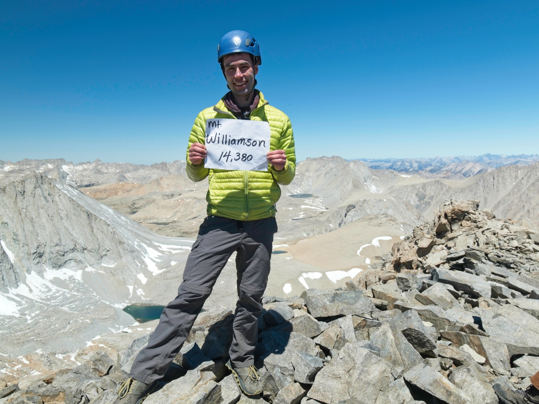
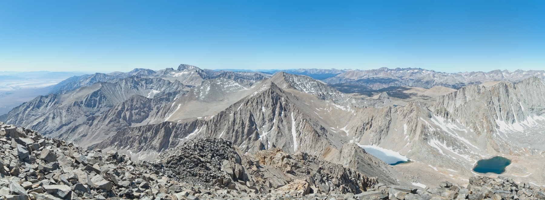
One final scramble up some more talus delivers us to the summit of Mount Williamson, California’s second tallest mountain! We spend a while relaxing up there, waiting for everyone to arrive and enjoying the 360-degree views of the Sierra Nevada mountains and Owens Valley.


At about noon, people begin heading back down the mountain. I’m not particularly excited about the long descent or downclimbing the chimney, but both prove easier than expected. By the time I reach the lake where we began our climb this morning, I’m feeling famished and happily chow down on peanut butter, flat bread, and dried applies while chatting with Bartek, John, Craig, Cherie, and Sully. Craig is going to climb yet another mountain today, Mount Versteeg, which towers above the opposite side of the lake. After eating, reapplying sunscreen, and resting for a bit, I decide to join him. My legs are feeling great and… why not climb another mountain?
So Craig and I set off around the lake and begin scrambling up a nice, solid granite rib. Craig has climbed mountains all over the world and I enjoy hearing about the adventures he’s been on. We eventually run out of solid granite to climb and struggle up an incredibly loose scree slope for a few hundred feet to the summit block. A little more scrambling (and wheezing on my part… 13,000 feet is still not easy) and we stand atop the airy summit! I snap a few photos of the Wright Creek Basin that is now visible on the opposite side of the mountain and reminisce about hiking the John Muir Trail when I camped at one of the lakes far below. Our view of the Williamson Bowl is equally as impressive. Looking across the valley at Mount Williamson, we can easily see the chute we climbed this morning but it appears vertical from this vantage point! We also try to spot our fellow climbers below but are unsuccessful; they’re just too far away. After signing the summit register, we scramble back down the mountain, plunge-stepping through a sandy slope to the side (skier’s left) of the rib we ascended.


We rejoin the group during the hike back across the Williamson Bowl. Scrambling up the talus slope on the western edge of the bowl is more work than I’d like after a long day of climbing, but it doesn’t take too long and I’m soon free of the talus. I stroll down the sandy slope, chatting with my new friends, and enjoy another leisurely evening at camp.


Mount Tyndall and A Long Descent
13 June, 2021 | 13.15 mi | +3200 / -8900 ft | View on Map
We get up before dawn this morning for our final climb of the weekend: Mount Tyndall. Thankfully, the approach to Tyndall is quite short, just a quick jaunt up the hill from our campsite. I’m downright cold this morning so despite the mountaineering motto, “Be bold; start cold!” I hike the entire approach in my jacket. By the time we reach the north face of Mount Tyndall, however, I’m feeling much warmer and shed layers before beginning the climb.


Today’s climb follows a rib of talus and slabs all the way to the summit ridge. It appears a bit imposing, but, like most mountain climbs, is more straightforward once you start putting one foot in front of the other. I find this route easier than the loose chute scramble we did yesterday; at least the talus and slabs are solid here! My favorite part of the ascent is the last fifty feet or so. A snowfield covers the upper portion of the rib and, rather than try to cross the ice, I veer to the side and climb up a network of slabs and cracks until I’m above the snow and can contour to the notch that leads to the summit ridge.


")
We all gather at the notch and take a short snack break before scrambling up onto the ridge. Like Mount Williamson, the path to the summit is a simple talus slope and we quickly reach the peak. The highest point is a boulder right on the edge of an enormous cliff that drops straight down to the Williamson Bowl. A few of us (very carefully) climb up and pose for a photo before sliding back to solid ground. We rest for a few minutes, munch on some snacks, sign the summit register, and then begin the climb back down.


 climbed to the absolute summit of Mount Tyndall; an airy 2000-foot drop lies just behind this boulder; photo credit: Sully")


Just like yesterday, the descent is easier than I anticipated and I soon reach the easier terrain at the foot of the mountain. I pause a few times while wandering back to camp to photograph the Great Western Divide, that awesome line of peaks that dominates the western skyline.

Back at camp, I pack up my gear and head down the Shepherd Pass Trail with Craig, Cherie, Judy, John, John, Bartek, Michael, and Sully. We spread out during the 10+ mile walk back to the trailhead and I enjoy some quiet time. A consistent breeze keeps me cool as I trek down the trail under the blazing afternoon sun. I’m pleasantly surprised to be enjoying the hike, even the 600-foot climb that breaks up the otherwise downhill journey. I don’t enjoy the switchbacks though; they stretch on for what feels like hours.


When I finally emerge from the mountains, I’m happy to find several people still hanging out in the parking lot, drinking cold beers and laughing. I join them and relax in the shade of the lone pine tree. This has been a fantastic weekend, and I’m happy to have met a group of amazing people!
Steve 28 June 2021
Thanks for a great write-up and gorgeous pictures, as always, Andrew. Those are some rugged mountains!
John Kang 1 July 2021
Very nice report, Andrew. I was very happy to participate in the fun.
Roo 20 May 2024
Great pictures and report! Helpful info too. 🤙🏽
Mark Hannibal 29 August 2024
I will be doing this same itinerary with a friend of more than 40 years, in September. Thanks for the write up. I am very excited!