I was at the gym on Thursday when Maddie asked me if I wanted to do a ski-tour up Birch Mountain (13,602 ft) on Saturday. It’s a huge climb – 7200 feet of gain over about five miles – but I haven’t been touring yet this season and it sounded like a fun challenge, so I said sure! We didn’t end up making it all the way to the summit, but the ski conditions were fantastic and I really enjoyed the day.
Trip Planning
Specs: 9.0 mi | +/- 5000 ft
Difficulty: Class 1 [learn more]. Slope angles between 25 and 35 degrees, pretty wide-open terrain
Location: Inyo National Forest, California | Home of Western Shoshone, Eastern Mono/Monache and Northern Paiute peoples | View on Map
Route: We began near McMurry Meadows and followed the ridge north of Fuller Creek until the snow coverage was sufficient to start skinning (around 8300 ft); we followed the north fork of the creek from there and then skinned directly up the southeast face to the foot of the chutes. We skied down from there, following the north fork of Fuller Creek down to 7000 feet where the snow ended. We then hiked about a mile back to the road around McMurry Meadows.
Permits & Regulations: No permits are required for day trips in this area, and there are no parking restrictions along the McMurry Meadows Road. Wilderness regulations do apply and, as always, make sure you leave no trace!
Resources: Greenberg and Mingori’s Backcountry Skiing California’s Eastern Sierra includes some information about this route, but there are not many other resources available. The Eastern Sierra Avalanche Center occasionally forecasts as far south as Big Pine but you’ll probably have to rely on your own assessment of the avalanche risk.
Committing to the Climb
Saturday, 16 Mar, 2023 | 9.0 mi | +/- 5000 ft | View on Map
Maddie and I leave LA mid-afternoon on Friday. It’s a stormy day – the radar shows rainstorms scattered from LA all the way up to Big Pine – and we drive through intermittent showers for several hours. The gloomy, wet weather is not at all inspiring conditions before a ski tour. We’re very uncertain about the snow conditions on Birch Mountain as well. A friend of Maddie’s sent a photo from a week ago that shows good coverage up there, but a lot can change in a week (it’s been both sunny and windy) and we don’t have any updated information. The low-hanging storm clouds obscure the peak tonight so we don’t get a look ourselves before dark.
The plan is to begin at McMurry Meadows and climb directly up the southeast face of Birch Mountain to the summit ridge and then onward to the summit. The net elevation gain is about 7200 feet over five miles, so it’s a very steep climb and we figure we’ll need ten or eleven hours to reach the summit and then at least three hours to descend. Working backward from the time we want to be off the mountain, we plan to start the trek at 2 AM.
We arrive at McMurry Meadows, a grassy plain below Birch Mountain, at about 7 PM. It’s soon completely dark and we get four or five hours of sleep before the alarm goes off at 1 AM. It’s snowing, so the mountain is still obscured from view. Neither Maddie or I make any effort to get up for several minutes. We’re both struggling to muster the motivation to hike up a mountain in the dark… we could sleep for four more hours and then go ski at Mammoth; just about anything else would be easier than climbing Birch Mountain.
After minutes of internal struggle, we get up and pack our things. Conditions may be terrible or they may be amazing and there’s only one way to find out. We’re on our way by 01:50, following a 4WD road winding up to the top of a ridge that leads to the higher reaches of the mountain. It’s a soggy walk with water running down the tire tracks and patches of fresh snow all over; we’re both careful to keep our feet dry.
Maddie and I run out of road by 02:20 and begin bushwhacking through sagebrush on the ridgetop. It’s not pleasant, particularly with skis strapped to our packs, but we don’t have any other obvious options. It’s a hike on faith so far – we have no assurances that there’s even enough snow to ski higher on the mountain. Or, if there is enough snow, it may be solid ice, or windswept crusts, or some other unpleasant variation. On the bright side, the star have come out so there’s hope for sunshine in a few hours!
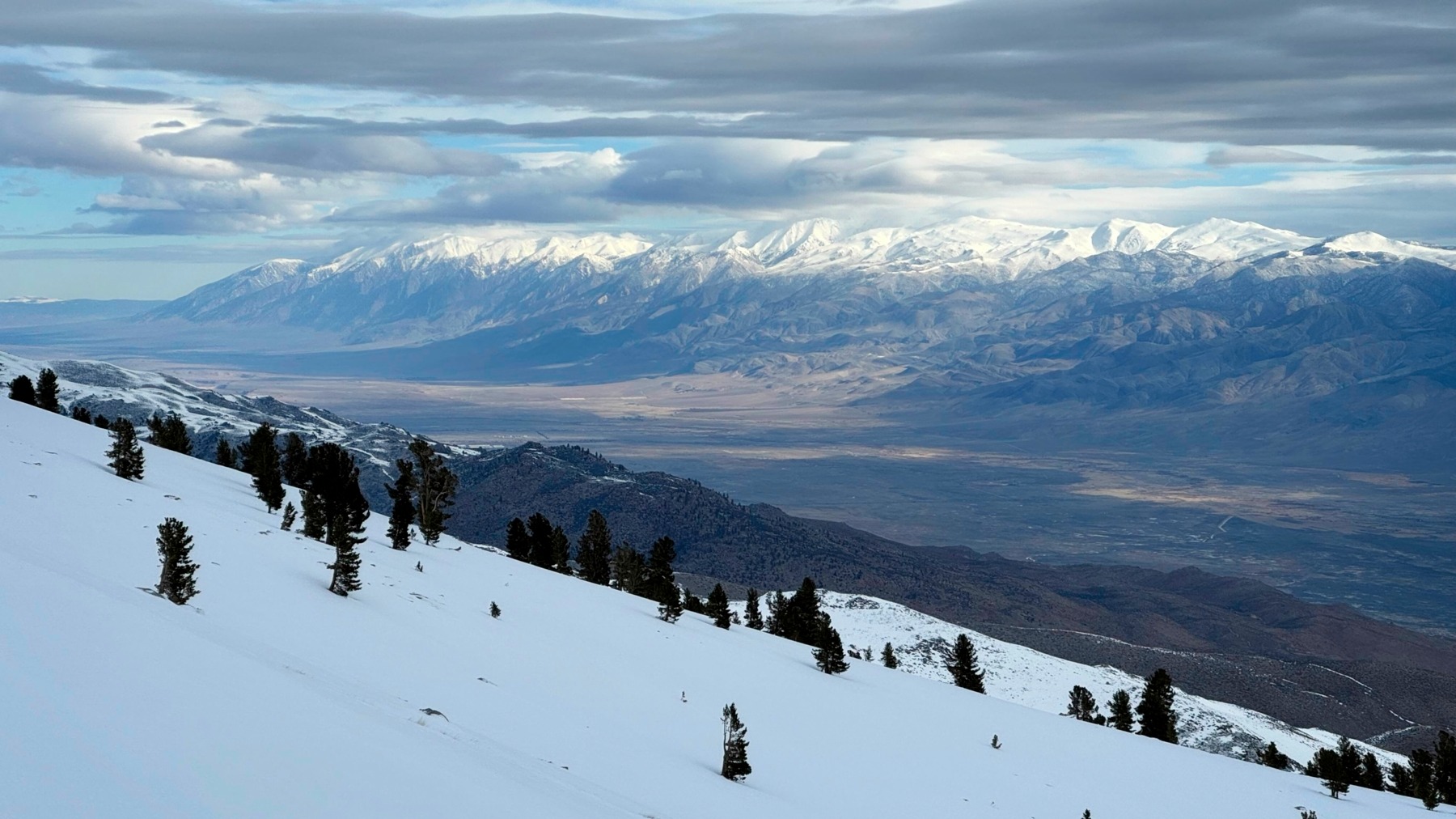
By 04:00 we’ve reached about 8200 feet and can see the soft glow of snowfields just below the ridge, so we hike down and begin walking on the snow. It’s much easier than the sagebrush and my optimism for the day increases as we trek higher into more and more snow. We soon transition to skis and skins and suddenly I’m having fun! By the time we reach 9000 feet at 05:00 we’re swishing through a few inches of beautiful, dry powder that must have fallen yesterday and last night.


We quickly gain altitude as daylight slowly brightens the sky. We’re at 10,000 feet by 06:00 and 11,000 feet just after 07:00. The powder is getting deeper, the air thinner, and the slope steeper as we climb, and we’re both struggling with the effort. I’m having trouble keeping my edge on the snow; the dry powder sits on top of a firm sheet of wind affected snow and the powder is sloughing right off. I pause to put on ski crampons (Maddie has had them on from the start) and then continue up the track.


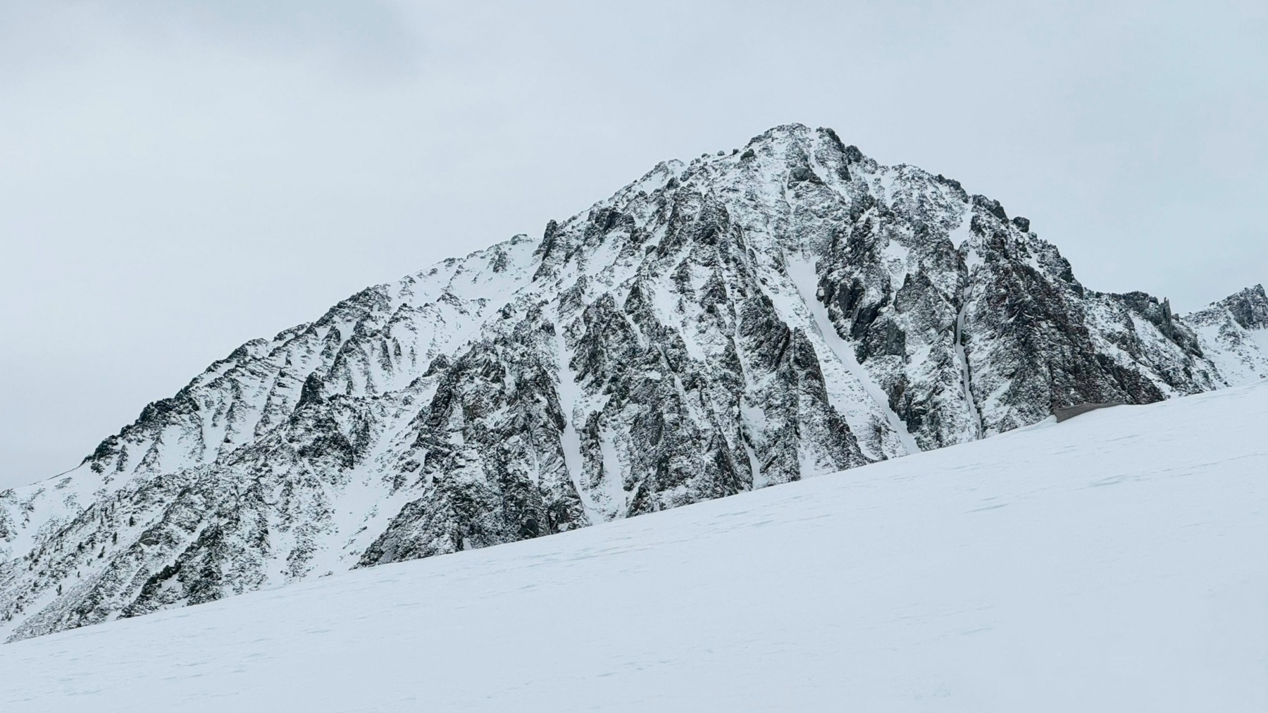
We take turns breaking trail and scope out the chutes above as we draw close to their base. A clear avalanche crown stretches across the top of the rightmost chute and the soft outlines of powder-covered debris dot the runout below. Although we haven’t seen any signs of instability, it’s a sharp reminder that these slopes have the potential to slide.
By 8:00 we’re both ready for a break and pick an avalanche-safe spot by a little tree a hundred feet above us. Gaining that hundred feet takes a full 15 – 20 minutes though; the slope has become too steep to skin and we switch to boots. I struggle to kick steps into snow that alternates between hip-deep powder and barely-buried rocks.


At the little tree (roughly 11,400 ft), Maddie and I stomp out a spot for our bags and take a break while discussing what to do next. We’re both interested in climbing up to the summit, but conditions are pretty brutal in boots; we have at least 1000 feet to hike up before the possibility of swapping back to skis on the wide, shallow summit slope. While I’m sure we could make it up there, all that extra effort could make the descent a very exhausting affair. Also, the snow below is is so good and we’re excited to ski it! Although the cloudy skies, light breeze, and cold air haven’t degraded the snow quality yet, that could change at any time.
So we make the call to abandon the summit and instead enjoy some sweet, sweet powder. Before starting down, we snack, admire the amazing views of Owen’s Valley, and Maddie shares a thermos of hot chamomile tea that really hits the spot. Then we peel of the skins, pack up our bags, and ski out onto the mountain at about 08:50. Maddie heads out first while I record a video – it’s rare to get this kind of powder in the Sierra and we want to remember it! I follow after her while she records and we swap being the skier and videographer a few times.


")

The skiing is excellent! Other than some rogue bumps from buried avalanche debris, we enjoy wonderfully smooth turns down thousands of feet of untouched (besides our own skin track) snow. Staying in the soft snow does require a little route finding – there are patches of hard crust on the windward sides of the slopes – but the powder is plentiful on large swaths of the mountain.
Once we reach 9000 feet, the snow begins to thin out and the powder mostly disappears. We keep on skiing, following a ribbon of snow on the north fork of Fuller Creek. The crusty, wind-swept snow makes for a very bumpy ride but it’s still more fun than walking! Neither of us are keen to hike back through all that sagebrush.


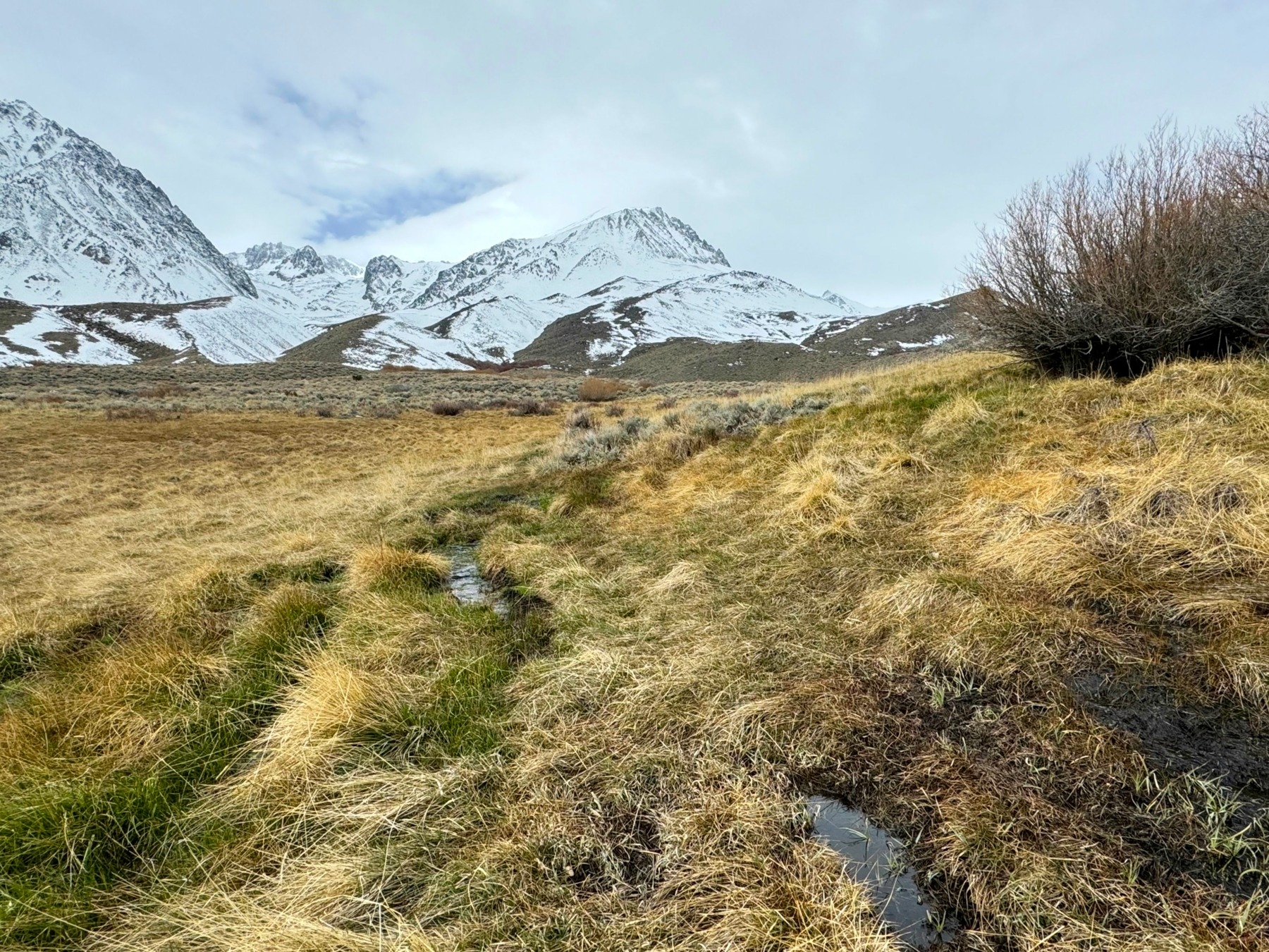
We manage to make it all the way down to 7000 feet on the snowy creek, arriving a little after 10:00. Here, the snow flows into a thick grove of trees that we cannot ski through. What a fun ski descent, all the way from 11,400 feet down to 7k! We transition back to shoes and stuff now-unneeded layers back into our bags. All that remains is a walk through some sagebrush and grass to return to the car.


As with earlier in the morning, the sagebrush bushwhacking is tedious. We manage to find our way to more open terrain pretty quickly and then enjoy a much easier stroll through McMurry Meadows, exalting the wonderful skiing the whole time. We find the 4WD road again, which is still soggy with a little brook running down it, but the snow has completely melted. And then we’re back at the car, just 9 hours and 20 minutes after starting out. Maddie and I pack our gear into the trunk and then drive off in search of a hot breakfast.