Maddie and I did not originally plan to tour up to Kid Mountain. Our goal was to ski The Thumb, a prominent 13,000-foot peak next to Birch Mountain at the southeastern edge of the Palisades. We changed course mid-tour when we reached a vantage point that revealed pretty thin snow coverage in the canyon below The Thumb. Luckily, Kid Mountain had plenty of ski-able slopes just around the corner, so we still summited a mountain and enjoyed many thousands of feet of skiing!
Trip Planning
Specs: 12.9 mi | +/- 6200 ft
Difficulty: Class 1 [ratings]
Location: Inyo National Forest, California | Home of Western Shoshone, Eastern Mono/Monache and Northern Paiute peoples | View on Map
Route: (This is not the only or the most direct route to Kid Mtn, but it is a route.) Begin at the Birch Lake Trailhead (high clearance required) and hike up the faint road through a marshy meadow. The trail becomes more defined where it turns north and climbs up a small gully. We transitioned to skins about 2.4 miles up the trail at 8200 feet and skinned up the drainage, roughly following the summer trail. At a plateau with a great view of The Thumb, we turned right (north) and traversed across the east face of Peak 12030 until we could skin up to the saddle south of Kid Mountain. Hiking to the summit from the saddle is a quick trip!
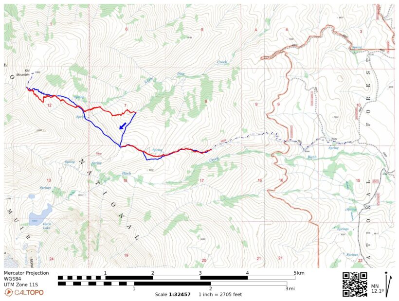
Rather than completely retrace our skin track and duplicate the long traverse, we skied down to about 9000 feet and then skinned up a gully back to the plateau. From there we skied down the same line as our skin track. Reverse the hike to return to the trailhead.
Permits & Regulations: Like most of the Eastern Sierra, permits are required for overnight trips but not for day hikes. There are no amenities (restrooms, water) at the trailhead. As always, make sure you leave no trace!
Resources: Visit the Inyo National Forest page for information about the trailhead, restrictions, and regulations.
A Diverted Ski Tour
29 Mar 2025 | 12.9 mi | +/- 6200 ft | View on Map
Maddie and I drove up to the Birch Lake trailhead after work on Friday and, after an invigorating drive on the 4WD access road, camped there. The forecast for today (Saturday) called for frigid temperatures of -15 F at the top of The Thumb with the freezing altitude hovering around 8000 feet. The forecast also predicted moderate winds. So, rather than getting a very early alpine start and struggling up ice in the dark, we set our alarms for a relatively luxurious 4:30 AM.
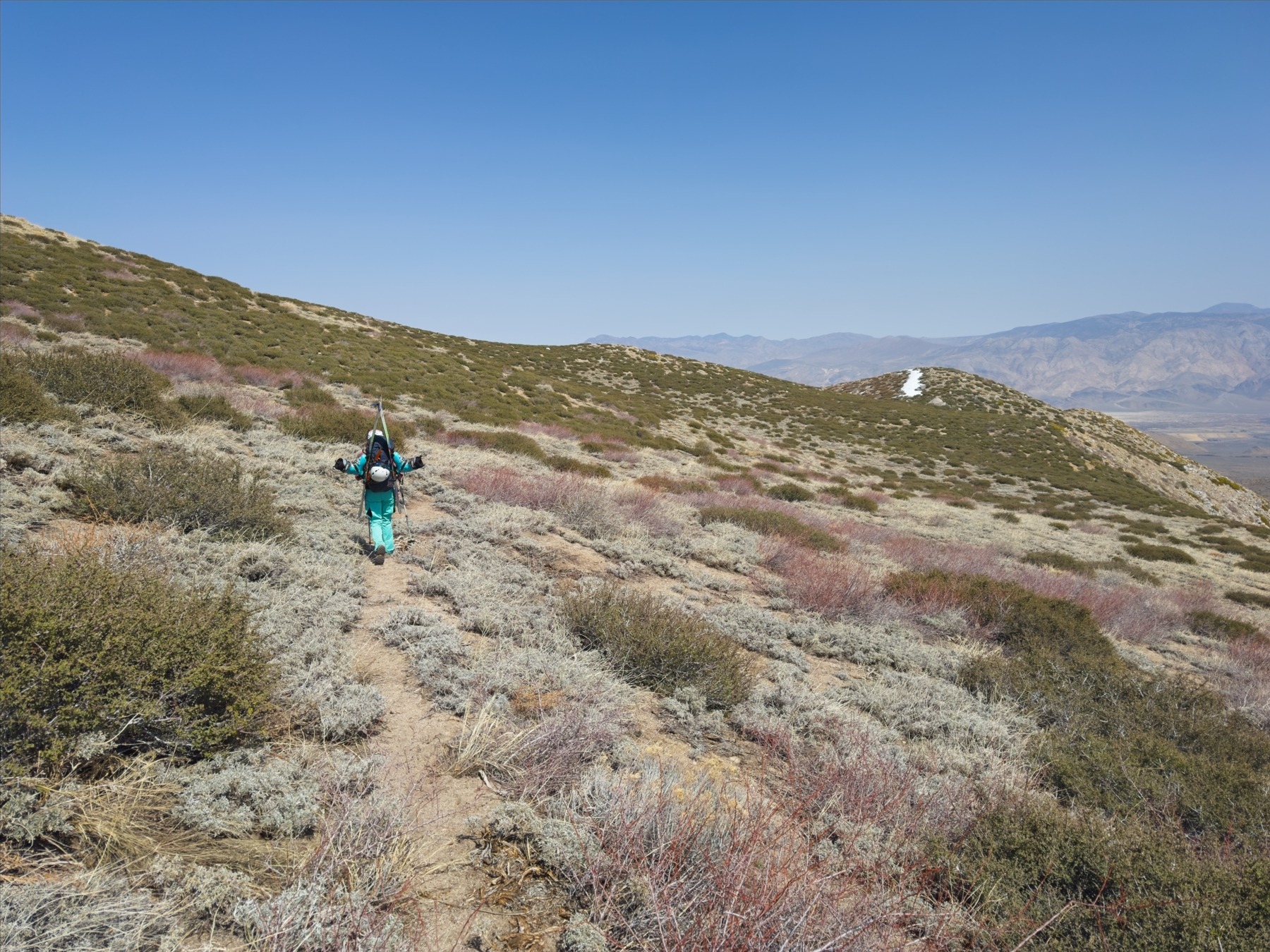
We’re on the trail, which starts out as an extension of the 4WD road, by 5:30 AM. We’re hiking in approach shoes for now and carrying our skis and boots to where the snow is. We weren’t able to get a good look last night since it was dark when we arrived and there’s a new moon right now, but satellite imagery from 10 days ago put the snow line at least a mile up the trail. It’s been hot and sunny since then, so we’ll certainly have further than a mile to walk before we can transition to skis.
We navigate marshy grass for a little while, careful to keep our shoes and socks dry. Soon we’re on higher, drier ground and we’re able to walk more quickly and confidently up the trail. The path soon turns steep, winding up the bottom of a gully for a while and then switching back across a hillside. We walk across a few small snowfields as the sun rises and then enjoy an easy stroll to a small creek and what looks like consistent snow cover!


Maddie and I leave our approach shoes beside the creek and skin up the drainage, weaving between budding willows and the occasional protruding rock. The snow is frozen solid, “bulletproof,” as skiers say. After a few frustrating slides, I pop on ski crampons to grip the ice better. We skin up about 1600 feet to a plateau at 9900 feet that offers a great view of The Thumb and the canyon below it.
My heart sinks when I see how rugged the terrain is and how much exposed rock there is between us and our goal. To reach the base of The Thumb we’ll have to traverse across many icy slopes, cross lots of rock bands, and likely transition between skiing, skinning, and booting a bunch of times. We’ll have to repeat that entire saga during the descent as well. (Upon re-reading the guidebook, you’re better off approaching from the Birch Creek Canyon, not the summer trail.)


For better or worse, Maddie has the exact same reaction as me. We hem and haw for a minute or two and then decide we’ll divert over to Kid Mountain where we can see lots of long, wide, uninterrupted snow bands to ski down. To reach those slopes, we first have to traverse across the east face of Peak 12030, which looks doable; at least there aren’t rock bands in the way.


Traversing turns out to be incredibly tedious. The snow remains bulletproof and my legs are constantly tensed to maintain an edge and avoid slipping. The ski crampons help a lot, but I don’t enjoy the cross-hill travel at all. It takes us about an hour and twenty minutes to reach the Little Pine Creek drainage. Maddie and I take a long break on a flat, rocky island to eat snacks and lounge in the sun a bit. We have no interest in skiing down snow this icy, so we’re happy to kill a little time and give the solar radiation time to soften things up.
After a 30 minute break, we skin up the final slope to the saddle that is just south of Kid Mountain. I really struggle with the altitude, huffing and puffing my way up, but Maddie seems to have no problem and beats me to the 11,700-foot ridge by several minutes. On the bright side, the snow is beginning to soften up a bit and I’m getting excited for the descent!
We take a brief hike up to the summit in our boots (very patchy snow on the ridge and summit), signing the register while we’re there. Kid Mountain isn’t on any peak lists that I know of so it doesn’t seem to get many visitors, but the view of the Palisades is stellar! We pick out mountains we’ve visited: Middle Palisade, Norman Clyde, North Palisade, Mount Sill, Temple Crag… this part of the range is great for climbing.


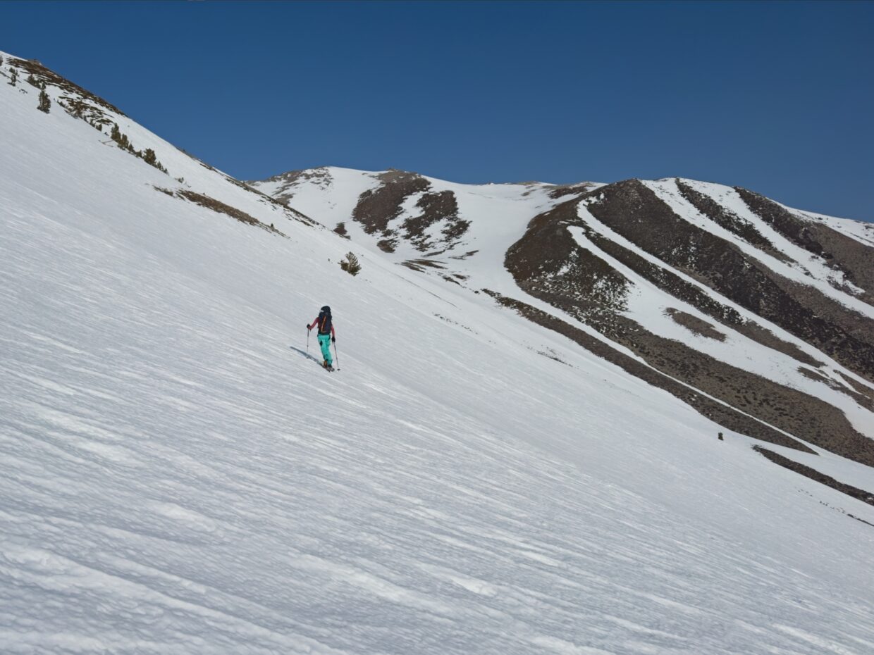
With the Kid Mountain summit in the bag and full noon sun on the east-facing slopes below us, the only thing left to do is ski down. Maddie and I quickly transition to skiing and start down the east face. It’s… not great. There are a few patches of soft snow, but it’s mostly edge-able ice sheets and crunchy sastrugi. Luckily, after descending about 1200 feet we find some soft snow and enjoy 1500 feet of really fun turns in the alpine. Of course, all these extra turns put us in the wrong drainage a full thousand feet below our skin track, but it’s completely worth it.
After a little “adventure skiing” down a thin tongue of snow to reach the correct gully, we transition back to skins and begin the climb back to the plateau. Although it only takes us 35 minutes, the 1000-foot ascent is an absolute slog. It’s incredibly hot under the midday sun, there’s little to no breeze in the gully, and my legs are very tired. But we make it up to the plateau, transition back to skiing, and then enjoy another 1800-foot descent on soft snow. It’s starting to get pretty mushy now, but I still have a blast!


Back at the bottom of the snow, Maddie and I reunite with our approach shoes and pack our skis away. Then it’s an easy but tired 2.4-mile walk back to the car. With the benefit of daylight, we find a slightly easier route through the wet meadow this time. We reach the car right at 3 PM, and, after a bit of stretching, bounce back down the road toward town and food.