When a winter storm dumped several feet of fresh snow in the mountains above LA, Brian and I wasted no time driving up there to do some skiing. Since Brian is new to backcountry skiing, we opted for the low-angle but still awesome Alto Diablo “North Trees” line in the San Gorgonio Wilderness.
Trip Planning
Specs: 15 Mar 2025 | 6.8 mi | +/- 2800 ft
Difficulty: Class 1 [ratings]
Location: San Bernardino National Forest, California | Home of the Serrano and Cahuilla peoples | View on Map
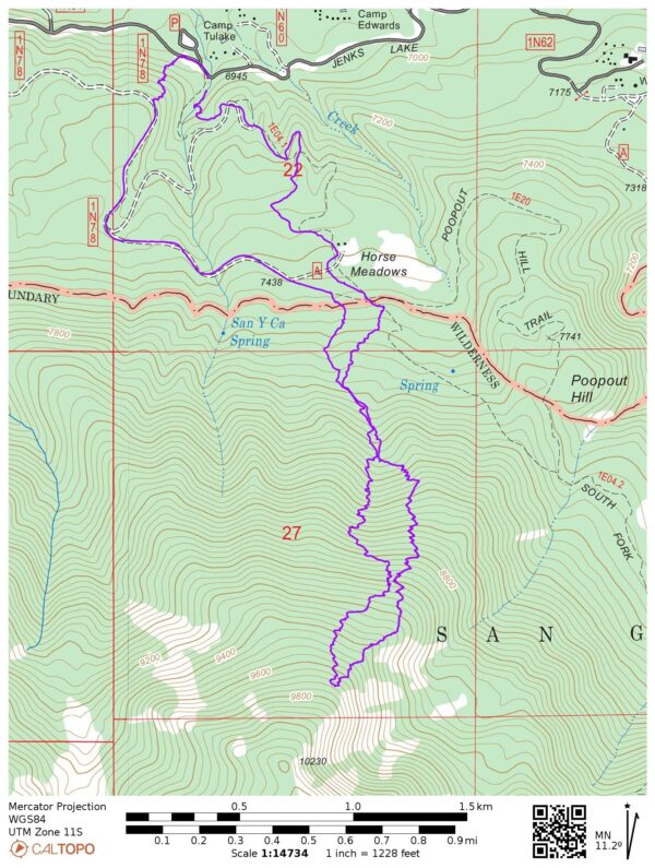
Route: There are two approaches to Alto Diablo. The most common is to follow the South Fork Trail up to Horse Meadows and then head uphill into the mountains. An alternative is to skin up forest road 1N78 from its intersection with Jenks Lake Road. The former is shorter but less likely to be ski-able on the way down, while the latter is longer but more likely to be ski-able. Pick your poison.
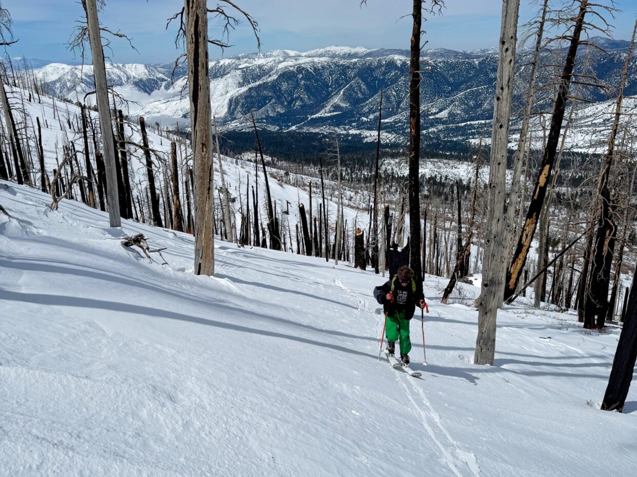
From Horse Meadows, skin up the north-facing slopes. From the few times I’ve been there, it seems like many skiers skin up the northeast ridge that ends near Poopout Hill, but there’s not really a compelling reason to go that way besides an established skin track. For our tour, Brian and I took a more direct line so that we could assess the snow stability on the slopes we intended to ski.
Permits & Regulations: Permits are required for both overnight trips and day hikes in the San Gorgonio Wilderness; visit the San Gorgonio Wilderness Association to reserve one. Additionally, you’ll need a pass (Adventure Pass or Interagency Pass) to park at the trailhead. As always, practice the leave no trace principles!
Resources: I like the Tom Harrison map for this area. Check SoCalSnow.org for current (updated occasionally) snow conditions. Other websites like AllTrails and the San Gorgonio Wilderness Association forum may provide additional up-to-date reports from hikers. The National Forest page for the South Fork trailhead also supplies a wealth of information.
An… afternoon ski tour?
Brian and I arrive at the trailhead around 10:30, pretty late in the day for a ski tour, but it’s what we were able to manage. The drive was a bit longer than it would otherwise be due to chain controls and icy roads, and we’re not the only people who thought to go enjoy the snow. By 11:00, we’re packed up and ready to go. Thanks to the large dump of snow from the past few days, we’re able to skin from the car! We follow a well-traveled skin and snowshoe track along the summer trail to Horse Meadow, passing a few parties of snowshoers along the way.


Shortly after passing Horse Meadows, Brian and I leave the trail and follow a skin track more directly uphill toward the Alto Diablo north trees line. For a little while, the track dodges and weaves through thick brush and fallen trees, but it clears up to more consistent snow once we reach the hillsides. I’m constantly on the lookout for snow instability, but can’t find anything concerning once we’re above the bushes.

Like most ski tours, managing my body temperature is a challenge. I overheat and shed layers while we’re skinning and then cool down quickly the moment we stop. The weather is at least very nice today! The afternoon sun is dampened a little by a thin layer of clouds, and a light breeze regularly rustles through the trees.
We stop for “lunch” at 1:50 at an altitude of about 9400 feet. A fallen tree provides a nice, dry seat with a great view of San Gorgonio off to the east. I’m starving and scarf down my sandwich and at least half of my snacks. After a short break we continue skinning for a little while longer, making it up to 9700 feet by 2:30. We transition from skinning to skiing and then begin the descent!


The snow quality isn’t phenomenal; a lot of the fresh snow has already consolidated from the sun and wind over the past 24 hours. But we do find pockets of soft snow, particularly in the shaded forest. However, the soft snow adds the hazard of hidden objects; I hit multiple rocks while turning, and Brian finds a tree branch or two. Even with this week’s large storm, there’s not really that much snow on the ground.
We carefully ski our way back to the flatter terrain and then “enjoy” some incredibly tedious adventure skiing through the thick brush. I breath a huge sigh of relief when we reach the forest road (1N78). Rather than trying to ski down the summer trail, which would surely be an acrobatic affair, Brian and I ski/skate down the forest road to a hill above the trailhead. I vaguely remember returning this way from Charlton Peak, but I think my memory has misled me, because the hill is a tricky and steep descent that I have definitely not skied before. Brian chooses the simpler option of carrying his skis down while I try my best to navigate through the trees, bushes, and rocks on the skis. We reach the Jenks Lake Road at about the same time and finish the tour with a very short walk back to the car.