It’s been a very low snow year out here in the Sierra Nevada, so Maddie and I were excited when a spring storm dumped fresh snow on the range just days before our planned ski weekend. After some deliberation, we decided to attempt Basin Couloir, a north-east facing couloir that reaches the Basin Mountain summit ridge, both for its relatively cool aspect and its shelter from recent winds.
Trip Planning
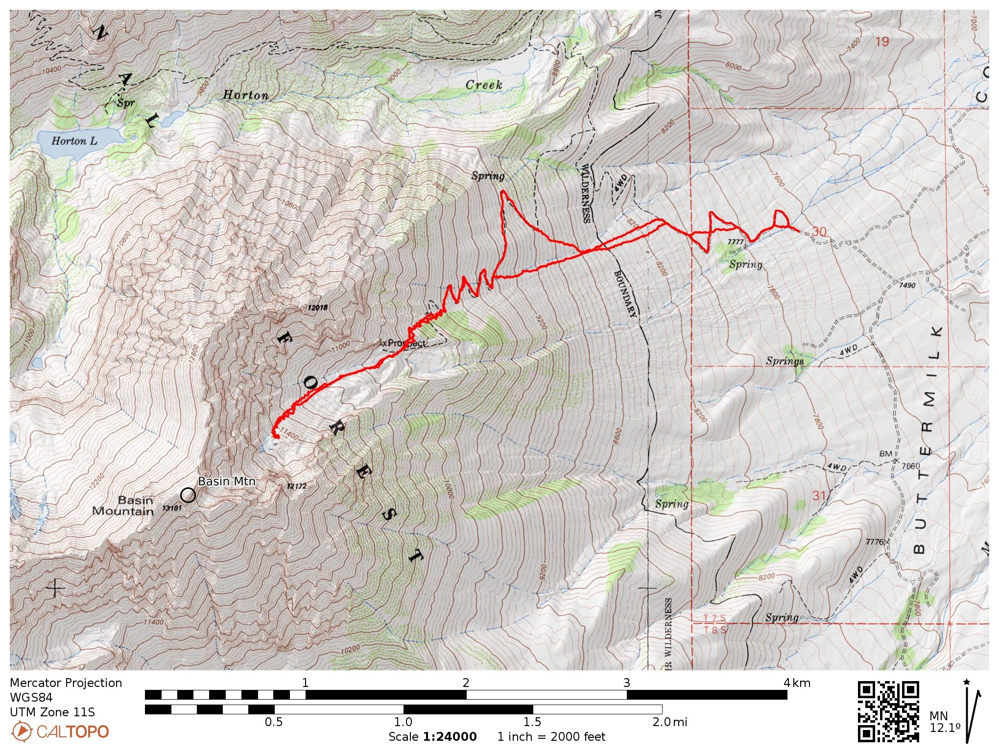
Specs (Up to mid-couloir at 11.5k ft): 7.7 mi | +/- 3900 ft
Difficulty: Class 1 [ratings] (To reach the summit requires class 3, 4, or 5 climbing)
Location: Inyo National Forest, CA | Home of Northern Paiute people | View on Map
Route: Drive along the Buttermilk Road until you reach the turn off to the Horton Lakes Trailhead, marked with a sign. Road conditions change with the season and year, but we had no trouble reaching the aspen grove below the trailhead in a Subaru Outback. We didn’t go farther because turn-around spots become infrequent, and the road had a few big rocks that would have been tricky.
From the trailhead, you can hike up the road/trail, but we took a more direct route, bee-lining up the slope to the switchbacks in the trail. Once we reached the snowline, we skinned up to a ridge and then hiked down over dry talus into the couloir. Once you reach the couloir, just go up, you can’t miss the excellent ski slope in front of you!
Permits & Regulations: Overnight travel in Inyo National Forest requires a permit (see Recreation.gov), but day trips are free from that red tape. Otherwise, the usual regulations apply: no campfires above 10,000 ft, food must be stored in bear-proof containers, etc.
Resources: Check the Horton Lakes Trail page for up-to-date USFS information. The Bishop Climbing Report often has notes about the continuously variable condition of Buttermilk Road. For more information about the skiing options, refer to the excellent Backcountry Skiing California’s Eastern Sierra by Nate Greenberg and Dan Mingori.
Late Spring on Basin Mountain
17 Apr 2026 | 7.7 mi | +/- 3900 ft | View on Map
Maddie and I leave our campsite in Bishop a little before sunrise and drive out to the Basin Mountain Trailhead on Buttermilk Road. If you’ve been out that way before, you’ll know that Buttermilk Road begins as a wide, smooth, dirt road. However, as you drive uphill, the road narrows and becomes rockier and more uneven. We stop about half a mile short of trailhead when the rocks become too large for the Subaru and load up our packs.
We’re hiking at 7 AM, trekking along the dirt road with skis and boots strapped to our backpacks. The road switches back up the hill, and we cut a few of the turns to make a beeline for the trailhead sign. High above on the hillside we can see more switchbacks — the uppermost reaches of the “road,” long overgrown by brush and thickets of trees. While we could stay on the road and gain elevation gradually, we’re in a hurry to reach the snow and decide instead to hike directly up the hill.


After trudging up 1400 vertical feet, we reach the high switchbacks and, worn out from the climb, follow them for another 600 feet to the snow at 10,000 feet. I’m surprised at how difficult the elevation feels; normally I’m not this out of breath until I reach 12,000 feet.
We pop into our skis and begin skinning uphill on firm, icy snow. Maddie was smart enough to put her ski crampons on right away; I’m forced to slip them into their slots mid-slope. Maddie follows a skin track that winds through the trees, up the steep slope. She seems to have no problem with it, but I’m struggling to keep my skis from slipping, even with ski crampons.
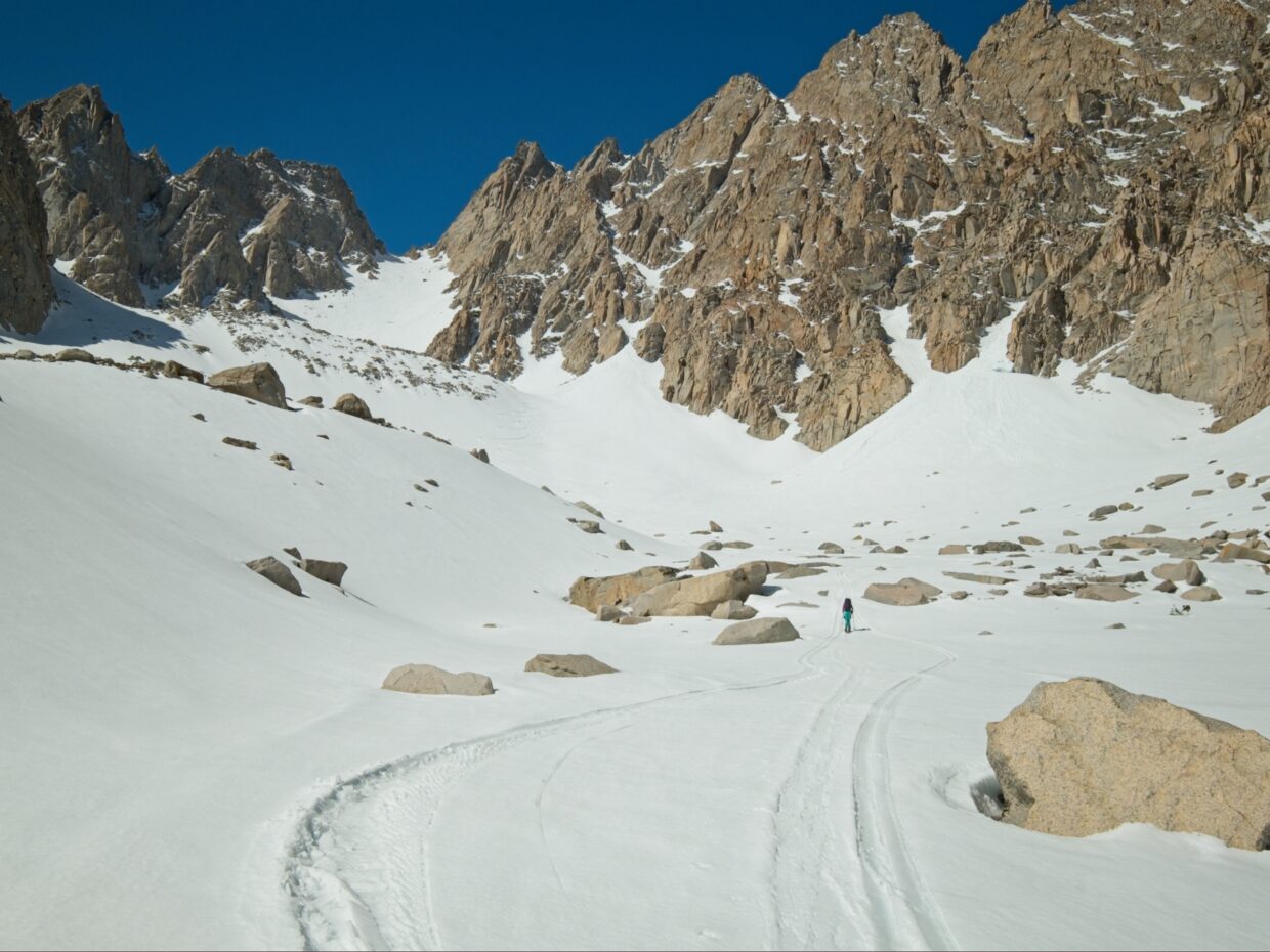
We reach the top of the steep, tree-covered slope at 10,500 feet and glide to the south aspect, where we find dry talus between us and Basin Couloir. So we pop out of the skis and carry them a few hundred feet across the talus, tottering in our ski boots on the rocks.


Thankfully, the couloir above us is both less steep and has softened up a little in the sun, so skinning uphill feels considerably easier. Breathing, on the other hand, continues to feel difficult. I slowly fall behind Maddie as we skin from 10,500 to a small rollover (a buried terminal moraine?) at 11,500 feet. By the time I arrive, my legs are exhausted. I’ve also noticed that the snow is quickly transitioning from corn to mashed potatoes, so I suggest to Maddie that we turn around here and ski down while there’s still some fun to be had. Looking up the couloir we can see tracks from recent riders and huge amounts of wet, loose debris they released while riding; even if the snow stays nice, riding through all those chunks won’t be very fun. And, perhaps more importantly, I’m not sure my legs will survive another thousand feet of ascent and then 2500 feet of skiing in what will likely be sticky, slushy snow. Neither one of us likes giving up on a peak, particularly after we’ve come so far, but we misjudged the timing today. We should have started a few hours earlier, though that wouldn’t have done anything to strengthen my legs or remove the riders’ debris.


So, after snacking and relaxing for a few minutes, we strip the skins and begin skiing downhill. The first few turns are hard — the snow is already sticky up here — but a little lower down the slope we enjoy speedy spring skiing! Despite having to stop every few hundred feet to catch my breath, I have a great time skiing the lower couloir.
When we reach the dry talus, we pop out of our skis to clamber back up to the ridge, and then click back in to ski down to the road. I enjoy this final slope much less than the couloir. The snow conditions are incredibly variable: wet and fast, wet and sticky, corn, patches of ice, and breakable crust, all within a hundred feet of each other. Add to that inconsistency a bunch of trees, plus logs and rocks protruding from the thin snowpack, and you get “survival skiing,” which is not something I particularly enjoy. Still, it’s faster and less tedious than booting down the hill.
I return to the spot where we began skinning this morning, but Maddie remembers to look farther right for continuous snow and manages to descend one or two hundred feet lower. The routefinding is tricky enough that it takes her just as long to ski that stretch as it does for me to hike down to her on the road.


Rather than beelining down the hill, retracing our ascent route, we follow the road for a few of its long switchbacks, thinking that the shallower grade will be easier on our knees and we’ll be less likely to bang our skis against rocks or catch them in bushes. However, after pushing our way through fifty feet of dense new-growth trees, we abandon the road and hike downhill through the brush anyway. We reach the car at 2 PM and, after piling our gear into the car and changing into cooler clothes, head into town for some hot food.
Although we’re both confident we made the right choice to turn around mid-couloir, falling short of the summit is going to nag at us. Next time we’ll get an earlier start and, with any luck, have a little more snow than this year.