
The past month my work schedule has been incredibly uncertain. So when I had some assurances that my presence would not be required this weekend, I snatched a walk-up permit for the South Fork of Big Pine Creek in Inyo National Forest. Besides wanting to get away from town for a change, I was desperate for some cooler temperatures. Los Angeles has been baking in 100+°F heat for a week or two; surely it will be more comfortable up in the mountains! As luck (or misfortune) would have it, the weather forecast for the weekend predicted lots of rain, but I decided to go anyway.
Trip Planning
Specs: 18 mi | +/- 8600 ft | 1.5 days, 1 night
Difficulty: Class 3 [learn more]
Location: Inyo National Forest, California | Home of the Eastern Mono and Northern Paiute peoples | View on Map
Route:
- Route to Elinore Lake [Class 2] Begin on the South Fork trail and hike to the sign that marks the split between Brainard and Willow Lakes. Take the path toward Willow Lake, following cairns north for a few hundred yards and then west across a meadow and three different creeks. Continue following the cairns up the South Fork of Big Pine Creek, staying mostly on its south side except for a particularly willow-choked meadow which is most easily passed via talus on the north side of the creek. A little higher up, follow the outlet creek (the cairns stay a bit south of the creek) up to Elinore Lake.
- Approach to Temple Crag [Class 2] If you hiked all the way to Elinore Lake, backtrack to the confluence of the Elinore Lake outlet with the creek flowing down from below Temple Crag. Cross to the north side of the creek and scramble up loose scree to a stable talus field. Make for the southeast flank of the mountain a few hundred feet west of Contact Pass.
- Temple Crag via Southeast Chute [Class 3] Scramble up ramps that trend eastward to a chute. Continue up the chute and then up a wide talus field, staying to climbers’ right of the pinnacles. A very short section of exposed class 3 rock leads to the summit.
Permits & Regulations: Permits are required for all overnight trips in Inyo National Forest and you must store your food in a way that prevents bears or other animals from getting to it. As always, practice leave-no-trace when you’re out in this beautiful wilderness!
Resources: The South Fork of Big Pine Creek page includes lots of useful information – check the sidebar for current Forest Service alerts and closures. Since this route crosses several large creeks, I recommend getting as much information about current conditions as you can, e.g., via trip reports on PeakBagger.com.
Hike to Elinore Lake
09 Sep 2022 | 5.6 mi | +3700 / -300 ft | View on Map
It’s not as cool as I hoped in the mountains. The car thermometer reads 80°F but it’s only 12:00, so the temperature is bound to increase. Still, it was 98°F down in the valley, so I’ll take 80. I’m parked at the overnight trailhead parking a little less than a mile from the trailhead. I munch on a sandwich from the Port of Subs while I stroll over the the trailhead, depositing the wrappings in a trashcan before starting down the trail.
The sun shines brightly overhead in stark contrast to the forecast for clouds and rain this afternoon. In fact, I don’t see any clouds whatsoever. I wouldn’t mind a little shade, but I’m not going to complain about clear skies; maybe tomorrow will be less gloomy than forecast too?
For a few minutes I stroll along a shaded road that provides access to a handful of private cabins near the trail. But the path soon climbs up the hill and makes a beeline for the wilderness. I pass the junction with the North Fork trail and quickly depart the shade for open hillsides. Splashes of fall color dot the hillside; combined with the still-blooming wildflowers it’s a beautiful sight!
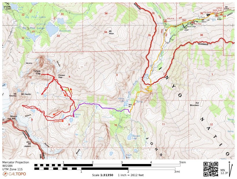
About one and a half miles up the trail I cross the South Fork, a rather large creek, by hopping across a few boulders protruding from the water. A short distance later, I begin up a series of switchbacks, gaining about 1200 feet of elevation up to a small ridge overlooking Willow Lake with sweeping views of the southeastern section of the Palisade Mountains. It’s a lovely sight, though not quite as nice as the alpenglow view Craig and I got last summer when we hiked up here early one morning to climb Balcony Peak.
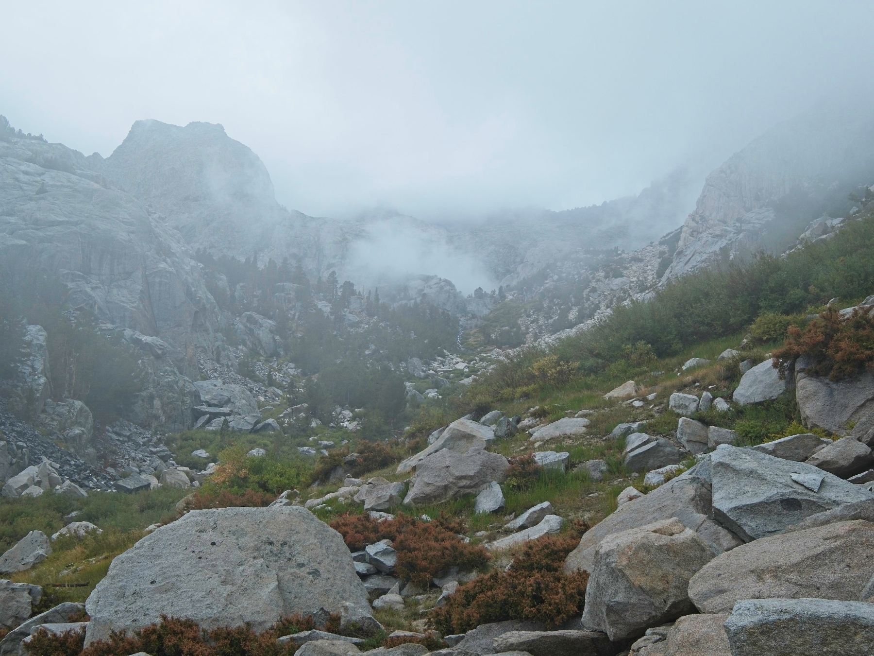
I leave the maintained trail at about 13:30 and strike out cross country toward Elinore Lake. The route is pretty well marked by cairns, though they’re frequently small and not immediately obvious. Luckily, I remember the route well from last years’ hike up to Palisade Crest and quickly navigate through a series of granite slabs and an overgrown meadow, crossing three tributaries to the South Fork.
Beyond the meadow, I follow a use trail through a fern-covered forest, then into a drier, more open forest, keeping to the south of the roaring creek. The route finding is a bit trickier in the denser sections of the forest, but cairns abound, so the key is to keep looking for them. At the base of a valley that leads up to the Norman Clyde Glacier, I cross the South Fork via a few boulders and a dense log jam beside a huge meadow. It looks like the kind of place you might find a moose, if moose lived in the Sierra Nevada.


After the creek crossing, I hop across boulders for few minutes and then cross the creek again where a few massive rocks provide easy passage (again, lots of cairns). I scramble between some truly massive boulders (the size of a small school bus) and through a thick patch of willows to reach a shallow wash. Cairns lead the way up the wash, eventually leveling off at a series of granite slabs. Just ahead, the outlet creek from Elinore Lake gurgles through the forest, so I turn left and scramble up talus the rest of the way to the lake.
I arrive at about 15:00, thoroughly wiped from the climb. It’s been four or five weeks since I carried a heavy pack, but I suspect the bigger culprit is the altitude. I’ve traveled from roughly sea level in LA to 8000 feet at the trailhead and am now at 11,000 feet! My earlier thoughts of dropping gear and climbing a peak this afternoon now seem ridiculous; I’m going to spend the rest of the day relaxing.
With nowhere else to be, I take my time setting up camp. I drank almost all of my water on the way up, so I wander down to the lake to fill up my bottles. As I walk past the outlet creek I’m a little alarmed to see globs of slimy, peach-colored moss covering the rocks; the lake itself is less mossy, but still a distinct shade of green. Hopefully it’s not one of those toxic cyanobacteria blooms… I’m too tired to go find other water, so I fill my bottles and make sure to add plenty of purifying chemicals back at camp.
To while the afternoon hours away I alternate between reading, listening to a podcast, and napping. When evening rolls around, I cook some dinner and then wander around with my camera for a while. A few wispy clouds catch some color at sunset but otherwise I don’t snap many pictures. Once the color fades from the sky I return to the tent and call it a night.
Temple Crag and Mount Gayley Attempts
10 Sep 2022 | 12.4 mi | +4900 / -8300 ft | View on Map
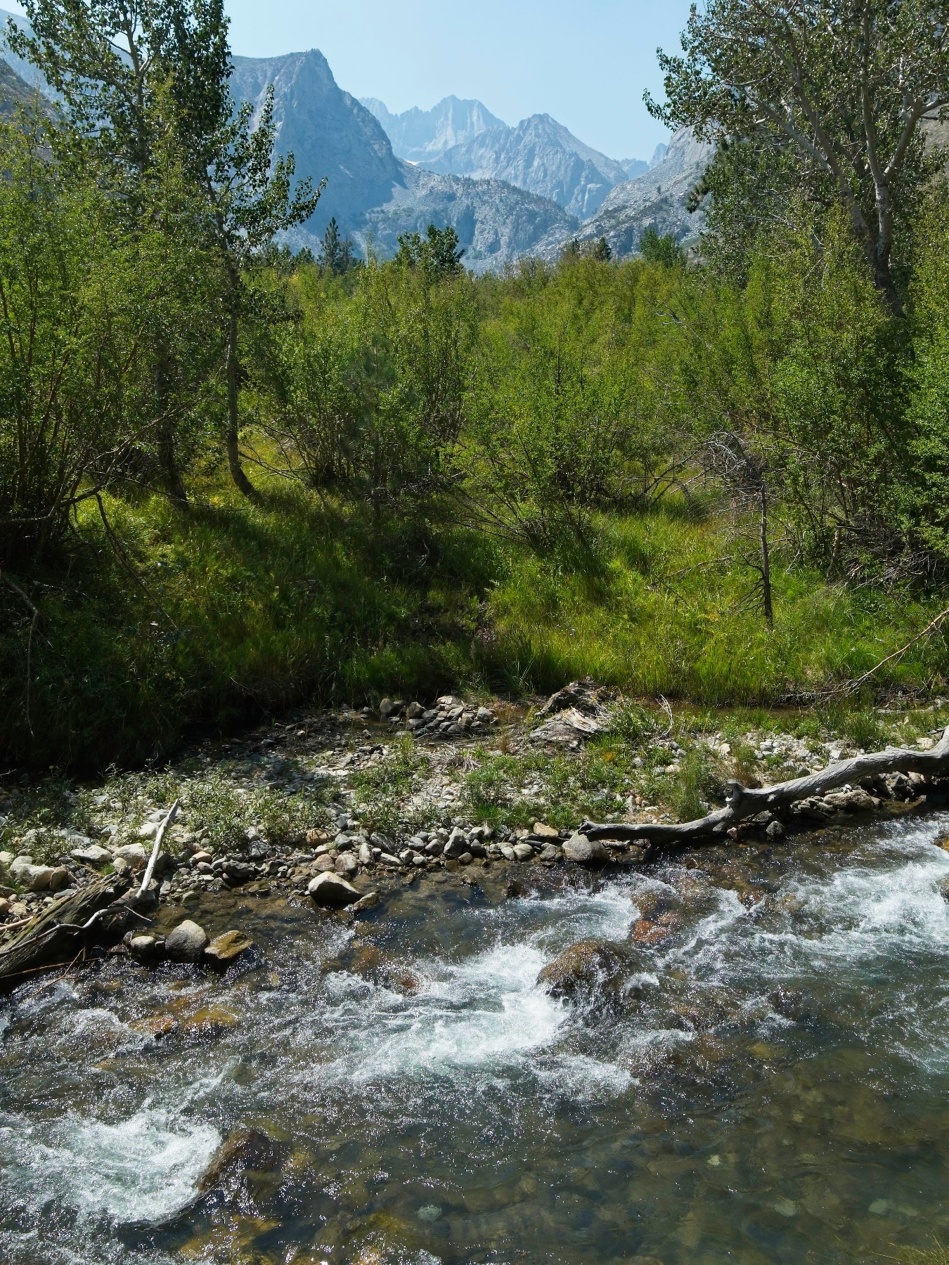
As a result of my early bedtime last night, I’m wide awake by 4:30 this morning. The sun doesn’t rise until at least 6:15, so I stay in the tent for another 30 minutes before giving up on resting. I cook some oatmeal in the pre-dawn gloom and try to gauge the weather. I can see a few stars overhead, but it looks like the rest of the sky may be covered in clouds.
By the time I start walking at 5:45, there’s enough light to see that the mountaintops are mostly covered in clouds. It appears the weather forecast was right after all, at least about the overcast skies. I suspect the cloud cover is responsible for the unusually warm temperatures and high humidity; no brisk temps at 11,000 feet this morning!
I’ve decided that my first objective for the day is Temple Crag. It’s a tiny bit closer to camp than Mount Gayley and the climbing sounds a little more difficult. Both Gayley and Temple Crag are class 3 scrambles, but Temple Crag has some exposed sections up top that I’d rather do early in the day before the weather gets any worse. To reach Temple Crag, however, I must first descend a few hundred feet to a point where I can get around a cliff-covered ridge. Besides crossing some slippery rocks, it’s a straightforward hike over to the northernmost creek in the South Fork drainage.
I spend the next 30 minutes scrambling up a tedious, loose slope. Thankfully, the top of the hill is covered in less tedious, stable talus. On the way to Temple Crag, I stop at a small pond to refill my water bottles. I didn’t enjoy the odd-tasting lake water last night so I intentionally put off a refill until I could find a cleaner water source like this one.


After stocking up on water, I scramble up the talus to the foot of Temple Crag. Secor describes the beginning of the climb as a chute to the left of Contact Pass. I don’t see a chute from the ground level, but there are some obvious slabs and ledges to climb up, so I begin with those (a GPX track from a previous climber also follows this route). A bit of class 3 climbing leads me over into a very obvious chute, which I slowly plod up. The clouds come and go, obscuring both the mountain above me and the valleys below. I find the conditions rather pleasant and calming. There’s not much to see, and it’s cool, breezy, and quiet.


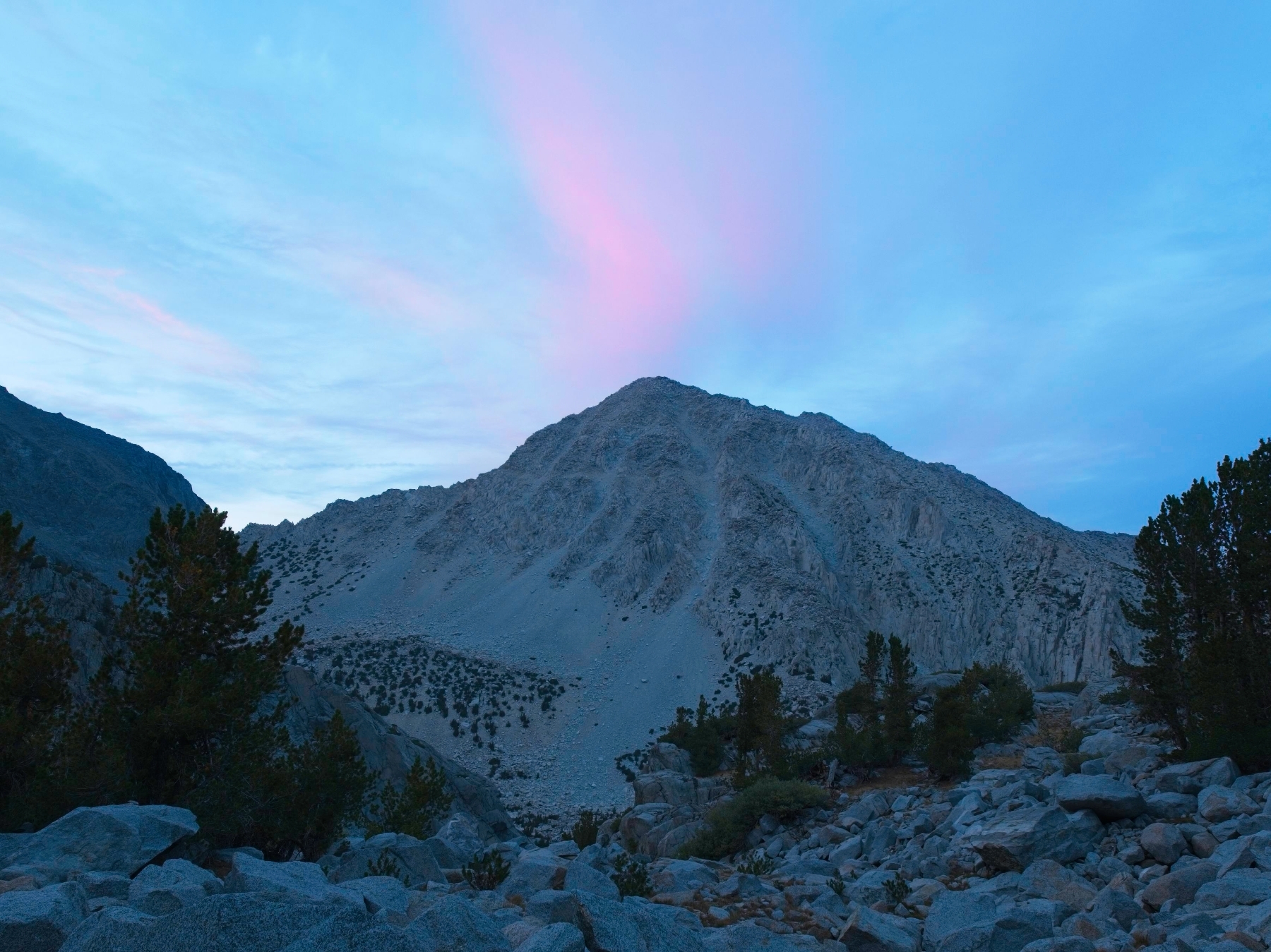
The chute opens up onto a wide talus slope at about 12,300 feet and visibility continues to decrease. I catch occasional glimpses of some pinnacles above, but am mostly just walking in a sea of white. I follow the GPX track up the mountain, slowing down as my body struggles with the thin air. After what feels like a very long time, I reach the top of the slope and peer over a short step at a steep drop off. This must be the exposed section Secor mentions in his book! It’s definitely exposed, though I can’ really see how far the drop is… it fades into gray like everything else. I can see the hand and footholds just fine though, and they’re large and easy to accerss. So I scramble over the rock step and carefully climb across the exposed face. A few more exposed class 3 moves are required, but it’s not a very long climb to the summit.
I’m surprised to find the summit register notebook sitting on out in the open with the protective box closed and latched beside it. I guess someone just forgot to put it back? I spend a few minutes flipping through the pages, finding a few names I recognize, before signing it myself. I wish I could see the landscape around the mountain (surely the views from such an exposed peak are excellent!) but I can’t help but admire the minimalist scene with the summit ridge fading into the mist.
After relaxing for a few minutes, I scramble back across the exposed ridge and descend the way I came up. Clouds continue to drift across the mountain, sometimes clearing enough that I can see to the foot of the chute. When I reach the base of Temple Crag, I pause to eat a snack and hopefully catch a glimpse of the plateau below Temple Crag and Mount Gayley. My plan is to walk across the plateau, climb Gayley, and then descend a more direct route back to Elinore Lake. By a stroke of good luck the clouds clear for a few minutes and I get a look at the route!
I set off across the plateau, enjoying easy, flat walking for the first time today. I’m savoring the quiet, gloomy atmosphere when I notice a thick cloud billowing up from the valley below. A few moments later, rain begins to fall. At first it’s just a light drizzle but the intensity quickly increases and I hurry to pull on my rain coat before I get too wet. Then the moment I’ve been dreading all morning: thunder reverberates through the mountains.


There’s nothing to do but turn around. I can’t see more than 20 feet in any direction and haven’t noticed any good spots to shelter from a storm, so I retrace my footsteps as closely as I can. Within a few minutes my pants and shoes are soaked but my upper body stays dry underneath the rain coat. The coat also protects me from a few fierce spats of hail.
Descending talus blocks in the rain proves to be more straightforward than I would have thought given the amount of water falling from the sky. Thank the gods for rough Sierra granite! Still, I do slip a few times on the way down, leaving a couple bruises on my hip and leg. The rain continues for about an hour and I count 24 distinct thunderclaps. At the height of the storm they occur once every few minutes but grow less and less frequent. They skies eventually begin to brighten, the rain turns into a drizzle, and then even the drizzle fades away.
By the time I reach the outlet of Elinore Lake, I spot the sun shining through a thin layer of clouds. The clouds have also receded from the mountains and I can see the tips of the Palisades for the first time today. Maybe it’s done raining? With plenty of daylight left, I decide to give Mount Gayley another attempt. Sure, I’ve descended 1300 feet during the storm, but I can make that back up in an hour or so.
Rather than returning to Elinore Lake, I turn west and scramble up a series of granite ramps and ledges. Partway up the ridge I stop for a few minutes to eat lunch and give my feet some time to breath. I peel off my shoes and socks, wring the water out of them and lay them out in the meager sunshine. Needless to say, they don’t dry much during the 15 minutes it takes me to eat lunch so they’re still plenty soggy when I pull them back on.
After eating, I continue up the slabs, heading for the westernmost point of the cliff-covered ridge. Several grassy ramps provide easy access to the talus slopes above, and I make good time. I keep an eye on the clouds, which have descended again to cover the mountaintops, a sign that more rain is coming. However, the clouds seem to be staying at a consistent altitude, which (in my experience) doesn’t necessarily mean a storm is nigh.


With the weather ever in mind, I continue upward toward Mount Gayley. The altitude makes it tough for me but I struggle along as quickly as I can maintain. At last I reach the foot of Mount Gayley and scan the area for a route to the ridge. Several cairns catch my eye, but I’m not sure that I see a consistent route. In any case, the walls in front of me don’t look harder than class 3, so I begin up a chute. About 20 feet up I feel raindrops on my hands and stop climbing. I’m so close to the summit and want to keep going, but I know it’s a dumb idea. I sit for a few minutes as the rain slowly intensifies before deciding I had better bail.
This time I’m better prepared for the rain. I spotted an enormous overhanging slab a few hundred feet down the slope, so I scramble down and take shelter underneath. Thunder again echoes through the valley, making me doubt my hiding place; electricity tends to arc between sharp edges, and there are lots of those between my feet and the rock just above my head… I stay put, figuring that my chances of getting struck by lightning are just as high out on the talus as they are under this flat rock.
While I wait for the storm to subside, I do some mental math. This storm will likely blow itself out just like the previous one with a window of fair weather afterward, and it’s been about 2 hours since the last storm ended. I’m no meteorologist, but I figure another storm will roll through in a similar or shorter amount of time this afternoon. Given my current elevation and the amount of class 3 terrain between me and the summit, it’ll take me 60 – 90 minutes to reach the summit and the same amount of time to return to this spot. In other words, I’m guessing the probability of another storm while I’m on the exposed ridge above 13,000 feet is high. It’s a disappointing conclusion, but the mountain isn’t going anywhere; I’ll just have to come back.
Thankfully, this rain storm doesn’t last as long as the last one. I count only 5 bursts of thunder, and the intense rain dies down to a light drizzle within 30 minutes. Emerging from the shelter of the slab, I look up at Mount Gayley wreathed in cloud for a few moments and then trudge off down the hill. I backtrack to the cliff-covered ridge and then follow a grassy ramp down to Elinore Lake. The scenery is nice, particularly the golden grass contrasted against the cool blue hues on this overcast day.

I arrive back at camp at about 15:00 amidst a new bout of rain (I was right about the timing!). After fetching my bear can, I crawl into the tent and begin to pack up. I’m careful to keep my warm layers and sleeping bag dry, but most of my other gear is somewhere between damp and soaked at this point. Although I have plenty of food to stay out here through tomorrow night, I’m tired of being wet and there’s no guarantee that I’ll have a third chance to climb Gayley tomorrow morning. I’m also a little worried about the creek crossings on the way out and don’t want to wait for even more rain to swell their flow any more than it already has.
Within 30 minutes I’m packed and ready to go. It’s still lightly raining, so I keep the rain jacket on and begin scrambling down the talus beside the outlet creek. For a little while the rain holds off, but soon I spot another billowing cloud rising up from the canyon below. Just like this morning, the cloud brings torrential rain and low visibility. I don’t bother stopping though; my shoes and pants are already soaked through. My only hope of getting dry is making it back to the car.
When I reach the first creek crossing beside the large meadow I’m a little alarmed to find that it’s risen by 6 – 8 inches, submerging some of the rocks and logs I used to cross yesterday afternoon. There doesn’t appear to be another crossing nearby, so I wade into the water, feeling for the rocks I know are there with my trekking poles. The crossing ends up being easier than it looks, and I’m soon squelching through the trees on the opposite bank (south side).
The downpour persists for most of my hike to Willow Lake. I follow the same use trail as yesterday afternoon and am grateful that I don’t have to fuss around with route finding in the pouring rain. Like the higher creek crossing, the three tributaries in the meadow above Willow Lake are all swollen with the day’s rain and I end up wading through two of them. I spot three backpackers scrambling up the talus to the north and silently wish them good luck on wherever they’re headed; they’re certainly not on the established route up the canyon.
Back on the maintained trail at last, I hurry down the switchbacks to the lower South Fork canyon. It’s smooth sailing until I reach the final creek crossing. My preferred string of rocks is mostly submerged and I’m not willing to wade through this one. The rocks are just above a deep pool and the water is moving really quickly. I start out across a second string of rocks but turn back when I realize the gap between two of them is much wider than it appears from the bank. I wander upstream a little ways, hoping to find a path across the creek where it spreads out over an alluvial fan. Unfortunately, the banks are overgrown with thick trees and I can’t find a way through.

So I walk back to the main crossing and then try a spot downstream. It’s slightly wider (thus, likely shallower), but I can’t tell for sure because the rushing water is opaque with sediment. With no better option, I decide to try wading across; it’s either that or camp here and hope the water is lower in the morning. With help from my trekking poles, I’m able to avoid the deepest spots and make it across through knee-deep water.
Thankfully, the rest of the hike out is creek-crossing free. By the time I reach my car at the overnight parking area, the sun has set and it’s beginning to get dark. I’m reminded of my first (and previous) trip here, which also ended with Craig, JT, and I hiking out in the dark. Perhaps next time I’ll manage to make it out with some daylight left.
Steve Cox 29 September 2022
Oof – despite the gorgeous pictures, it sounds like this was a bit disappointing. I’m always glad you make smart choices and avoid danger, though! Thanks for the fantastic writeup and pics, as always!