It’s difficult to plan ahead for a November backpacking trip – the conditions can range from sunny and 50 degrees to ten degrees below freezing and feet of snow on the ground. As Thanksgiving approached, it seemed like Yosemite would mostly have the former, but we weren’t sure. Several inches of snow fell the weekend of Nov 18 but webcam images from Glacier Point showed it melting relatively quickly. However, without new Sentinel 2 satellite imagery of the area we’d be hiking through, we were still gambling. That’s half the fun though; leave some room for surprise!
Trip Planning
Specs: 29.5 mi | +/- 6700 ft | 3 days, 2 nights
Difficulty: Class 1 [learn more]
Location: Yosemite National Park, California | Home of Me-Wuk, Miwok and Northern Paiute peoples | View on Map
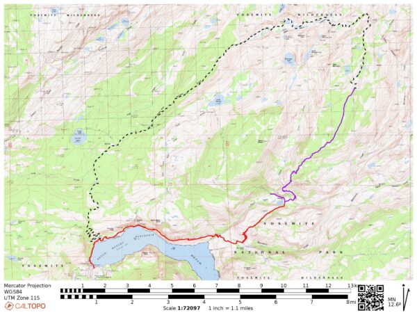
Route: We planned to complete a 32-mile loop from the O’Shaughnessy Dam to Tiltill Valley, up through Jack Main Canyon, and back to the start via Beehive Meadow. We modified that plan on day two when we discovered more snow, ice, and frigid conditions than we were expecting and turned the trip into an out-and-back with two nights at Tiltill Valley.
Permits & Regulations: Wilderness permits are required for all overnight trips in Yosemite. As of the time of publication, the permits are self-issued between late October and mid-April and you don’t need a reservation to enter the national park. However, these dates and regulations change over time, so check the national park website for details.
Resources: The Yosemite National Park backpacking page has links to all the information you need! For navigation, I recommend that National Geographic map of the park.
Hetch Hetchy History
Only 100 years ago, the area that is now Hetch Hetchy reservoir was a sprawling meadowland that rivaled Yosemite Valley in grandeur. The transformation to a reservoir has been and continues to be a controversial issue.


Humans have lived in Hetch Hetchy valley for over 6000 years. The valley was a summertime home for the Miwok and Piute people for millennia; they hunted and gathered edible seeds and plants from the vast meadows that they maintained via controlled bushfires [Jones, 2010]. The valley name is said to be derived from the Miwok word anglicized as hatchhatchie, meaning “edible grasses,” a reference to the indigenous use of the valley [Farquhar, 1926]. Early white visitors to the valley didn’t realize the sweeping grasslands were engineered, however. Instead, the believed “the valley was purely a product of ancient geological forces (or divine intervention)” [Bibby, 2006].
Interest in using the valley as a water source dates back to the 1850’s. In particular, the city of San Francisco hoped to use Hetch Hetchy as a reservoir to bolster their unreliable water system [wikipedia]. They tried to acquire the water rights to the valley in the early 1900’s but faced opposition from environmental and conservation groups. It wasn’t until after the 1906 earthquake and subsequent fires revealed the inadequacy of the city’s water system that the political scales tipped in their favor.
Work to convert the valley into a reservoir began in 1914 with the construction of the Hetch Hetchy Railroad [Tuolumne County Historical Society, 2015]. Construction on the O’Shaughnessy Dam began in 1919 and concluded in 1923; the dam was 227 feet high. Later, in 1938, the dam was raised to 312 feet, it’s current height. When full, the reservoir holds around 117 billion gallons of water that is supplied to the bay area and is also used to power hydroelectric generators.
Although the reservoir is beautiful in its own way, its existence within a national park (dedicated to preserving wilderness for public access) is a strange juxtaposition. Not only is the flooding of a valley important to native people very “anti-preservation,” but recreation in or even near the reservoir is strictly prohibited by the water managers. The Restore Hetch Hetchy organization, among others, advocates for the restoration of the valley to it’s pre-reservoir form. Imagine a second Yosemite Valley! Those that oppose restoration point out that the reservoir is a valuable source of fresh water for millions of people and that it supplies renewable hydroelectric power. But the dam won’t last forever and the need and/or public will for the reservoir continues to shift. Perhaps when it can no longer be maintained, the dam will be breached and the valley will return to a wilder form.
Sources
- Jones, Ray (2010). It Happened In Yosemite National Park: Remarkable Events That Shaped History. Globe Pequot. ISBN 978-0-7627-6231-6.
- Farquhar, Francis (1926). Place Names of the High Sierra. pp 39
- Bibby, Brian (2006). Scott, Amy (ed.). Yosemite: Art of an American Icon (section). University of California Press. ISBN 0-520-24922-4
Thanksgiving in the Backcountry
23 Nov 2023 | 9.2 mi | +2900 / -1100 ft | View on Map
Kenza and I arrive at the Hetch Hetchy backpacking camp around 11:00. It’s a beautiful fall day: sunny and cool with a light breeze. Another group of five or six backpackers is busy shuffling their gear around when we pull up and we chat with them a little as we pack our own bags. They’re hiking the same direction as we are but are stopping at Rancheria Falls; we’ll hike a bit farther and higher up to Tiltill Valley.
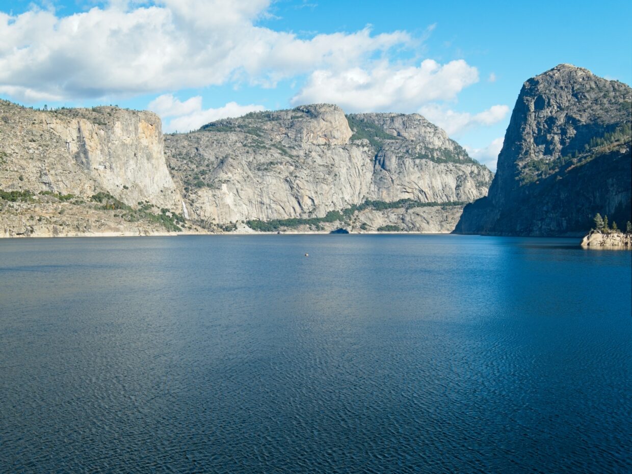
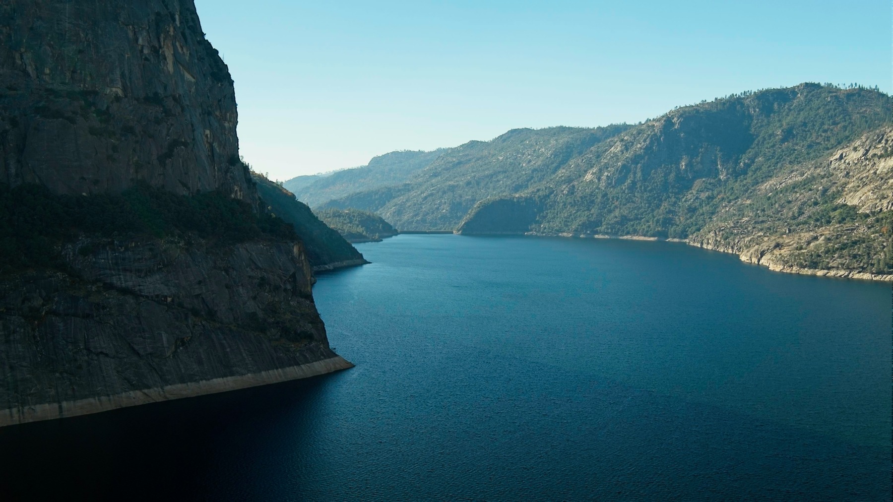
Once we have our bags packed the way we want them, we say goodbye to the other backpackers and walk through the backpacker’s campground and down to the O’Shaughnessy Dam. I’m a little surprised to see a fair number of people strolling around; spending Thanksgiving in Yosemite National Park appeals to more people than I would have guessed. On the far side of the dam we walk through a long tunnel, emerging on the other side onto a wide dirt path. The path eventually narrows to single track as it winds along the rocky shore of the reservoir.


 towers over the water")
We pass lots of hikers on their way to or from Wapama Falls; it seems like the popular destination out here. Along the way we stroll through several picturesque groves of oak trees with fallen leaves and acorns covering the ground. We stop for lunch at the waterfall. It’s nowhere near peak flow this late in the season, but it’s still very impressive!


After lunch we continue walking around the reservoir. Besides a few small ups and downs, it’s a pretty flat walk and I enjoy the views of the reservoir and the fall leaves. Near Rancheria Falls we walk through a grove of pines, cedars, and oaks; the oaks are bright orange! There are lots of campsites scattered throughout the trees; it looks like a great spot to camp!


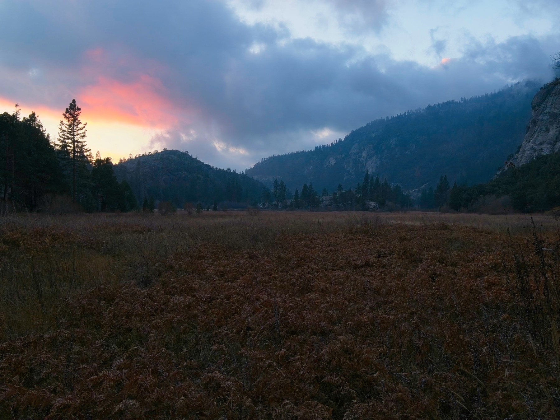
Our campsite is a few miles further, however, so we keep walking. The trail climbs about 1200 feet over the next three miles, switching back up the mountain. A light drizzle falls for five or ten minutes and, with the sun mostly behind us, we’re treated to a rainbow! By the time we reach the top of the climb, the sunset is at peak color and the whole world is orange and red. The light quickly fades though and we’re left walking in the blue-gray dusk.
I was expecting to find a bit of a creek up here but there’s no hint of flowing water. Kenza and I are nervous about that – we don’t have a ton of extra water. The encroaching darkness adds a sense of urgency, which doesn’t make a whole lot of sense when you think about it. It’s barely 5 PM, so we certainly have plenty of time to find a campsite, albeit with headlamps and moonlight instead of the sun.


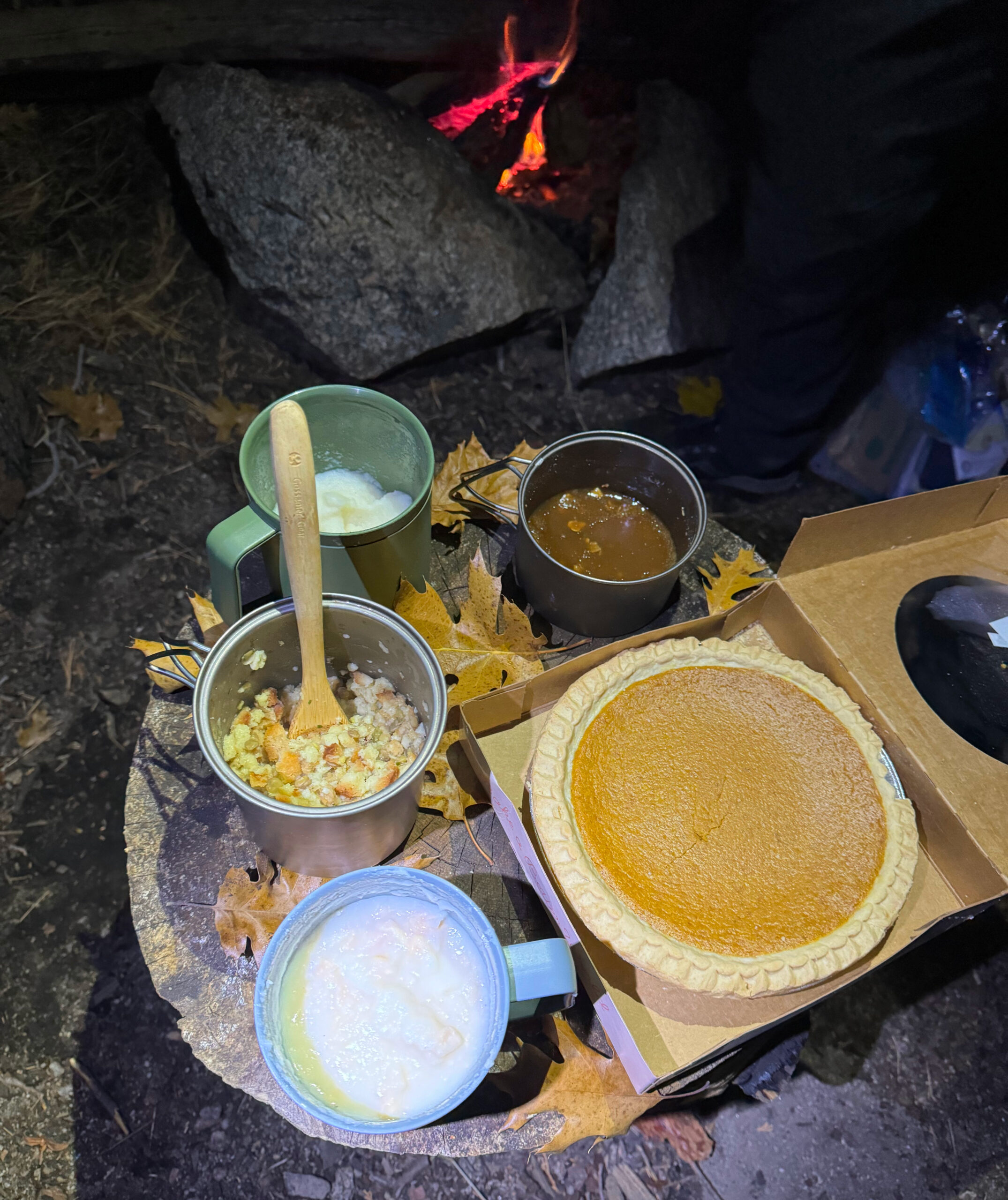
We reach Tiltill Valley at about 17:15. There are several pools of standing water, but I’d prefer running water. After checking the map, we decide to walk half a mile over to Tiltill Creek (it was flowing lower down the mountain). We do indeed find a large creek and some excellent campsites right next to it! Kenza and I set up our tents and then make a fire. It’s Thanksgiving, so we brought some “gourmet” food: mashed potatoes, gravy, stuffing, and an entire pumpkin pie. I could get used to this kind of holiday.
A Bid Into Snow
24 Nov 2023 | 11.1 mi | +/- 2700 ft | View on Map
One of the best things about Thanksgiving is leftover pie for breakfast, and today is no exception. Hot maple, brown sugar, and almond oatmeal plus chilled pumpkin pie… yum! Kenza and I pack up camp and then stroll back to the trail junction in the middle of Tiltill Valley that we passed in the dark last night. After checking the map, we hurry through frosty grass to the eastern edge where the trail begins climbing uphill.


Unlike the path we followed yesterday around Hetch Hetchy and up to Tiltill Valley, our trail today is faint, sometimes only barely visible in the long grass and fallen leaves. I love it; the hiking feels more adventurous and wild when the path is just barely visible! We hike through boulders and colorful oaks for a little while and then emerge into the warm sunlight on granite slabs. Once we’ve made it up seven or eight hundred feet, we’re treated to a nice top-down view of Tiltill Valley and a sliver of Hetch Hetchy.


After what feels like a very long time, the trail levels out a bit at 7000 ft and meanders through a forest of mixed pines, cedars, oaks, and aspens. The flat land doesn’t last very long, unfortunately, and we’re soon trudging up switchbacks again. Snow appears around 7700 ft, though it’s pretty patchy since we’re on a manzanita-covered south-facing slope. By the time we reach the top of the hill, topping out at 8000 feet, the snow covers every inch of the ground. Only a few sunny clearings are snow-free.


Kenza and I eat lunch in a semi-warm sunny spot and then continue up the trail through increasingly deep snow. At least one other person has passed this way since they snow fell last weekend; their footprints lead the way through the forest and are sometimes the only clear indication of where the trail is. Squirrel and rabbit prints also crisscross the snow in every direction. We cross over a completely frozen creek and then crunch through a few inches of crusty snow for a mile or two.
Around 13:15 we emerge from the cold, snowy woods onto a sunny rocky slope and take a break. I’m feeling nervous about continuing on our loop. There’s a lot more snow than I expected up here. We’re not really prepared to camp in or travel through deep snow. For example, Kenza and I are both wearing light hiking shoes, which are fine for light snow but it’s deep enough that it’s starting to get our feet wet. We’ve also got about six miles to go to reach our planned campsite and there are less than four hours of daylight left. We have done almost all of the elevation gain for the day, but we’re not all that fast in the snow… Kenza and I talk it through and decide it would be safest to turn back and camp in Tiltill Valley again. The point of this trip is to enjoy being out here, after all; there’s no big objective on the itinerary that warrants extra suffering. (In retrospect, and after looking at several different digital maps, we probably would have been out of the snow in a couple more miles and would have had plenty of dry, sunny spots to camp. But it’s hard to be sure!)


It’s a quiet walk back down the snow-filled valley. I’m pretty sure we made the right decision, but I’m still bummed that we won’t get to see Jack Main Canyon. I suppose this means I’ll just have to come back another time! The steep uphills that passed so arduously this morning are quick and easy now. I really appreciate the soft, spongy soil that absorbs the shock of each step. By the time we reach Tiltill Valley, the sun is setting, but we make it to the campsite near the creek before it’s completely dark.


Once we have the tents up, Kenza and I make a fire and spend the rest of the evening enjoying its warmth. I picked drier wood today and the fire produces a lot less smoke, which I really appreciate. I’m a little surprised at how much the fire warms the surrounding area too – it’s at least 10 degrees warmer within a few feet of the glowing coals! Once we’ve exhausted the stack of collected wood (at a respectable bed time of 20:30), we retreat to the tents.
Back to Hetch Hetchy
25 Nov 2023 | 9.2 mi | +1100 / -2900 ft | View on Map
My water bottles are partially frozen this morning, an indicator that it’s much colder than the past few days. There’s no pie for breakfast, but I still enjoy my hot oatmeal. After packing up, Kenza and I crunch through frosty grass on the edge of the meadow and stop a few times to admire the ice-crusted plants. I keep all my layers on while hiking this morning; if I had to guess, I’d say it’s in the low to mid-twenties.


After a short climb and a stroll through some shaded trees, we finally reach consistent sunshine at the switchbacks overlooking Rancheria Falls. I ditch a few layers here and then speed down the switchbacks. Kenza and I make a short detour for a look at the thundering cascade before continuing down the trail toward the dam. We see several groups of backpackers this morning, all of them heading for Lake Vernon. In the summer there’s a ranger cabin there, so it must be a popular area.
The rest of the hike passes by pretty quickly. It’s surprisingly warm in the sun, particularly since it was so cold this morning! I’m down to my base layer and wish I had cooler clothes. Once we reach Wapama Falls, the number of people increases tenfold, just like on the way out; that’s as far as the day hikers go. We reach the car an hour or two later and drive off to visit other parts of Yosemite.

