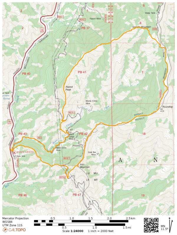
This difficult ten-mile loop alternates between desert bushwhacking and mountain road walking as it traverses between Iron Mountain, Round Top, Granite Mountain, and Rabbit Peak. There are no trail signs or other markers, so come prepared with a map! Because the loop follows the ridgeline, there is also no water and very little shade, so it’s best completed in the cooler months.
Trip Planning
Specs: 10.3 mi | +/- 4200 ft
Difficulty: Class 1 [learn more]
Location: Angeles National Forest, California | Home of Tataviam and Gabrielino peoples | View on Map
Route: Begin at the Monte Cristo campground and start walking up Forest Road 3N23. Almost immediately, turn right and hike up a faint, steep use trail that stays on the ridge that leads up to Iron Mountain. Take the right branch of the dirt road beneath the power lines to the southwest ridge of Iron Mountain and then hike up the firebreak to the summit. Continue down the firebreak on the north side of the peak and stay on or near the ridge, following the firebreak or dirt road as you please. To reach the summit of Round Top, just follow the firebreak to the top! A well-groomed dirt/gravel road will take you most of the way over to Granite Mountain, where – you guessed it – you can follow the firebreak to the summit. A very faint use trail descends the west ridge of Granite Mountain; it’s occasionally marked with cairns, but in general it sticks to the ridge. The same use trail climbs up to the summit of Rabbit Peak and then descends the south ridge. The descent can be steep and loose, so take care to avoid slipping and sliding. Follow the ridge down to the dirt road that parallels Monte Cristo Creek, and then take the road back to the campground.
Permits & Regulations: No permits are required to hike in this area and, despite the number of mines, I didn’t see any fences or “no trespassing” signs, so explore as you like. I didn’t look too hard for parking in the campground but there are 2 – 3 spots on the shoulder of the highway (forest adventure pass required). The campground itself has running water and vault toilets.
Resources: Due to the obscurity of these peaks, there aren’t many resources dedicated to them. The Monte Cristo Campground page is probably the best source of notices and alerts for the area.
Autumn in the San Gabriels
4 Nov 2023 | 10.3 mi | +/- 4200 ft | View on Map
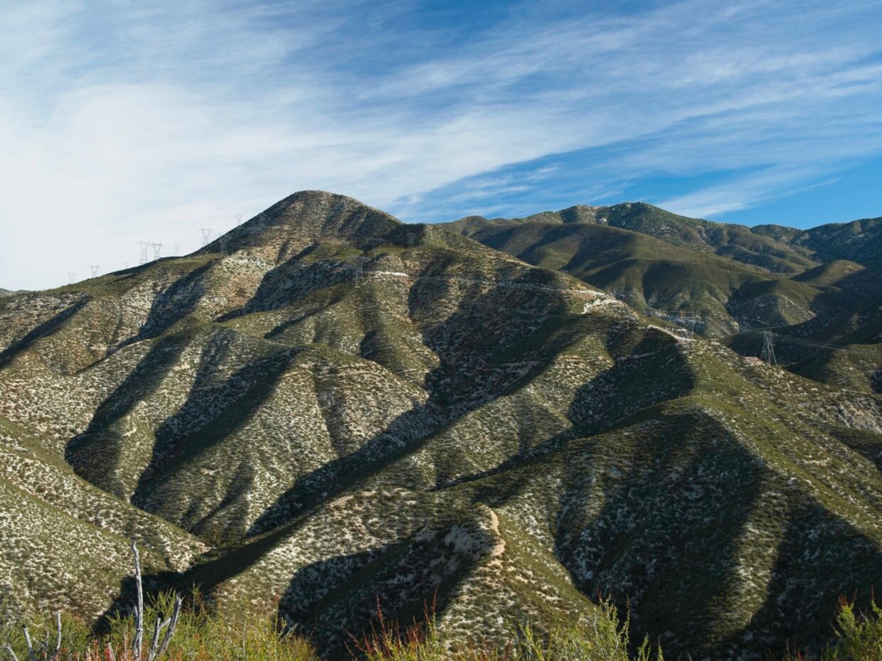
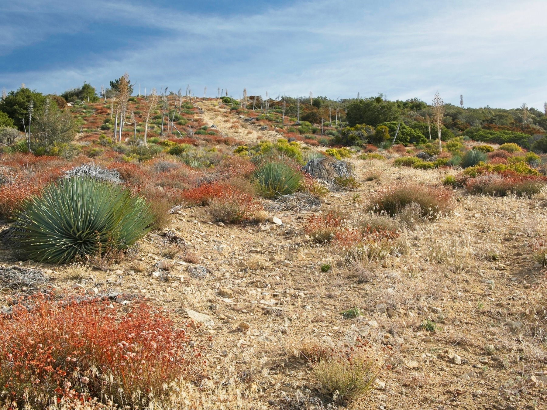
It’s a brisk 47 degrees this morning, the perfect temperature for a hike in the dusty, sun-baked San Gabriel Mountains. For a very brief moment, I enjoy strolling down a single lane dirt road (it leads to the Monte Cristo mine), but then reach the “trail,” a barely visible path leading steeply up the ridge. Six hundred feet of difficult hiking bring me to mellower terrain on the undulating ridgeline where I’m able to enjoy the views of the surrounding mountains. Lots of the plants are showing off their fall colors: rusty reds, oranges, and faded yellows contrasting against the similarly desaturated desert greens.


The summit of Iron Peak is pretty unremarkable, just a flat patch of dirt cleared of brush by fire crews. The entire ridgeline has been cleared as a firebreak, and serves as the “trail” for a good portion of this hike. On the way up, the loose soil can be a bit tedious, but it’s welcome on the way down!
I spot a few hunters in camo and blaze-orange hats on my way over to Round Top. I’m not sure if they see me, but I haven’t heard a single gunshot so I don’t bother yelling at them to make sure they know I’m here. My tan pants and sage-green sun shirt are camouflage out here in their own way; they almost perfectly match the sand and the chaparral.
The steep hike up to Round Top on the firebreak has me dripping sweat. It feels hot out here in the sun even if the air temperature is only 60 or 70 degrees. To add to the discomfort, a cloud of gnats and flies buzzes around my head. Occasionally the breeze picks up and provides some relief from the sweat and the bugs, but it’s not until I reach the upper slopes of the mountain that it becomes consistent enough to really help. On the way I spot some glittering crystals on the ground: quartz and flaky mica!


The Round Top summit is the end of a well-groomed gravel road. I’m not sure why there’s a road up here; the views are certainly nice, but there aren’t any radio towers or other infrastructure that need to be maintained. I sign the brand new summit register nested in two rusty tin cans and then walk down the road toward Granite Mountain.
The upper slopes of Granite Mountain host a different ecosystem than Iron Mountain and Round Top. Instead of dense chaparral there are pine trees and lots of long grass. It looks like someone has been up here clearing the grass away from the base of young trees that are coming back after the Station Fire (2009). I look around the summit for a few minutes in search of a register but don’t find one, so I walk over to find some shade in a pile of rocks and eat lunch.


The hike down from Granite Mountain to Rabbit Peak is a bit more rugged and fun than the other hiking so far. I spot a few cairns marking the way but am also able to follow footprints in the soft sand pretty easily. I reach another ridgetop firebreak a few hundred feet down the ridge and follow it for a bit, but it ends before reaching Rabbit Peak. The ascent up the north ridge of Rabbit Peak is quick and easy and I don’t pause at the summit; there’s no register here either.
Descending from Rabbit Peak to the dirt roads below is my least favorite part of the hike. The ground is hard and loose, which makes the footing very slippery and unforgiving. I teeter and slide down the ridge until I reach the dirt road and then abandon the ridgetop trail in favor of the road. I’m forced to do a little more bushwhacking (to avoid a very long, traversing road walk) down to Monte Cristo Creek but am then free to walk the road all the way back to the campground.