This spring I scored a four-person overnight permit for Mount Whitney. Thankfully, out of the ten date options on the application, I got a late season trip and avoided the huge amount of early season snow we had this year. I’ve been up Mount Whitney several times (main trail, JMT, Mountaineer’s Route) but I haven’t yet tagged nearby Mount Muir (14,012 ft), so this trip gave me an excuse to bring some friends along while also tagging a new peak. Margaret, CK, and Kenza joined me on this trip; it was the first time in the Sierra for all of them! We didn’t all make it to the summit, but I think everyone enjoyed the spectacular scenery regardless.
Trip Planning
Specs: 21.0 mi | +/- 7000 ft | 2 days, 1 nights
Difficulty: Class 1 [learn more]
Location: Inyo National Forest | Home of the Tubatulabal, Eastern Mono/Monache, and Western Shoshone peoples | View on Map
Route: Follow the trail to the summit.
Permits & Regulations: A permit is required for day use and overnight use. For overnight and single-day trips, you’ll need a Mt. Whitney Zone Permit. You are required to pack out your solid waste in the Whitney Zone (the forest service provides wag bags) and bear cans are required if you’re staying overnight. For a full list of regulations, visit the Inyo National Forest website.
Resources: The Mt. Whitney Facebook group has been an invaluable source of recent trip reports and photos. I recommend the National Geographic topographic map of the Mt. Whitney area; Tom Harrison also publishes a nice map.
Pancake Power
21 Sep 2023 | 6.4 mi | +3700 / -100 ft | View on Map
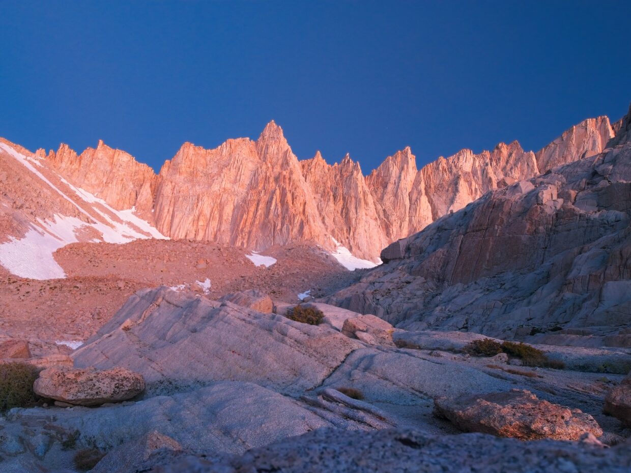
When we arrived at Whitney Portal last night I was shocked to discover that the campgrounds were completely empty. Granted, it was a Wednesday night in late September, but still, Mount Whitney is a hugely popular spot! We pitched our tents and got a full night’s rest at 8,000 feet, a good preparation for today’s hike to Trail Camp at 12,000 feet. It’s not a very long hike – about 6.5 miles – so we sleep in and then enjoy a breakfast of toast, hashbrowns, sausage, eggs, and two enormous pancakes at the Whitney Portal Store. By 9:00 we’re on our way up the trail.


It’s chilly this morning but sunny, so I’m soon warm enough to hike without any extra layers on. Margaret leads the way and sets a comfortable pace for the many switchbacks. About three miles up the trail we reach Lone Pine Lake and take a long break. Kenza and CK explore around the edge of the lake while Margaret and I lounge on the shore.


After re-applying sunscreen and munching on snacks, we continue up the trail and pass into the “Whitney Zone,” a.k.a., the poop-in-a-bag zone. The altitude is beginning to take its toll and we slow down considerably as we climb above 11,000 feet. A stiff, cold wind blows down the trail above treeline and I pull on a fleece jacket to stay warm. We stop for a break at Trail Meadow, a gorgeous little strip of grass beside the trail, but otherwise continue the slow march up into the rocks.


We arrive at Trail Camp around 16:00 and explore around to find a campsite that will offer some shelter from the cold wind. We’re not terribly successful, but we do have a nice wind-sheltered spot nearby where we can huddle and cook dinner. The sun sinks below the Sierra crest by 17:30 and the temperature really begins to drop. I pull on all of my layers while we eat dinner and then retreat into the tent as soon as possible. I wish it were warmer so we could relax and chat outside, but it’s much too cold for that.


Summit Day
22 Sep 2023 | 14.6 mi | +3300 / -6900 ft | View on Map
It was windy all night long and I don’t think any of us slept very well, but everyone at least stayed warm in their sleeping bags! Today is a big day, so we’re up early at 5:00. The plan is to hike up to the summit of Mount Whitney and then hike all the way out to the trailhead. We eat breakfast on the leeward side of the same rock that sheltered us during dinner, gather our gear, and then hit the trail by 6:45.


Although we’re walking uphill for the first few hours of the day, I keep on all of my layers to stay warm and don’t feel the need to remove any of them. We take plenty of breaks to breath and adjust to the altitude, but there’s only so much you can do. Kenza in particular is feeling unwell with nausea, dizziness, and a headache. She soldiers on up to about 13,200 feet before deciding she’s had enough. Margaret, who is also feeling really tired, volunteers to hike back to camp with her.
CK and I continue up the trail. It’s 9:00 and I figure it will take us about four hours to get to the summit and back. We cross a single snow patch, the first real snow we’ve seen the entire trip, and then rest for a few minutes in the sun and out of the wind at Trail Crest (13,600 ft). Beyond Trail Crest, we cross onto the windy, shaded west side of the ridge and drop a few hundred hard-earned feet. We’re able to hurry along at a pretty good pace though and are soon close to Mount Muir, my bonus objective for the day.


CK is game to scramble up to Mount Muir with me, so we set off cross country on a line that looks like it will lead nicely to the summit. The line goes almost all of the way there, but we do have to drop a few dozen feet into a chute to reach the base of the summit block; in retrospect, a more straightforward route is to follow the established trail to the slopes directly below the peak and then scramble up.
From a distance, the Mount Muir summit block looks like it’s mostly 4th and 5th class, which scares me a little. But upon closer inspection, it’s mostly class 3 with only a few fourth class moves. I climb up with CK right behind me, but he becomes uncomfortable with the technicality and exposure of the climbing and decides to stay below. I thoroughly enjoy the rest of the climbing and pause for just a few minutes at the top to take some pictures and sign the register. It’s frigid with the wind and I don’t want to leave CK (or Kenza and Margaret) waiting any longer than necessary, so I scramble back down quickly.


We hike down a few hundred feet of talus to the Whitney Trail and then enjoy a technically easy but cardiovascularly difficult walk over to Mount Whitney. A large snowfield blocks the normal switchbacks to the top, but a well-traveled social trail bypasses the snow and we don’t have to break out our microspikes at all. We pause for a few pictures on the summit, sign the logbook, and then start our descent at noon, three hours after leaving Kenza and Margaret. I don’t think we’re going to make that four hour return time…


We do make very good time on the return journey though! Most of it is downhill, which helps tremendously. We’re back at Trail Crest by 13:00 and then back at camp just after 14:00. Kenza and Margaret have packed up their tents and gear already, so they start down the trail while CK and I scarf down some lunch and pack up our things. We catch up to them a few miles down the trail and then hike together to Whitney Portal. It goes more quickly and less painfully than I remember on previous trips; maybe I’m just more mentally prepared this time or in better shape.


We reach the trailhead just before 18:00. CK, Margaret, and Kenza browse the wares inside the Whitney Portal Store for a few minutes while I relax outside. We made it back in time for dinner at the store, but we decide to head into town to enjoy a wider selection of hot, fresh food.
Genevieve Cameron 6 March 2024
Faboulous pictures!!! My son has his permit to go on mt whitney.loves hiking. These pictures had me see what a wonderful way to spend quality time with nature.
vince 20 April 2026
I hiked to the top thirty ++ yrs ago. a couple of times actually. i wouldn’t attempt it now at 78. But I’m glad i did it.