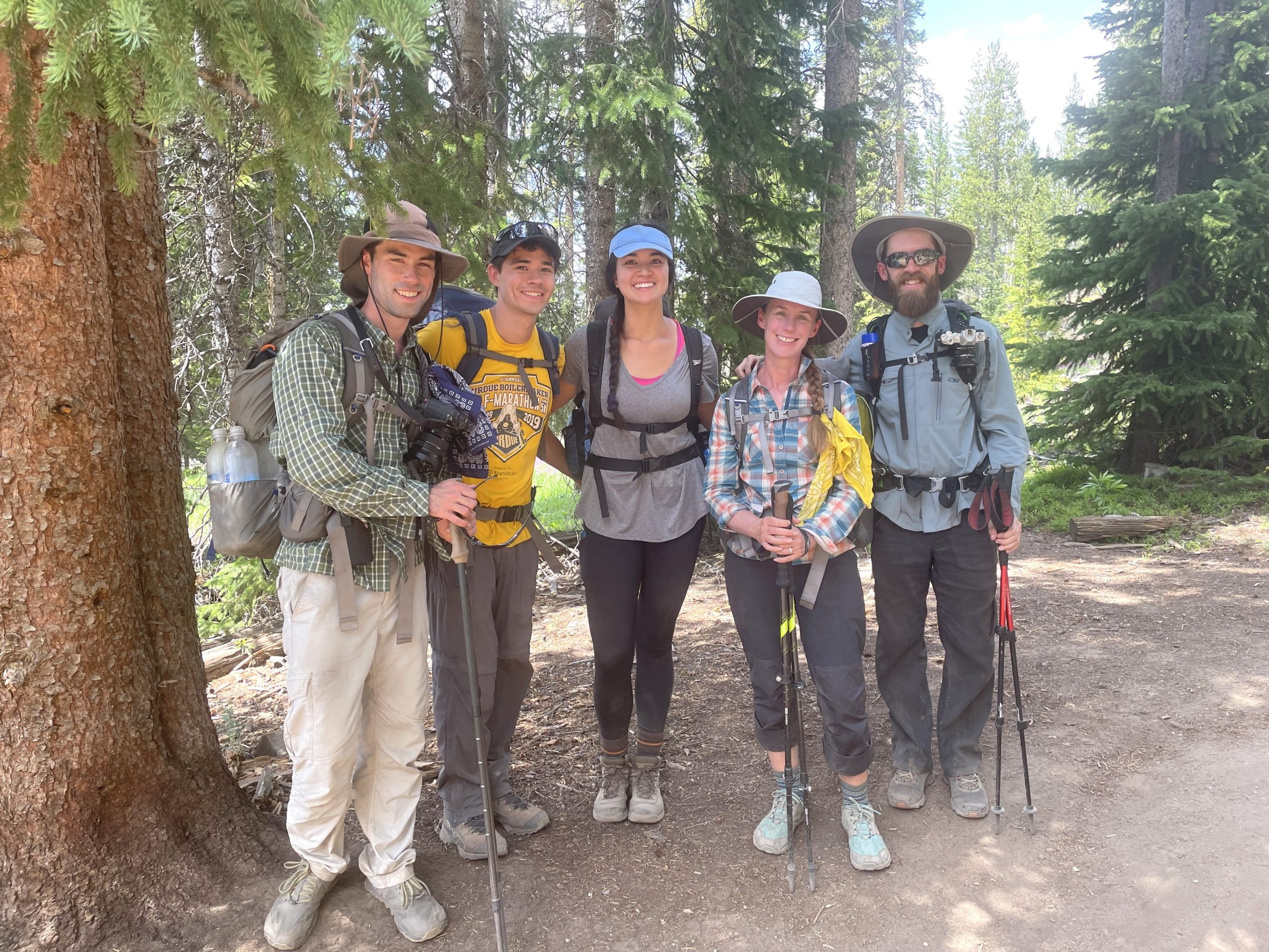
Daniel, Diane, Josh, and I have been meeting up for a summer backpacking trip for several years now. Last summer our plans were thwarted by the Coronavirus pandemic, but now, a year later, we’re all vaccinated and eager to hit the trail again. After some deliberation we decided to visit the Wind River Mountains, a beautiful and rugged range in northwest Wyoming. A few online searches led us to plan a route to the incredible (and therefore very popular) Titcomb Basin. Even with the prospect of crowded campsites, we all agreed that our first trip to “the Winds” might as well include the promise of incredible scenery.
Josh is adventuring around the west coast with his friend Katherine this summer, so Diane, Daniel, and I met them in Salt Lake City. We drove up to Pinedale, Wyoming from there. It’s a bit of a long trip (4 hours) but the scenery along the way is pleasant. We saw lots of antelope and even a few badgers!
Trip Planning
Specs: 37.9 mi | +/- 7100 ft | 3 days, 2 nights
Difficulty: Class 1 with a few sections of bushwhacking around downed trees [learn more]
Location: Bridger National Forest, Wyoming | Home of Crow, Eastern Shoshone, and Cheyenne peoples | View on Map
Route: Begin at the Pole Creek Trailhead and follow the Pole Creek Trail to Photographer’s Point, then on to the Pole Creek Lakes. Continue on the Highline Trail to the Cook Lake Trail, which loops around the lower Cook Lake. Next, follow the Highline Trail northwest over Lester Pass to the junction with Indian Pass Trail at Little Seneca Lake. Take the Indian Pass Trail to Island Lake; from this beautiful spot, you can hike up into Indian Basin or Titcomb Basin. The route back to the trailhead follows Seneca Lake Trail to Eklund Lake where it rejoins the Pole Creek Trail.
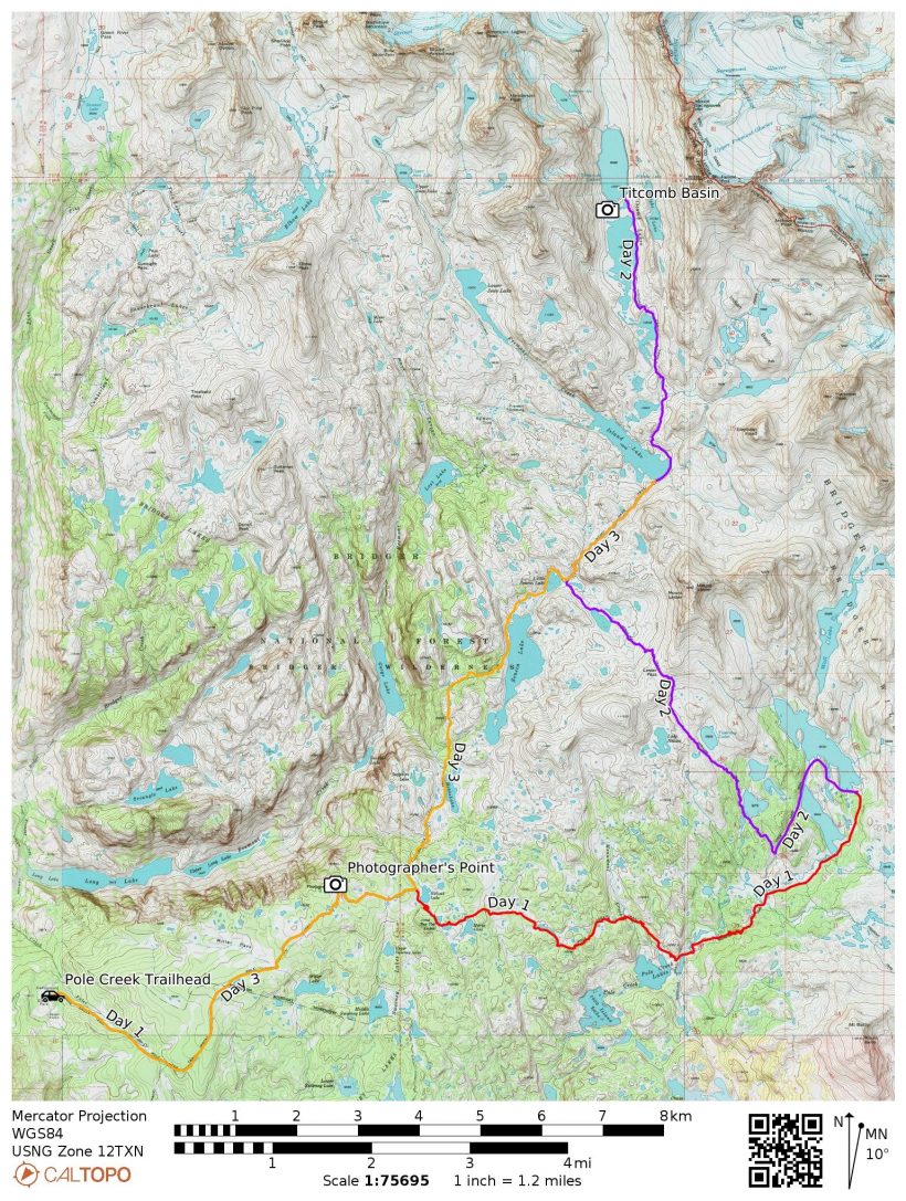
Permits and Regulations: Permits are free, non-quota, and self-issued at the trailhead. Parking is also free the Pole Creek Trailhead! You should follow the usual leave-no-trace ethics, particularly since the trail to and area around Titcomb Basin is highly trafficked.
Resources: The Great Outdoor Shop (in Pinedale, WY) has a great current conditions page for the Wind River Mountains. The USFS website is also a good resource for the Pole Creek Trailhead. I recommend the Beartooth Publishing Wind River Range map for this area; I found the scale on the more detailed maps for the north and south sides of the range to be unnecessarily large.
Elkhart Park to Cook Lakes
17 July, 2021 | 12.3 mi | +2500 / -1600 ft | View on Map
We spent last night camped at Trail’s End Campground, just a few hundred yards from trailhead. I was pretty amazed that we managed to grab a spot on a Friday evening! The sunset was incredible, and the close proximity to the trailhead set us up well for an early start this morning.


We begin hiking at about 7:00, climbing ever-so-gradually through a shaded pine forest. We’re on the lookout for a nearby creek since we’re all a bit low on water. It doesn’t take us long to find a way down to the water, but when we arrive Josh discovers that his Aquamira has leaked, rendering it useless, and Daniel’s Sawyer filter is frustratingly slow. Between the five of us, we manage to filter water for everyone.
Continuing up the trail, we pass through more woods and several long sections of fallen trees. Thankfully, trail crews have cut and cleared the trees from the trail, but the surrounding landscape is littered with them. We guess that they’re probably from the big storm that hit the Winds last labor day. A little further on, the forest opens up to a series of meadows full of lupine and we get our first glimpse of the peaks! About a mile later we reach photographer’s point, a rocky outcropping with a 180-degree panoramic view. We’ve intentionally planned our itinerary with plenty of time for sight-seeing, so we sit for a while, munch on snacks, and admire the mountain vista.


The Pole Creek trail passes lake after lake, many of them unnamed, as we follow it east into the mountains. We wade through the cool waters of Pole Creek in the mid-afternoon and then pause for a little while to watch fish trying to jump through an upstream cascade. Further along the trail, we begin to encounter downed trees lying across the path. Bush-whacking around them proves to be a little tedious, particularly when there are dozens of fallen trees, but we make our way through each section, getting a little closer to the inviting peaks with every moment.


As the afternoon wears on, we slow down a bit. It’s pretty warm out, maybe as hot as 80 degrees. I’m not used to backpacking in that kind of heat. Normally the temperature tops out at about 70 Farenheit up here at 10,000 feet. A few dark clouds drift overhead, threatening an afternoon thunderstorm, but don’t deliver on that threat. We continue on, climbing uphill to the Cook Lakes. I’m excited to pass through alpine meadows after spending most of the day in the forest but I’m also surprisingly tired. We’re on the lookout for campsites as we hike past the lower Cook Lake. There are a few mediocre spots, but nothing very alluring.


About 30 minutes after passing Lower Cook Lake, we crest a hill and descend toward the upper Cook Lake. I’m overjoyed to find several large, sandy flats on the slopes above the lake: perfect campsites! We wearily deposit our gear and set up tents before exploring the area. A lovely sandy beach provides easy access to the lake just below the campsite. I’m hot, sweaty, and ready for a swim, so I jump on in along with Josh, Katherine, and Diane. The water is cold, but not frigid like some mountain lakes. I float out in the water until I feel pleasantly cold and then wade out. Of course, as soon as I and the others are done swimming, the blazing afternoon sun disappears behind some clouds and leaves us shivering.


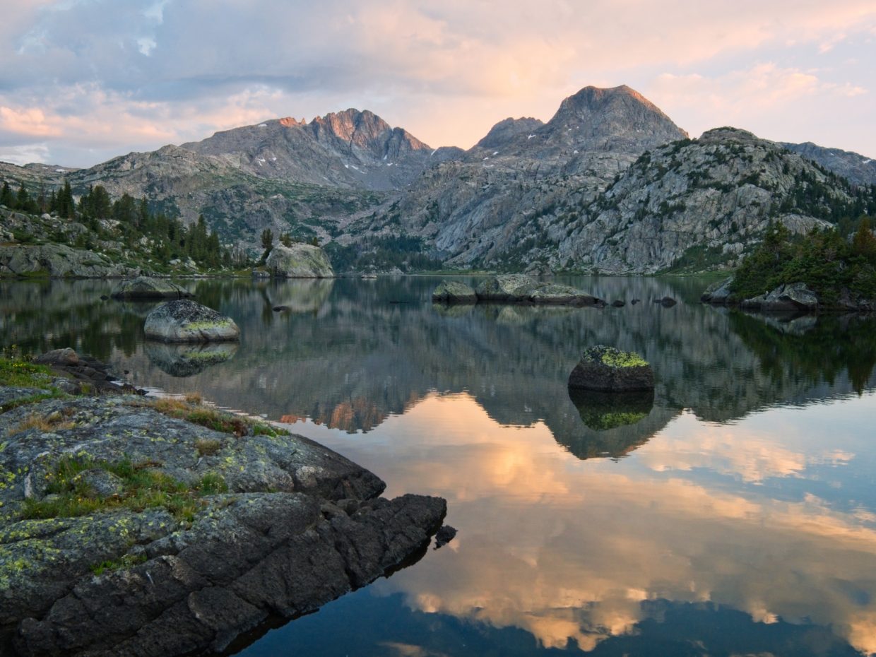
Once we’ve dried off and warmed up a little, we cook dinner and chat while gazing out across the beautiful lake. I’m a little surprised that we’re the only people around, at least as far as we can tell. You don’t really find campsites more beautiful than this… anywhere. After dinner, Josh, Katherine, Diane, and I wander around the lake a bit to a rocky cliff where we get a nice view of the alpenglow on the nearby peaks reflected in the lake.


 and bluebells")
Titcomb Basin
18 July, 2021 | 14.0 mi | +2800 / -2700 ft | View on Map
I woke up well before sunrise this morning, hoping to get a colorful sunrise photo, but the clouds never really “caught fire” like the night before our trip. I think there must be some clouds on the eastern horizon that blocked the light. I still got a little color and some nice shots though, and I enjoyed sitting out by the water for an hour.


The hike this morning begins with a leisurely stroll across a plateau between the two Cook Lakes. We hike along the northern shore of the lower lake and spot several bunches of vibrant red indian paintbrush beside the trail. A little further along, we scramble over some fallen trees and then descend to a junction with the Highline Trail (also the Continental Divide Trail, or CDT).


The next few hours are a little more difficult. It’s already pretty warm out, and the trail climbs steadily toward Lester Pass. Several large, downed trees block the way and force us to bushwhack around them, which just makes the uphill journey that much more tedious. We take several breaks in the shade along the way.


As we approach Lester Pass, the path levels out a bit and we find ourselves wandering through a vast meadow full of wildflowers. In addition to the bright red paintbrush, there are thousands of violet asters and pink elephant’s head protruding from the grass. Every new bend of the trail presents another photo opportunity! After climbing the final, steep bit of trail to 11,100-foot Lester Pass, we take a snack break and gaze out at several large (and unnamed) lakes. We can just make out some of the peaks surrounding Titcomb Basin, our destination for the day.


The descent to the lakes below Lester Pass is hot and dusty with very little shade. We pause for lunch in the shade we can find before beginning the climb up to Island Lake. A train of pack horses and mules trudge by while we eat, schlepping gear into the high country for some paying customers.
The ascent to Island Lake, while hot, is full of wonderful mountain views and thousands of colorful wildflowers. I’m a little nervous about what we’ll find at the lake since this is probably the most famous part of the Wind River Range. We haven’t seen many people though, so hopefully we’ll have some peace and quiet.


When we arrive at Island Lake at about 13:00, the place is mostly empty. We find a nice campsite in the trees and set up our tents. Our plan for the rest of the day is to hike up into Titcomb Basin, but with a minimal amount of gear to make the excursion more pleasant. From what I’ve read, there aren’t many campsites up there. Besides, Island Lake is a spectacular spot to spend the night so we’re not exactly missing out by camping here!
Once everyone is situated, we head out for Titcomb Basin. The trail climbs gently around Island Lake and then levels out as it winds through wildflower-filled meadows, massive stone slabs, and aprons of talus spilling down from the peaks above. Like yesterday afternoon, the sun has hidden behind clouds – I appreciate the slightly cooler weather. Since this is a sight-seeing tour of the basin, we take our time and make many, many stops to photograph the flowers and the lakes. At the highest lake, Josh and Katherine jump in for a swim, but it’s much too cold for the rest of us; Diane, Daniel, and I are satisfied with soaking our feet.
 on their way back toward the trailhead")


After a short break at the highest Titcomb Lake, we turn back toward camp. The sun emerges from the clouds, casting warm light on all those wildflowers and spurring plenty more photo stops along the way. We cook and eat dinner on some large slabs beside one of the lakes and then walk the rest of the way back to Island Lake.


On our way back to camp, we climb up to a cliff overlooking Island Lake. The wind carves interesting wave patterns into the water below and we sit for a while staring out across the water. A few fishermen cast their lines into the water down below us, enjoying the evening in their own way. After a while, we head back to camp. I’m tired and ready for bed, but stay up long enough to watch the sun set.


Titcomb Basin to Elkhart Park
19 July, 2021 | 11.6 mi | +1800 / -2800 ft | View on Map
Today brings another beautiful morning in the mountains, though it’s so warm by 6 AM that I’m comfortably wandering around camp without a jacket – not a good sign for this afternoon. We pack up camp and head out before it gets too hot.


Our return path to the trailhead follows a different route than the first two days of the hike. We stroll past Seneca Lake and then Hobbs Lake, enjoying the shaded woods along their banks. As the sun climbs higher into the sky, the trees lining the trail stop providing shade. By the time we reach the trail to photographer’s point, I’m dripping sweat and ready to jump in another lake. Unfortunately, we have five miles of hiking left to go. The highlight of those hot final miles is a goofy-look group of pack llamas. I can’t imagine they’re comfortable in this heat with their warm woolen coats.


Our first stop after hiking out to the trailhead is Halfmoon Lake. Diane, Daniel, and I will camp there and drive home tomorrow – Josh and Katherine are off to the Tetons later this evening! But before we say goodbye, we all go for a swim, a refreshing end to the long weekend.