Split Mountain is one of the 11 California peaks that is over 14,000 feet tall and it is probably the most difficult of the bunch to get to. The hiking and climb is straightforward, but the 8100 feet of elevation gain is difficult to overcome and the road to the trailhead is very rough, requiring a high-clearance vehicle. Alex and Kim joined me for this weekend adventure and we had a nice time climbing and then relaxing in the mountains!
Trip Planning
Specs: 12.1 mi | +/- 8100 ft | 3 days, 2 nights
Difficulty: Class 2 – 3 [learn more]
Location: Inyo National Forest and Kings Canyon National Park, California | Home of Western Shoshone, Eastern Mono/Monache and Northern Paiute peoples | View on Map
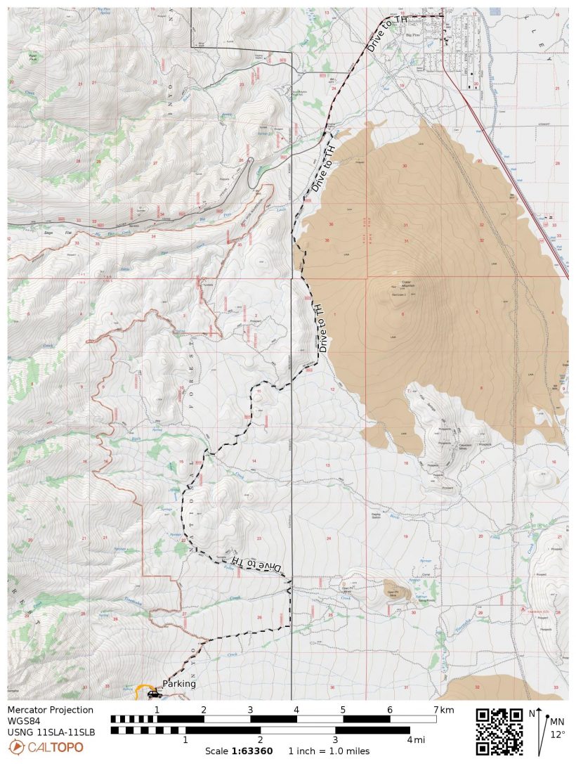
Route: Let’s start with the drive to the trailhead – don’t follow Google Maps since it will route you through private property. Instead, drive to Big Pine, then head west on W Crocker Ave, which quickly turns into Glacier Lodge Road. Make a left turn onto McMurray Meadows Road (dirt), eventually ending up on Tinemaha Creek Road. These roads vary from hard-packed dirt to pot-holed and full of rocks, so make sure your vehicle has plenty of clearance. See the map below for an overview of the road(s).
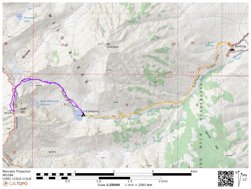
The Red Lake Trail is not particularly well-trafficked, so it can be a bit faint but is generally very easy to follow. This steep path will lead you most of the way to Red Lake; follow the outlet creek up to the lake itself.
From Red Lake, head northwest, generally following the inlet creek up through talus and scree. There are a fair number of cairns and use trails to guide the way. Ascend a steeper section of talus and then continue up a gentler slope parallel to a terminal moraine. Stay to the right of a band of reddish cliffs, climbing up to the obvious notch in the ridge. From the notch, turn south and continue ascending up to the Sierra Crest. The final 50 feet or so are very loose but are easily climbed with the assistance of the solid rock walls on either side; this is the only class 3 part of the climb. Once up on the Sierra Crest, continue south up the broad, talus slope to the summit.
Permits & Regulations: As with all eastern Sierra trailheads, a permit is required for all overnight trips. You’ll also need to store your food properly; I recommend a bear canister. Please remember to follow the Leave No Trace outdoor ethics!
Resources: I recommend the Sequoia and Kings Canyon National Geographic map for trips in this area. The SummitPost page for the North Slope route has good information and some more pictures.
Stormy Afternoon
30 July, 2021 | 3.6 mi | +4200 / -200 ft | View on Map
The drive from LA to Big Pine went smoothly this morning, but the final few miles on the rugged, rock-strewn road are proving to be more troublesome. At first, we speed along hard dirt and gravel with the occasional car-rattling washboard section. But further on we slow to a crawl to navigate around large rocks. The engine overheats from all the extra effort just before we reach the trailhead, so we have to wait for a few minutes until it is cool enough to finish the drive.
The weather forecast predicts rain and thunderstorms every day this weekend and it’s been correct so far. Dark clouds billow around the mountains above us and the White Mountains across the valley are already receiving rain. As I stare out across the Owens Valley I even see lightning strike a few times. Will we be able to make a summit bid or will storms make it too dangerous to venture up there? Should we play it safe and turn back now?
It’s with some nervousness that I begin hiking up the trail with Kim and Alex at 14:30. The wind blows Alex’s hat clean off and nearly takes off with mine before I strap it to my backpack. A few raindrops fall as we walk along the trail above Red Mountain Creek, but they’re not really enough to warrant a rain jacket. A silver lining to this stormy weather is that it’s quite cool, particularly compared to the normal summer 100+ degree temperatures.


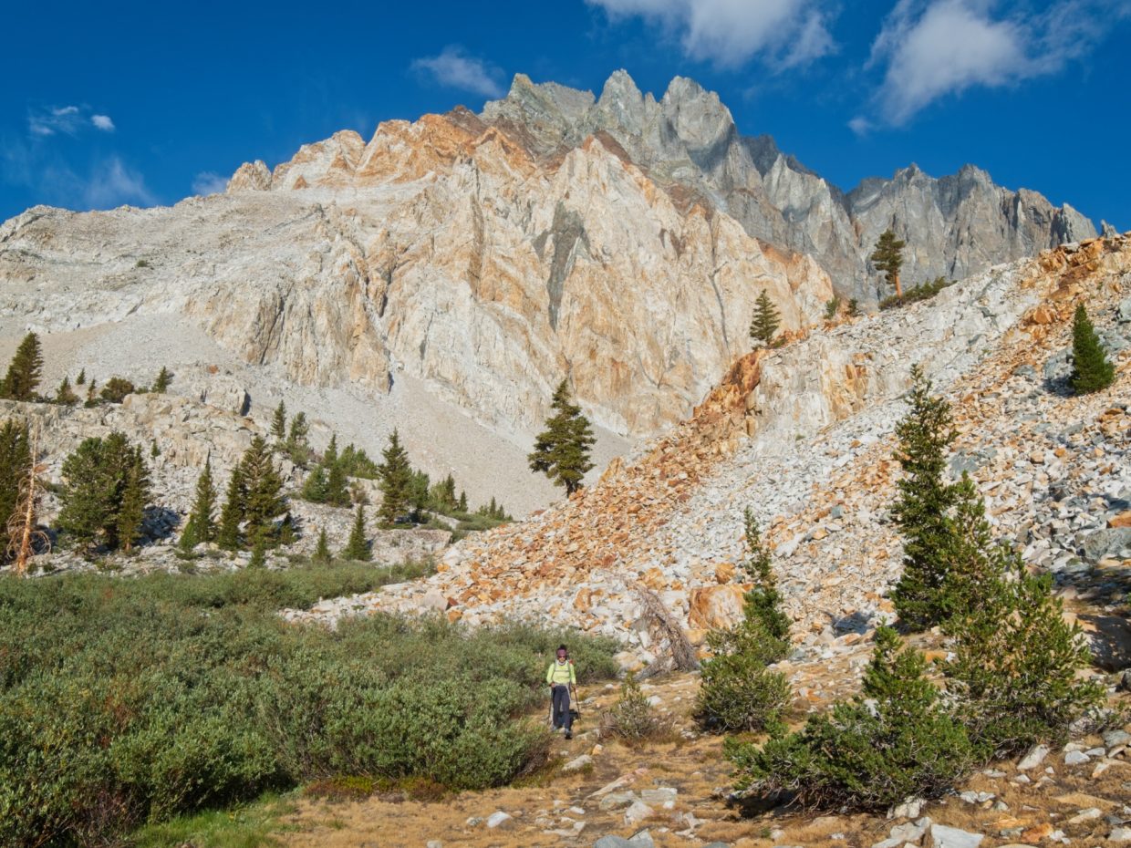
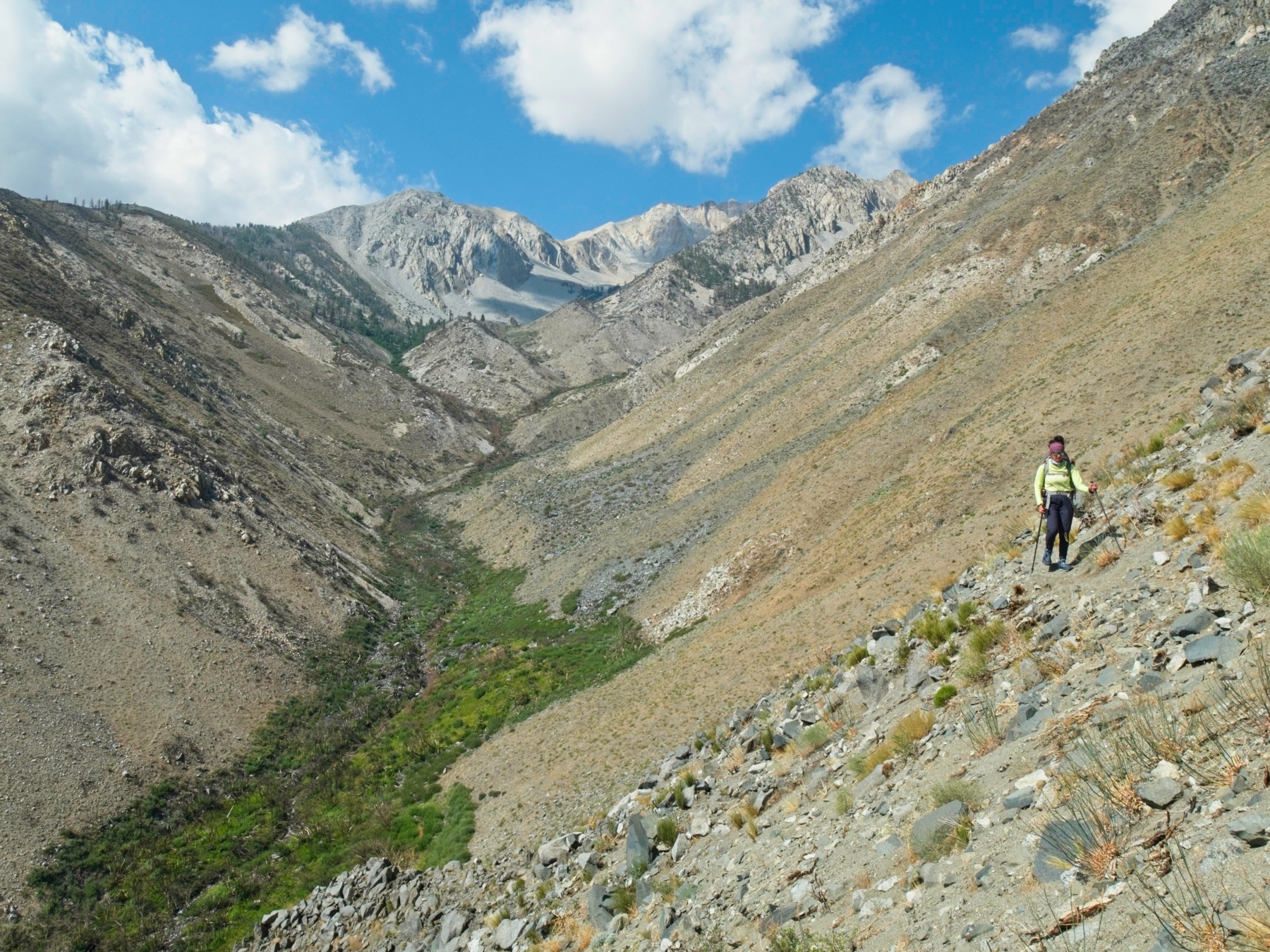
The trail remains fairly level for a while but eventually becomes aggressively steep. I knew it had to at some point; you don’t gain 4200 feet in 3.6 miles without some big uphill climbs. Some trip reports I read claim that the trail is difficult to follow, but I disagree. Only when it crosses a rocky gully do I lose it, and Alex and Kim quickly find the path on the opposite side. We all struggle up the steep and loose switchbacks and agree that this is certainly one of the steepest trails we’ve ever hiked.
A bit further up the trail we pass through a lush oasis. The trail follows a creekbed for a few hundred feet and we have to duck to avoid the low-hanging branches. Once we emerge from the tiny jungle we follow the trail through some majestic whitebark pines. Sunshine comes and goes as the clouds writhe overhead, but the absence of storms and rain so far brightens my mood a bit; maybe this trip will work out after all!


Kim, Alex, and I arrive at Red Lake at 18:30, four hours after leaving the trailhead. To be honest, that’s a little faster than I expected we’d be, particularly since the trail is so steep and we’re carrying backpacks full of overnight gear. Regardless, I’m very tired and very hungry, so I don’t waste any time setting up camp and preparing dinner.


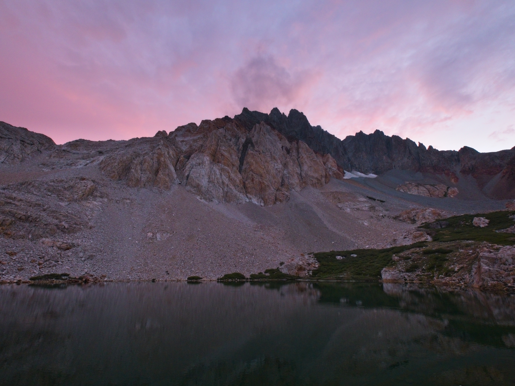
After eating, we relax on the lake shore and play a few card games while watching the clouds come and go. I’m in awe of the view of Split Mountain from Red Lake. The colorful, serrated ridge is unlike any other mountain I’ve seen and it towers almost 3400 feet directly above the lake. The sunset turns out spectacularly, another perk of venturing into the mountains during stormy weather! We all head to bed pretty soon after dark: we’ll be starting our summit bid tomorrow long before dawn so that we have enough time to avoid the forecast storms.
Climbing Split Mountain
31 July, 2021 | 4.9 mi | +/- 3700 ft | View on Map
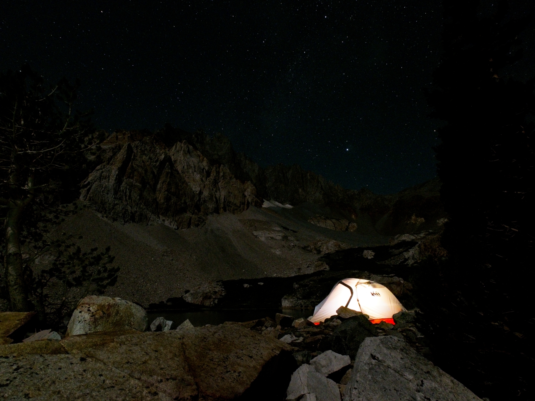
My alarm wakes me up at 3:30. I’m up a little earlier than necessary because I want to take a few photos of the night sky. I’m excited to find that I can see the stars since that means the skies are no longer overcast! A nearly full moon illuminates the landscape too and enables some pretty great pictures with the stars, the mountains, and Kim’s glowing tent.
We begin the climb to Split Mountain at 4:45, lighting the way with headlamps. The first section of the route wanders through the willows above Red Lake and then up a class 1 talus slope where cairns guide the way. The cairns are hardly needed, however, since the route up the slope is very straightforward. By the time we reach the terminal moraine at the top of the slope, it’s light enough to see without the headlamps.


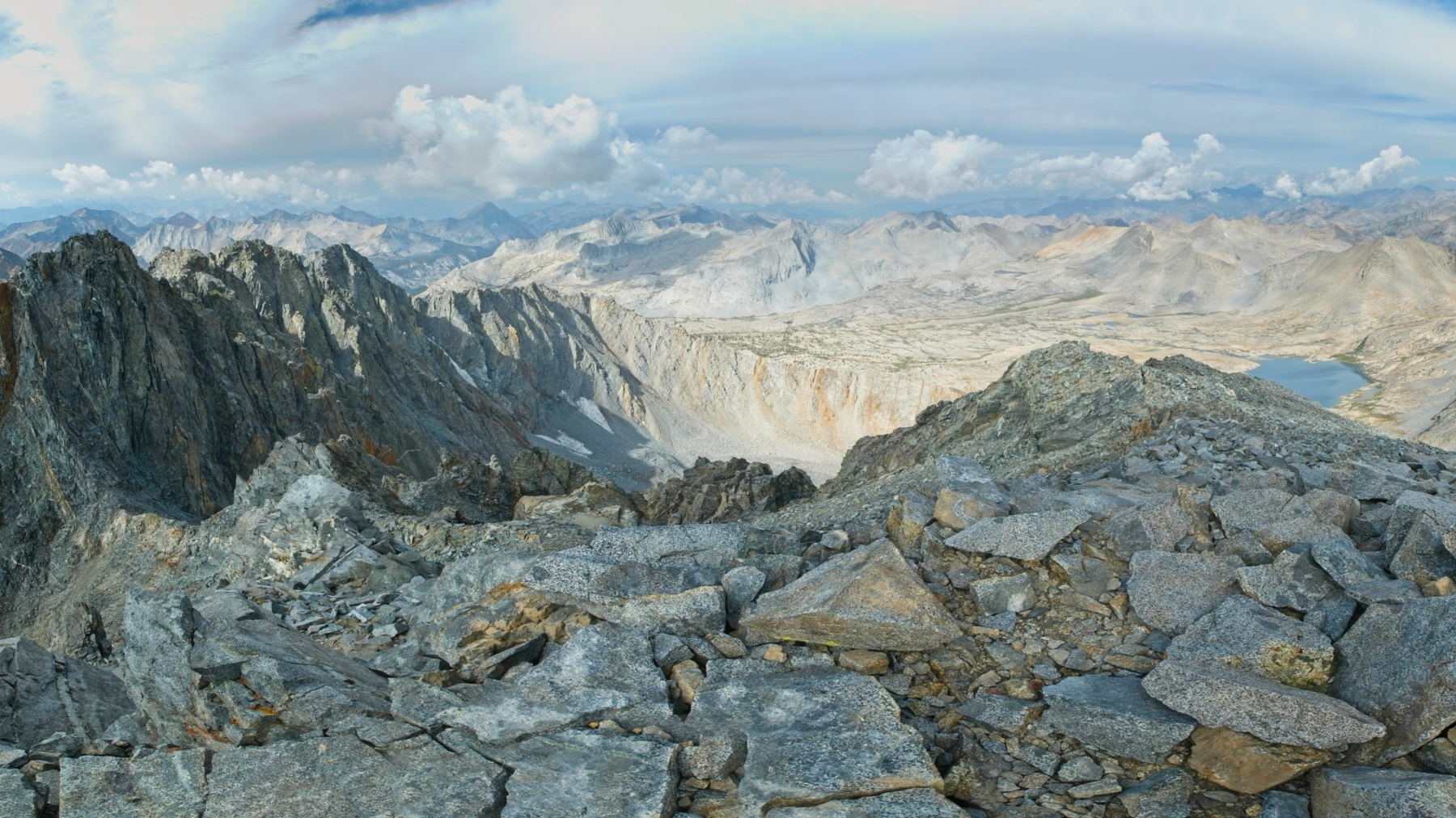
The next section of the climb requires a lot of rock hopping, pretty standard class 2 terrain. We continue up the slope, making for a small notch in the ridge to the right of some red, protruding cliff bands. It’s a long climb, but very straightforward. The views from the ridge surprise me. I expected to look down into Upper Basin, an enormous valley on the other side of the Sierra crest. Instead, the ridge drops precipitously beyond the notch into a deep chute. Our route is clearly not down there!


After reviewing the route description, I realize that we need to turn left (south) and continue up the ridge for several hundred more feet to the Sierra crest. So we begin climbing again, now through looser scree. A short, steep, and loose chute at the top of the ridge is the crux of the climb but we scramble through it without any trouble by holding onto the rocks that line the chute.


The final section of the climb is easy class 1 – 2 climbing through scree and talus, but the 13000+ foot altitude makes every step a struggle. I only manage spurts of 10 or 20 feet between pauses to catch my breath. Kim and Alex struggle along with me, but we all make it to the summit by 9:30! We’ve all been keeping an eye on the clouds to make sure we don’t get caught in bad weather and they’ve cooperated so far. A few fluffy cumulus clouds drift through the sky, but they’re all small and unlikely to develop into full-fledged storms any time soon. So we relax on the summit for a little while, signing the summit register and taking photos.


We begin the descent a little before 10 AM and make much better time descending the expansive north face of Split Mountain than we did ascending. When I look back at the summit from the bottom of the slope, I’m surprised to see completely overcast skies. I’m still skeptical that it will rain, but I pick up the pace a little bit just in case. As we continue to descend, the clouds enshroud the peak; even if it isn’t raining, I’m glad we got up there early enough to avoid the white out!
Like most cross-country mountain climbs, descending from Split Mountain isn’t particularly difficult but it is tedious and requires constant attention to foot placement. We return to camp at about 13:15, tired but pleased to cross a new California 14er off the to-do list.


Although we have plenty of time to hike out, we decided ahead of time that we would stay an extra night and enjoy a relaxing afternoon at Red Lake. I take a nap in my tent and Kim finds a nice flat rock to sleep on. Later in the afternoon, we sit and chat while Alex busts out a lightweight watercolor kit and paints Red Lake and Split Mountain. The clouds stick around for most of the afternoon, but never drop any precipitation on us. We play some more card games in the evening and eventually go to bed.
Morning Descent
30 July, 2021 | 3.6 mi | +200 / -4200 ft | View on Map

The morning once again brings blue skies and plenty of sunshine! Several day hikers pass through camp on their way to the summit while we’re packing up. Kudos to them — hiking all the way up and down Split Mountain in one day is sure to be a difficult trip.


I snap a bunch of pictures on the way out of camp. Split Mountain towers over the landscape and its colors are incredible in the warm morning light! I enjoy the descent at first, but the temperature becomes increasingly hot as we lose altitude and the sun climbs higher into the sky. The charred plants and barren landscape only add to the stifling heat. Thankfully we’re descending in this weather rather than ascending. I feel sorry for a backpacker we pass further down the canyon; he has a long, hot slog ahead of him.


When we reach the trailhead, the car thermometer reads 90 degrees and it doesn’t get any lower as we rumble down the rocky road. The drive back is a bit of a struggle; we have to rearrange some rocks on the road to clear a particularly deep trough. After at least an hour, we make it back to pavement and speed off in search of Mexican food and ice cream.
Craig Barlow 27 August 2021
Nice report. Red Lake is a really great spot and you got some awesome pics, especially at sunset!
Andrew 28 August 2021 — Post Author
Thanks! The hike in was so short on this one that I packed the tripod.
Jason Bax 14 January 2022
Great blog you’ve got here! I’ll have to put this on my list for next summer. While on the SHR I spent a wild evening on the big bench just West of Frozen Lake Pass, watching a massive storm build for hours above Split Mountain across the valley to the East. Cheers, Andrew!
Andrew 24 January 2022 — Post Author
Thanks Jason! I do highly recommend this hike – it was really beautiful. P.S., your photography is amazing!
Tony 20 February 2022
Thanks for the report, will go this June, hope not too much snow
Alec Hopkins Ferguson 14 July 2025
Excellent post, thanks for the helpful beta. Climbed in a day on Saturday. Super cool zone and pretty fun climbing. Spectacular summit, wildflowers galore, cool trees. 4×4 road to the trailhead was doable in a Tacoma. I doubt a lower clearance vehicle could make it — maybe an Outback?