I joined Erica and Alix for some ski mountaineering this weekend in the Kearsarge Pass area. We met Maddy and Roland, who already spent a day skiing, on Friday evening for a Saturday objective of Mount Gould. Unfortunately, they were pretty wiped from their adventure and ended up staying behind on Saturday.
Trip Planning
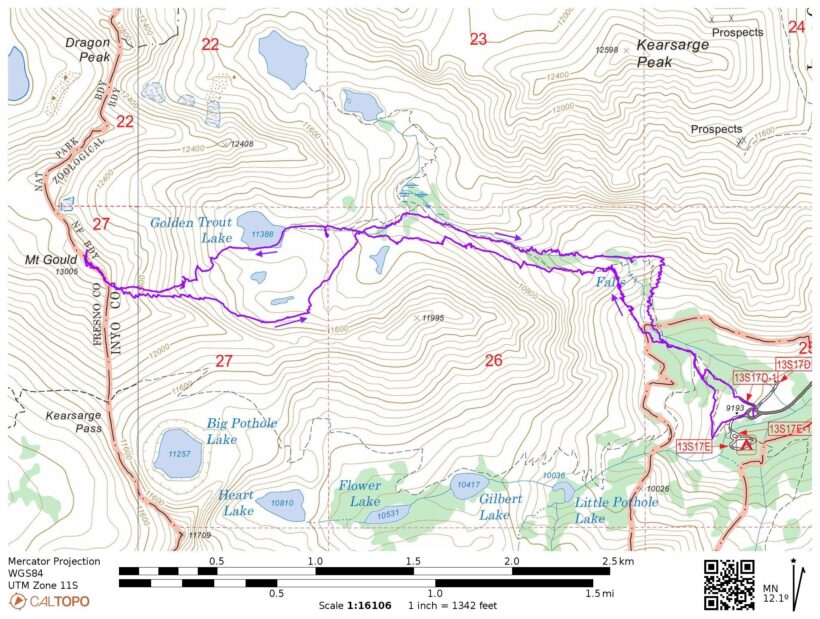
Specs: 7.4 mi | +/- 3900 ft
Difficulty: Class 1 approach and climb to ridge with a few class 3 – 4 moves to reach summit [learn more]
Location: Inyo National Forest, California | Home of Eastern Mono/Monache and Western Shoshone peoples | View on Map
Route: Begin at the Kearsarge Pass trailhead and follow the trail toward Golden Trout Lake. Stay right (north) of the waterfall and follow the canyon, i.e., the same route as the summer trail. (We ascended a talus shoot south of the waterfall and stayed above the canyon; while we didn’t encounter any technical difficulty, the canyon route is certainly easier.)
Permits & Regulations: No permits are required for day hikes in this area, and parking is free. Wilderness regulations do apply and, as always, make sure you leave no trace!
Resources: The Kearsarge Pass Trail page is a great resource for trip planning. We referenced Greenberg and Mingori’s Backcountry Skiing California’s Eastern Sierra for route guidance.
Route-Finding is Best in the Dark
Saturday, 17 June, 2023 | 7/4 mi | +/- 3900 ft | View on Map
Our alarms go off this morning at 1 AM. I groan – it’s only been three hours since I went to bed – but dutifully get up and start packing my things. Erica, Alix, and I leave our site at Upper Grays Meadow Campground a little before 2 AM and drive up to the Kearsarge Pass Trailhead. After a (futile) bathroom break, we shoulder our packs with skis and boots attached and begin walking up the trail in our lightweight hiking shoes at 2:45.
We soon reach snow and are faced with a decision. Do we continue following the summer trail route, which crosses the creek twice, or do we hike up a comparably steep slope and avoid the creek crossing altogether? In the pitch black (there’s a new moon this weekend) it’s difficult to compare the options. We can hear the creek roaring through the rocks and can tell that it’s covered by snow but how much snow? Falling through a snow bridge into icy water is a dangerous option so we decide to make our own way up the slope and avoid the creek crossings. (In retrospect, there was plenty of snow to make the bridges stable and following the summer route would have been a significantly easier path for us.)
We cross a snowfield and then begin scrambling up semi-stable talus. It’s not particularly easy – the slope is pretty steep and it is talus – but not too terrible either. We reference the topographic map constantly and try to avoid the steepest slope angles as we wind up a narrowing chute. Thankfully we don’t run into any cliff bands and emerge onto the ridgetop without any technical difficulties.
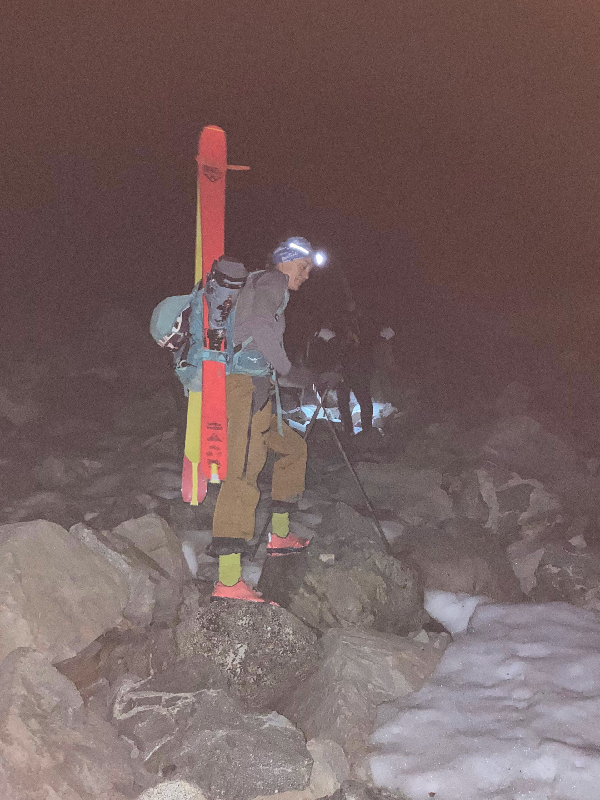
Atop the ridge we’re able to follow the summertime trail on dry ground for a while. However, snow banks eventually encroach on the path. We follow a set of boot prints for quite a while, taking advantage of the existing indentations to secure our hiking shoes on the otherwise icy slopes. After a while we’re forced into ski boots and crampons by a slope that’s just too steep to comfortably trust the boot track; a slip and fall would be dangerous.
Now with the freedom to cross the ice any way we like (and daylight to see where we’re going!), we abandon the track and head more directly uphill toward Golden Trout Lake. We stop along the way for a bathroom break in some trees and transition to skins when it becomes clear that the snow cover is continuous.


We reach warm sunshine at Golden Trout Lake around 6:30. Mount Gould looms directly across the lake with several snowy chutes leading up to the summit. They all look passable but we stick with the guidebook’s suggestion to ascend the southern-most chutes. We skin on up, slipping occasionally as the top layer of snow softens. By the time we reach 12,000 feet the sun has softened the snow so much that the skis and skins are more of a hassle than a help – they keep slipping! Even ski crampons don’t help in the soft, slushy surface layer. So we take a break on some protruding rocks and transition back to boots and crampons.


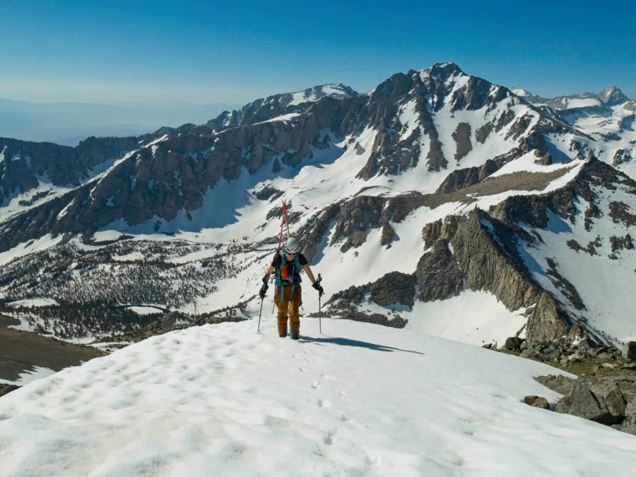
Climbing the next 800 feet to the south ridge of Gould Peak feels like the hardest part of the day to me. It’s simple enough – kick steps and walk up the steep slope – but the effort is exhausting. Alix, Erica, and I alternate leading the way, letting the followers take advantage of the pre-kicked steps for as long as we can manage. At least the views along the way are great! University Peak dominates the landscape to the south and the snow-covered Kearsarge lakes and pinnacles fill the western view.
After much effort we reach the summit ridge and the end of the snow at about 8:45. Conditions are just right for skiing but we take a quick detour to tag the summit sans ski boots and backpacks. We scramble up a false summit first; Alix and Erica are content to stay there but I hurry over to the true summit so that I can officially check this peak off my list. Reaching the very top requires a few class 4 moves with a little exposure but I find it really fun!


By 9:50 we’re back in skis and on our way down the mountain. Unfortunately, it seems like the snow has softened a bit too much during our rest and detour to the summit. The top layer of snow slides under its own weight as we turn down the steepest slopes just below the ridge. Conditions are a little better lower down, however, and we enjoy some turns on the shallower slopes.
We follow a different way down than our ascent route. Rather than descending directly to Golden Trout Lake, we traverse southeast across the ridge to avoid loosing too much altitude and then drop down through scattered rocks and small trees to the canyon below the lake that we avoided this morning. A group of ascending hikers tell Alix that they’ve hiked all the way up the canyon and had no problems with snow bridges, so we continue down confidently, enjoying the skiing.


To our surprise, we find Maddy and Roland at the bottom of the canyon when we arrive at 10:45. They’ve hiked some soda and beer up to share with us! We all sit in the shade of tall pines and relax and talk. We eventually head down the final few hundred feet of the mountain, skiing as far as we possibly can into the debris-covered snow in the forest. From there it’s an easy 15-minute walk back to the trailhead and cleaner clothes.

james cox 19 July 2023
A lot of different experinces. Neat