I’ve been meaning to climb Mount Shasta for years. In 2021, my friends and I were turned away by unpleasant summer conditions (little snow, lots of loose scree) and in 2022 we were turned around by 60 mph winds and up to a foot of fresh snow. But this year there’s plenty of snow and we lucked into a beautiful weather window! Jack (check out his website!), Josh, and I met up in Sacramento and carpooled up to the Bunny Flat trailhead together. A variety of routes begin from this trailhead: Avalanche Gulch, Casaval Ridge, and Green Butte Ridge, among others. Although Jack and Josh had aspirations to climb a technical route I was more in the mood for a non-technical trip up Avalanche Gulch, particularly since this is only my second ski tour and my first real high-altitude trip of the season. I convinced them to take the “easy” route in the end.
Trip Planning
Specs: 12.8 mi | +/- 7300 ft | 2 days, 2 nights
Difficulty: Class 1 [learn more]
Location: Shasta National Forest, California | Home of Modoc, Winnimem Wintu, Northern Wintu, Siletz, Shasta, Pit River, Cayuse, Umatilla, and Walla Walla peoples | View on Map
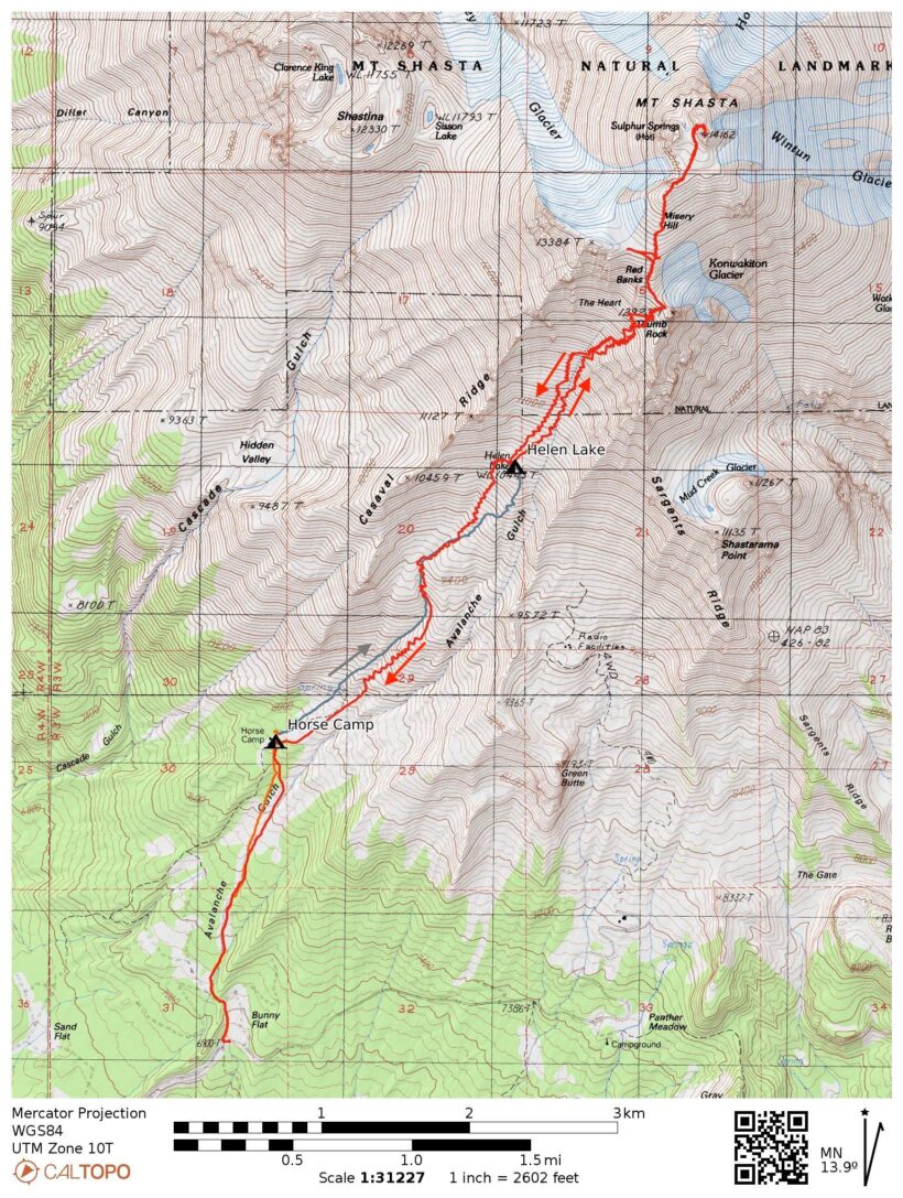
Route: Begin at Bunny Flat and follow the well-worn boot track to Horse Camp. Continue up Avalanche Gulch to the top of the Red Banks, staying to climbers’ right of The Heart and left of the The Thumb. Traverse across the ridge above the Red Banks and climb toward and over Misery Hill. The summit is reached from looker’s left via a moderate slope.
Permits & Regulations: A wilderness and summit permit is required for trips above 10,000 feet on Mount Shasta. You can pick one up from the ranger station in town or self-issue the permit at the Bunny Flat trailhead; the cost is $25 per person. Due to the snowy conditions most of the year you’ll need to pack out your poop; wag bags are available at the trailhead and at the ranger station. Finally, remember to leave no trace (as always)!
Resources: The ShastaAvalanche.org website is a fantastic resource for avalanche forecasts, current conditions, and trip reports. The Tom Harrison map provides a great overview of the area. On the mountain, Horse Camp offers a composting toilet and running spring (check online for current status). The camp is donation-supported, so bring a little cash along (the suggested donation for overnight use is $5).
Horse Camp
19 May 2023 | 1.5 mi | + 1000 ft | View on Map
I pick Josh and Jack up from the Sacramento airport on a sunny Friday afternoon. It’s a scorching 95 degrees outside, much too hot for May! We squeeze their gear into my car and hit the road, stopping for lunch and then groceries on the way up to the town of Mount Shasta. We make a brief pit stop there to refill the gas and buy summit permits from the ranger station and then drive straight to the Bunny Flat trailhead.
Parked cars line the road near the trailhead but we drive all the way up and happily find plenty of empty parking spaces. Josh and Jack explode their suitcases and pack up their bags for the trip while I change from comfortable driving clothes into hiking attire. It’s a little cooler up here at 6900 feet but the car thermometer still reads 85 degrees. I smear some sunscreen onto my face and hands and don a cool bucket hat to try to keep the bright sun off. I’m in long pants and a long sleeved sun shirt – not the coolest clothes for a hike in these conditions, but if past mountaineering trips have taught me anything its that the only sure way to avoid a painful sunburn is to cover your skin.
We set off from the trailhead at about 16:45, Josh and I on skis and Jack on foot. Thankfully, a well-traveled boot track provides solid footing free of post-holing and we maintain similar speeds. Our goal for tonight is to reach Horse Camp, a permanent campsite with some nice amenities like a composting toilet and a flowing spring. We cover about 1.4 miles and gain a thousand feet over the course of the next hour, arriving at the campsite at 17:30. I make frequent use of my bandana sweat rag during the hot climb but cool off quickly once we stop moving.
We’re hardly alone at Horse Camp; there must be at least 20 or 30 tents scattered through the woods around the mostly-buried cabin shelter. We find a flat-ish spot nearby and begin the process of constructing a campsite. I stomp out a tent platform and then put up my tent, digging a “boot box” at the door so that I can step in and out of my ski boots. We also dig a bench where the three of us can sit comfortably and cook dinner.


Once we’ve set up camp we walk over to a sunny spot (it’s cold in the shade!) and discuss our plan for tomorrow. We have two options: we can either make a bid for the summit or we can hike a few more miles up to Helen Lake and then make our summit bid on Sunday. At first I’m very much in favor of the former. Spending an entire afternoon laying around doesn’t sound very appealing and I think we could make it to the summit if we got an alpine start at 2 or 3 AM. But we’re all pretty tired after traveling all day and that level of effort sounds unpleasant too. We eventually decide to have an easy day tomorrow. It will be nice to have an extra day to acclimate to the altitude and we have plenty of time; summitting tomorrow would just mean we have an entire day on Sunday to fill.
With a plan in place we sit down for dinner. Jack and Josh cook up dehydrated meals while I finish off a sandwich I bought earlier. I retire to my sleeping bag around 8 PM to escape the increasingly chilly air and spend some time reading and browsing social media (the cell service is surprisingly good). Once the sun sets I drift off to sleep.
High Camp: Helen Lake
20 May 2023 | 1.8 mi | +2500 ft | View on Map
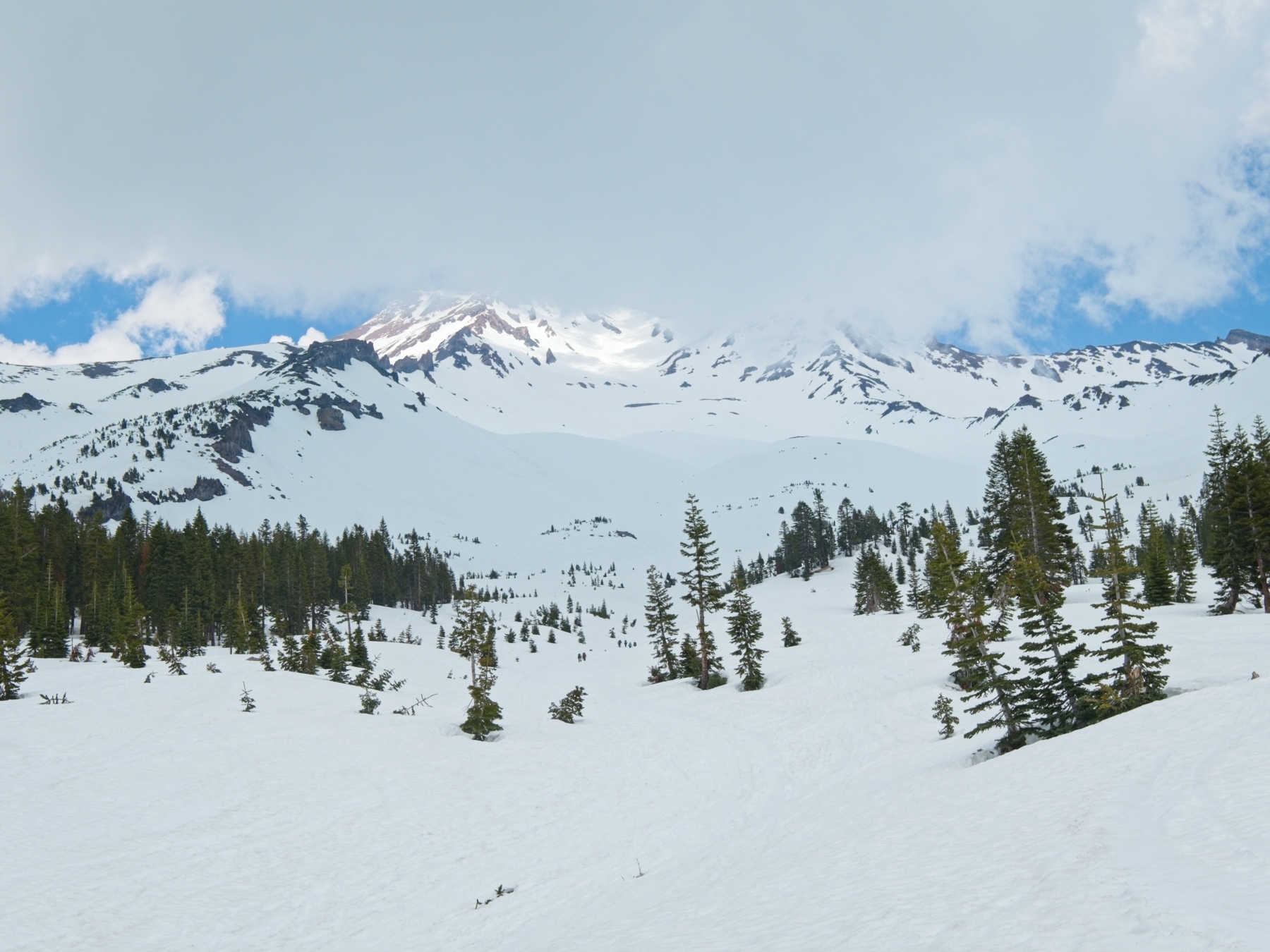
I stay in my tent until the sun rises this morning, emerging around 7 AM. We’re in no hurry so we enjoy a leisurely breakfast. Looking up at Mount Shasta we can see dozens, maybe even hundreds of ant-sized climbers on the upper slopes of Avalanche Gulch. I’m a little surprised at the number of people but Josh isn’t. He guided people up Mount Rainier for several months last season and he’s grown to expect huge crowds on the weekends.


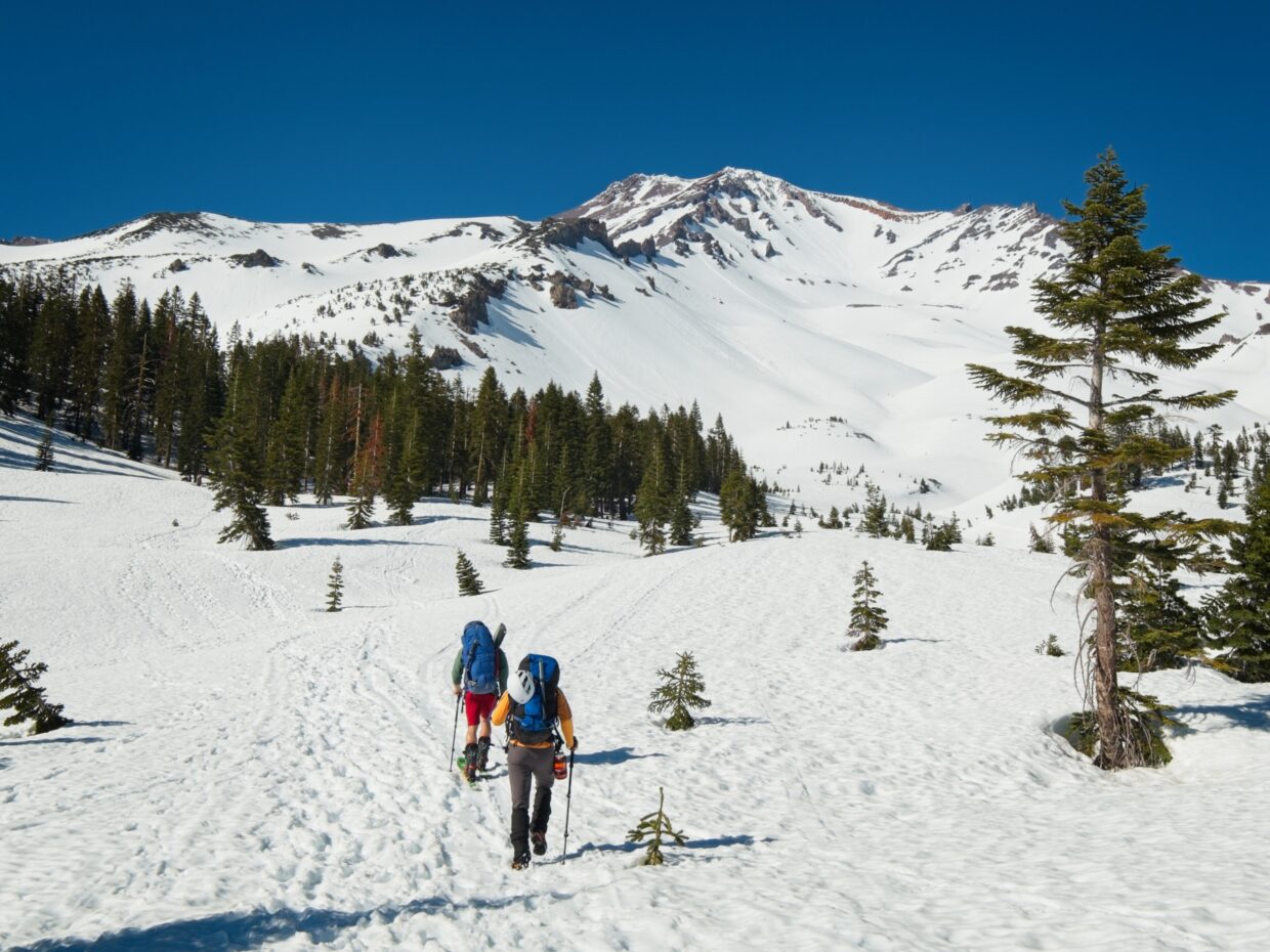
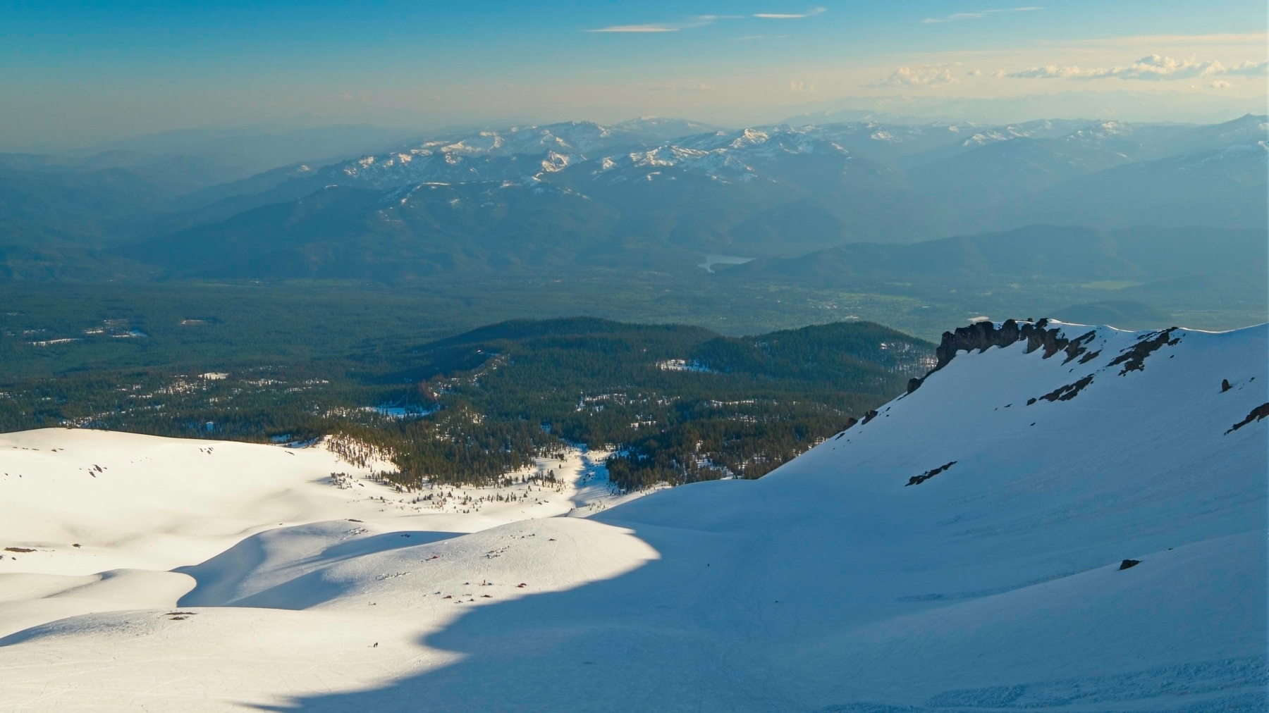
We beginning skinning and hiking up toward Helen Lake at about 08:50. It’s another bright, sunny day, but it feels cooler right now and I’m much more comfortable than last night. We settle into a steady pace and work our way up the gulch, sticking to the lowest slope path. We pass quite a few hikers, skiers, and split-boarders on the way, all likely headed to Helen Lake like us.


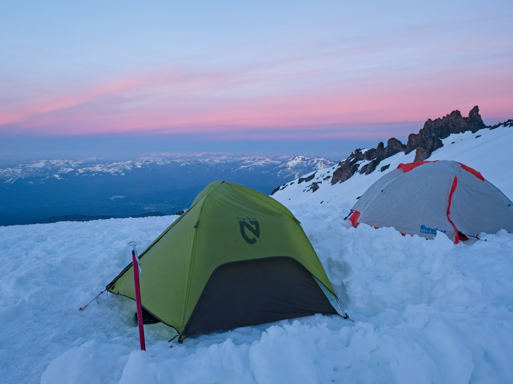
About 2 hours later we arrive at Helen Lake, or where Helen Lake is supposed to be. Everything is covered with snow and there’s no sign of any lake. We’ve made excellent time, gaining 2500 ft and covering 1.8 miles. We’re all feeling much more energetic than yesterday, which bodes well for our summit bid tomorrow! A few dozen tents litter the snowy plain and we make our way over to an area with a great view of the mountain below. If we’re going to hang out all afternoon we might as well have a good view! I’m eager to set up camp but we realize that the smart move is to wait for people to vacate the pre-leveled and walled tent sites. So we park our butts on our skis/packs for an hour or two until climbers returning from the summit have packed up and left.
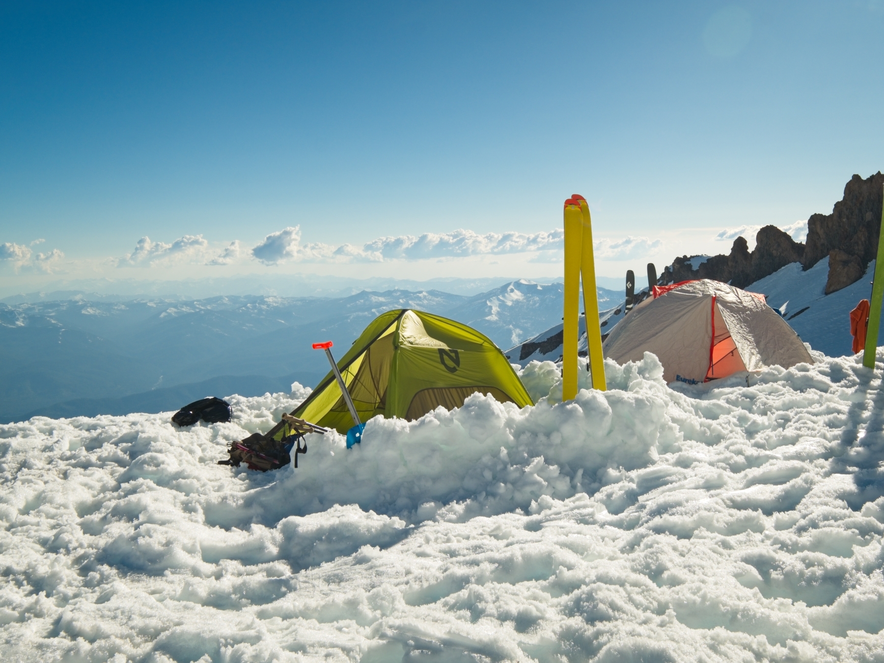
Once I’ve got my tent up I escape into the shade it provides; Josh and Jack do the same. I leave the doors open so that the cool breeze can blow through and I change into a short-sleeved shirt. I spend the next several hours reading, writing, and staring out the door. Despite my misgivings yesterday, I actually really enjoy the relaxation (though I’m not sure how tolerable it would have been without a book).
I get up around 17:00 to melt snow and refill my nearly-empty water bottles. It’s not a very fast process but hey, I’ve got all the time in the world. Josh, Jack, and I reconvene at 18:00 to cook and eat dinner together. We joke and talk for a few hours while watching the shadow of the mountain drift further and further across the landscape.


There’s a slight chance of rain and thunderstorms tonight and a few ominous clouds appear around 7 PM. We keep an eye on them but they never make it over our camp and seem to break up when they hit Casaval Ridge. We hang out until the sun has mostly set and then call it a night. We’ll be up early tomorrow!
Mount Shasta Summit
21 May 2023 | 9.5 mi | +3700 / -7300 ft | View on Map
I wake up at 3:00 to some very noisy neighbors preparing for their climb. I’m a tad annoyed but I have to pee anyway, so I take the opportunity to get up and relieve myself. I’m amazed to see a long line of glowing headlamps stretching all the way to the top of Avalanche Gulch. Who in their right mind is already up there at 3 AM? They’ll be off the mountain by 9:00!
I go back to sleep for another 90 minutes and then get up, eat breakfast, and finish packing my bag. Our plan is to begin hiking at 5:30. We figure it’ll take us about 3 hours to reach the top of the Red Banks (a vertical gain of about 2400 feet over 1.6 miles) and then another 1 – 2 hours to the summit (another 1400 ft of gain and 1 mile). We should be able to descend back to the top of the Red Banks in an hour, bringing the time to around 11:30. Other skiers and climbers have told us that the snow softens up around that time, making conditions perfect for skiing and glissading!
In contrast to the past few days, we’re all on foot this morning. Josh and I don’t have ski crampons and the slope above Helen Lake is too steep and icy for skinning to be a very comfortable travel method. So crampons and boots it is! Josh and I are carrying our skis, of course – I can’t wait to ski down the entirety of Avalanche Gulch! We leave our avalanche gear (beacon, probe, shovel) behind since the past few days have had zero avalanche activity and the risk should be even lower today due to lower temperatures and more cloud cover.


This morning is my first time hiking in ski boots with crampons. I quickly realize that pointing my feet forward (i.e., up the slope) is incredibly uncomfortable. The ski boots just don’t flex enough at the ankle. I can front-point the crampons into the slope and keep my heels a few inches off the ground but I much prefer side-stepping up the hill. The crunchy snow is easily firm enough to hold the crampons and I zig-zag to alternate muscle groups. Josh and Jack are both faster than me but I’m never more than a few minutes behind.


We take a few breaks on the way to the Red Banks. The sun hasn’t made it over the ridge yet though, so it’s too cold to be comfortable sitting still for very long. I prefer to keep moving at a slow but manageable pace. By the time we reach the ridge above the Red Banks we’re 30 minutes ahead of schedule and we take a few minutes to sit in the warm sun. For the first time all weekend we see dry trail ahead. Red scree patches break up the snow cover on the ridge and the dark scree slopes of “Misery Hill” rise in the distance.


After a rest we continue along the ridge. We’ve already gained 2400 feet so we only have about 1400 to go! I appreciate the briefly level walk; it gives my aching feet and butt a break from the uphill side-stepping. We all keep our crampons attached, scraping through the rocks between the icy snow patches. When we reach the base of Misery Hill Josh and I stash our skis. We won’t be skiing down that scree slope, after all!


I really struggle with the ascent up Misery Hill – the altitude is taking its toll. Hike a switchback, stop to breathe, hike another switchback, stop to breathe… Josh and Jack wait patiently for me atop the ridge where we take another rest on the leeward side of some large rocks. Out of the brisk wind it’s actually quite comfortable! The summit block looms across a snowy plateau; a line of climbers work their way up a slope to the rime ice-frosted pinnacles.


We soon set off across the football field-sized plateau. By the time we reach the slope that leads to the summit the line has disappeared and we have plenty of space to navigate the mixed snow and rock. The summit itself is dry and I stumble a few times as my crampons snag on the rocks. We each pose for a photo on the summit and then huddle into a sheltered spot slightly below to eat some snacks and enjoy the accomplishment!


Descending from the summit takes much less time than the ascent. Both of Josh’s crampons fail on the way (rivets falling out) but luckily the snow has softened up enough to plunge-step down the steeper slopes. We reach the foot of Misery Hill by 11:00 and split up. Jack retraces our ascent route to glissade down Avalanche Gulch and Josh and I ski over to the skier’s-right side of the Red Banks. Others have told us this is the best place to drop in for skiing; it gets sun early and will be soft, and the slope is very reasonable.
A small crowd of skiers are all relaxing on the snow above the gulch when we arrive. Josh isn’t very excited about the slope and neither of us are happy about the icy conditions so we backtrack to the top of the Red Banks. We put on our skis just below the rocks and begin skiing! The snow is icy at first, but manageable. We make a few turns down the skier’s-left side of the gulch and then make our way over to the right. The sun has been warming that snow longer and it’s much softer. We seem to have missed the corn snow but I still really enjoy skiing through the thin slush.
About halfway down the bowl I spot a ski-path through the minefield of avalanche debris and lead the way through to a wide expanse of softer and more enjoyable snow. I enjoy a few thousand feet of smooth turns through the wet snow and arrive back at camp feeling elated. Josh arrives a few minutes later, but Jack beat us both down! The glissading soaked his lower layers through so he’s drying off in the tent.
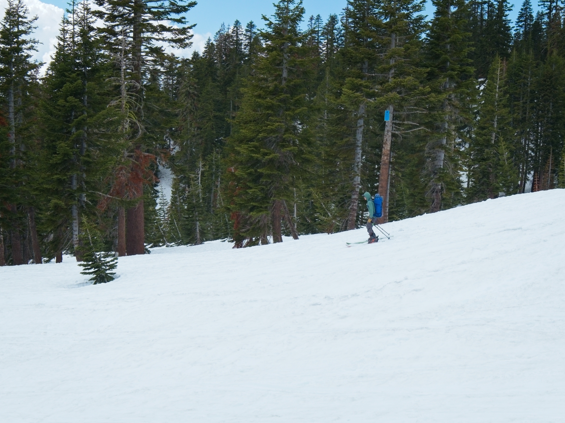
We relax for a little while and eat some lunch before packing up camp. The heat feels oppressive today and I’m eager to get off of the sun-baked snow and down into the trees. We’re on our way by 13:30, Josh and I on skis, Jack on foot (he’s had enough wet glissading for the day). The snow has the consistency of mashed potatoes and I don’t really enjoy the skiing much, but it’s certainly more fun than walking… sorry Jack! Josh and I wait for Jack in the shade of some pine trees at Horse Camp. He’s not far behind us so we don’t have long to wait.
I really enjoy the last mile of skiing to the trailhead. Sure, the snow is a sticky mess, but if I keep to the existing track it’s quite slippery and I enjoy zipping through the trees.
But as fun as the skiing is, nothing beats the satisfaction of reaching the car and pulling off my boots. In contrast to the day we arrived, it’s a balmy 65 degrees at the trailhead this afternoon so it’s quite comfortable to lounge around. Josh arrives soon after me with Jack just a few minutes behind him. We all change into drier, cleaner, and more comfortable clothes while staring up at Mount Shasta. Clouds obscure the upper reaches of the peak and provide a little shade for us as we repack the car. I had a fantastic weekend and can’t wait to ski down some more mountains – it’s so much more fun than hiking out!