This short loop in the San Jacinto Mountains includes some fun class 3 climbing on solid granite, a little cross-country route finding in complex terrain, and a bunch of mellow hiking on the Pacific Crest Trail and adjoining paths. As an added bonus, the loop hits four summits: Tahquitz Rock (a.k.a. Lily Rock), Tahquitz Peak, Grey Tahquitz (a.k.a. Middle Tahquitz), and Red Tahquitz.
Trip Planning
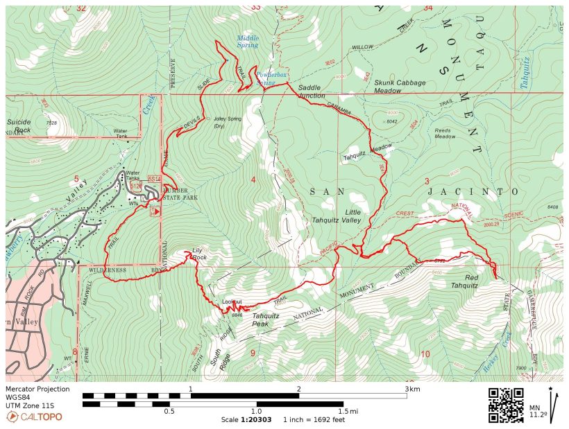
Specs: 10 mi | +/- 3600 ft
Difficulty: Mostly class 1 with some class 2 – 3 terrain to Tahquitz Rock and Tahquitz Peak [learn more]
Location: San Bernardino National Forest, California | Home of the Cahuilla peoples | View on Map
Route: Begin at the Humber State Park trailhead. Hike southwest along the Ernie Maxwell trail for about 0.6 miles and then strike out cross country, scrambling up a creek bed toward Tahquitz Rock (a.k.a. Lily Rock). Higher up the slope numerous use trails and cairns mark routes around the base of the rock; head for saddle to the east of the rock. From the saddle, scramble up a few easy (but exposed) class 3 problems to the summit.
The next challenge is the traverse over to Tahquitz Peak. It isn’t very well marked, but you generally stay at or above 8000 feet. Join the South Ridge Trail and follow it to the lookout tower at the summit. From this peak, follow the trail toward Saddle Junction until you reach the Pacific Crest Trail (PCT), and then hike east (south bound) for a bit until you’re below Grey Tahquitz. The north slope is a pretty straightforward scramble, so head up wherever strikes your fancy. Once on the ridge, continue to the summit. To reach Red Tahquitz, follow the ridge east to the obvious, red-hued mountain.
A well-traveled use trail descends from Red Tahquitz back to the PCT. Hike over to Saddle Junction and then follow the Devil’s Slide Trail back to the trailhead.
Permits & Regulations: As of the date of this trip, a permit is required for day or overnight use. Between Labor Day and Memorial Day (see their website for precise dates) these permits are self-issued at the Idyllwild Ranger Station; during the summer season the permits are limited on weekends and can only be acquired by contacting the rangers. An Adventure Pass or Interagency Pass is required to park at the trailhead. Finally, all the usual leave-no-trace rules apply!
Resources: Visit the San Bernardino National Forest website for current conditions, permit requirements, and other helpful info. I recommend the Tom Harrison San Jacinto Wilderness map when hiking in this area.
Detailed Report
7 May 2022 | 10 mi | +/- 3600 ft | View on Map
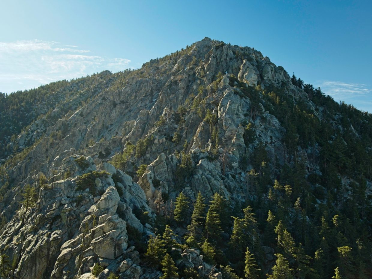
The ranger station parking lot is already filling up when I arrive just before 7 AM. Thankfully, the day use permits are unlimited this early in the year so there’s no competition for access. After filling in the permit, I drive up to the Humber Park trailhead and begin walking down the Ernie Maxwell Trail. It’s an easy stroll for a few minutes, but gets much more difficult when I reach the “southwest chute” below Tahquitz Rock. To be honest, it looks like there are at least half a dozen small chutes and creekbeds on the southwest side of the granite dome and I suspect they’ll all get you up to the base of the rock. The chute I’ve chosen to scramble up is fairly wide and full of rocks, which are a much easier medium to step on than the soft dirt on the sides of the chute. I try to moderate my pace but still end up stopping a few times to catch my breath.


Perhaps 40 minutes after leaving the trailhead I reach the base of Tahquitz Rock and enjoy some nice views of the granite walls. A few climbing parties are already at the base setting up for their ascents. I continue scrambling on the relatively easy class 2 -3 terrain below the vertical class 5 walls, choosing some fun lines up granite slabs. Soon I reach the saddle to the southeast of the summit and begin the short scramble up to the very top. It’s pretty easy climbing (class 3) but a few of the moves enjoy considerable exposure (30+ feet) which motivates me to be very careful with my hand and foot placements. By 8:20 I’m at the summit; I sign the register, snap a few photos, and then carefully descend back to the saddle.

The next challenge is to navigate over to Tahquitz Peak. I’m (roughly) following a GPS track published by Greg Gerlach, so I study the map before leaving the saddle. From here, it looks like a jumble of steep slopes and granite cliffs, but I’m sure the traverse isn’t too terrible since none of the trip reports I read when preparing for this hike make any mention of it. Staying at approximately 8000 feet, I wind through the woods, following the best path I can cobble together. I reach dead ends a few times – mostly steep rock walls I’m not willing to climb – but eventually find a more established social trail marked by cairns. The cairns lead me to the South Ridge Trail, which climbs gently to the summit via a series of switchbacks. I check my watch: 9:20 AM, just one hour from the last summit!


After wandering around the Tahquitz Peak summit for a few minutes (no register to be found), I sit down for a snack and to apply sunscreen. A shuttered fire lookout tower is the most prominent feature up here. Ironically, many of the surrounding trees are charred husks, remnants of the 2018 Cranston Fire. In fact, the entire southeast side of the ridge is still heavily fire-scarred. The other side sports plenty of live trees, though the fire did make it over the ridge in a few places.
From Tahquitz Peak I hike down the trail toward Saddle Junction, stepping over a few lingering snow drifts on the way. At the intersection with the Pacific Crest Trail (PCT), I hook a right and head downhill into the woods. It feels a bit toasty down here below the ridge line; I miss the cool breeze! There aren’t many people out here yet, just a solitary PCT hiker, so it’s nice and quiet.
After walking down the PCT for half an hour or so I leave the trail once again and begin hiking up the ridge toward Grey Tahquitz. There’s no social trail here, but navigating up the slope proves very simple. Once I reach the ridge crest, I follow it east to the highest point and begin hunting for the summit register. I eventually find it safely tucked into two nested tin cans and sign the little book (10:20 AM). The oldest signature in it is from 1994!
The hike over to Red Tahquitz is the easiest summit approach of the day: a flat, open ridge walk. I find the terrain a little eerie: dozens of closely packed, burnt-to-a-crisp tree trunks surrounded by dark red soil and rocks. Some of the trees are barely standing; only thin slivers of blackened wood connect the trunks to the roots. With a stiff wind blowing across the ridge, I hurry up to the summit and sign the register (10:40 AM). This one was left by Greg and Laura a few years ago and doesn’t have too many signatures yet.
 is littered with boulders")


A well-established use trail connects Red Tahquitz to the PCT. On my way back I meet a few more PCT thru hikers lounging beside a small creek. Rather than following the PCT all the way back to Saddle Junction, I divert through Little Tahquitz Valley. I can’t tell if the meadows are just beginning to turn green or are already turning brown… hopefully the former. As I stroll through the valley I contemplate adding some more peaks to the itinerary since it’s still quite early in the day. Marion Mountain, a 10,000-foot peak just ahead is calling to me but I resolve to wait to make a decision until I reach Saddle Junction.


At 11:45 I arrive at Saddle Junction and find a shaded log to sit on. I inspect the map while I munch on snacks, weighing options for the rest of the day. Marion Mountain is certainly doable; it would add about 6 – 8 miles and another 2000 feet of gain. I figure that’s an extra four hours, which I certainly have time for. However, there’s a whole string of peaks up there that I haven’t visited yet: Marion, Shirley, Jean, and Newton Drury. In the end I decide to save those mountains for a future trip. It will be nice to get home before dark, and keeping today’s hike on the short side means I’ll feel refreshed for more outside activities tomorrow.
Once I’ve finished snacking, I head down the Devils Slide Trail to the trailhead. I pass dozens of people on their way up and cheerfully greet several groups of thru hikers heading back to the trail. I’m not a huge fan of the long switchbacks — they seem to stretch on forever — but eventually reach the (now packed) parking lot at about 12:30. Despite all the cars, it’s pretty quiet; everyone’s already out on the trail. I relax in the shade and eat some lunch before changing into shorts and sandals for the drive home. This was a fun hike, definitely a great way to spend the morning!