With snow already falling in the Sierra Nevada and temperatures dipping into the “chilly” range here in LA, it’s time to get back to hiking in the local mountains! This weekend I spent a day bushwhacking through the San Jacinto Wilderness to visit a string of peaks on the Sierra Club’s “Hundred Peaks Section” list. Most of them have very little prominence so I’m not sure why they made it onto the list, but visiting all of them makes for a nice day hike!
Trip Planning
Specs: 18.1 mi | +/- 6700 ft
Difficulty: Mostly class 1 with scattered bits of class 2 – 3 and a small section of class 4 – 5 on Cornell Peak [learn more]
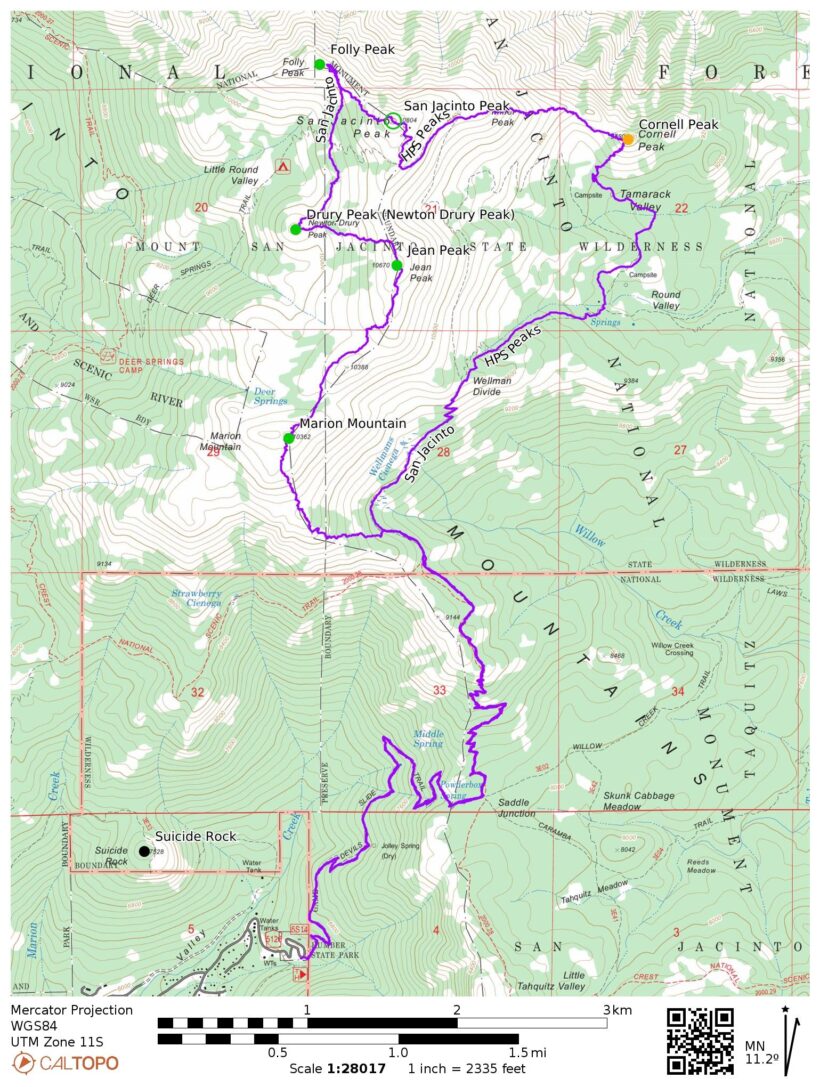
Location: San Bernardino National Forest, California | Home of the Cahuilla people | View on Map
Route: Hike up the Devils Slide Trail to the PCT, then head north. At or just past the junction with the trail to Wellman Divide, leave the trail and hike cross-country up the ridge through patches of dense brush to Marion Peak. Traverse across the ridge to Jean Peak, then head downhill to the west to reach Newton Drury Peak. Contour across the upper slopes of Little Round Valley to reach a saddle and then scramble over some large granite boulders to Folly Peak. Backtrack to the saddle, then hike up the ridge to San Jacinto Peak. Follow the trail through one switchback and then hike cross-country down the east ridge of San Jacinto Peak to Cornell Peak. I think the easiest route to this final summit is from the southeast, but I haven’t verified that in person yet! Finally, hike south from Cornell Peak to the campsite below and then follow trails to Wellman Divide, Saddle Junction, and the Humber Park Trailhead.
Permits & Regulations: A permit is required for day or overnight use. Between Labor Day and Memorial Day (see their website for precise dates) these permits are self-issued at the Idyllwild Ranger Station; during the summer season the permits are limited on weekends and can only be acquired by contacting the rangers. An Adventure Pass or Interagency Pass is required to park at the trailhead. Finally, all the usual leave-no-trace rules apply!
Resources: Visit the San Bernardino National Forest website for current conditions, permit requirements, and other helpful info. I recommend the Tom Harrison San Jacinto Wilderness map when hiking in this area.
Bushwhacking
5 Nov 2022 | 18.1 mi | +/- 6700 ft | View on Map
I’m up this morning at 4:30 AM, hours before sunrise, and in the car a little after 5:00. It takes me almost exactly two hours to drive to the Humber Park Trailhead, not counting a short stop on the way to fill out a day-use permit at the Idyllwild ranger station. Along the way I’m treated to a beautiful display of sunrise color. By 7:30, the color has mostly faded and I’m on my way up the trail.
It’s chilly this morning! My car thermometer on the way in dropped as low as 39 degrees, though I think it rose to 41 at the trailhead. The Devil’s Slide Trail is west-facing, so there’s no sunlight to warm things up yet but hurrying up the trail is enough to keep me feeling toasty. Golden oak leaves and acorns litter the lower half of the trail, but I don’t stop for photos since there’s not much light making it through the trees.
I reach Saddle Junction, the intersection of the Devil’s Slide Trail with the Pacific Crest Trail, among others, at 8:30. Under warmer circumstances it’s a lovely place to sit and rest, but the sun hasn’t quite made it high enough to reach the forest floor so I keep on walking. I follow the PCT northbound, both literally (I’m walking north) and in the more general sense that if I were to keep following this trail I would reach Canada… eventually.


After several switchbacks I finally find a sunny spot to sit, eat a snack, and apply sunscreen. A hiker I passed lower on the trail leap-frogs me, saying hello as he hurries past. I’m soon on my way again, anxious to be speedy for the few on-trail miles remaining so that I’ll have enough time for the off-trail portion of today’s adventure. I have to be careful not to push too hard, however; I have many miles to go and, perhaps more importantly, many thousands of feet left to ascend.
About an hour after my snack break I reach another trail junction. The PCT turns left and contours around Mount San Jacinto while another path leads to Wellman Divide. Somewhere around here I need to abandon the trail and hoof it cross-country up the ridge to Marion Mountain, but I stay on the Wellman Divide trail a little while longer. I can see slopes carpeted in thick brush ahead of me and am not eager to try climbing through it, so I split off from the trail and begin a steep climb up the ridge.
For a little while the walking is easy enough. It’s steep, but I’m stepping on rocks and pine needles. The simple terrain ends a few hundred feet up the ridge when I reach a wall of waist-high bushes. They cover most of the ridge around me and, from what I’ve been able to see during the hike up, much of the route to Marion Mountain. There’s not much to do besides walk through them, so I begin my best high-knee march through the sticks.
Although I’m able to find plenty of clear areas between patches of the brush for a little while, the bushes grow thicker as I climb higher. Stepping through them is terribly tedious work and I’m glad I’m wearing pants instead of shorts; I would surely be bleeding all over the bushes without them. As I near Marion Mountain I’m occasionally able to scramble over and between large granite slabs, though some are covered in a layer of ice that’s difficult to see. There’s also plenty of ice still clinging to the tree tops from a storm earlier this week; the breeze sends pieces crashing down around me, adding to piles of misshapen ice cubes already on the ground.
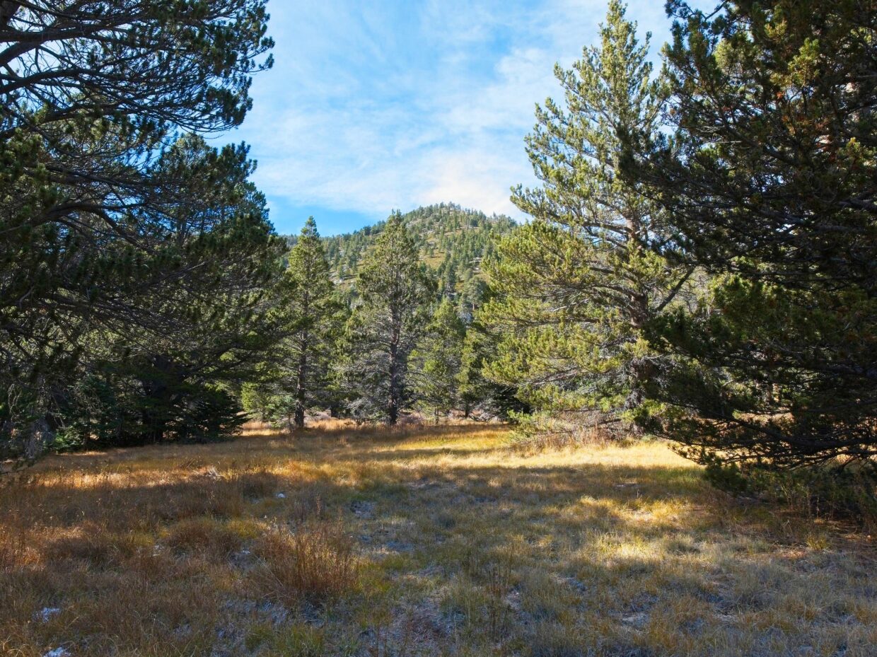
After what feels like many hours, I reach wonderfully simple dirt once more and hurry up to the summit of Marion Mountain, arriving at 10:20. It’s not a very scenic view, what with the plentiful trees and large boulders on every side. I scramble around the rocks for a few minutes, searching for a summit register, but give up pretty quickly when I can’t find it.
A stiff breeze is chilling me to the bone, so I pull on a wind breaker and then hurry down the north side of Marion Mountain. The brush is gone but much of the ground is covered in snow and ice! I’m careful to avoid the slippery rocks but kind of enjoy crunching through the piles of clinking ice cubes.
Once I reach the foot of Jean Peak and begin climbing, I have to stop again to take off the wind breaker; it’s tough to maintain a comfortable temperature today! Thankfully I haven’t had to descend very far and only have a hundred feet or so to gain the summit. Jean Peak is a little more open than Marion Mountain and somehow also less windy, so I enjoy a sit-down break on a sunny patch of dirt (no summit register again).
After a long rest, I set off for the next summit on my itinerary: Newton Drury Peak. It’s down the slope to the west, which means I have to give up some of this hard-fought altitude. The descent isn’t too difficult; there are a few patches of the thick bushes but I’m mostly able to avoid them and trek down dirt and rock. I reach the summit at 11:30 and decide it’s high time for lunch. I’m hungry! There is a summit register on Newton Drury, although it was only placed in August, so there aren’t many signatures in it yet.
Newton Drury Peak has some of the best views so far. Looking east I can see a few cities and Diamond Valley Lake; LA is somewhere out there over the horizon. Mount San Jacinto stands tall to the northeast and I see Jean Peak, Marion Mountain, and Folly Peak on its south and northwest ridges. I’m heading for Folly Peak next and am not stoked about the amount of brush between here and there. It’s a ways off, though, so there may be routes between the bushes that I can’t see from here.


Once I’ve finished eating lunch I descend back down Newton Drury Peak to the west and then begin walking north toward Folly Peak. I do end up bushwhacking through several dense thickets but am able to avoid most of the brush by going up and around them. As I hike along I spot two men paralleling my path; I’m surprised to find other people out here cross-country hiking! Only moments later, as I get closer to them, I realize they’re on the established trail.
I’m not done with my cross-country travels yet, so I step across the trail and continue up the hill toward Folly Peak. Locating the summit proves to be a bit of a challenge. It’s a very flat mountaintop and is covered in trees and boulders, like Marion Mountain. I hike to the highest point I can find and look for a summit register, but can’t find one. There don’t seem to be many up here.
With Folly Peak in the bag, I only have one more to hit: Cornell Peak. It’s on the other side of San Jacinto Peak and the shortest route to reach it is to head up the ridge to San Jacinto itself and then down the other side. So up I go, through more patches of snow, to the 10,800-foot summit. Several dozen people are enjoying the views when I arrive at 13:00, by far the largest number of people I’ve seen all day. I spot one of the hikers I was leap-frogging with earlier on the trail and go over to say hello. We chat for a few minutes, admiring the mountain oasis with desert all around.


I don’t stay for long on San Jacinto Peak: I’ve been up here several times before and it’s cold! I pass many more hikers on the trail down to the saddle between Miller Peak and San Jacinto but quickly ditch the crowds when I set off cross-country down the ridge. After a few short patches of bushwhacking, I’m speeding down talus and dirt toward Cornell Peak.
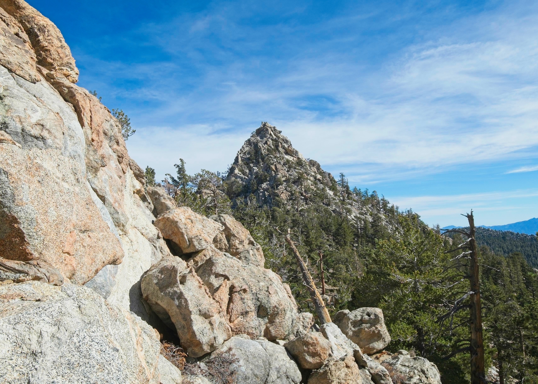
Only 45 minutes after leaving San Jacinto Peak, I’m standing at the foot of Cornell Peak looking up at the rugged spire. Supposedly the top has a few class 4 moves and I’m excited to try them out. So I scramble up the class 2 – 3 rock, following what looks like a very faint use trail, to the highest point I can see. After scrambling up a short class 4 wall I reach a rather exposed 8-foot wall of slightly overhung 5th class rock. There’s a sling up out of reach and I try a few of the hand holds but don’t feel comfortable committing to the moves. Also, the wind has really picked up and is howling across the peak, so I decide to head down. It’s already 14:00 and I still have eight miles to return to the trailhead!
Near the foot of Cornell Peak I find the established campsites and follow the trail back to the Round Valley Ranger station. I’ve never actually seen it open, having only walked past it in Nov and Dec; it looks like a neat location though! On my way up to Wellman Divide I pass a bunch of hikers on their way down including several that I saw on the summit. I’m moving pretty slowly now and it’s very cold with the shade and wind, so I put on some gloves and a warmer jacket. Even after cresting the ridge and reemerging into the sunshine, I keep the layers on.


The last five and a half miles from Wellman Divide to the trailhead pass slowly for me. My legs ache from the long day of difficult hiking and the now-constant downhill grade. The afternoon light is rather pretty though, so I try to distract myself with the scenery. I’m surprised to find the Wellman’s Cienega spring flowing; all of the ferns surrounding the mountainside “wetland” are golden brown, so I expected the spring to be dry. By the time I reach the bottom of the Devil’s Slide Trail a few hours later, the sun has nearly set and is bathing the oak trees in warm light. There’s a small clearing with a few oak trees and a clear view of Tahquitz Rock; the light hits the trees perfectly for a photo!


I’m surprised to find the trailhead parking lot almost completely empty when I arrive at 17:30. Judging by the cars parked way down the road, it was completely full at some point today! I don’t mind the quiet though and spend a good 10 minutes stretching before getting into the car. The setting sun paints the clouds pink and purple, a satisfyingly symmetric ending to a day that began with a colorful sunrise.
Craig Barlow 21 November 2022
I think you missed the HPS summit of Marion Mountain. The point marked 10,362′ is not actually the highpoint (I think). That is within the contour to the west and is a Class 3 scramble up a crack to the top. It’s pretty fun and probably where the register located.
Andrew 29 November 2022 — Post Author
Mm, interesting! I do see several points now when I zoom in really close. I suppose I’ll have to go back then 😀