The Sierra have not gotten much snow this spring so I figured I would venture out and see what the conditions are like firsthand. After all, permits are easy to come by this time of year and shoulder season can be truly beautiful with blooming flowers and mild temperatures. As luck would have it, the Sierra got a light dusting of snow the night before I began this little trip, turning the upper reaches of the mountains into a springtime “winter wonderland.” My goal was to climb Olancha Peak, the southernmost mountain in California to rise over 12,000 feet and also one of the “Sierra Emblem Peaks.”
Trip Planning
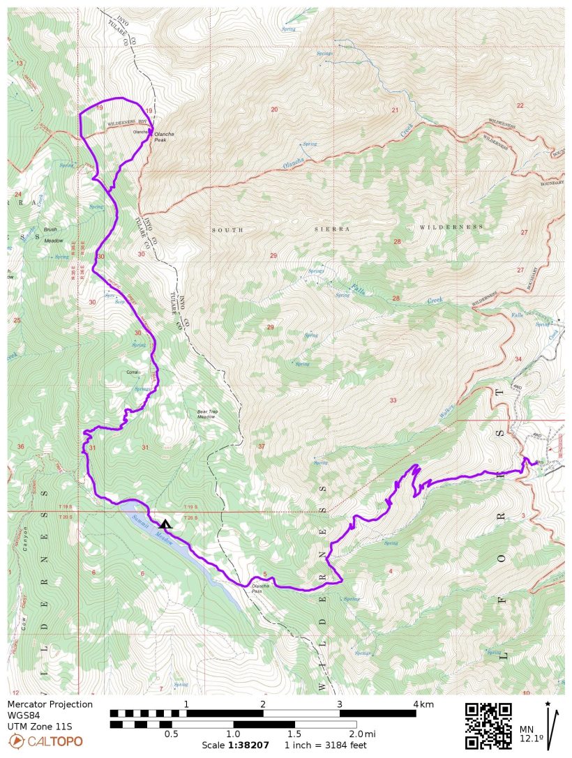
Specs: 21.3 mi | +/- 6500 ft | 1 day, 1 night
Difficulty: Mostly class 1; some class 2 – 3 near summit of Olancha Peak [learn more]
Location: Inyo National Forest, California | Home of the Tubatulabal, Northern Paiute, and Western Shoshone peoples | View on Map
Route: Begin at the Sage Flats / Olancha Pass trailhead just south of the town of Olancha. Hike up the trail to the far (west) end of Summit Meadow, then follow a short connector trail to the Pacific Crest Trail (PCT). Take the PCT north-bound until you’re below Olancha Peak. You can scramble directly up the steep west face (class 2 – 3), or continue along the PCT to the saddle directly SW of the summit. Leave the trail at the saddle and contour NW along the 10600-foot line, staying high when in doubt. Once past the ridge with the rocky outcroppings, trend uphill and right (E) to reach the shallow, sandy, north slopes of Olancha Peak (easy class 1 to the summit). If you do climb the more direct route, this easier north side makes for a relaxing descent.
Permits & Regulations: Wilderness Permits are not required for overnight trips into the South Sierra Wilderness, but they are strongly recommended. Like most of the Sierra Nevada, food must be stored in bear-proof containers, and there are limits on party size. As always, practice leave no trace!
Resources: The Inyo National Forest website for the Olancha Pass trailhead includes lots of information about the trail, current conditions, and the applicable rules and regulations. For navigation, I recommend the Tom Harrison map for the Golden Trout Wilderness.
Hike to Summit Meadow
22 April 2022 | 5.3 mi | +3300 / -0 ft | View on Map
I pull into the trailhead parking lot at about 1:15 PM; mine is the only car in the lot, but it is Friday, so the rest of the weekend warriors may not be out yet. Fluffy clouds drift overhead, casting shadows over the landscape as I change into hiking shoes and double check that I’ve got all my gear. A very loud frog croaks in the creek bed below the parking lot, though I can’t see or hear any running water. But I imagine it’s there somewhere; the rain and snow last night must have funneled into the creeks by now.
The soft earth beneath my feet feels nice as I begin the hike to Olancha Pass; another plus from the precipitation last night! Just a few minutes up the trail I spot a line of well-defined mountain lion tracks, which gives me pause for a minute or two. Judging by the clarity of the prints, my guess is that the cat walked down the trail early this morning, sometime after the rain stopped. The direction of the prints do show that it walked down the trail, though it could very well have ascended via a different route. I don’t really consider turning around; I’ve probably crossed paths with dozens of mountain lions over the years. The only difference today is that the ground is soft enough to show its passing.


A few wildflowers are blooming already! The lupine is in fine form, and bunches of yellow threadleaf groundsel add splashes of bright color to the otherwise dull greens of the sage brush and prickly pear cacti. After climbing a few switchbacks I arrive at a ramshackle barbed wire fence and a sign marking the beginning of the South Sierra Wilderness. The path parallels the fence for a few hundred feet before passing through a farm gate and leaving the fence behind.


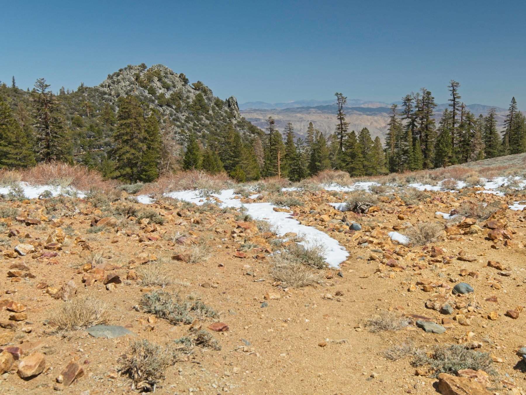
The sun dips in and out of the cloud cover and a few rogue snowflakes drift past as I walk further into the wilderness. The wide, rocky path soon branches into two routes. One, marked by a “Cattle Driveway” sign, continues up the floor of the canyon. The hiking trail makes a 180-degree turn and begins climbing to the top of the ridge via gently graded switchbacks. After completing a few of them, I’m treated to lovely views of snow-dusted mountains. As an added plus, the clouds seem to be thinning out!

Further up the trail I run into the mountain lion tracks again. There aren’t any other prints, not even from people; it’s just me and the mountain lion out here today. As I gain altitude, the trail is increasingly covered in snow. There’s not too much of it — just a couple inches — and it’s nice and fluffy since it’s so new. I don’t even bother to put on microspikes, I just walk on through. I do put on a jacket and some gloves though!


By the time I reach the saddle at 8700-feet I can feel the altitude beginning to effect me. Thankfully, the trail isn’t steep and the scenery is gorgeous so I slow down a little but continue walking. I arrive at Olancha Pass (9200 ft) a little later and pull on an extra layer to keep out the chilly wind. Snow drifts a foot or two deep cross the trail at diagonals, but they’re infrequent enough that I can’t bothered to put on gaiters.
The mixture of sage brush and mountain mahogany at Olancha Pass feels a little out of place to me this high into the mountains, but this is my first foray into the South Sierra Wilderness – maybe everything is just a little drier here than the northern parts of the range? I still haven’t seen any running water, but I’m hopeful that Summit Meadow will have a few pools to fill my bottles from. Every topographic map I’ve found depicts the meadow as a lake, which isn’t too uncommon in these mountains. Oftentimes a meadow will fill with water in the early season and then dry up later in the year.
The trail winds through a shadowed pine forest for a little while, paralleling the open meadow. An even blanket of snow covers the ground beneath the trees; the lack of footprints again confirms that nobody else has passed this way today. I walk to the far (west) end of the meadow, keeping an eye out for campsites in the forest. I don’t really want to pitch my tent on the snow, but dry spots are few and far between. Camping in the meadow isn’t really an option either; the leave-no-trace ethics are clear that campsites should be located on “durable” surfaces, and the spongy meadow turf is not durable.


I do venture out into the meadow to look for water, but don’t find any. There are a surprising number of cow “pies” in the grass though – is this area still used for grazing? A makeshift picnic table, fire pit, and another neglected barbed wire enclosure in the forest nearby make me think the answer may be yes. I search around the area for a little while longer before concluding that there is no liquid water to be found here. Even the small creek from Bear Trap Meadow depicted on the map is completely dry. Melting snow it is!
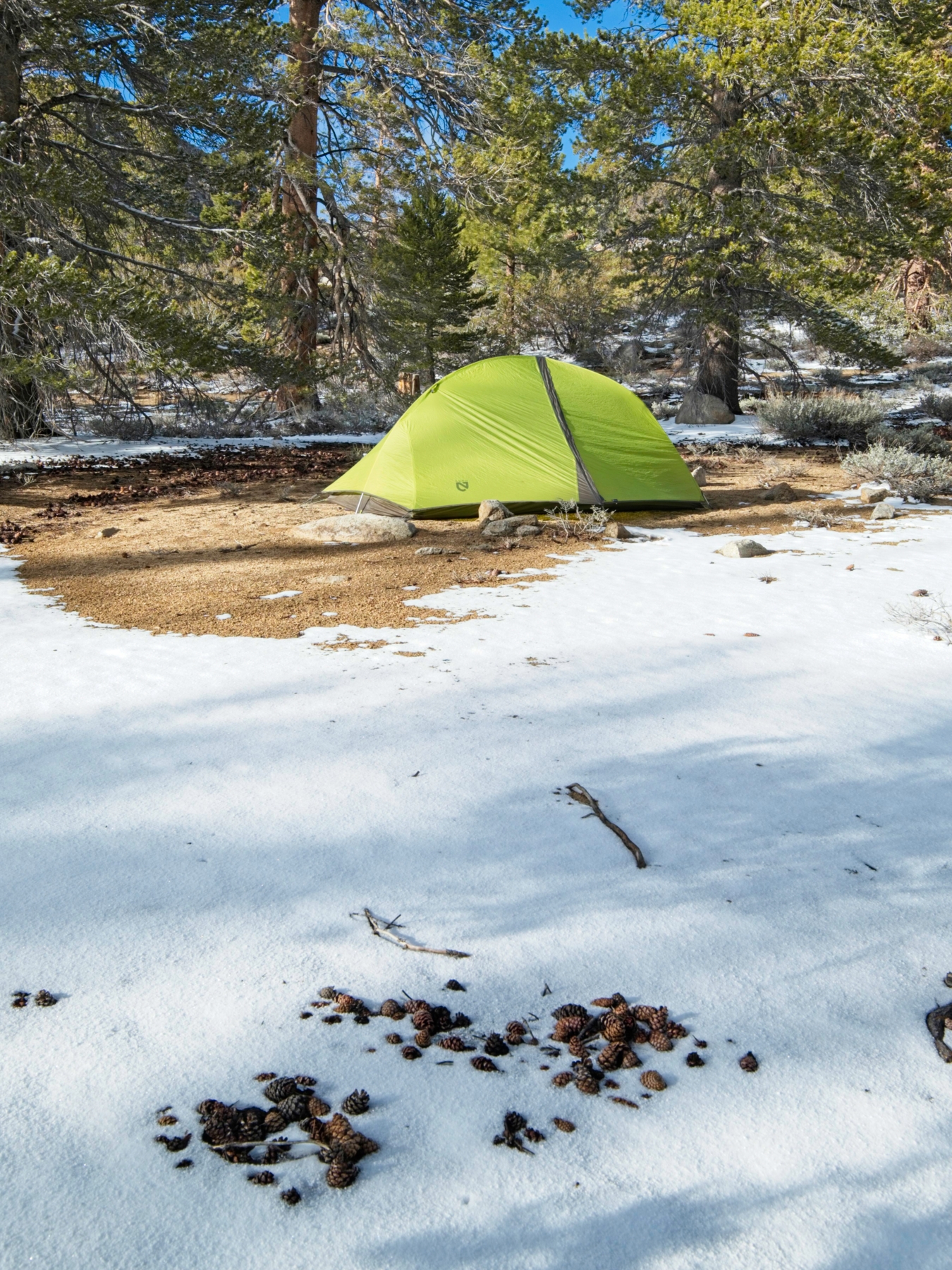
I pitch my tent on a patch of (mostly) dry gravel that seems to be getting lots of sunshine. I check my watch and am a little surprised to see it’s only 5 PM. With several hours of daylight left, I decide to wander around a little and explore. The forest beyond the west end of the meadow offers some stunning pictures with the sun-peeking through the snow-covered pines. It’s almost completely quiet aside from my feet crunching through the snow and the deep “wump, wump, wump” song of a sooty grouse somewhere out there in the forest. I spot a set of coyote prints in the snow and lots of rabbit prints, but no sign of the mountain lion, or of other people for that matter.


After exploring, I return to my sunny patch of gravel and set about melting snow. I’m always surprised how much it reduces down; it’s mostly just air! I refill my water bottles and then boil the rest for dinner: rice and beans with chili cheese Fritos! A little dark chocolate completes the meal nicely. I spend the next 45 minutes lying in the warm tent, listening to a podcast. Before going to bed, I have the brilliant idea to dig a cat hole while the ground is soft. I expect it will freeze solid tonight, so digging one in the morning will require much more effort. With the sun dipping below the horizon, I retreat back to the warmth of my sleeping bag and call it a night.
Olancha Peak
23 April 2022 | 16.0 mi | +3200 / -6500 ft | View on Map
As usual (for me, anyway), I toss and turn throughout the night. There’s just something about sleeping out on the trail that takes some getting used to. Spending the night at 9000+ feet also makes sleeping a little more difficult. But I’m perfectly warm and cozy despite the sub-freezing temperatures and manage to go back to sleep until the skies begin to brighten.
When I venture out to get breakfast from my bear canister I find that the lid is frozen solidly to the can. So I bring it back to the tent to wrestle with from the warm of the sleeping bag. It’s a multi-step process. First I have to un-freeze the lid, and then I have to find a way to bend the cold plastic enough to slip the plastic safety tabs past the bear-proof lip. I eventually open the thing and munch on a cold bagel with cream cheese, a frozen banana, and a piping hot cup of tea.
I begin hiking at about 6:45. The sun isn’t completely up yet, and the trail remains in the shaded forest regardless, so I keep my warm puffy jacket and some even warmer puffy mittens on. Just a short time later I reach the Pacific Crest Trail (PCT) and find boot prints for the first time this trip! I can’t imagine any PCT hikers are this far north yet, but maybe the Sierra passes aren’t too bad? In any case, I enjoy having some footprints to follow, particularly where the snow is deeper and the trail much less obvious.

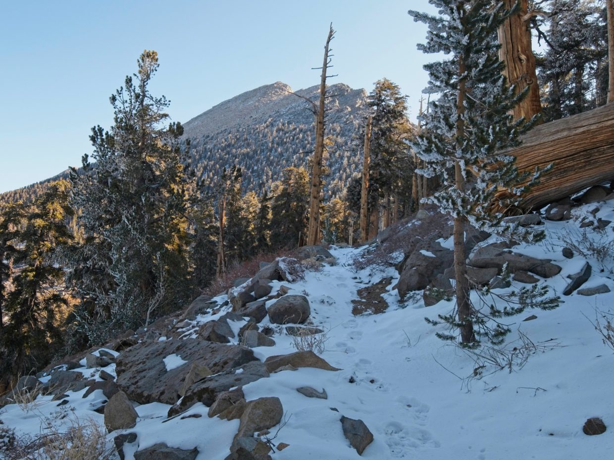
Once the Pacific Crest Trail begins climbing a series of switchbacks, I finally shed a few layers. I also find the first running water of the trip in a tiny creek and note its location for the return journey. For the most part, I’m hiking entirely on snow. The uneven and slippery footing is a little tedious, but not enough to warrant microspikes (at least in my opinion). As I gain altitude, I’m excited to stroll past a collection of “frosted” pine trees sparkling in the morning light. I spotted some up on the ridge from the meadow last night, but seeing them up close is so much more awe-inspiring.

The switchbacks soon end and the PCT contours across a snow-free, west-facing section of the Sierra Crest, offering a nice view of the Kern River twisting through meadows far below. But then the trail dips back into the snow-covered forest and stays there. I get my first glimpse of Olancha Peak as I round a corner and spot its rocky summit far above. The slope is steeper than I expected, but certainly manageable.


I continue along the PCT to a spot somewhere below the summit and then put on my microspikes. They’re a tremendous help as I begin scrambling up the steep slope, navigating through the boulders, manzanita, and fallen trees. The thin air forces me to stop and catch my breath plenty of times on the way up, but I make quick progress and am soon standing in the sunshine on the upper, talus-strewn slopes of the mountain. Here the microspikes are less useful; they help in the snow but make talus-hopping considerably more difficult. I eventually decide I’d prefer the stability on the rocks more than on the snow and stash the spikes in my pack.


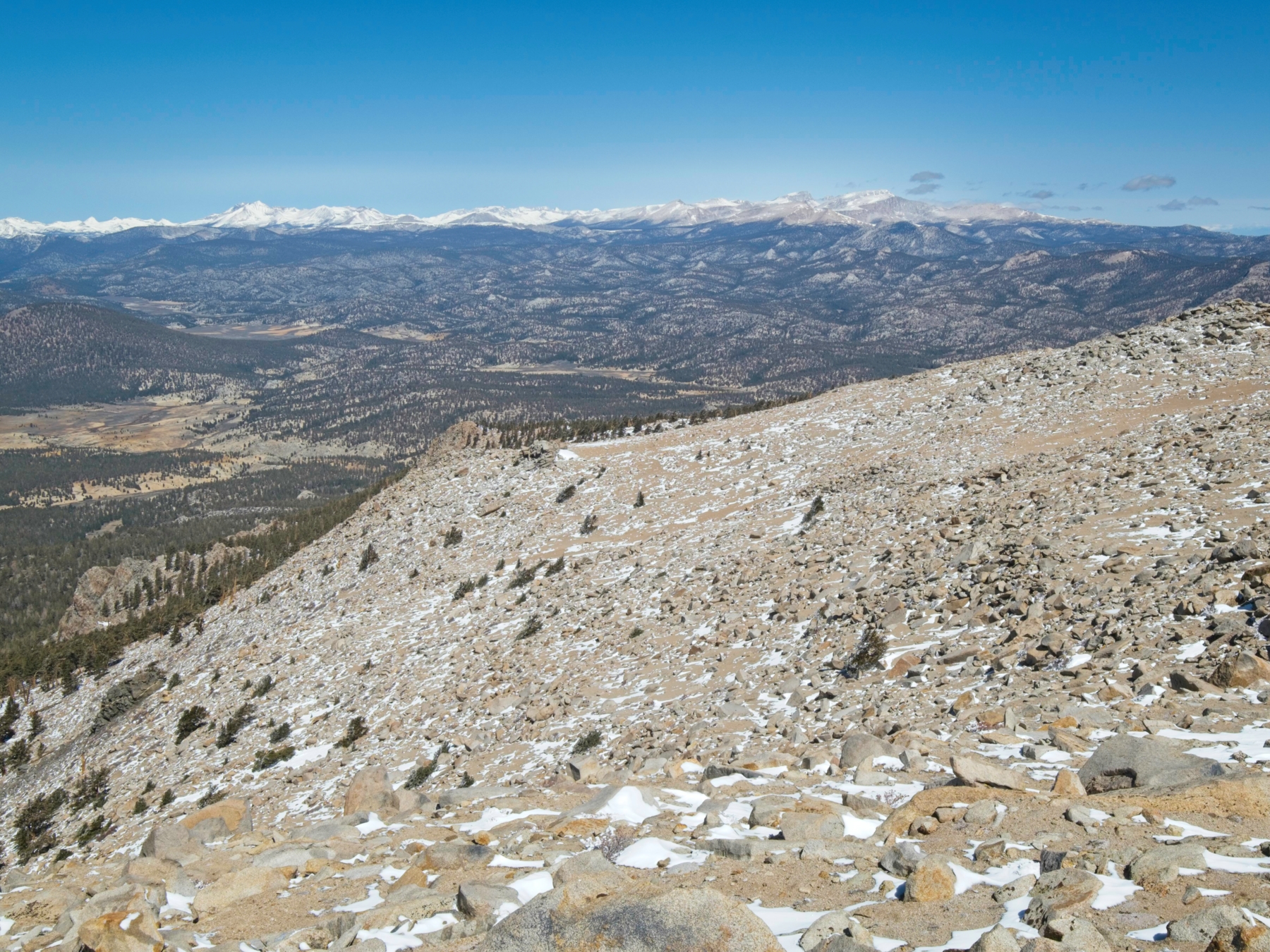
The final 50 feet of ascent prove to be the most difficult. The terrain transitions from class 2 scrambling to class 3, and then to class 4. I’m not eager to do any solo class 4 climbing, particularly with the spotty snow and ice, so I backtrack a little and try approaching the summit from the north. This direction proves much easier, and I’m soon standing at the summit of Olancha Peak! It’s still early in the day (10:15) so I take a nice long break, lounging in the sun and munching on a snack while admiring the view. Mount Langley is the most obvious peak to the north, but Whitney and Russell are both visible beside it! Further west, the Great Western Divide’s snow-capped peaks capture my attention. The wilderness between me and those peaks appears entirely snow-free though… I’m afraid this is going to be a very dry summer.


After a relaxing break (and adding my name to the summit register), I begin the descent. Megan Birdsill recently noted on PeakBagger that descending via the north side of the mountain is much easier than the west face I ascended. I give her advice a chance and have to agree! The north slopes of Olancha Peak are gradual and include lots of soft sand to slide down. I thoroughly enjoy speeding down the easy, class 1 terrain. Once I reach the forest, I head left (south) via a fun and easy cross-country jaunt until I pick up the PCT again.
The hike back on the PCT speeds by. It’s a little warmer now, but I’m still most comfortable with a few layers on. I stop for lunch beside the little creek I found on the way up and pull my puffy on to keep out a chilly breeze. It looks warm out here, but it’s not.


I reach my campsite at about 1:30 PM and pack up my overnight gear. As I stroll back through the woods alongside Summit Meadow, following my own footsteps, I wonder why I haven’t seen any other people out this weekend. I’m not complaining – it’s been a serene experience to hike and camp in these beautiful, snowy woods, but I am a little surprised that there isn’t anyone else here. I guess the South Sierra are not as popular as the spots further north? Or maybe the snow and rain on Thursday kept some people home. At Olancha Pass I find some new footprints and I think I hear a few voices, but never do spot any people.
The hike back down to the trailhead is more pleasant than usual, particularly considering I’ve already hiked 10 or 11 miles today with considerable elevation change. I’m used to afternoon descents in the Eastern Sierra being hot and a little miserable, but that is not the case today! The sun is out and there’s not a cloud in the sky, but the temperature is a comfortable 50 degrees and a light breeze keeps me feeling cozy in my long-sleeved sun hoodie. The mountain lion tracks that were so pronounced yesterday have faded into the ground, except for one very pronounced paw print near the trailhead. I reach the car at about 4:00 and, after some stretching, settle in for the drive back to LA.