Mount Jefferson is the most technical peak I’ve climbed to date, with sections of class 2 talus hopping, class 3 and 4 scrambling, and steep (~ 60 deg) alpine ice climbing. I joined Craig, Linda, Andrew R., and Dagmar for this adventure on days two and three of the Oregon peak-bagging trip.
Trip Planning
Specs: 22.25 mi | +/- 7600 ft | 2 days, 1 nights
Difficulty: Class 4 [learn more] / AI1 (See Ascentionism for ice-climbing grades)
Location: Willamette National Forest, Oregon | Home of the Molalla, Tenino, Warm Springs, and Siletz peoples | View on Map
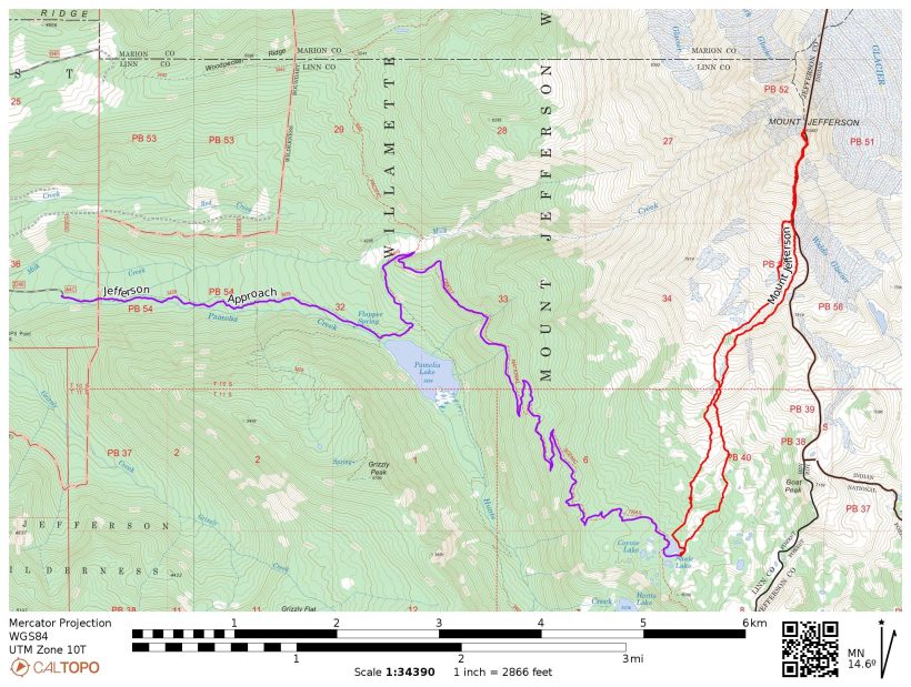
Route: Follow the Pamelia Lake trail and then the PCT to Shale Lake. A climbers’ trail heads north from the east end of the lake, as seen in the right-most red track on the map below. Choose your own route up to the south ridge; I suggest stringing as many snowfields together as you can since the loose, sandy soil is no fun to climb through. Follow the class 1 – 2 south ridge all the way to the “Red Saddle,” the obvious saddle just below (and south of) the summit block covered in red, sandy soil; the terrain immediately before the saddle is class 3 – 4. Our route across the snow follows the rimaye and then cuts directly up the snow to the summit. A short (50 – 100 feet?) class 3 – 4 scramble leads to the top. With less snow, some authors cite this route as easy 5th class rock.
Permits & Regulations: Permits are required for both day and overnight use at the Pamelia Lake Trailhead between June 15 and October 15. Parking at the trailhead also requires a day-use fee or a valid recreation pass. Wilderness regulations apply, and make sure to leave no trace!
Resources: Visit the Pamelia Lake Trailhead website for a full list of resources.
Hike to Shale Lake
24 July 2022 | 7.6 mi | +2900 / -100 ft | View on Map
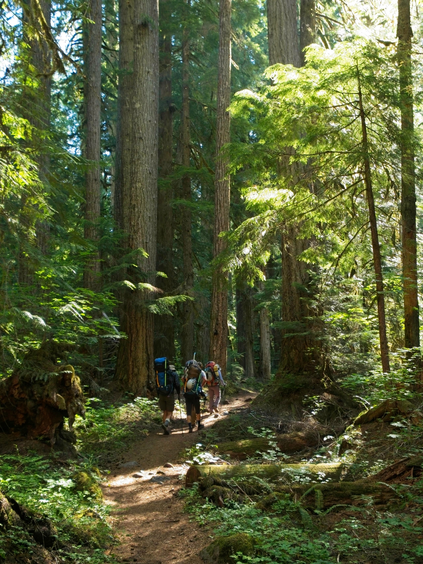
With only a short approach hike to complete today, Linda, Craig, Andrew, Dagmar, and I enjoy a leisurely morning. We spend some time at the Pamelia Lake trailhead packing and distributing group gear and hit the trail at about 9 AM. We’re in the shade from the start, strolling between massive pine trees beside the roaring Pamelia Creek. I end up at the front of the group and reach Pamelia Lake a few minutes before everyone else. I was counting on running water here to refill my water bottles before tackling the 5.5-mile, 2000-foot gain walk to Shale Lake, but the roaring creek is missing. Maybe it’s subterranean here? In any case, the only water source is the stagnant lake. I fill my bottle and am happy to find that, despite the layer of pollen on the surface, the water is perfectly clear.
The rest of the group arrives while I wait for the Aquamira chemical reaction to complete so I can add it to the lake water. They continue up the trail and I’m soon walking again myself, now with plenty of hydration for the hike. I get to know Andrew R. and Dagmar a little better on the hike up, a nice way to pass the time and distract myself from my heavy backpack and the hot weather. I haven’t carried a pack this heavy since climbing Mount Baker two years ago! Besides my backpacking gear, I have mountaineering boots, snow pickets, a climbing harness with assorted hardware, a helmet, and two ice tools. Craig and Andrew have graciously offered to carry the ropes and I don’t try too hard to convince them to let me take a turn.
We reach Shale Lake at about 13:30. Andrew R. and I wander around the area, searching for excellent campsites. I meet a young couple lounging on the shore, enjoying the sunshine and cool water; they’ve got a great campsite and there are a few other nice spots close by, but I keep looking for one a little further away so that we don’t intrude on their space. After a little more scouting, Andrew and I find a nice, shaded clearing surrounded by pine trees with an excellent view of Mount Jefferson and easy access to a small creek of fresh water.
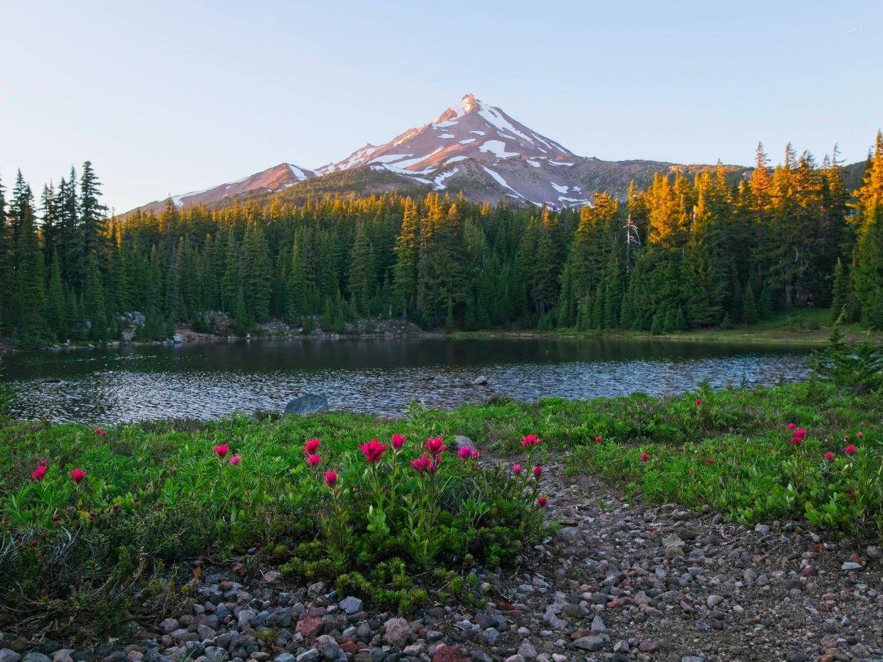
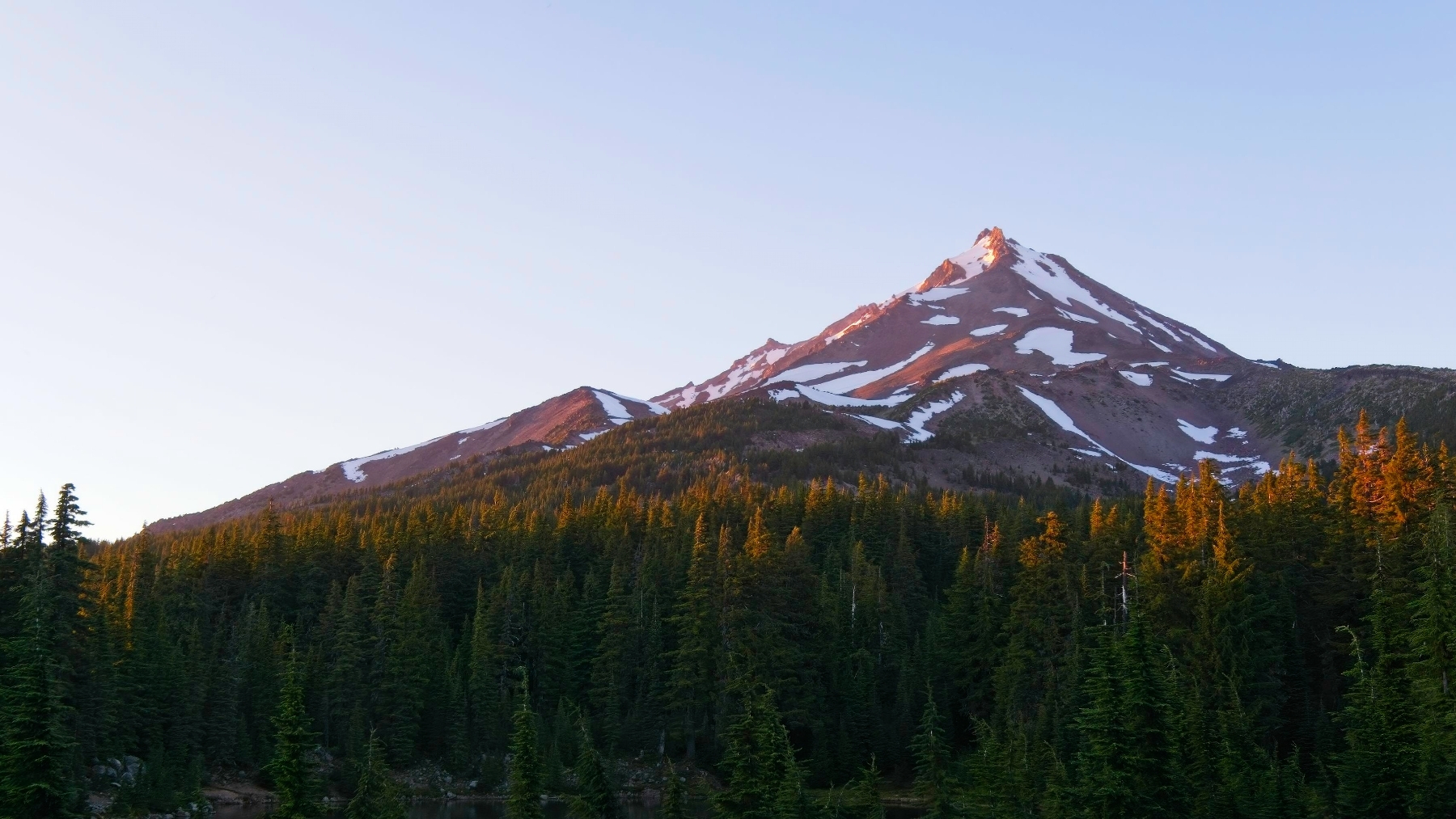
We’re planning to get an early start (5 AM) tomorrow so we spend the rest of the afternoon relaxing in camp. I read for a while, listen to a few podcasts, and take a short nap. A few mosquitoes buzz around, which is enough to keep most of us in our tents when we don’t have a good reason to be outside. They don’t bother me too much though, especially after I put on some bug spray, so I spend an hour or two wandering around the lake in the evening, snapping photos of the wildflowers, the lake, and Mount Jefferson. I also scout out a couple of use trails that head up into the hills toward the peak; we’ll be following one of these in the morning.


I’m trying out a new pair of pants on this hike. Kühl kindly sent me a pair of their Renegade Cargo Convertible pants and so far they’re a pleasure to hike in! They’re a bit thicker than my usual Columbia pants, but I haven’t been too hot in them and they keep the mosquitoes off of my skin. I’m curious to see how they perform tomorrow with mountaineering boots, crampons, and snow.
The sun sets around 20:30 and I head to bed as soon as the alpenglow has faded from Mount Jefferson. Tomorrow is going to be a long, difficult day and I want to be as well-rested as possible.
Mount Jefferson Climb
24 July 2022 | 14.65 mi | +4700 / -7500 ft | View on Map
My alarm wakes me up at 4:00, well before dawn. I eat some granola for breakfast and pack up my climbing gear. We set off shortly after 5:00, connecting up with a climbers’ trail that departs from the PCT at the outlet of Shale Lake. Despite the early hour, it’s already warm out… the dense pine trees have trapped pockets of uncomfortably humid 80-degree air. We soon loose the climbers’ trail and end up bushwhacking through a few patches of dense brush until we reach rockier slopes.


Although the rocky and sandy soil saves us from bushwhacking, the slope steepens to the point where ascending in the sand becomes terribly tedious. There isn’t an obviously better way to climb up to the south ridge of Mount Jefferson, so I put my head down and struggle onwards. We stop once to redistribute some of the group gear but otherwise continue the steady trudge upwards.
After what feels like a very long time, we reach the top of a southwest-angled ridge and scramble through loose talus just below the crest until we reach the south ridge proper. From here the route to the summit area is incredibly straightforward: follow the ridge all the way up. We all settle into a slow, steady pace and trudge on for two more hours, gaining another two thousand feet. Climbing through the sand and talus is an exercise in maintained suffering… you can push your body to do a lot if you pick the right pace.


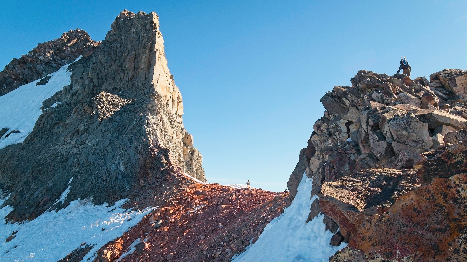
The final challenge before reaching the snow traverse is a class 4 scramble through large boulders. I don’t feel particularly secure with my heavy backpack, but I take my time and arrive at the “red saddle” with the others at about 9:00. The saddle offers an impressive view of the towering summit pinnacle; our route traverses the steep snow field on the west side of the peak, curving around to the north aspect where we can scramble up class 3 – 4 rock to the top.
Since the snow is icy and steep (up to 60 degrees, by our estimates), we rope up and put on mountaineering boots and crampons. I’m pleased to find that the Kühl pants easily fit around the mountaineering boots. Andrew R. leads the first pitch, placing rock gear, snow pickets, and ice screws along the way while Dagmar belays. Linda follows 30 meters behind Andrew, tied into the first rope on a running belay. Craig is the middle man, tied into both of the ropes. I follow behind Craig, and Dagmar cleans the route at the end of the second rope.
My snow mountaineering experience thus far has been mostly limited to low- and moderate-angle snow, so I’m a little nervous for this traverse. I set out across the icy crust as soon as Craig is 30m out, stepping gingerly around the coiled rope at Dagmar’s feet. My crampons easily grip the snow and the angle is shallow enough for now that I can walk upright without using the ice tools in my hands. Andrew’s route follows the rock face, dropping into the rimaye (a.k.a. randkluft, the moat between the melting snow and rock face), which makes for easy walking with no risk of sliding down the slope.
Scrambling up and out of the rimaye is a little tough, but I manage it after a few false starts and proceed up steeper snow toward the anchor where Andrew is belaying us. I’m soon dripping sweat – I foolishly put on warmer layers while waiting to climb and am now overheating in full sun. The exposure and long runout below me are cause enough for a little perspiration on their own as well. This isn’t the route we intended to climb (the plan was to traverse laterally across the snow, not climb uphill) but I trust Andrew’s route choices. In any case, climbing directly up is less nerve-wracking than traversing and the snow feels very firm. With a little coaching from Andrew, I make it up to the anchor without incident and squeeze in with the others, clipping in to the anchor while we wait for Dagmar to complete the climb.


Rather than traversing across the snowfield, Andrew R. lobbies to continue climbing directly up the snow to just below the summit. The route descriptions I’ve read describe the rock above as easy 5th class, so it will certainly be climbable. The vertical climb is also considerably shorter than a line that traverses, so we agree to the updated plan. Dagmar leads the second pitch, placing a few pickets up to a set of slings at the foot of the rock wall. Rather than setting up a belay, we climb a fixed line. A prusik hitch keeps me from sliding too far if I slip and a carabiner clipped around the rope will prevent me from falling any further than the last picket.


I follow Linda up the last pitch. Instead of waiting at the anchor (there’s not much space to sit or stand), I decide to climb up a little higher. A nice ramp just above the anchor leads to a small bench where I take off my crampons and stow my ice axe and ice tool but leave my mountaineering boots on. We’re only a short distance below the summit and I’m going to have to put them back on to reverse the snow climb anyway. I lead the way up straightforward class 3 – 4 rock to the summit, arriving just after noon. I make myself as comfortable as I can and munch on pita bread and peanut butter. Once everyone has reached the top, we take a summit selfie and enjoy the achievement!


Reversing the climb takes less effort but just as much time as the ascent. We all scramble down to just below the summit and rappel down the 4th class rock to the anchor at the top of the snow slope. Andrew R. sets up a two-rope rappel and makes his way down the slope. With both ropes tied together, he’s just barely able to make it back to the rimaye.
Once Andrew has built an anchor the rest of us rappel down to join him. It’s close quarters up at the top anchor and we’re extra careful to avoid sending loose rocks careening down the slope. When it’s my turn, I carefully step out onto the slope and make my way down. A few of my steps sink deep into the soft snow; excavating myself without letting go of the rope takes a little work, but thankfully the weight of the fully-extended ropes prevents the belay device from slipping. As I near the bottom of the rappel, the ropes stretch and bounce, which makes the final few meters a bit difficult to control. But I’m down soon enough and cram into the rimaye beside Andrew, Craig and Linda. Dagmar rappels down last and then Andrew pulls the ropes. We all duck in cover as he finagles the rope around loose rocks on the slope above and then wait patiently as he leads the way back to the Red Saddle.
The sun is high in the sky (it’s well after noon) and the snow that was firm and icy this morning is now soft and prone to post-holing. In fact, Craig busts through a snow bridge right below our anchor, giving all of us a little jump-scare. The softer snow does make for easier traversing though, and I feel a little more comfortable on the way back with my boots and crampons firmly entrenched in the snow.
We’re back at the red saddle by 3 PM and sit down to change out of our climbing gear and re-pack our bags. Once everyone is ready, we begin the descent in earnest. With fresher legs, I actually enjoy the class 4 rock scramble on the way down and settle into some fun “boot skiing” on the sandy slopes. Lower down the mountain I spot a long snow field and make a beeline for it. Craig, Linda, Dagmar, and Andrew are descending a few hundred feet to the side of me and I yell over to tell them I’m going to glissade but I don’t think they hear me.
After giving the snow field a good look-over, I pull out my ice axe and plunge-step down the snow for a while. When the snow steepens I sit down and glissade for several hundred feet, waving to one of the others on a nearby ridge as I slide by. It’s great fun and I’m in a fantastic mood when I reach the lower, flatter end of the snow field. The seat of my pants is decidedly wet, but it dries out very quickly as I continue down the mountain.


The rest of the group meets me on dry ground and we continue down a string of snowfields together, completely abandoning our route from this morning. We find a gurgling creek of pure snow melt just below one of the snowfields, which puts me into an even better mood! I’ve been rationing water all day (there are no springs or creeks on this route) and now I can drink to my heart’s content without even having to filter.


A little lower down the mountain everyone gets a chance to glissade, bringing smiles to everyone’s faces. Below the snow, Craig and Dagmar lead the way, picking up a climbers’ trail a few hundred feet east of our ascent route. We follow the trail (bushwhacking-free, I might add!) all the way down to Shale Lake, arriving a little before 6 PM. I enjoy a much-needed snack break and then pack up my camping gear. Just 30 minutes later we all hike back to the Pacific Crest Trail, leaving the glorious views of Mount Jefferson behind.

The descent back to the trailhead starts off well but soon devolves into a bit of a suffer-fest. My legs and feet ache and I curse the trail builders more than once for the extraordinarily shallow slope. Everyone settles into their own pace and walks separately, heads down, churning out the miles. I enjoy chatting with Andrew and Dagmar when our paces converge for a mile or two but leave them at Pamelia Lake when they pause for a break; I just want to get this hike over with.
After what feels like an eternity (really just three hours, which is quite fast for 7.5 miles with a heavy pack!) I pop out of the forest into the trailhead clearing a little after 9 PM. It’s barely light enough to see as I make my way over to the car and happily deposit my backpack into the trunk. I pull out a jar of peanut butter and an apple – dinner time! Andrew and Dagmar emerge minutes later and I wander over to say goodbye – they’re driving home and won’t be joining Craig, Linda, and I on the Three Sisters or Broken Top. Once I’ve changed into cleaner clothes and finished my apple, I head off to our campsite for the night, eager for some much-needed sleep.
Craig Barlow 15 August 2022
I’ve never heard the term, “rimaye.” Your blog is so educational!
Andrew 28 September 2022 — Post Author
Full disclosure, I also hadn’t heard of it until researching for this trip report. 🙂