I cannot recommend hiking and backpacking in this canyon enough. It is absolutely gorgeous and a much gentler climb than many eastern Sierra trailheads. This was my first trip on the McGee Pass Trail and it did not disappoint! I saw thousands of wildflowers, climbed some spectacular peaks, and enjoyed relaxing beside the alpine lakes.
Trip Planning
Specs: 35.5 mi | +/- 12,500 ft | 4 days, 3 nights
Difficulty: Class 3 [learn more]
Location: Inyo National Forest, California | Home of Eastern Mono/Monache and Northern Paiute peoples | View on Map
Route: Begin at the McGee Pass Trailhead near Lake Crowley. Big McGee Lake, the first campsite on this itinerary, is right next to the trail. Grass Lake, the second campsite, is just a short hike up a side trail from the main trail. My routes (not the only options, obviously) to the peaks are described in detail below.


- Red and White Mountain | Northeast Ridge (class 3) — Beginning at Big McGee Lake, follow the trail up to Little McGee Lake and then set off cross-country toward the ridge, staying south of the lake. With the snow this time of year, this ascent was very stable; I was either on solid rock or on solid snow. At the ridge, head south, keeping to the east side of the ridge (or the top) until you reach the next saddle. Here, move to the west side of the ridge and traverse across the talus slopes to the northeast ridge of Red and White Mountain. Cross the ridge to the summit block and scramble up!
- Mt. Izaak Walton | Northeast Ridge (class 3) — From the summit of Red and White Mountain, descend back to the northeast ridge and then make your way down the canyon to Red and White Lake, passing it on the north side. Hike around the ridge that is south and west of the lake, descending into the Tully Lake basin. Some easy cross-country travel due south leads to Rohn Pass, where you turn west and traverse across the ridge to the obvious saddle below the northeast ridge of Mt. Izaak Walton. The most straightforward route to the summit follows the ridge all the way up, but I had a difficult time keeping this to class 3 and climbed some class 4 terrain as well. To descend, backtrack to the Tully Lake basin and hike over to the McGee Pass Trail; this path leads all the way back to Big McGee Lake.
- Mt. Stanford | West Ridge (class 3) — From Steelhead Lake, hike cross country due south up the large talus slope. Continue through the talus to the head of the canyon and then scramble up one of the chutes on climber’s left. Secor suggests the chute that tops out about 300 feet above the saddle, but I’m not sure it makes much of a difference which one you choose; you can check out the terrain in each from the talus below before committing. From the top of the chute, stay on the ridge top and head toward Mt. Stanford. At first, this is easy class 1 hiking but near the peak it transitions to class 3. I abandoned the ridge top when the lateral ribs began cliffing out, instead descending a short distance on the south side until I reached a chute leading to the summit. I couldn’t find a summit register on this peak.
- Mt. Morgan | Traverse from Stanford (class 3) — From Mt. Stanford, continue northeast along the ridge toward Mt. Morgan. This is mostly class 2 terrain, but the section just south of Esha Peak is sustained class 3. On this section I mostly stuck to the top of the ridge, only dropping down occasionally to get around small cliffs. Past this ridge, enjoy the sandy class 1 – 2 walk to the summit. To descend back to Grass Lake, hike over class 1 – 2 terrain to the saddle northeast of Esha Peak. Descend down the west-facing slope through class 2 talus to the obvious sand-filled chute and slide your way down to the flatter terrain below. A little cross-country hiking and bushwhacking in a westerly direction gets you back to the lake.
Permits & Regulations: Permits are required for overnight travel and food must be stored in bear-proof containers or counter balanced. See the trailhead page for more information.
Resources: I relied on the National Geographic Mammoth Lakes & Mono Divide map for navigation on this trip, with some help from the Gaia GPS app. The Forest Service website is also a great resource for current information.
McGee Lake Base Camp
Friday, 17 June, 2022 | 7.5 mi | +3000 / -300 ft | View on Map
I left LA today after a leisurely morning. I don’t have a big day planned, so there’s not much rush and I’m happy to have slept in. It’s an incredibly windy day, probably the windiest I’ve ever seen in the eastern Sierra. Dust fills the sky and I see a few tractor trailers yawing into the wind on the highway. I pull into the trailhead parking lot at about 13:45 and change into my hiking clothes in the shelter of the car. Before even stepping outside, I pull on my wind breaker and zip it all the way up. The fierce, cold gusts bring me to a standstill a few times as I walk up the trail. It seems to me that the “50 mph gusts” forecast is right on the money.
The skies are overcast this afternoon; combined with the cold wind, it’s a bit gloomy. I’m reminded of the hike to Red Lake with Alex and Kim last summer; it was similarly moody and windy and we weren’t sure if we were going to see the sun at all. As I walk up the trail through desaturated meadows full of wildflowers, the sun begins to peek through the clouds for a few minutes at a time. The skies ahead are still overcast, but the weather seems to be clearing out behind me!


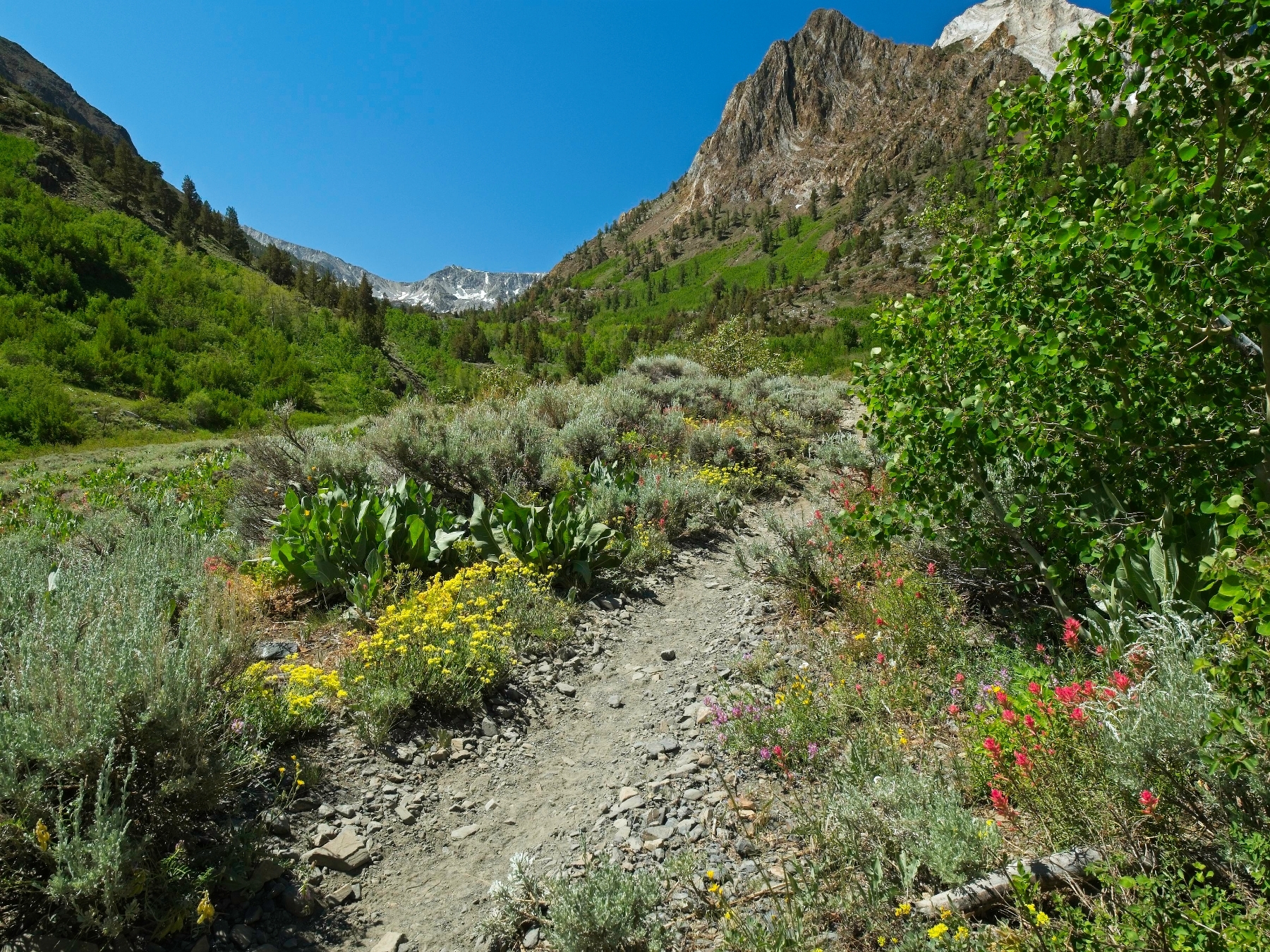
A few miles in the trail crosses McGee Creek. I don’t see a way to ford the rushing water without getting my feet wet, so I continue up the canyon on what appears to be a well-worn use trail, hoping to find a dry crossing. The trail soon returns to the creek, this time at a destroyed bridge. The carved log does span most of the creek, so I take off my shoes and socks, walk as far as I can on the old bridge, and then wade through the rest of the creek. Thankfully, the wind has died down a bit and the sun is out (for the moment, at least), so the frigid water isn’t too much of an additional chill.
Continuing up the canyon, now on the east side of McGee Creek, I stroll past one of the prettiest meadows I’ve ever seen. The creek winds through the soft grass in wide, lazy S-turns with a beaver lodge situated beside it. I stare for a while, hoping to see a beaver, and continue on after snapping a few photos.

Beyond the beaver meadow, the trail crosses McGee Creek again, this time on an intact bridge, and then climbs several hundred feet up a series of switchbacks. The open desert landscape of the lower canyon gives way to shaded forest with sunlight streaming through the trees. A couple of backpackers wave as I pass their campsite near the junction to Steelhead Lake; they’re the first people I’ve seen out here, which isn’t too surprising given the weather earlier today. But now the wind has died down to a gentle breeze with only the occasional gust and I can’t help but grin at the nearly perfect conditions.
The trail continues to climb, alternating between flat, leisurely strolls through the woods and moderately steep switchbacks to reach the next level of the terraced canyon. As you might expect, the scenery only gets prettier as I climb higher. I pass crystal clear ponds and stroll through green meadows full of shooting stars, mountain heath, and gurgling creeks.


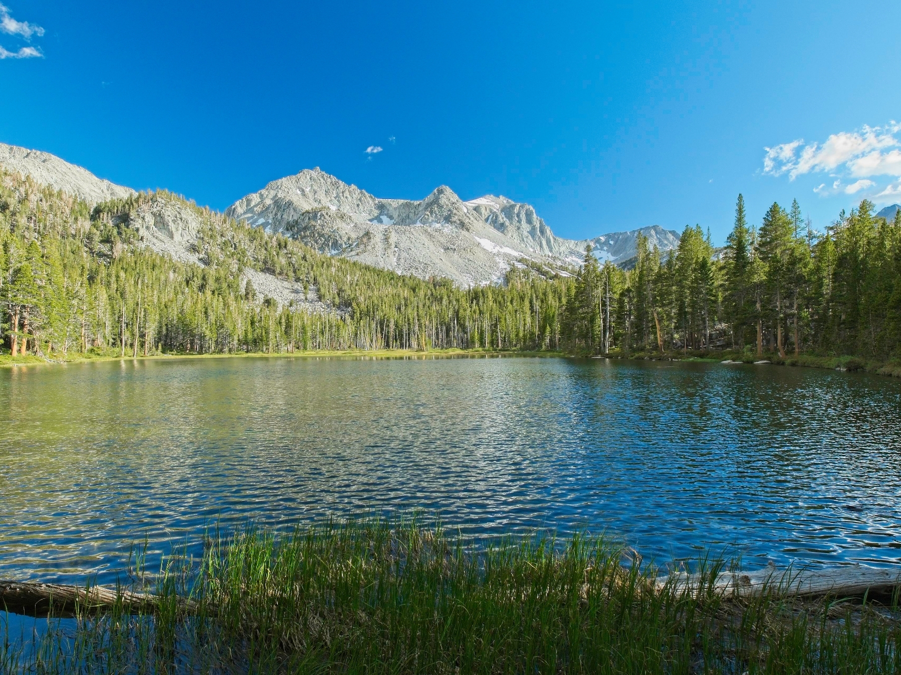
I’m all smiles as I reach Big McGee Lake. Situated just below tree line, there’s some wind blowing across the lake but it’s nowhere near as vicious as during the drive or beginning of the hike. I meet two groups of people at the lake, both with dogs. They hiked in this morning and got snowed on, so I’m glad I started a bit later! I set up my tent in a little clearing on the slope above the lake and then sit down to have dinner.


After eating, I study the map for a while and contemplate my plans for tomorrow. There’s a little more snow up here than I expected and I didn’t bring crampons, just microspikes and an ice axe. I’m comfortable on low-angle snow and ice with the spikes and axe, but I’m not keen on tackling any steep ice without crampons. My plan is to climb Red and White Mountain first, ascending to the ridge from Little McGee Lake. If that looks too steep, I’ll just continue up the trail to McGee Pass and head over to Mount Izaak Walton first and hit Red and White on the way back when the snow is softer. Satisfied that I have a workable plan, I put away the map, slide all the way into the warm the sleeping bag, and read The Parable of the Sower (Octavia Butler) until bed time.
Red & White Mountain and Mount Izaak Walton
Saturday, 18 June 2022 | 12 mi | +5200 / -5200 ft | View on Map
I slept well, completely cocooned in my sleeping bag and thermal liner. At about 5:30 I crawl out, retrieve my bear can full of food, and cook up some oatmeal for breakfast. After packing a day bag, I head up the trail toward Little McGee Lake, crunching through frozen mud on the trail. It doesn’t take long to reach the small lake; I stare up at the snowy slopes and look for a route to the ridge. There’s quite a bit of dry rock protruding from the snow, notably around the steepest slopes where microspikes won’t be very effective.
So I leave the trail and scramble down a short talus slope to a shallow, sun-cupped snowfield. After attaching the microspikes to my shoes, I set off across the icy snow, heading for the nearest island of rock. The hiking turns out to be pretty easy and I make quick progress up the slope toward the ridge. For the most part, I walk across the rocks without microspikes, occasionally crossing ten or twenty feet of snow. There are a few short, steeper sections where I use the ice axe to maintain extra grip on the snow, but it’s not really necessary for the climb.


The final hundred feet below the ridge are entirely snow covered, but it’s not very steep and I walk up easily enough with the microspikes. Peeking over the opposite side of the ridge, I find a sheer drop off, so I stick to the eastern side for the time being. There are a few tricky spots (class 3 at the most) but it’s mostly pretty easy scrambling. The snow actually proves useful as I’m able to wedge myself between the top of the snow bank (it’s about 3 feet deep up here) and the rocks and just walk forward.
Further along the ridge I clamber up onto the apex and continue to a saddle overlooking Big McGee Lake. The terrain flattens out a bit here and I proceed now on the western side of the ridge over class 2 talus. As I approach Red and White Mountain, my heart sinks; a steep snowfield completely covers the northeast ridge that provides access to the summit. If it’s as icy as the snow above Little McGee Lake, and I have no reason to think it’s not, it’ll be a real challenge to climb safely. I keep going regardless; it may turn out to be less steep than it appears or there might be a way around the snow. The only way to find out is to climb over there and get a closer look.
As it turns out, the snowfield is both shallower than I first thought and also avoidable! I’m able to climb up the talus beside the snow to the northeast ridge of Red and White Mountain where I find a mostly snow-free route over to the summit block. The ridge is also much wider than it appeared from a quarter mile away, so even the few patches of snow that cover the ridge top are easy enough to stroll across without fear of falling.

 - I'm not sure if I can make it through or around the snow up there")


On my way over to the summit block, I hear voices echoing off of the rocks. After some searching, I spot two climbers not too far behind me making their way toward the peak. I head up the final few hundred feet next. It’s not particularly difficult climbing (easy class 3), but the slate is a little loose. Slate is much sharper than granite, so I take care to test the hand- and foot-holds for stability before trusting my weight to them. Near the very top of the mountain I find a small bunch of sky pilots and can’t resist snapping a photo of them with snowy peaks as a backdrop.


Just a few steps more and I’m standing on top of Red and White Mountain! I rifle through the summit register, finding a bunch of names I recognize from other peaks. The two climbers behind me arrive about ten minutes later, and we chat for a while. They’ve hiked all the way up from the trailhead this morning, so they must have gotten an early start because it’s only 10:15!
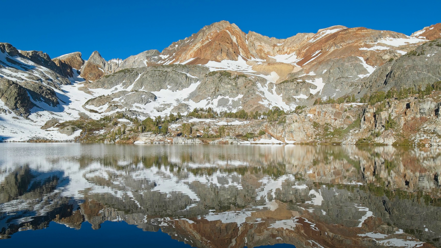
After exchanging some stories with the other hikers, I say goodbye and scramble back down the loose slate to the northeast ridge of Red and White Mountain. The snow tempts me to glissade and I even scramble down to see how soft it is but decide it’s too steep and too icy for my comfort level. Instead of sliding, I scramble back along the talus that borders the snowfield, descending toward Red and White Lake some 1500 feet below. It’s pretty easy hiking in general with a few tricky route-finding spots to avoid frozen cascades that haven’t thawed out yet. Further down the canyon I enjoy walking down grassy slopes and then across a wide, flat snow field all the way to the shore of the lake.


A pleasant, flat traverse around the north side of the lake brings me to the snow-covered outlet. I cross the snow bridge, contouring around the point of a rocky peninsula with awesome views of the Tully Lake basin below. My ice axe finally earns its keep on a short but steep scramble up a 20-foot snow bank between rocky islands, but I don’t need it again for a while as I hike cross country down a series of sandy, tree-filled benches. Rather than trying to remain at a consistent altitude, I descend toward the wide-open valley below, enjoying some easy class 3 climbing on classic Sierra granite.

As I cross the basin, the wind picks up some significant speed and I stop to pull on a jacket. I’m hopeful that it won’t persist; maybe the terrain is just funneling it through here? Ahead of me, several hundred feet of snow guard the ascent to the ridge above Rohn Pass. Before tackling that challenge, I find a rock to hide from the wind behind and eat lunch. I didn’t realized how hungry I was until I sit down and start eating. I’m glad I brought plenty of snacks today!
I don’t enjoy the climb up to Rohn Pass at all, but that’s mostly my fault for choosing a direct line instead of a more round-about but snow-free route. The first couple hundred feet are ok; it’s not too steep and the soft snow makes for easy climbing, but it’s melting and I can feel my feet getting wet. The final hundred feet of snow are steeper and the consistency alternates unpredictably between slippery, soft, mashed potatoes and slippery patches of ice. I rely on the ice axe several times and am glad to reach dry granite slabs at the top of the ridge.
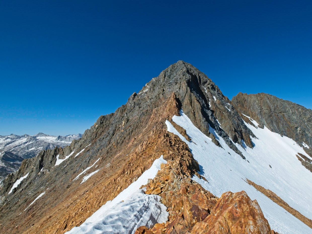
From Rohn Pass I’m treated to a great view of Mount Izaak Walton. The northeast ridge looks pretty gnarly with lots of massive boulders and slabs! I traverse down class 3 terrain to the saddle at the base of the northeast ridge, cross a small snowfield, and then begin up the ridge. The climb starts out with some straightforward class 2 terrain, gradually increasing in difficulty and exposure as I climb higher. I try to stick to the ridge proper, but I’m forced to descend to one side or the other more than once by sheer drop-offs. Maybe I’m not picking the easiest route, because some of the climbing is solidly in class 4 territory for me! It’s fun and mildly terrifying, as all the best mountains are.


I’m on the top of Izaak Walton at about 2 PM and take a long, relaxing break there. The views are spectacular in almost every direction. Red Slate Mountain and Red and White Mountain dominate the view to the northeast with the snowy Silver Divide stretching out to the west. I munch on snacks and peruse the summit log for a while, finding more familiar names before adding my own.
Rather than retrace my steps down the tricky (and exposed) class 3-4 ridge, I descend about 100 feet from the summit directly east through a sandy chute. Stringing together a series of benches and ledges is pretty easy and never exceeds class 3, so I don’t return to the ridge on the way back to the saddle. I also choose an easier path from the saddle to Rohn Pass – it’s amazing how a good view from a high vantage point (i.e., Mount Izaak Walton) can reveal the easiest routes through complex terrain.

In a continued effort to make my life as easy as possible, I locate the shortest possible snowfield leading down from Rohn Pass and then stroll through the lake basin on dry ground. Choruses of croaking frogs sing from several of the ponds, adding some much-appreciated tranquility to the afternoon. Puffy cumulus clouds race across the sky and I wonder if it’s going to rain or snow.
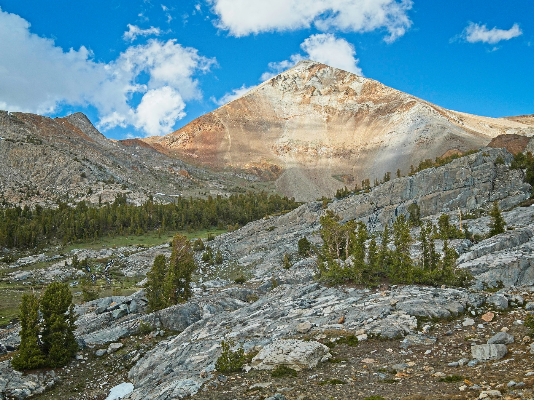
I enjoy the cross-country walk between the many lakes and creeks. Red Slate Mountain towers over the entire valley, drawing the eye with its contrasting red and white rocks and with its sheer size. My original plan for today was to climb to the summit on the way back; I’m heading up the trail to McGee Pass and the path from the pass to the summit is a straightforward, class 1 hike. But I’m getting pretty tired, my snack supply is running low, and I’m a little worried about the potential for afternoon thunderstorms with all the clouds.
As I struggle up the switchbacks to McGee Pass, my decision to skip Red Slate Mountain solidifies. A few short bursts of light snow and hail further convince me to hurry back to camp. But the plan to climb Red Slate doesn’t truly die until I reach the pass and look up at the 1200-foot sandy climb to the summit and the solid mile of snow between me and camp. I don’t have the energy to tackle both. Plus it’s already 5:30 PM and I’m increasingly hungry and cold.


So I abandon Red Slate Mountain and begin the descent from McGee Pass to Big McGee Lake. I enjoy a few dry switchbacks and then transition onto the snow with the help of my trusty microspikes. The trail soon disappears completely beneath the snow, but it doesn’t really matter where it is. The way forward is clear: walk down the canyon.
Thankfully, the snow is shallow and soft and I feel secure stepping between sun cups. I’m lucky that the terrain is as mellow as it is. This pass could easily include steep, icy snow, and I didn’t even think to check the conditions when I was planning! I was so focused on the technical portions of the day that I just assumed the established trail would be passable without any technical gear. Lesson learned. After what feels like an eternity (in reality, 30 minutes), I reach dry trail once again just above Little McGee Lake. I happily take off the microspikes and walk tiredly down the trail to camp.
When I reach Big McGee Lake I’m surprised to find that both groups camped here last night have left and nobody new has replaced them. Today is Saturday and Monday is a federal holiday (Juneteenth), so I expected lots of people to be out! Maybe the clouds and high wind forecast has scared people away? In any case, I’m alone at the lake tonight. I happily retrieve the bear canister and enjoy a hot meal before spending the rest of the evening relaxing in the warm tent.
Mount Stanford and Mount Morgan
Sunday, 19 June 2022 | 10.9 mi | +4200 / -4900 ft | View on Map
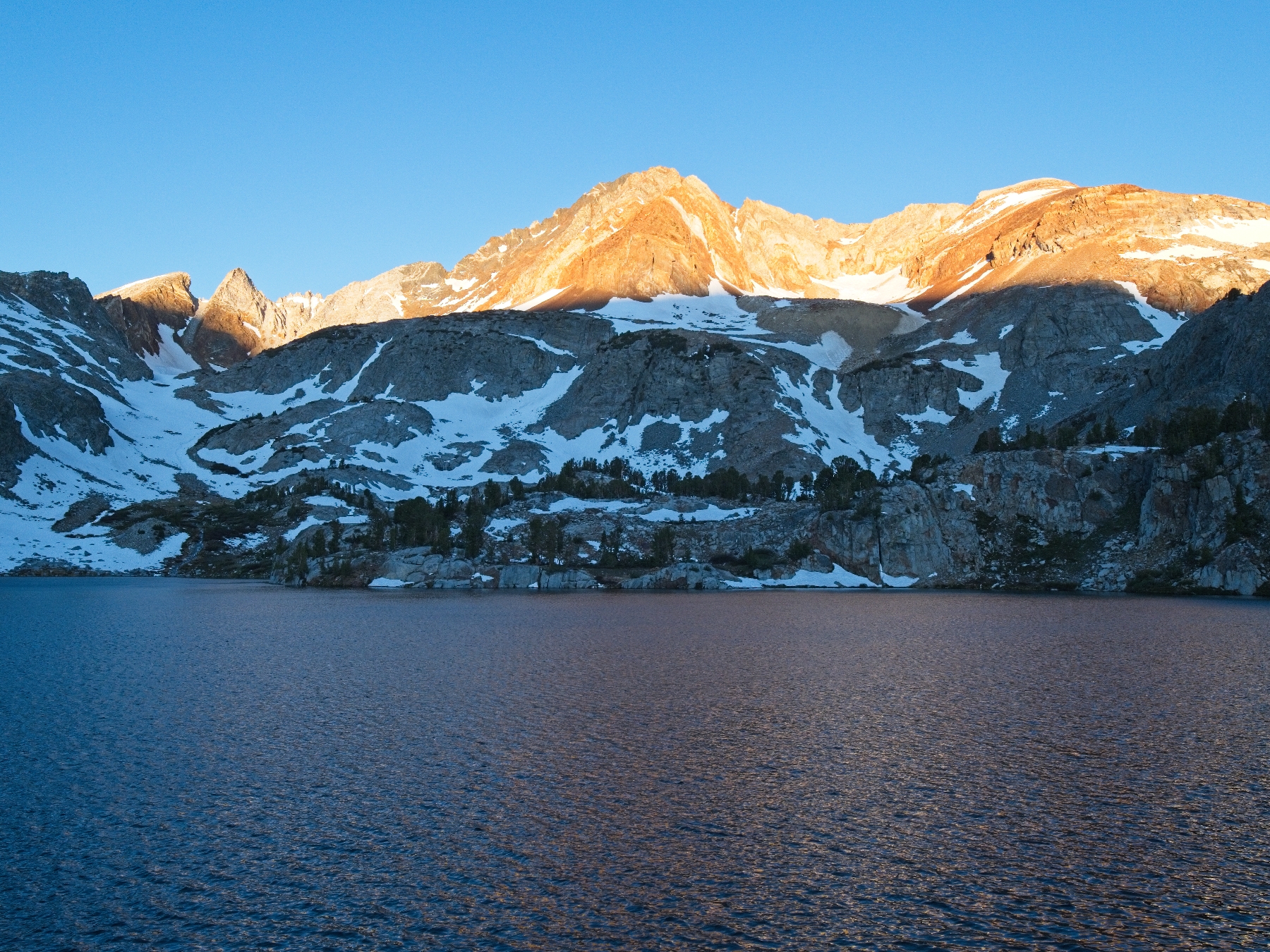
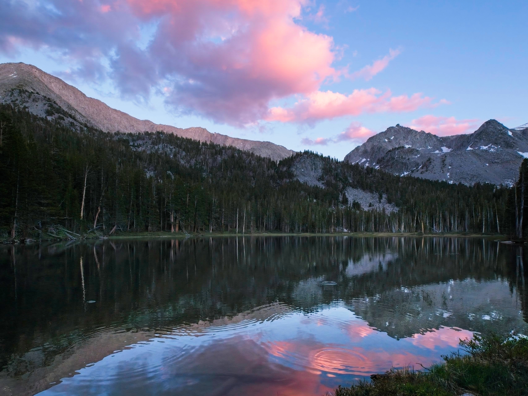
When I wake up the next morning shortly after 5 AM and step out of the tent I’m excited to discover that the wind is completely gone. Big McGee Lake is smooth as glass, so I grab my camera and sit by the shore for a while and watch the sun light up the mountains. Hunger pulls me away from the water eventually, and I do have a full day planned so I want to get going. I’ll move camp down to Grass Lake and then I’m heading up to climb Mount Stanford and Mount Morgan!
I’m on the trail by 7 AM. I pass all kinds of beautiful wildflowers and several large patches of “needle ice,” beautiful filaments of ice that extrude themselves from the damp soil in freezing temperatures. Despite the early hour and complete lack of other humans, I don’t spot any large animals in the alpine meadows below Big McGee Lake. I was hoping to see at least a few deer, but no such luck today.

 in a beam of sunlight")
")
On the way down the canyon I spot a few tents nestled into the woods but their occupants are nowhere to be seen; still sleeping, probably. To reach Grass Lake, I have to cross McGee Creek and that proves challenging. I’m not sure if there’s an easier crossing later in the season, but this morning I can find only one round-about sequence of rocks that will get me to the other side without wading. The real challenge is that some of the rocks are completely covered in a thin, invisible film of ice. The only sure way to tell is to stick out a foot or trekking pole and feel it out.
I make it across the creek after a few dicey foot placements and then climb a series of switchbacks up to Grass Lake. With a name like “Grass Lake,” I’m a little worried that it will be more of a meadow than a lake but I’m pleasantly surprised to find a sizable body of water. Like Big McGee Lake, I can’t see a single camper up here, so I have my pick of campsites. It doesn’t take me long to pitch the tent and throw my overnight gear inside.
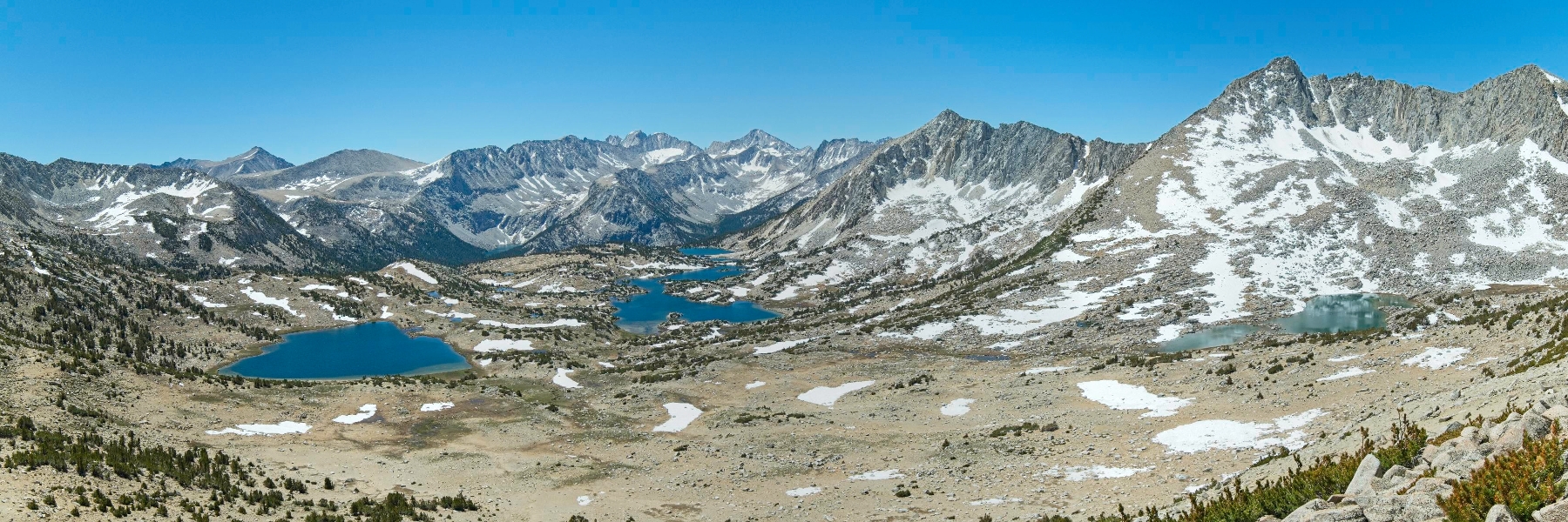
At 9:00 I begin the hike up to Mount Stanford. A nice trail leads to Steelhead Lake (also devoid of people – where is everyone?), but from here on out I’ll be hiking cross country. The first challenge is a wall of talus, but it’s stable and easy enough to scramble up. The talus levels out for the next three quarters of a mile and I have fun rock-hopping through the barren terrain. Sierra columbines (pastel blue and pink) are just barely beginning to bloom, which is a strange juxtaposition to the endless rocks. I keep my eye out for a photo opportunity, but blossoms are few and mostly hidden underneath boulders.
Secor’s route description says to scramble up a chute that tops out about 300 feet above lowest point on the ridge. I’m not exactly sure which chute he’s talking about, but it doesn’t seem to matter much. They all look equally passable, loose, and horrible. Loose and horrible prove to be pretty accurate descriptions; I struggle my way up the crappy rock, bailing onto a rocky rib between chutes at the first opportunity. The rib only offers a little respite, however; it too is composed mostly of loose rock.


Thankfully, the ridge itself is pretty solid and offers some spectacular views, both looking back at Steelhead Lake and down into Pioneer Basin on the opposite side. After a brief rest, I begin hiking up the ridge toward the high point: Mount Stanford. I find that the easiest path is sticking to the top of the ridge. Attempts to “side-hill” through the soft sand on the south side of the ridge are tedious and exhausting. But my ridge-top path ends in a sheer cliff long before I reach Mount Stanford. I’m forced to descend down the south side of the ridge to go around it (the north side of the ridge drops hundreds of feet straight down) and I’m faced with a series of three or four ribs, one of my least favorite mountaineering problems. A few cairns guide the way, but they’re few and far between, so I scramble over to the next rib using my best judgement, hoping to find a passable route down the other side.
As luck would have it, my choices work out and I’m soon standing at the base of a chute that leads to the summit. I avoid most of the loose stuff in the center of the chute by scrambling along the solid walls on the side. Strong winds on the summit motivate me to locate the register quickly, but I can’t find it. I check all three nearby high points and see several USGS benchmarks, but no register. Maybe there isn’t one up here?
I’m ready for a lunch break but don’t want to sit in the cold wind, so I head down the ridge a little ways until I find a sheltered spot. I check the map and the route description while I eat. It looks like the rest of the day should be pretty straightforward, although Secor describes the ridge between Stanford and Morgan as class 3. It looks pretty mellow to me!

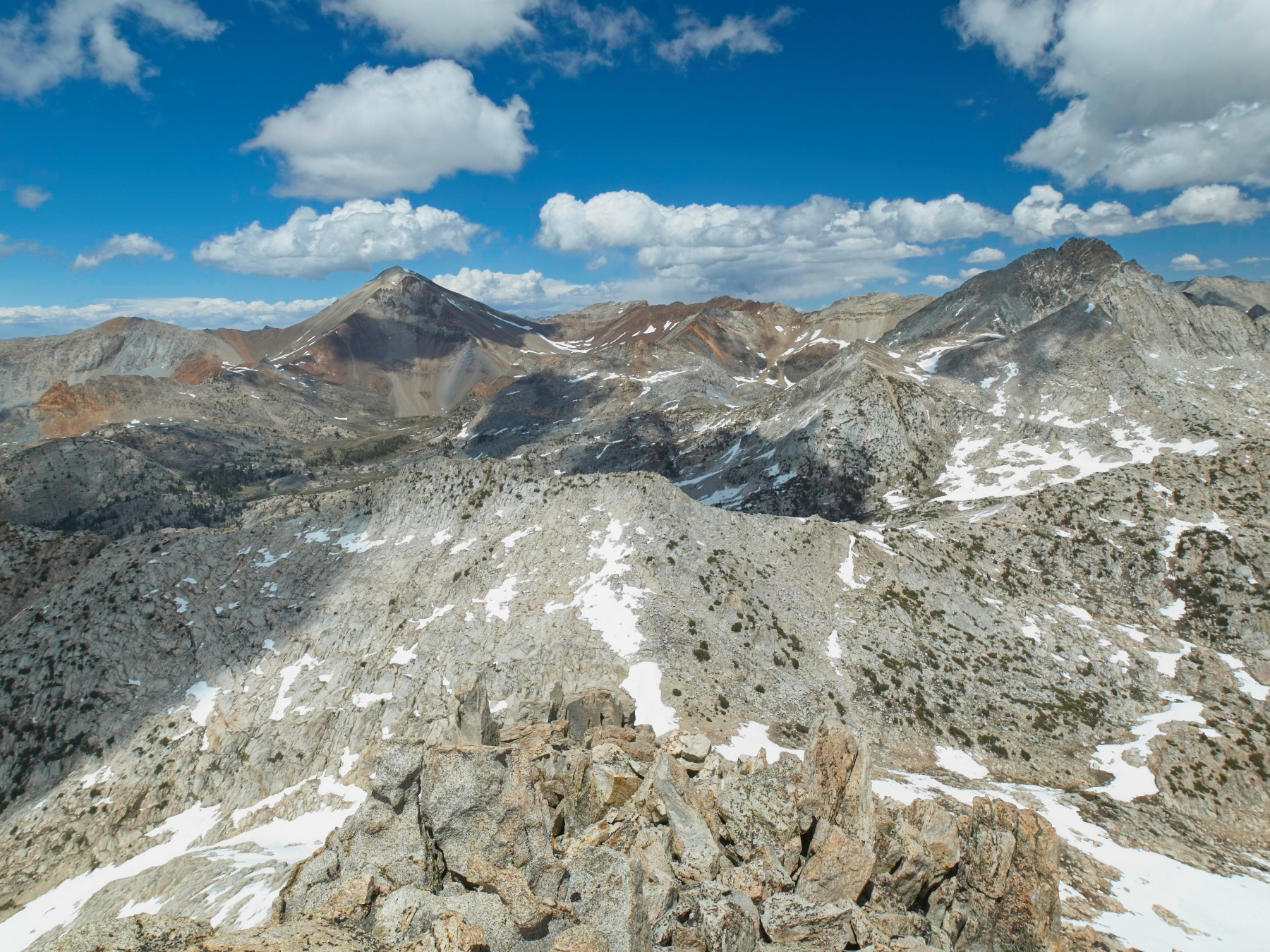
After lunch, I stroll along sandy, class 1-2 benches just below the ridgecrest, heading northeast toward Mount Morgan. It’s only when I turn a corner around a small sub-peak on the ridge that I see the challenging part of the ridge walk: several hundred feet of exposed class 3 climbing. Thankfully, the rock is pretty solid and I enjoy the climbing even though the airy ridge feels a bit precarious.


Beyond the technical climbing is an expansive, sandy plateau that leads to Mount Morgan. I half run down the sand to the plateau and then make quick work of the ascent to the summit. Despite its inconspicuous appearance, Mount Morgan offers some pretty amazing views. I can see all the way into Yosemite National Park!


The final challenge for the day is finding a way down to Grass Lake. Nearly all of the reports I read while researching this trip descend Mount Morgan to the east, but I need to go west to get back to my camp. So I’m following a GPS track from PeakBagger that descends a chute to gentler terrain; as much as I’ve tried to scope it out during the hike in and yesterday’s excursion to Red and White Mountain, I’m still not 100% sure about it.
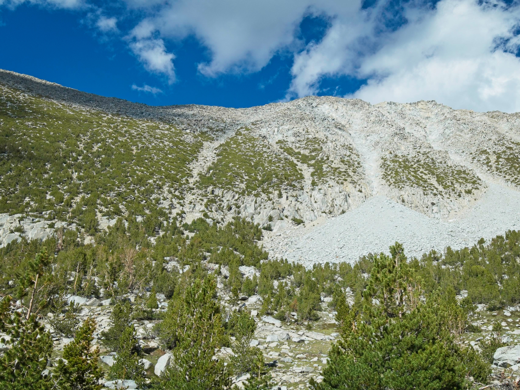
The first part of the descent is easy – I just walk back down the the sandy plateau and scramble through some boulders to a saddle northwest of Esha Peak. I’m nervous as I approach the ridge. What’s on the other side? Is it a sheer drop off? The topo map makes it look pretty steep! As soon as I get a glimpse of the terrain on the other side I’m able to relax. It’s not bad at all. An easy talus slope leads down to a sandy chute which in turn leads all the way down the mountain.
Foot-skiing through sand is always a fun way to descend a mountain, even when the sand is interspersed with small, rocky drop-offs. I see obvious signs that other hikers have passed this way and that gives me all the confidence I need to continue down the chute. The 1500-foot descent ends in a pile of rubble reminiscent of a terminal moraine, but I think in this case it’s all from rockfall. Once I’ve put a little distance between myself and the chute I turn back and snap a photo of the slope for future climbers to reference.
I enjoy the rest of the descent. For the most part, I get to stroll across a pleasant, wooded plateau. Game trails provide an easy path down the steeper slopes above Grass Lake and then I’m done with technical travel for the weekend! A few mosquitoes greet me as I walk past the outlet creek, but they’re not very persistent and I don’t bother putting on bug spray.
Back at the tent, a few hundred feet from the lake, I stretch out my muscles and then make dinner. It’s actually warm this evening, so I sit down in the sun with a book (still The Parable of the Sower) and read for a while. Once the sun dips below the mountains, I retreat to the tent and continue reading, but I keep an eye on the light so that I can get up to watch the sun set.
When the clouds begin to turn pink I stumble out of the tent and walk down to the lake. It’s a beautiful spot for a sunset! Little fish surface all over the lake, snatching bugs, but the water is otherwise calm and reflects the the colorful clouds. While I watch colors change, a solitary deer slowly emerges from the treeline on the far side of the lake – finally, some big wildlife! Once the light has faded from the sky, I head back to the tent and go to bed.
Leisurely Mountain Morning
Monday, 20 June 2022 | 5.1 mi | +100 / -2100 ft | View on Map
Today my only task is to hike back to the trailhead and then drive about an hour to Bishop. That’ll only take a few hours, so I enjoy a lazy morning. I don’t even wake up until 7 AM and spend the next hour reading, only getting out of my sleeping bag when the sun hits the tent. I eat breakfast in the sun, then pack up camp and begin the short hike out.
The rocks spanning McGee Creek aren’t covered in ice this morning, so the crossing is much easier than yesterday! I take plenty of photo breaks on the way down. In contrast to the hike in, the sun is shining today, highlighting the colorful wildflowers.
 are particularly pretty")
 beside the trail")
A little lower in the canyon I begin seeing day hikers and trail runners. Here are all the people! I spot a train of mules carrying supplies and people as well; I wonder how far they’re going? I don’t know how mules fare on snow, but I’m guessing they’re not going past Big McGee Lake.
The final mile or two of the hike pass through the wildflower-filled lower McGee Canyon. I snap lots of pictures along the way and chat with a few of the hikers heading up the canyon. At the trailhead I happily deposit my gear into trunk of the car and change out of my dirty hiking clothes into sandals, shorts, and a t-shirt. I’ve really enjoyed this weekend and can’t wait to visit this canyon again!