Originally, this weekend was supposed to take place in the Sierra Nevada Mountains, but forest closures and a series of wildfires made that difficult and a little hazardous. Thankfully, the coast has been relatively smoke-free so I threw together a plan to do some backpacking and road-trip sight-seeing near Big Sur. Kim and Carson joined me on this adventure and we had a great time!
Trip Planning
Specs: 23.5 mi | +/- 7000 ft | 3 days, 2 nights
Difficulty: Class 1 [learn more]
Location: Los Padres National Forest, CA | Home of the Esselen people | View on Map
Route: Begin at the Big Sur Station and follow the signs to the Pine Ridge Trail. Several detours avoid damaged portions of the trail – just follow the signs. The trail continues deep into the wilderness to Terrace Creek Campsite, then Barlow Flat, Sykes, and Redwood Campsites.
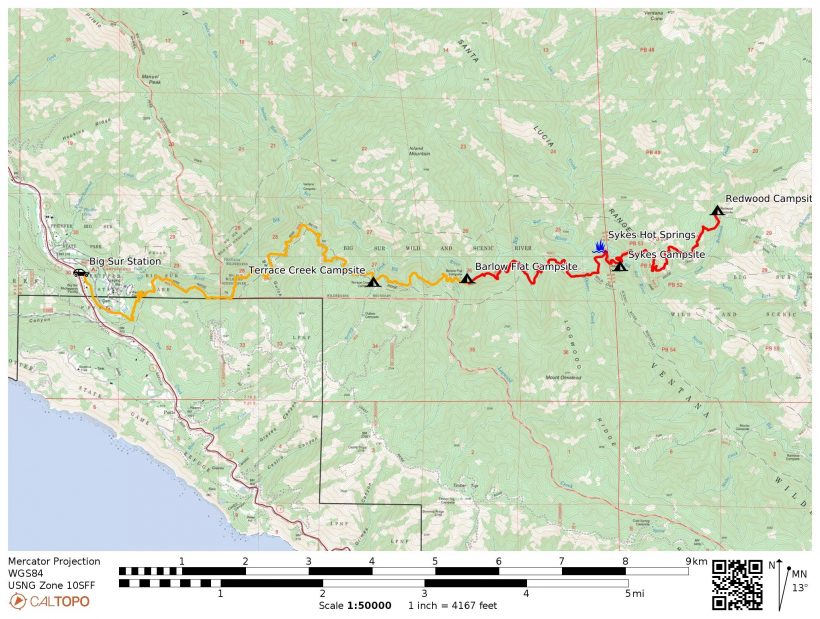
Permits & Regulations: Overnight trips from the Pine Ridge Trailhead do not require a permit, but you’ll need a campfire permit if you plan to use a stove or build a campfire. Parking at the trailhead costs $10 per calendar day. In the backcountry, bear canisters are not required (we hung our food) and there are pit latrines at each of the campsites (luxury!).
Resources: Stop by the Big Sur Station to ask the staff about current conditions. The Forest Service website for the Pine Creek Trail also includes lots of good information.
Ridge Roller Coaster
24 Sep, 2021 | 6.75 mi | +2600 / -1900 ft | View on Map
The drive up to Big Sur this morning didn’t offer many views. Low-hanging clouds obscured most of the mountains and the ocean, but cruising along the winding coastal highway in the fog was enjoyable in its own way.
After a tasty lunch, Carson, Kim, and I pull into the trailhead parking lot and are soon hiking down the Pine Ridge Trail. We pass through some frontcountry campsites and then begin a steep uphill climb into the wilderness. For better or worse, the sun is shining brightly as we struggle up the hill and I’m dripping sweat in no time.
 from the Pine Ridge Trail")

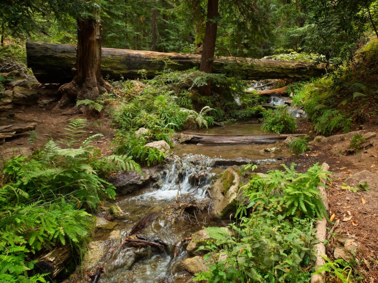
After the first big climb, the trail levels out a little but remains a bit of a roller coaster as it winds through gullies and over ridges. I’m intrigued by the variations in vegetation as we cross from one slope to another; some are only sparsely vegetated (and very hot!) while others support groves of massive trees and luscious undergrowth. As we continue along, Kim points out some Steller’s jays, a familiar, boisterous bird that also frequents the mountains around LA.
A few hours later, we descend a steep bit of trail to Barlow Flat, a gorgeous little valley beside the Big Sur River. We’ve covered a little less than 7 miles and that’s as far as we’re going today – it’ll soon be dark anyway. Several other people are camped nearby, but there are plenty of tent sites scattered around. We pick a spot close to the river and away from the other campers to avoid disturbing them. A soft layer of leaves and pine needles blanket the ground, the perfect surface for comfy camping. There are also lots of tiny black bugs around – on the leaves, logs, and soon on our packs and the tents. Although they look a little strange, they seem pretty harmless.
 are everywhere")

We spend the rest of the evening relaxing. This late in the season, night falls quite early (7 pm!) and we stay up talking the dark for several hours before finally calling it a night.
Redwood Camp and Sykes Hot Springs
25 Sep, 2021 | 10 mi | +/- 2500 ft | View on Map
The schedule for today is simple and leisurely compared to most of the backpacking trips I plan. We’ll grab some snacks and water and day-hike up the trail a few miles to see a grove of redwood trees, then meander back, stopping to soak in some hot springs on the way back. Today is all about relaxing outdoors, not crushing miles or climbing mountains.


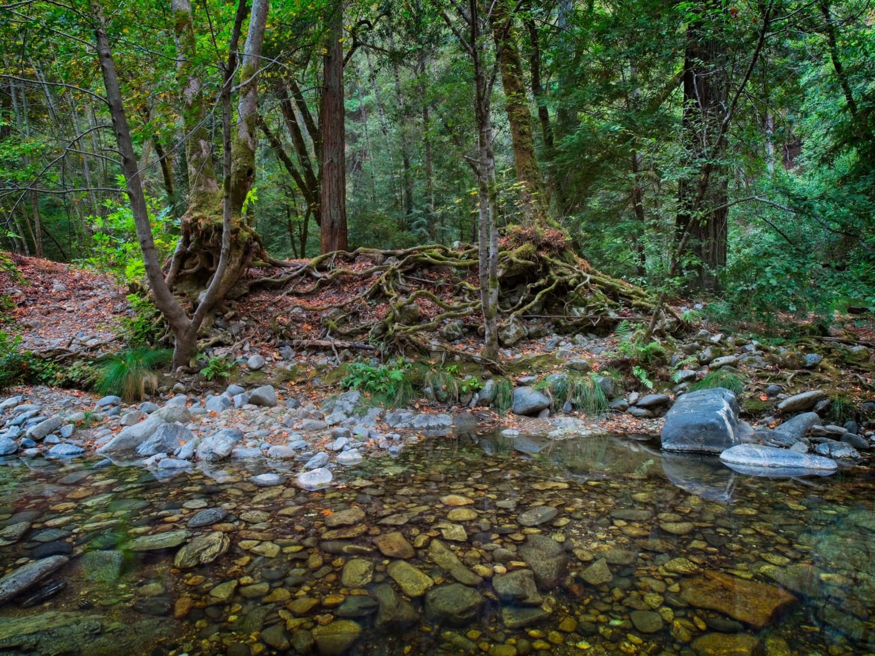
Although the hike today is fairly short (6 miles, one way), it’s not particularly easy! The trail climbs up hundreds of feet just to drop back down again more than once and much of the path is out in the sun. We reach the redwood grove a few hours after leaving camp and take a nice long break in the shade. The trees absolutely dwarf us! A persistent cloud of gnats and flies proves incredibly annoying, so we eventually head out, but only after refilling water bottles and munching on snacks.


I’m a bit surprised to discover that it’s downright hot on the trail back toward camp. Yesterday afternoon felt much cooler, and we’re only a few miles from the coast – where’s that cool, ocean air? A few sweaty miles later we reach the Sykes Campsite and abandon the Pine Ridge Trail, instead following a well-worn social trail downriver to the famous Sykes hot springs. We find several groups of people hanging out there when we arrive, but nobody is actually enjoying the hot springs so we hop in! The springs aren’t large – just two streams of hot water emerging from the river bank – but other hikers have built up little walls from rocks and sandbags that pool enough water to soak in.
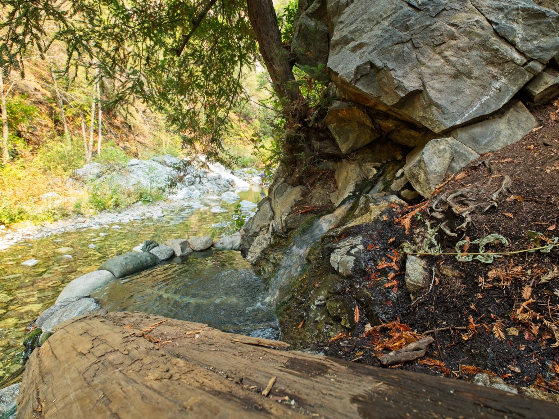
Kim, Carson, and I spend several hours at the springs. We don’t monopolize the hot water the entire time (it’s a popular attraction after all), switching to riverside seats after a little while. We chat with other hikers, most of whom are from the bay area, which makes sense given how far up the coast we are.
After a relaxing afternoon by the river, we trek back to the trail and then to Barlow Flat where our tents and food are waiting. I break out my stove for the first time this trip and cook up some ramen noodles for dinner. We stay up “late” (really just 10 pm, but 3 hours of complete darkness!) into the night again, talking until sleepiness comes.
Back to the Coast
26 Sep, 2021 | 10 mi | +1900 / -2600 ft | View on Map
In the morning, we hike back out to the trailhead. There’s a lot more uphill than I remember! We spot a few more birds along the way and (mostly) enjoy the multi-hour walk along the mountainside. We’re not in a huge rush, but I think everyone is excited for some fresh food and coastal views.


After changing clothes and refreshing ourselves a bit, we head down the road to Napanthe, a restaurant with supposedly awesome views. The prices are a bit steep, but there’s a cafe just down the hill with more appealing options and equally amazing views.
Once we’ve eaten, we continue down the coast, stopping at lots of pull-outs to snap pictures and gaze out at the precipitous coast line. It’s much sunnier today than it was when we drove up, so we’re afforded much better views! One of my favorite spots is McWay Falls, a picturesque waterfall that drops from pine-covered cliffs onto a sandy beach. McWay Falls is popular with everyone though, so the place is quite crowded.


My favorite stop, however, is much less obvious. We pull off the road next to a nondescript ladder that bridges over a barbed wire fence. Prickly heath stretches out for a hundred yards to the coastal cliffs with a narrow path meandering through it. At first, the path trends parallel to the coast, but we keep at it for a bit and are rewarded with a direct line to a rocky outcropping that offers incredible views of the heaving ocean below. I scramble around, snapping photos and changing lenses every five minutes – there are so many things to see! Carson, Kim, and I hang out there for a while, watching the waves crash over and swirl between the rocks.


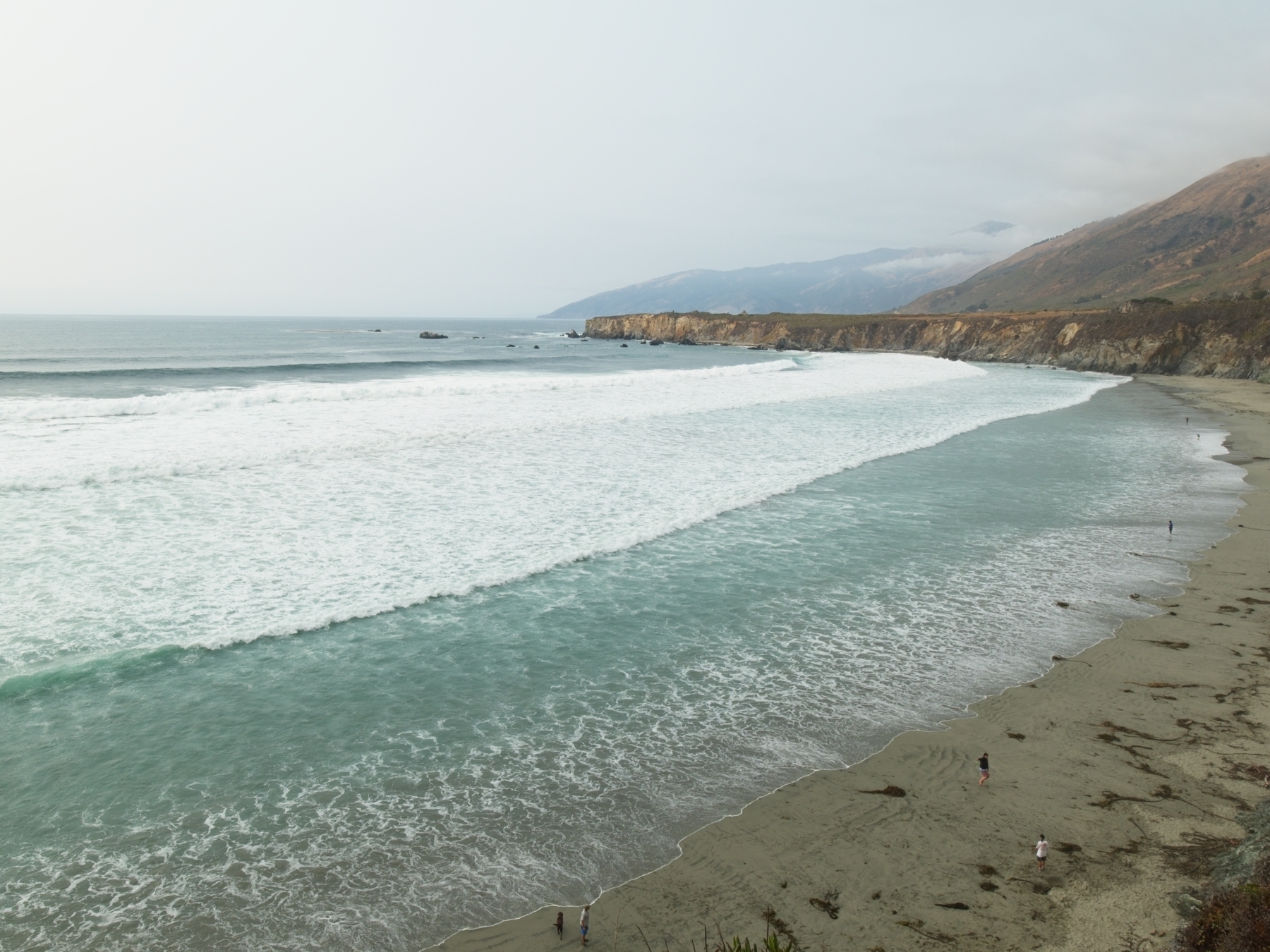
We eventually continue on, but not very far. Just a few miles down the coast, we visit Sand Dollar Beach and touch the Pacific for the first time this trip. It’s shockingly cold, much colder than the mountain creeks we crossed! Great clumps of seaweed lay scattered across the beach; their tough, slimy skins feel artificial, like plastic. We hang out for a bit, enjoying the cold water. Kim digs up a few tiny crabs that immediately re-bury themselves in the sand. It would be nice to stay longer, but we have many hours of driving ahead of us and work tomorrow, so we soon hit the road again and leave Big Sur behind us.
Wayne Aune 21 September 2023
Thanks for such good information.. I understand trip to Barlow Flat. Then next you went to Sykes? What is confusing is I believe you said 6 miles one way? Thanks