Craig texted me on a Sunday to ask if I wanted to join him on a peak-bagging jaunt up George Creek the following weekend. Both Trojan Peak and Mount Barnard are up that way and on my to-do list but I spent a day or two debating. George Creek is known for being a very difficult route – there is no trail, the canyon is full of dense brush, and the route begins about 7500 feet below the peaks. But better to suffer through it with a friend, right? We drove up the next Saturday for one-and-a-half day trip.
Trip Planning
Specs: 13.8 mi | +/- 8000 ft | 1.5 days, 1 nights
Difficulty: Class 2 [ratings]. Steep snow (35 – 40 deg) and class 2 talus are the main technical challenges on this route, plus a few miles of rugged bushwhacking.
Location: Inyo National Forest, California | Home of the Tubatulabal, Eastern Mono/Monache, and Western Shoshone peoples | View on Map
Route: The first challenge is reaching the trailhead. The official directions tell you to follow Foothill Road from Independence, but we took a more direct route on one of several dirt roads that branch off from highway 395 near Manzanar. You eventually end up on forest road 34E401, which grows progressively more rugged. On this particular day, it was 2WD-passable until the last half mile and then required high clearance and 4WD.
From the trailhead, follow the old road into the canyon. It ends almost immediately and you’re stuck bushwhacking for a little while. Once you reach a wider, more open section of the canyon where the creek splits into a few forks with a sandy area in the middle, make your way over to the south side of the creek and follow the use trail up the canyon. This makeshift path remains on the south side of the creek all way up the canyon, though we were forced to cross to the north side and then immediately back to bypass a waterfall and a washed out stream bank.

From the forested plateau at 9000 feet, hike up the ridge, aiming for the obvious canyon to the west that leads to the plateau beneath Barnard Peak. There are myriad options to the summits surrounding the plateau; choose your own adventure! Secor notes that the traverse between Barnard and Trojan is easiest if you drop to about 13,200 feet on the east side of the ridge.
Permits & Regulations: Wilderness permits are required for overnight trips and campfires are forbidden above 10,400 feet. The usual eastern Sierra wilderness restrictions on food storage (bear-proof!) and such apply; see the George Creek Trailhead page for more information.
Resources: The George Creek Trailhead page is the primary resource for this area.
Bushwhacking Galore
11 May 2024 | 3.2 mi | +2500 / -0 ft | View on Map
Craig and I leave LA around 9 AM, reaching the “trailhead” around 1 PM. There’s not really a trail here, just a few hundred feet of an old road that disappears into the jungle-like George Creek canyon. There’s not even a sign to indicate that this is George Creek, no infrastructure whatsoever.
We start hiking about fifteen minutes after arriving and soon reach the end of the path. Craig has been up the canyon once before, in 2014, so I follow his lead. We cross the creek a couple of times, keeping our eyes peeled for a path, but don’t find anything. Patches of scorched trees mark the Georges Fire (2018) scar and make it a little easier to move up the canyon.


After 30 or 45 minutes and a half dozen creek crossings, we finally find a well-traveled use trail on the south side of the creek. We follow the path up and down steep slopes and through dense thickets until we reach a cliff and a waterfall. There’s no clearly safe way across the creek other than leaping across wet rocks, and that’s just asking for a nasty fall. So we accept wet feet and wade through the water to shallower slopes on the north side, crossing back to the south further upstream.


The use trail continues up the canyon and we’re forced to do a little more wading when we reach a washed out creek bank. However, beyond that crossing, we enjoy relatively easy travel, with relative being the key word. Thorny bushes constantly stab me and there are several steep, loose ascents and descents. But it isn’t bushwhacking. I’m actually relieved when we reach a half mile section of talus.


By the time we reach our campsite at 9000 feet, it’s 4:30 PM and I’m thoroughly tired. All things considered, climbing 2500 feet in a little over three miles isn’t that bad, but the rugged travel really wore me out. Craig and I pitch our tents and spend the rest of the evening relaxing. We make a fire once the sun drops below the mountains and eventually go to bed at hiker midnight (9 PM).


Trojan and Barnard
12 May 2024 | 10.6 mi | +5500 / -8000 ft | View on Map
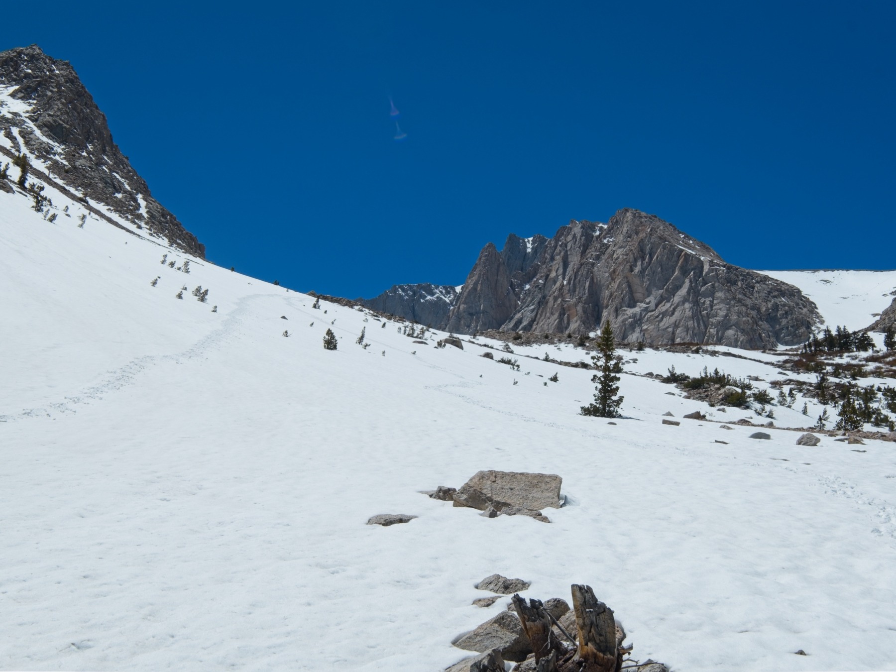
Craig and I leave camp at 5:00. It’s still dark enough for headlamps, but just barely. The eastern sky is already getting light, and we don’t need them for more than half an hour. From camp, we hike up a steep, brushy hill for a few hundred feet to much shallower terrain. Crunchy snow patches make for nice bridges through the manzanita and soon we reach the “high country” where the plants are few and far between. We continue up the snow in trail runners; it’s not steep or slippery enough for boots or crampons yet.


At about 6 AM, we reach a small alpine lake at 10,900 feet. I refill my water supplies and then meet Craig on the sunnier slope uphill of the lake. We’ll be climbing a much steeper snow-covered canyon next, so we take some time to put on boots and crampons, eat a snack, and slather on some sunscreen. The sun hasn’t warmed things up yet though and we’re both freezing, so we don’t waste too much time sitting around.


The chilly morning temperatures are more of a blessing than a curse. Hiking up snow is the easiest when it’s frozen solid. Our crampons grip the crusty surface without slipping and we gain altitude quickly. In a few hours this will all be slush; in a few weeks it will be horribly loose sand.
Craig and I reach the top of the canyon (12,200 ft) at 7:20 and take another short break. Craig will climb Mount Barnard East and I’m hiking in the opposite direction to climb Trojan Peak and Mount Barnard. My rough timeline for the day is: summit Trojan at 10 AM, summit Barnard at 12 PM, be back at camp at 3 PM, and be back at the car at 6 PM. We’re ahead of that schedule right now and I feel really good, so we’re off to a good start!


After agreeing to meet back at the alpine lake, Craig heads south to Barnard East and I begin hiking north to Trojan Peak. I cross a snowfield and then trudge up loose sand for several hundred feet to reach a snowfield that stretches all the way to the peak. I pause here to put crampons back on and swap out my trekking poles for an ice axe.
The slope soon steepens to 35 or 40 degrees, which feels precarious. Thankfully, the snow is still perfectly firm and my crampons don’t slip as I zig-zag between rocky outcroppings. During my many pauses to catch my breath, I look south and watch the dot that is Craig move up the snow.
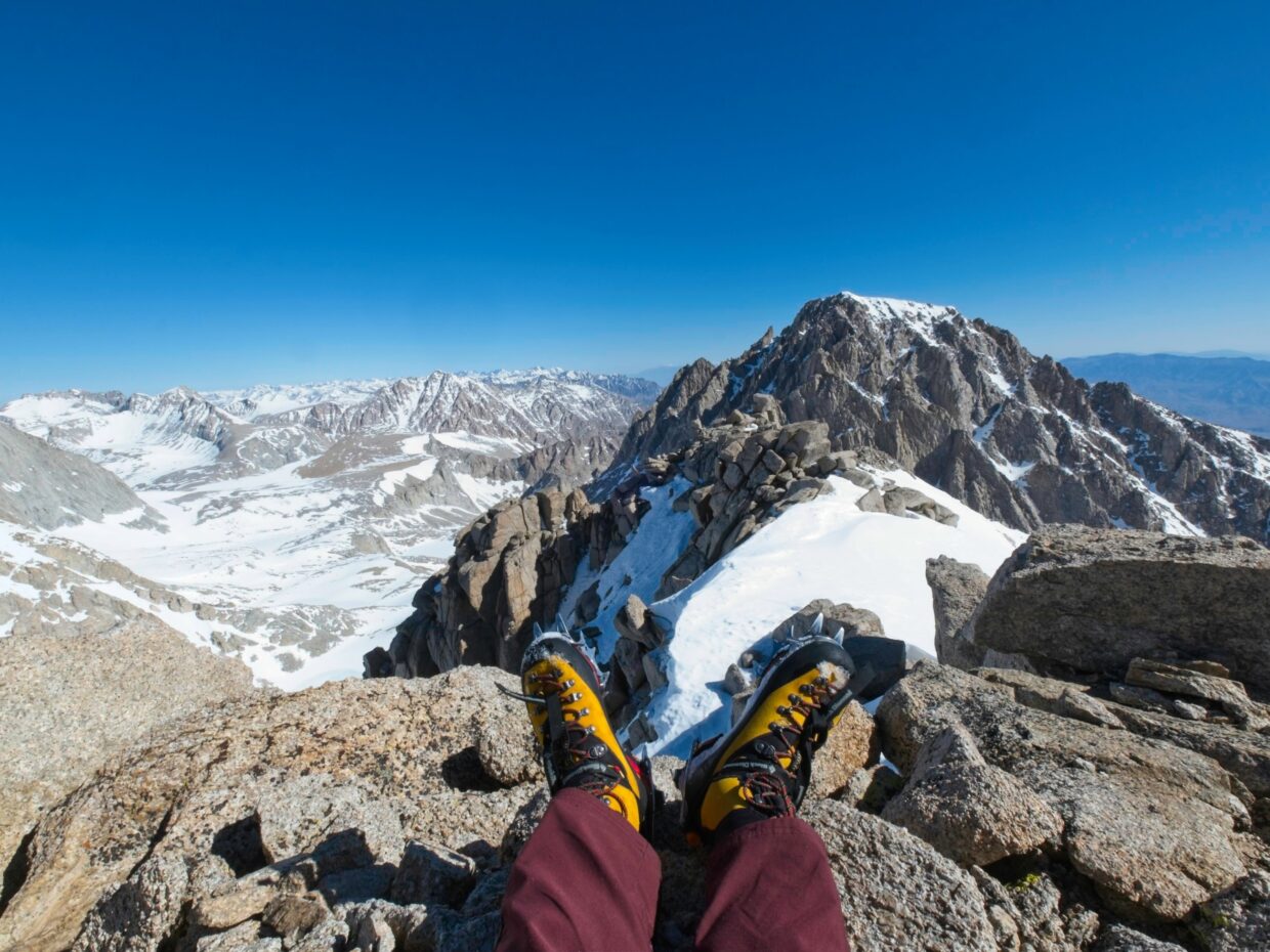
I reach the summit of Trojan Peak (13,947 ft) at 9:20. The wind-blown snow and half-buried rocks give the peak a rugged alpine feel, which I’m thoroughly enjoying. I have to chip the summit register out of the ice before I can sign my name in the book. Once I’ve logged my visit, I sit for a while, eat some snacks, and enjoy the view. Mount Williamson towers a few miles to the north, with razor-sharp Mount Tyndal across the basin. Turning around, Mount Whitney’s dramatic north face catches my eye. But my favorite view is the snowy plateau due west of Trojan Peak. A dozen frozen lakes and scattered trees surrounded by nearly continuous snow with jagged peaks behind it all… beautiful!


After relaxing for fifteen or twenty minutes, I begin down the southwest ridge of Trojan Peak. It’s mostly dry rock and shallow snow, so I pull off my crampons and hurry down the hill. Softening snow is my main concern; the route I want to take over to Mount Barnard crosses several thousand feet of snow on steep slopes and it will be no fun (and potentially dangerous) if the snow gets too soft. I debate trying to cross along the ridgetop because it looks mostly dry, but I know there are several deep notches that I would have to navigate around and I don’t want to waste time routefinding.
At 10:00, I drop down onto steeper snow (crampons back on) from a small saddle at 13,400 feet and descend a few hundred feet until I’m level with the highest continuous snow line I can see across the bowl. The snow is softening up very quickly and my feet slide around a little as I contour across the slope. I nervously keep an eye on the slopes above me and move as quickly as I can at 13,000+ feet. It’s not fast, but I’m across the snow (and past the large notches) in about an hour!


My path to the summit of Mount Barnard is completely free of snow, so I stash my crampons away and change back into trail runners. My feet are sweating in the mountaineering boots and I’ll be much faster in the lightweight shoes than in the heavy boots.
I stay close to the ridge on the way up, mostly to enjoy the exhilarating view. It only takes half an hour of talus scrambling to reach Mount Barnard’s summit at 13,990 ft; it’s 11:20 AM. I rest for a good twenty minutes up there, again admiring the views. I eat half of my lunch, sign the summit register (first entry of 2024!), and then begin the descent.


Thankfully, the talus slope from Mount Barnard into the valley below is neither very steep nor very loose. I move as quickly as I can without risking a twisted ankle or nasty fall. I’m soon down on flatter ground and speed across the rocks and snow. I reach the edge of the steeper snow at 12:30 and pause for a few minutes to put my boots back on. The snow is getting very soft now so I want the ankle support and water resistance; my trail runners would just end up soaked.
Once I’ve got the boots on I start down the slope. The top few inches of snow are slushy but it’s firm underneath, so I don’t posthole at all. I half run, half boot-ski down the hill – it’s very fun! A few roller balls race me down the hill, an early warning sign of a potential avalanche, but I don’t think it’s wet enough yet to slide. It only takes me twenty minutes to reach the lake where Craig is waiting. We speed down the rest of the snowfields in similar fashion and are back at camp by 1:35, a good 85 minutes earlier than I budgeted for.
I’m pretty tired, so I spend a few minutes sitting on a rock while finishing the other half of my lunch. As much as I’d like to take a nap, I’d rather get back to the car (and home) as soon as we can, so I pack up my things after a very brief rest.
We’re able to follow the use trail almost all the way back to the trailhead today. However, we completely loose the use trail near the bottom of the canyon. Between the forest fire, high water, and who knows what else, there just isn’t a reliable path here. So we whack through some brush, cross the creek a few more times, and arrive back at the car at 4:00. I’ve never been more happy to see a wide open desert.