During the second half of the American Alpine Institute’s “Alpinism II” course, my teammates Matt, Matt (a.k.a. Splat), and I planned a short trip to summit Sloan Peak. Elias, our guide and teacher, offered advice here and there but let us do most of the work; trip planning and leadership is part of the course. We planned to follow “The Corkscrew” route to the 7835-foot summit, named for the spiraling path around the massif. After this summer’s trip to Mount Baker, I was excited (and a little scared) to get back on a glacier and reach a new summit!
Trip Planning
Specs: 7.9 mi | +/- 4100 ft | 2 days, 1 night
Approach only; glacier travel and rock climbing not included. Could certainly be completed as a single-day trip
Difficulty: Class 1 hiking and technical glacier travel plus class 3 rock climbing [learn more]
Location: Mt. Baker-Snoqualmie National Forest; Henry M. Jackson Wilderness | Home of the Tulalip, Stillaguamish, and Coast Salish peoples| View on Map
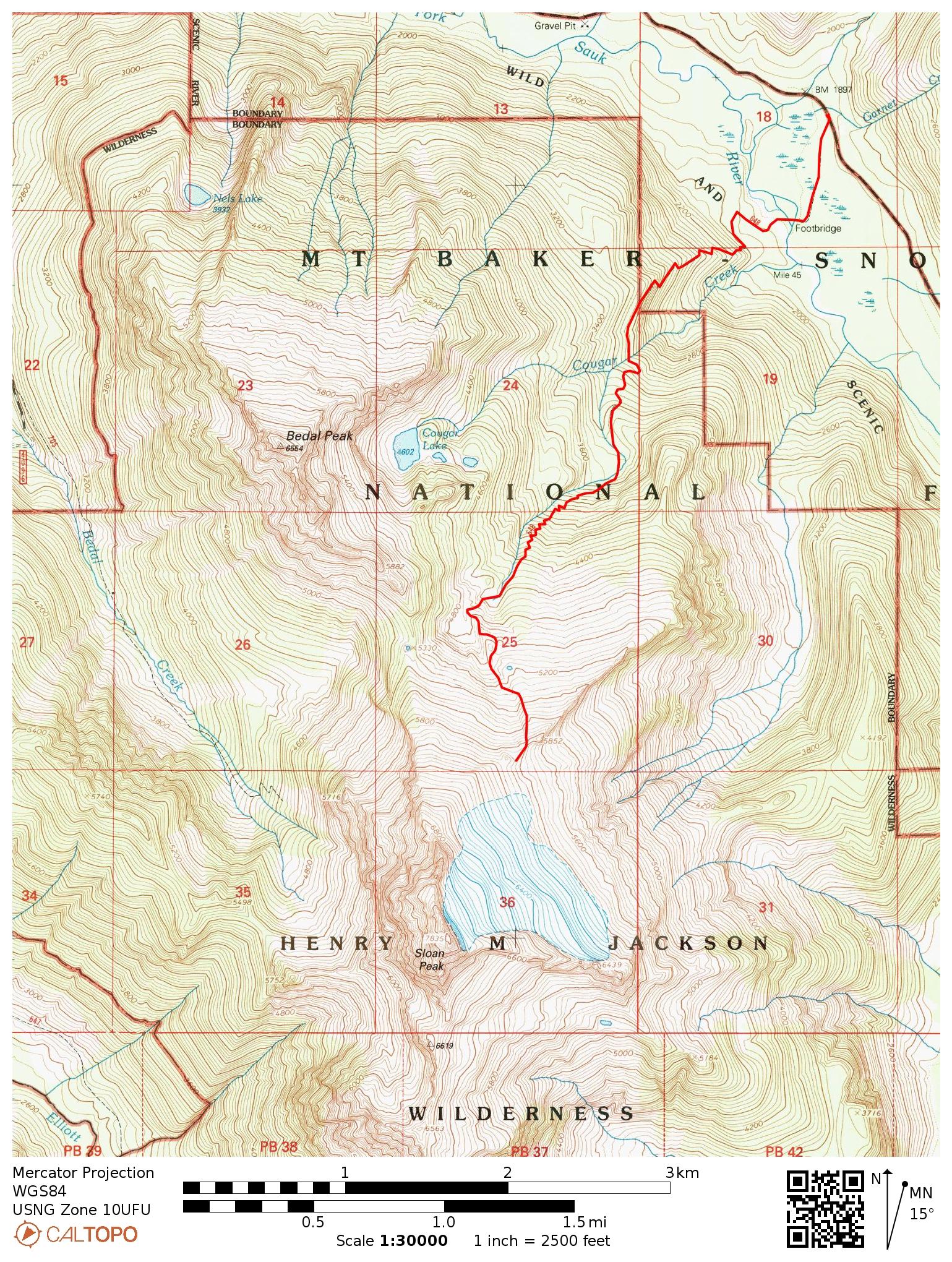
Route: Begin at the Sloan Peak Trailhead on the NF-49 road (limited parking available). The trail is clear and easy to follow for the first several hundred yards but becomes overgrown and quite difficult to follow at the first branch of the Sauk River. Follow the flags (they can be hard to spot) through the complex terrain around the river, crossing three distinct branches. Once past the river, the trail is once again easy to follow and climbs steeply toward the peak. The technical portion of the climb is not described here. Return via the same route.
Permits & Regulations: No permits are required to hike or camp in the national forest, but a Northwest Forest Pass is required to park at the trailhead. Standard national wilderness restrictions apply and you should (always) practice leave-no-trace principles.
Resources: I recommend printing out the USGS quads for the area surrounding Sloan Peak. The Gaia GPS app is also handy for interactive navigation. Make sure to visit the Mount Baker-Snoqualmie National Forest website for current conditions and alerts; the Sloan Peak Trailhead page is also a useful source of information. For more information on the technical portion of the climb, check out SummitPost or Beckey’s Cascade Alpine Guide.
Climbers Trail to Glacier’s Edge
7 August, 2020 | 3.95 mi | +4100 ft | View on Map
Matt, Splat, and I gather in the morning with Elias, our American Alpine Institute guide. Today we’re beginning our second objective of the Alpinism II course. Elias delegated the trip planning to us so we’ll be leading the way.
After tearing down our camp near the Sloan Peak Trailhead, we shoulder our packs and head into the dense, damp woods. It rained all night long and though it’s not raining anymore, every leaf and stem is covered in water droplets that shower onto our feet and legs as we stride through the brush.


A few hundred yards down the trail we reach the first of several branches of the North Fork of the Sauk River. The path veers to the left, parallelling the water for a while and passing several log jams along the way. The trip reports and guide books we reviewed during our planning sessions this week claim that “good log bridges” exist to cross the river. None of the log jams look particularly “good” to me though, and it’s not exactly an easy wade; the water is 3 – 4 feet deep and flowing pretty quickly.
We discuss options and finally choose a log jam to cross. Elias leads the way; Matt, Splat, and I follow him. Once on the other side we continue bushwhacking and reach another creek. Rather than spend time searching for more fallen logs we just wade through. Our pants and shoes are already soggy anyway, so what’s a bit more water?


Perhaps an hour later we emerge from the jungle onto the vast, sandy banks on the far side of the river. A series of pink ribbons tied to trees and fallen logs lead us to the trail. After a short but enjoyable walk we reach an old, overgrown railroad grade where we sit down for a break. I squeeze excess water out of my shoes and socks and munch on a snack, grateful to be back on an established trail.


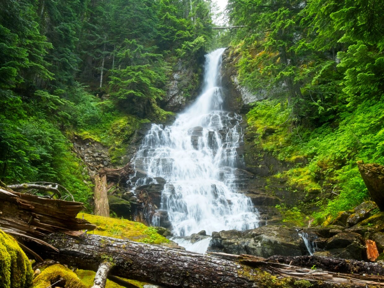
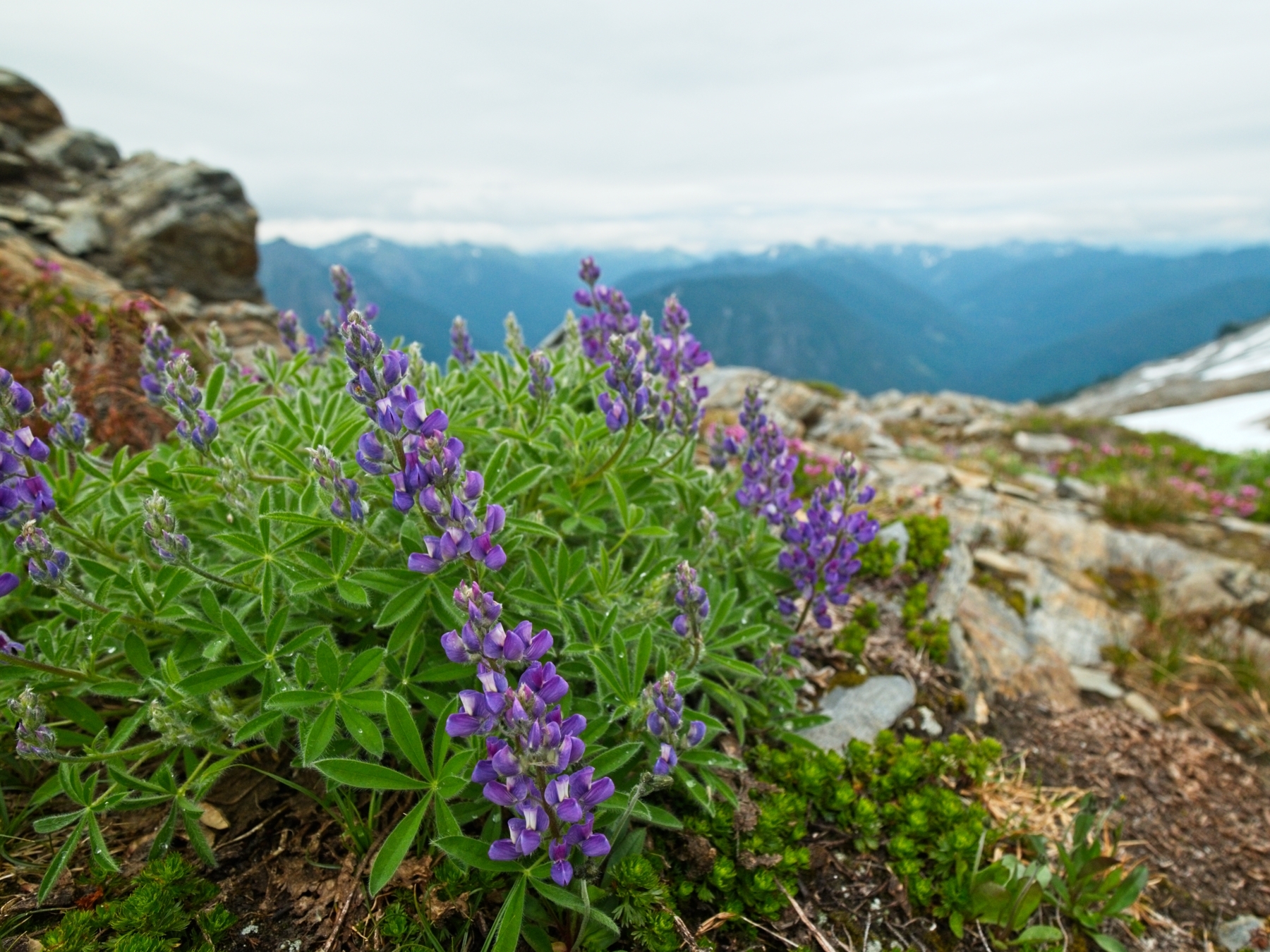
The next several miles prove to be wet, steep, and difficult. The climbers trail leaves the shallow railroad grade almost immediately, opting instead for a calf-burning straight-up-the-mountain route. The narrow path also puts us in continuous contact with dew-covered plants, drenching our pants and shoes. If soggy clothing and the steep trail aren’t difficult enough, we’re frequently confronted with massive, fallen trees that are a real struggle to clamber over. But the hike isn’t all misery. We pass an incredible waterfall and see a baby black bear in a meadow below the trail! Higher up the mountain, we leave the forest (and most of the wet plants) behind and walk through wildflowers with sweeping views of the surrounding mountains.


The final few hundred yards of our approach is the steepest part of the hike, but we soon reach a long, rocky ridge where we’ll camp for the night. The first order of business is figuring out our schedule for the summit bid. We’re constrained by the time we need to be back in town tomorrow and by sunrise; there’s a glacier to cross and none of us have seen it (well, Elias has crossed it before, but it is up to us to lead the way) so we’ll need daylight to navigate it safely. That’s doesn’t leave us very much time, so we decide to try to blaze part of the trail tonight. Elias and I will head out onto the glacier while Matt and Splat, who are a bit rusty on crevasse rescue, practice their skills. If everything goes according to plan, we’ll have a boot track to follow in the morning, allowing us to do part of the trek in the dark, and we’ll all be caught up on the necessary skills.


Elias and I gear up for glacier travel and head out onto the snow. I’m more than a little nervous to be out on an unknown glacier on a two-person rope team. If Elias, who is leading, falls into a crevasse, it’s 100% my responsibility to arrest his fall and make sure he gets out. We move cautiously across the glacier; Elias describes the signs he sees and how he interprets them to choose our path, teaching me as we walk.
About an hour into our scouting mission, clouds move in and obscure the most complex part of the glacier that we have been working toward. Plans thwarted, we turn around and return to camp. Elias and I eat dinner and review skills with Matt and Splat for a while. It soon becomes clear that we’re not prepared as a team for the glacier traverse and a light drizzle begins to fall (how’s that for pathetic fallacy?). Elias makes the difficult call to abandon tomorrow’s summit bit. Instead, we’ll do a “glacier tour” to get out on the challenging terrain and continue learning without the time pressure of racing to the summit. On the bright side, there’s no longer any need to get up before sunrise!
Soggy Retreat
8 August, 2020 | 3.95 mi | -4100 ft | View on Map
When I wake up in the morning and peek my head out the tent door the mountain is completely shrouded in mist. Dew and rain have completely soaked the tent, but thankfully my sleeping bag is still relatively dry. With the low visibility and continued drizzle, we abandon the plan to explore the glacier and instead do some skills practice on the snowy slopes below.
After a few hours of practicing self-arrest and crevasse rescue, we pack up our soaking wet tents and begin the hike back to the trailhead. Each of us slips and fall at least a couple of times on the steep trail, but we all make it back to the river without injury. Now that we know to look for flags in the dense foliage, we manage to pick a more direct line across the three coursing waterways than we followed yesterday.
Back at the car, I change into wonderfully dry clothes and toss my soggy gear into the trunk. Although I’m a little disappointed that we weren’t able to make a summit attempt, I’m mostly just glad to be warm and dry. There will be plenty more opportunities to climb mountains; it’s not worth taking unnecessary risks to justify a long, difficult hike. Elias, Matt, Splat and I climb into our respective cars and pull away, leaving the Sloan Peak Trailhead in the rear view mirror.
Carlos M. Bowman 31 January 2021
Wise choices!