I had a ton of fun hiking the first 26 miles of Steve Roper’s Sierra High Route in early July and decided to return to complete the rest of the trek. Rather than re-hike the first 26 miles, I began this trip at Baxter Pass on the east side of the range and hiked a few miles up the John Muir Trail to Upper Basin, the last point on the High Route I reached previously. From Upper Basin, I followed the Sierra High Route (SHR) northward.
This post includes the last few miles of the first Sierra High Route section which Roper names “Cirque Country” and is labeled “Cirque (2)”; additional posts detail my journey along the rest of the high route.
Trip Planning
Specs: 114.6 mi | +35,300 / -33,800 ft | 8 days, 8 nights
Difficulty: Mostly class 1 but includes a significant amount of class 2 scrambling and the occasional class 3 section [learn more]
Location: Inyo National Forest, Kings Canyon National Park | View on Map
Route – Begin at the Baxter Pass trailhead and hike over the pass, down to Baxter Lakes. From the lakes, follow a faint trail to reach the John Muir Trail and/or Pacific Crest Trail. Continue northbound on the JMT/PCT to Upper Basin, i.e., the valley just south of Mather Pass. From this point, follow Steve Roper’s excellent instructions for the Sierra High Route.
Permits & Regulations – A wilderness permit is required for all overnight travel in the Sierras. Since the entry trailhead is located in Inyo National Forest, you’ll apply for a permit through the forest service at Recreation.gov. Baxter Pass doesn’t seem to be a terribly popular trailhead, so you shouldn’t have much difficulty securing a permit. Additionally, remember to leave no trace; it is your responsibility to preserve the wilderness for others to enjoy.
Logistics – The Baxter Pass Trailhead is located about 8 miles from Independence. Since it isn’t a popular trailhead, hitchhiking to and from this starting point is quite difficult. Rather than try to get a hitch or walk the 8 miles through the desert, I booked a seat on the Eastern Sierra Shuttle Service. However, they charge a staggering $55 for the 20-minute ride; not exactly an economical option, but the only local shuttle service at the time of writing.
Resources – Steve Roper’s book, The Sierra High Route, is a crucial resource to navigate the off-trail portions of this route. I augmented his instructions with the excellent National Geographic topo map for the Sequoia-Kings Canyon area. Alternatively, you may find my interactive map of the Sierra High Route useful for your own planning purposes.
Baxter Pass Entry
31 July 2018 | 12.8 mi | +6500 / -4000 ft | View on Map
I arrive at the trailhead at about 9:30 AM, far later than I would prefer, but certainly early enough to get some hiking done! The sun beats down on the arid desert landscape as the shuttle driver turns his car around and rumbles off down the dusty dirt road toward civilization. Soon, I’m alone with nothing but a fully-loaded pack and the trail in front of me. I might as well start walking!
Securing a permit for the Baxter Pass trail proved much easier than other trailheads, and I soon realize why: This is not an easy, scenic, or pleasant path. I struggle over loose stones and slip on stretches of gravel, all the while being poked and prodded by various prickly desert plants. As I pass by the creek, I brush a stinging nettle plant. To my surprise, the velvety barbs on the leaves easily penetrate my pants and shirt, sending stinging sensations rippling through my legs and arms. Frustrated and in pain, I continue up the trail, keeping watch for more nettles and using my trekking poles to push them away when possible.
As I huff and puff up the trail, the sun climbs higher and the day grows hotter. I’m soon dripping sweat, and there isn’t much shade to be had either. Judging by the abundance of charred tree trunks, it seems that a forest fire swept through sometime in the past decade and obliterated whatever forest existed. I take a few breaks to catch my breath and drink water, but I’ve noticed that the clouds overhead are beginning to coalesce into a solid sheet, and they’re getting darker. I’ve seen this behavior as recently as last weekend in Humphrey’s Basin; thunderstorms are likely on the way. While the climb is stupidly difficult, I press on so that I don’t get stuck on the top of Baxter Pass when the rain and/or lightning arrives.


Higher up the slope, I reach some trees that escaped the forest fire. The twisted junipers supply some shade, although the dark clouds are already blocking out most of the sunshine. The thin air is beginning to affect me; I’m forced to pause every few minutes to catch my breath and wait for the lactic acid in my legs to flush out. Soon, thunder begins to echo through the mountains. Still well below the pass, I sigh but keep walking until the rain begins. I take shelter in my tent for a few minutes, but the rain soon stops and I continue climbing toward the writhing clouds. A reasonable person would remain below treeline when storms threaten as they do now. I’m not one of those reasonable people, at least not today: I would rather risk the storm and get over the pass than wait it out for an untold number of hours and have to make up all those extra miles in the coming days.
The final mile to the pass really kicks my butt. Thankfully, the rain holds off and no lightning bolts strike the surrounding peaks. Now well above treeline, each step requires a concerted effort and I’m pausing at 20-foot intervals, legs on fire, gasping for air. Every once in a while a particularly violent thunder clap jolts me from the rhythm of trudging and motivates me to give a little more effort and speed up. Well, at least until I run out of oxygen again…
After what feels like an eternity, I reach the pass. A broken sign marks the saddle; I’m surprised to see that the elevation is over 12,300′! No wonder breathing is so difficult! And I’ve climbed well over 6000′ from the trailhead with a fully loaded pack. At least I feel slightly more justified in my suffering.


I snap a few photos but quickly continue on as several deafening thunderclaps echo around me. Half walking, half jogging, I speed down the slate-covered slopes toward one of several Baxter Lakes; a few trees line the banks and will provide some shelter from whatever excitement the clouds send my way.
Thankfully, the rain and lightning hold off as I descend through the barren, slate-filled bowl above the Baxter Lakes. By the time I reach the trees lining the shore of the highest lake, I’m ready for a break. I find a stand of trees to shelter me from the light drizzle that has begun to fall and lie down. I also pull off my shoes and socks to let my feet breathe a bit; shoes are great and all, but it sure does feel nice to take them off.
After resting for ten or fifteen minutes, I continue on; there is plenty of daylight left! The well-defined trail that leads from the pass to the lake soon fades into the long grass and scraggly trees. After losing the path a few times I give up trying to follow whatever faint traces I can find and instead rely on the map and compass to navigate. Although the trees make it difficult to quickly identify landmarks, a compass heading and the general layout of the local lakes and creeks is sufficient to guide me down the valley.
After passing the lowest lake, I descend slopes strewn with pine needles to a lush, marshy section of forest. The dew-covered plants drench my pants as I continue, and an inopportune step into a puddle masquerading as muddy soil soaks my right shoe completely. Ah well; the sun is beginning to break through the clouds, and it looks like I might get some warmth this evening! I soon rediscover the trail and follow it for a few tenths of a mile. However, upon discovering that it winds along the ridge for another mile in the opposite direction as my destination, I abandon the path and scramble directly down the steep slope towards the South Fork of Woods Creek. I struggle through a few layers of aspens and hop down the talus until I reach gentler wooded slopes and, further down, the South Fork of the Kings River. The South Forks proves easy to cross, and I soon find myself standing on the John Muir Trail.
The final few miles of the day pass quickly and easily; it’s amazing how easy walking on a trail feels after struggling over unmanicured terrain. To further improve my mood, the clouds melt away and sunshine warms the world. It also helps that I get to walk along a gentle downhill trail all evening.
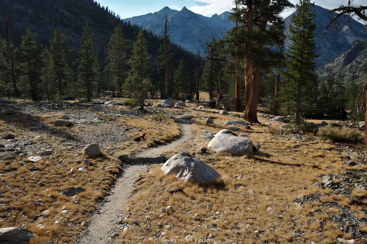
A few miles along the JMT, I reach Woods Creek and the suspension bridge. I’m beat, so I find a spot among the many other hikers already there and set up camp. A nice, hot dinner lends me some more energy and I spend the remaining hour of light admiring the alpenglow on the surrounding peaks with some of my neighbors. It’s nice to have some company after the long, difficult day.
Return to the Sierra High Route
1 August 2018 | 20.4 mi | +5800 / -3800 ft | View on Map
I wake up before my neighbors in the morning, and, eager to get going in case more afternoon thunderstorms crop up, I’m soon on the trail. Although the sky is bright with morning light, the Wood Creek drainage remains in shadow for several hours while I trek up the gentle trail. It’s nice and cool, good conditions for a multi-mile uphill stretch. I hiked this section of trail just a few weeks ago with Amanda and it looks very much the same even though I’m walking the opposite direction this morning. I settle into a steady pace and zone out for a while.
A few hours later, I arrive at Wildlife Lake with aching hips and a huge appetite. I eat my morning snack ration, which isn’t nearly enough, and stretch for a few minutes. Hopefully this ravenous hunger isn’t an everyday occurrence, or I’m going to be very uncomfortable all week… After stretching, I heave my pack back on and continue up the trail. The path levels out a bit as it winds through the gorgeous meadows south of Pinchot Pass. In contrast to the Wood Creek drainage, I’m not tired of the scenery up here; the colors are incredible and never fail to make me smile!
I don’t pause for much longer than it takes to snap a few photos of the scenery, opting instead to keep walking. It’s only 10 AM, but the clouds are already beginning to coalesce overhead, which means thunderstorms are once again likely this afternoon. If it’s going to rain, I’d better make it as far as I can before I have to take shelter. Thankfully, the switchbacks up Pinchot Pass are gradual and easy, and I’m soon standing atop the exposed rock in a stiff, cold wind. After munching on some more snacks and resting for a minute, I continue down the north side. The landscape here is also gorgeous, with deep blue lakes scattered across the valley and acres of pristine alpine meadows between them. I also enjoy walking downhill for the first time today!

Despite my recent snack, I’m soon starving again. But, with no more snacks to spare for this morning, I push through and promise myself I can eat lunch either at noon or when I reach the South Fork, whichever occurs sooner. So, I hike as quickly as I can toward the Kings River. It takes longer than I remember to navigate the alpine meadows and a mile or two of switchbacks below Bench Lakes, but I eventually reach the river. After wading through the frigid water, I settle down for an incredibly satisfying lunch of flatbread, hummus, cheese, and dried fruit.
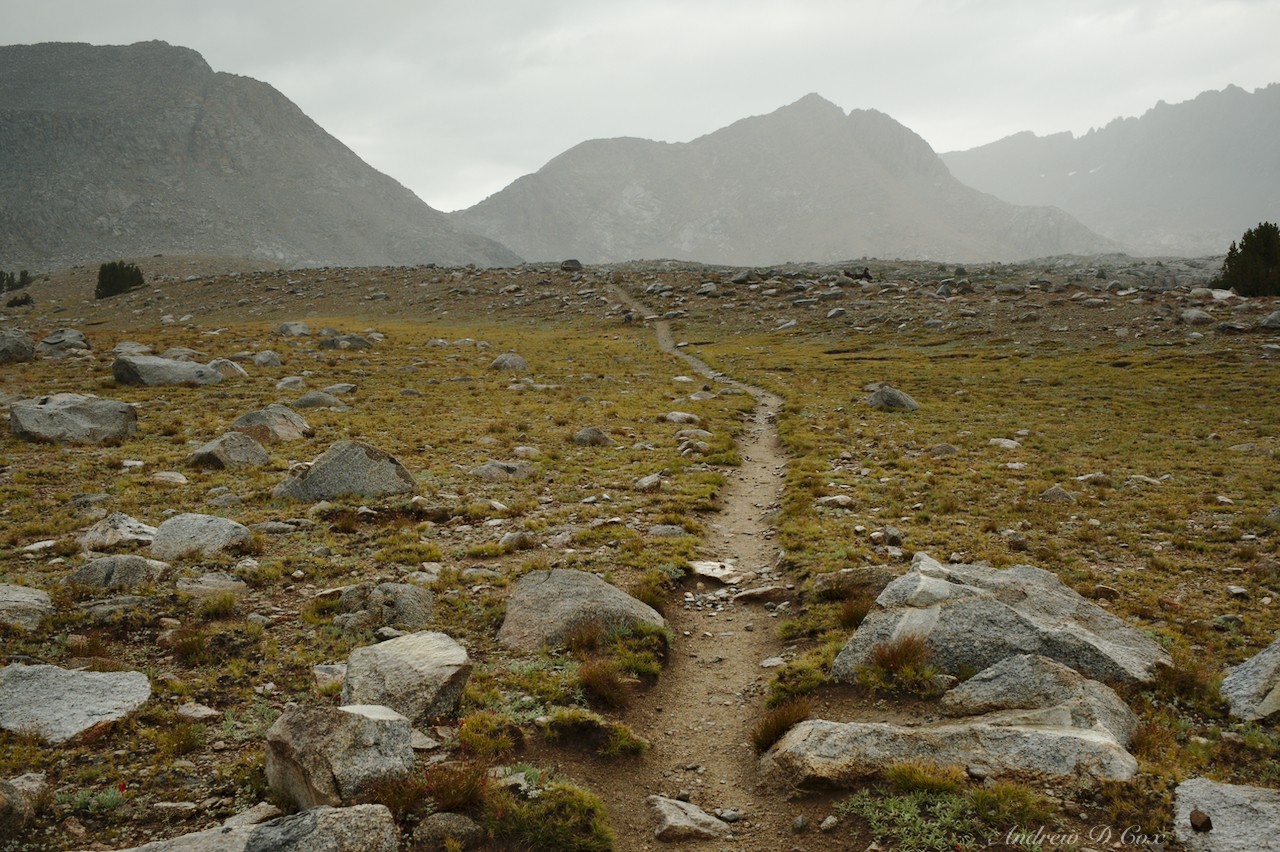
Satiated (for now), I adopt a more leisurely pace and walk up the JMT toward Upper Basin. Amanda and I traveled this very path just a few weeks ago, so the scenery isn’t very new, but the views of the mountains ahead keep me entertained for a while.

Remembering the beauty of the mountains surrounding Pinchot Pass, I glance back and am surprised to see that the skies over Pinchot are black as ink. Those thunderstorms are arriving sooner than I expected! I keep walking as the sky ahead of me remains bright, but the storms seem to be following me; the further north I travel, the larger the patch of black sky becomes.
I finally stop hiking when I reach Upper Basin. Beyond this point, the trees disappear and I’ll be left with absolutely no shelter. With the storms still approaching from the south, I scout around and find a flat patch of gravel and set up my tent. I sit outside for a while and watch the angry clouds move toward me, only retreating into the tent when the rain begins to fall in earnest. The thunder and lightning arrive soon thereafter, filling the air with sounds like the sky is being repeatedly torn in two. I stay in the tent, listening to podcasts, reading Roper’s book, and exploring the map to kill time.
Several hours later, the thunder fades away, leaving only a light drizzle. I’m tired of sitting around, so I pull on my rain jacket, pack up the dripping tent, and resume hiking. The sky has grown considerably lighter, and a sunny evening like last night seems likely.
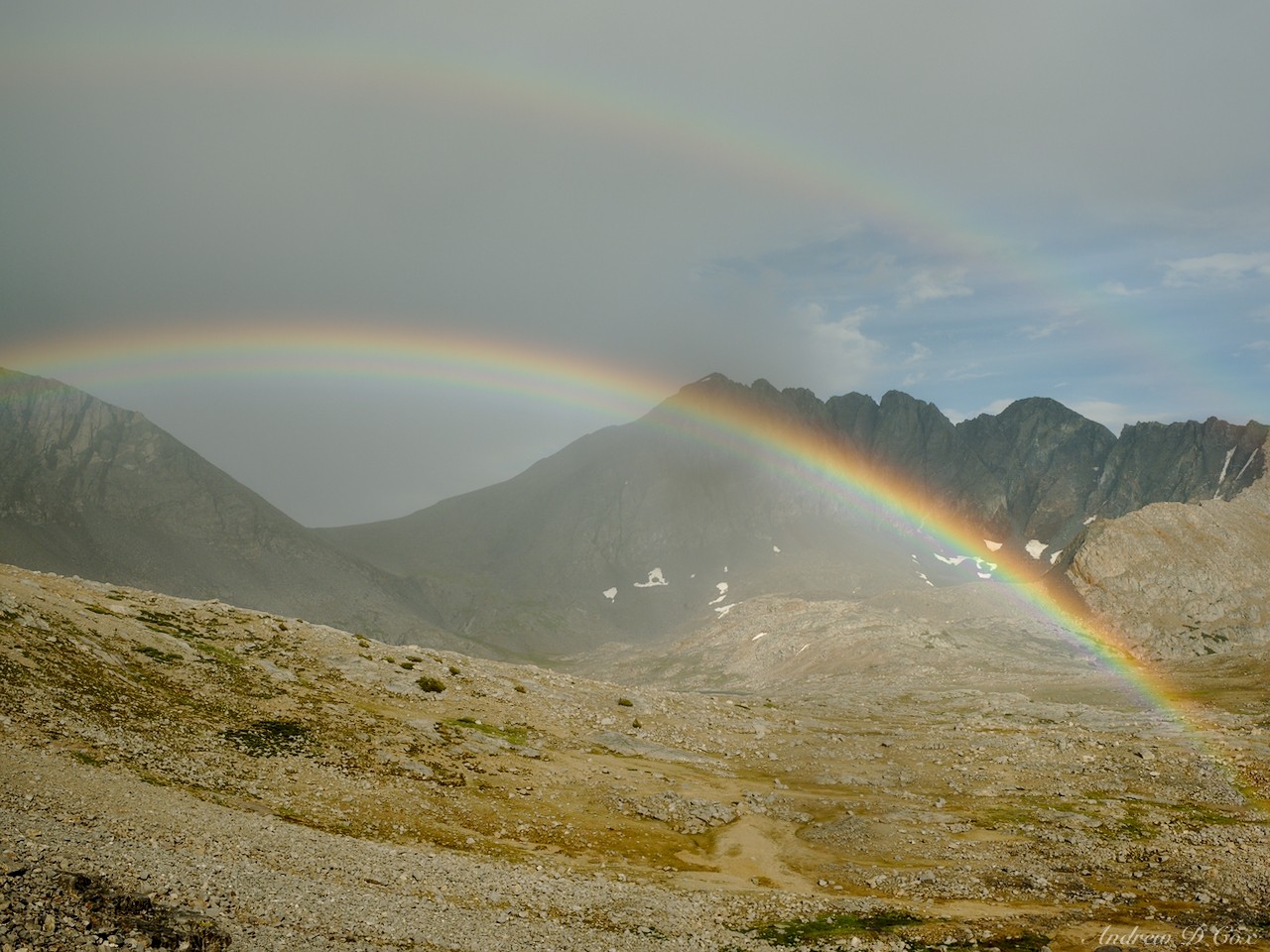
In the meantime, the drizzle continues as I leave the trees behind and begin zig-zagging up the switchbacks that lead to Mather Pass. I love how gentle the switchbacks are on the JMT; it makes gaining altitude a breeze! Partway up the trail I glance behind me and am awed by an incredibly bright rainbow stretching over Upper Basin. Just like during my trip to Humphrey’s Basin, it seems like Mother Nature is compensating for the dreary afternoon with this brilliant display of color!
Now in high spirits, I stride up the trail with renewed vigor. The rain soon stops and, by the time I reach the pass, it’s nearly impossible to tell that it’s been raining for the past three hours! Sunshine streams through the broken clouds, filling Upper Basin with warm evening light. What a beautiful vista!

Atop the pass, the sun shines brightly. However, the path below passes into shadow before reaching my destination for the evening, the Palisade Lakes. So, I take advantage of the wonderful weather and stretch out the drenched tent on some boulders to dry. While evaporation does its thing, I cook dinner and photograph some beautiful shooting stars in a nearby meadow. With a hot meal in my stomach, warm sunshine all around, and the end of today’s hike in sight, I’m happier than I’ve been all day.
In all the afternoon excitement, I’ve nearly forgotten than I’m now covering new ground on the Sierra High Route. Amanda and I hiked most of the “Cirque Country” section, ending at Upper Basin a few weeks ago before looping back to Road’s End. Since I passed through Upper Basin this afternoon, I’m now on my way to the next cross-country portion of the route!
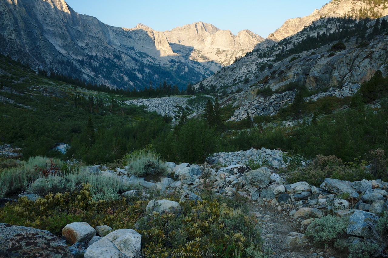
By the time I reach the lower of the two Palisade Lakes, dusk has fallen and I hurry to set up my tent before the light disappears completely. The surrounding peaks stand silhouetted in the colorful sunset, creating quite the backdrop as I unpack. I’m happy to lie down again, even if I did spend several hours this afternoon in the tent. It’s been a long day, and I’m excited to embark on an off-trail adventure tomorrow!


Beneath the Palisades
2 August 2018 | 13.3 mi | +4700 / -6000 ft | View on Map
I wake early in the morning and, after a quick breakfast, pack up all my gear and walk to the bottom of the lower Palisade Lake. From the outlet, I step off the trail and wander over to a steep wall northeast of the lake. Somewhere far above, currently hidden from view, is my next destination: Cirque Pass. After glancing across the face of the wall, I pick a route and begin scrambling up talus near a small creek bubbling over the cliffs. At first, the climb is simple class-II terrain: I need my hands to maintain balance, but not to pull myself over large boulders. However, I misjudged the talus and am soon faced with a few class-III problems. I don’t mind the challenge; it’s fun to do a little climbing in the morning!
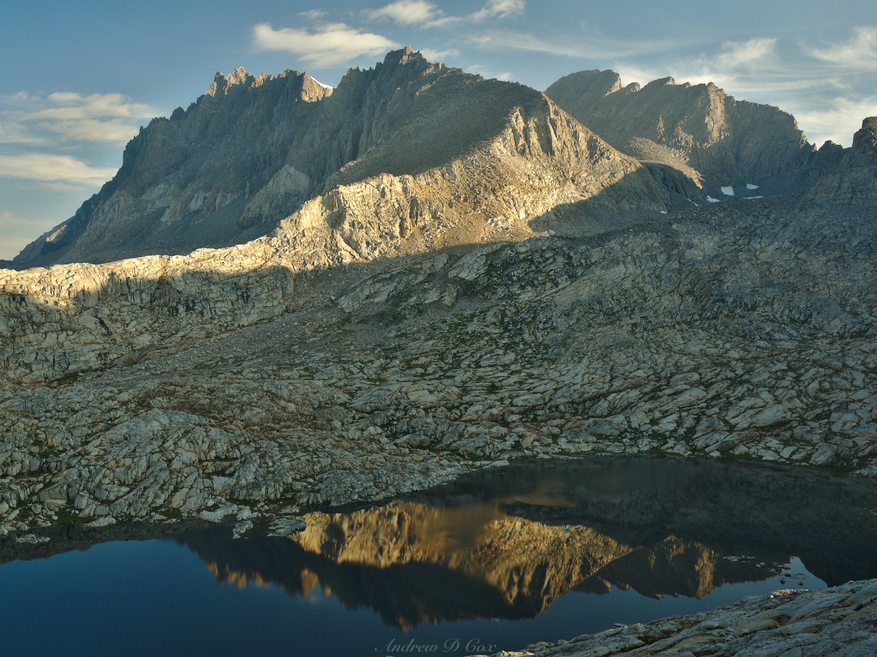
I climb higher and higher and soon reach a lovely bench with several small tarns scattered among the talus. The Palisade Lakes glisten in the morning light far below. Although the view reminds me of how far I’ve already traveled, a glance uphill reveals that the climb has only begun though the steepest terrain is now behind me.
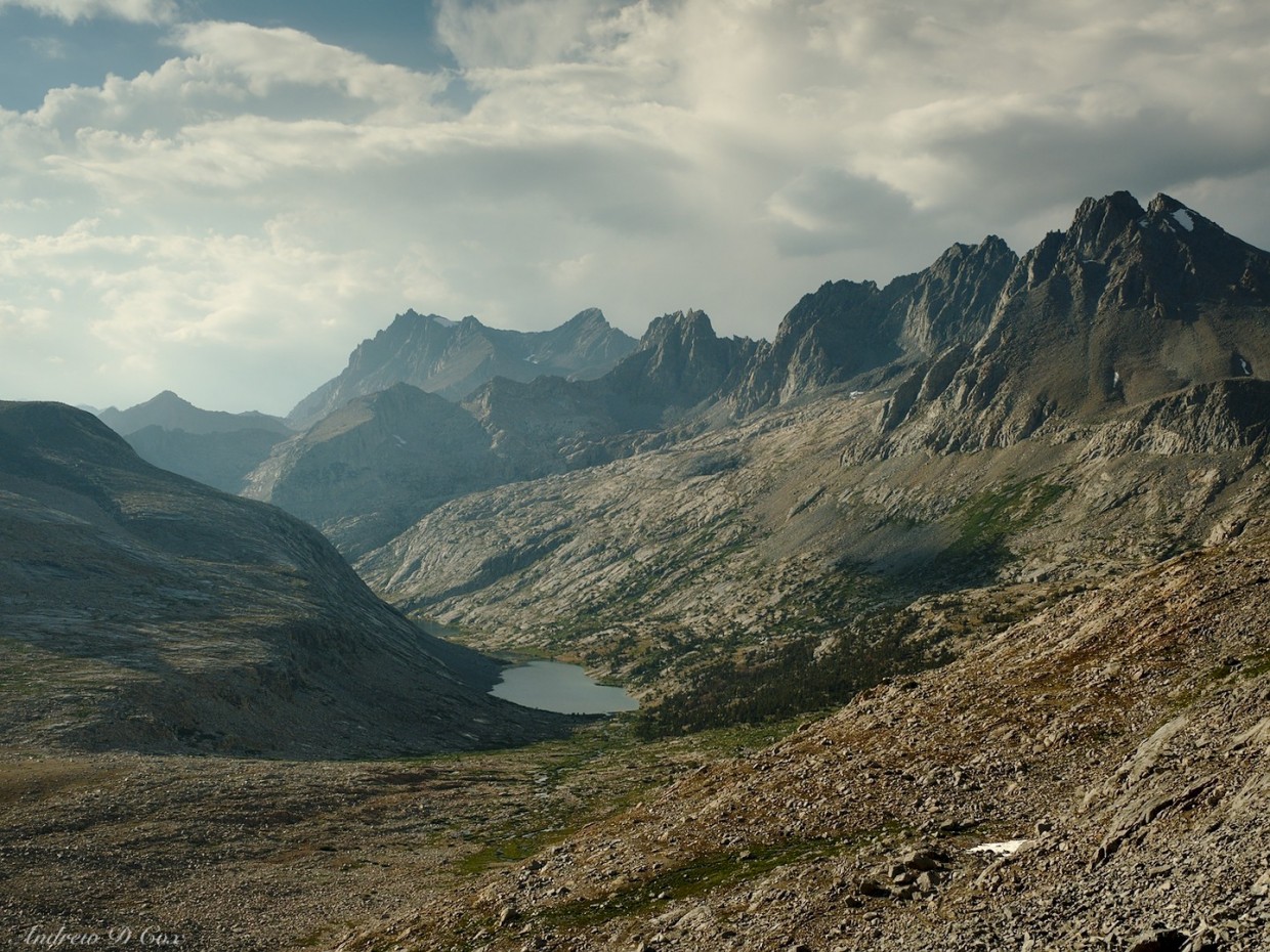
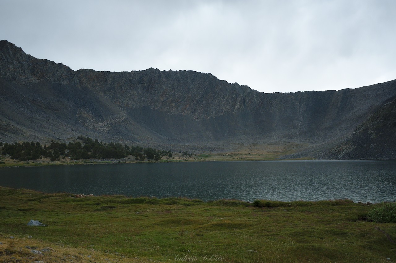
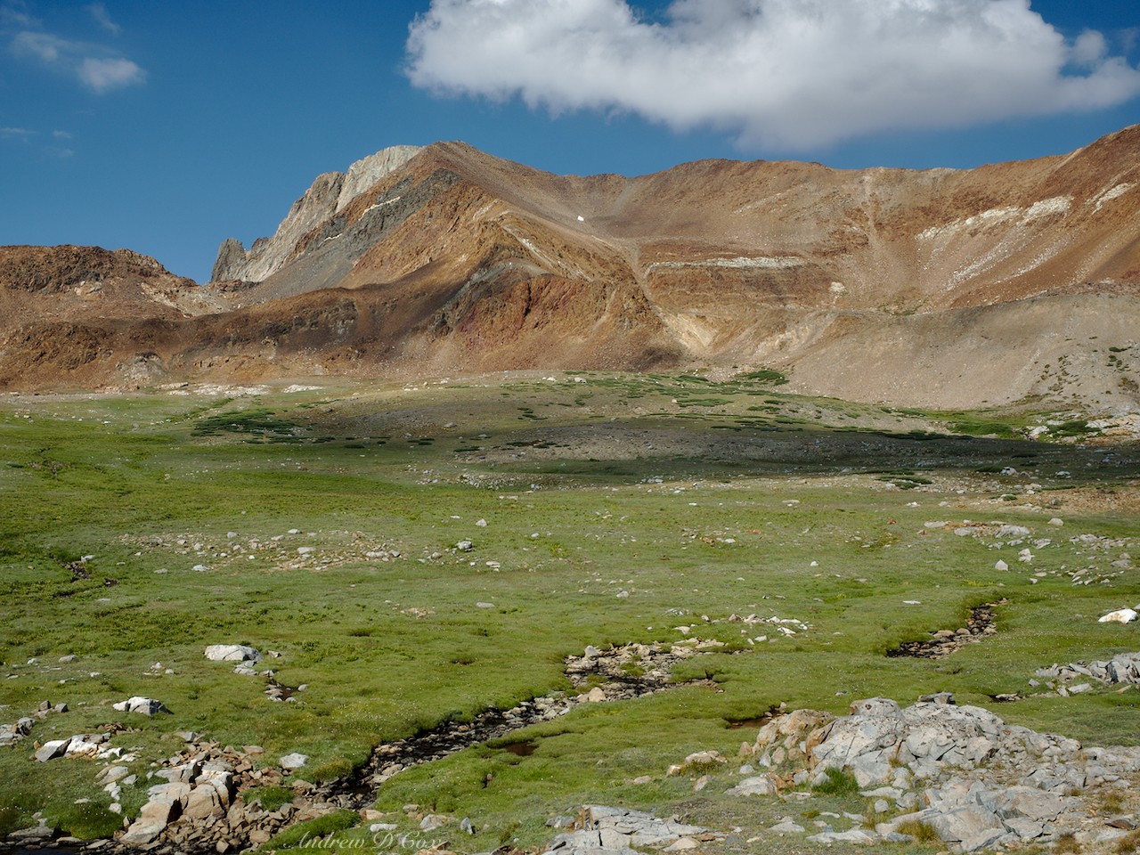
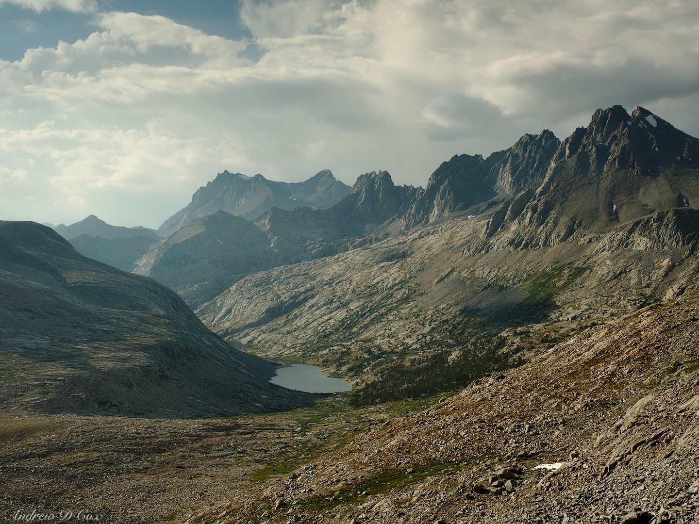
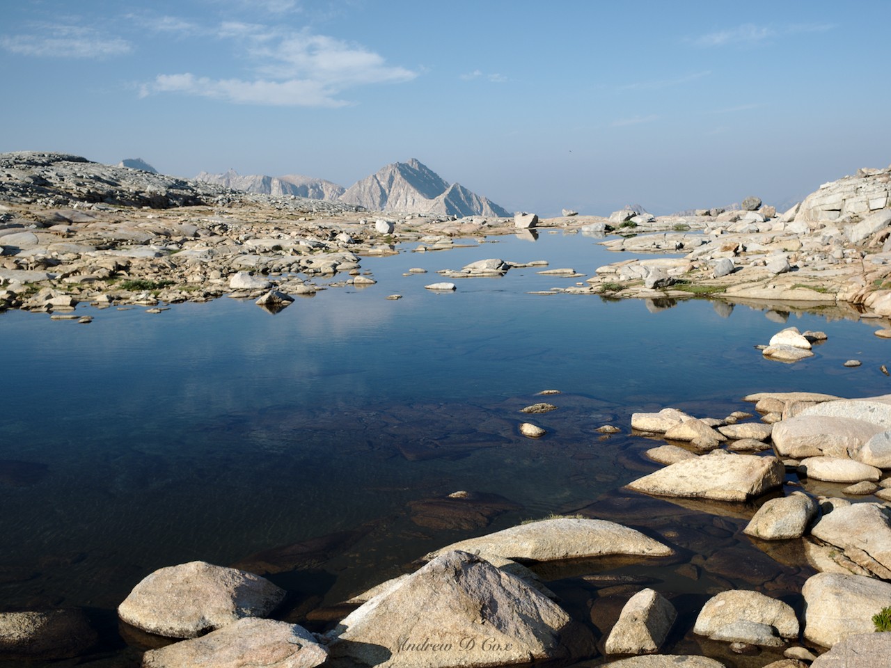
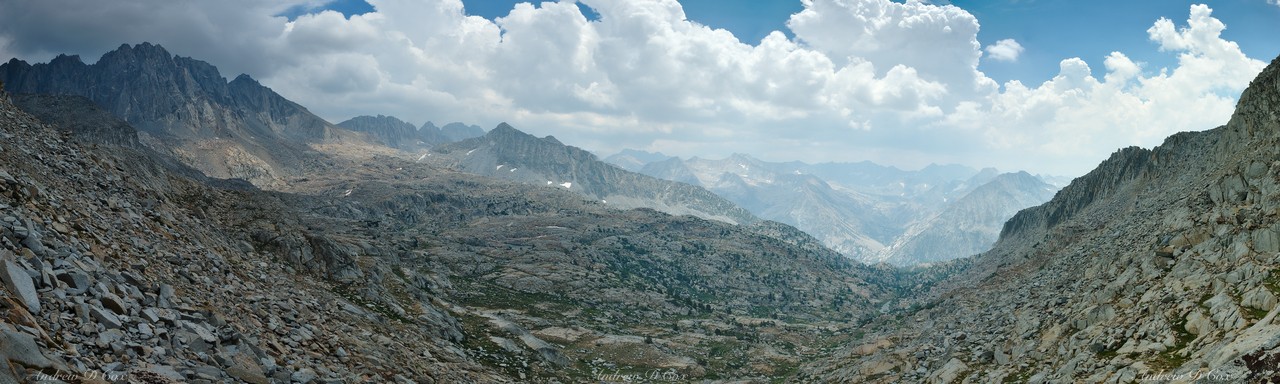
I wind between the tarns, striding up granite ramps toward the Palisades looming in front of me. Roper calls this terrain “easy,” and I’m reminded that he is referring to technical difficulty, not physical effort required to ascend. I agree with his assessment: I have no difficulty finding stable places for my feet as I trek toward Cirque Pass, but I’m pretty worn out by the time I arrive at the saddle. I pause for a few minutes to catch my breath and also to admire the view in front of me. A large lake, completely encircled by granite slabs and talus, fills the valley below. It’s a beautiful vista, one that most hikers never take the time to see since it is far from the JMT. That being said, I spot a few people camped near the bottom of the lake; even the cross-country routes through the Sierra Nevada are popular.
The descent from Cirque Pass proves to be pretty straightforward and I’m soon hopping across the outlet creek of the large lake. I chat with the campers I spied from above and learn that the three of them are brothers, that this is their first trip to the Sierras, and that they’re hiking the Sierra High Route. I’m impressed by their ambition! I’m not sure how comfortable I would be attempting an off-trail route on my first visit.
After chatting with the brothers for a few minutes, I continue on my way. A grassy chute leads me to the top of a hill overlooking the lake, with a smaller pond on the other side. I stash my gear at the pond and take off up a hill to the east, heading for the slopes of Mt. Sill (14,153′). Roper includes mountaineering instructions for local peaks in his route description and I’ve decided to attempt this one. As I climb higher, the talus grows larger and I encounter a few snowfields. I’m not 100% sure exactly which peak is Mt. Sill, but the approach to all of the candidates is more or less the same, so I continue scrambling upward.
After crossing a hundred yards of sloped, icy snow, I pull out my phone and check my location on the Gaia GPS app to figure out which summit is the correct one. A few seconds later, I have my answer. I’m still quite some distance from the peak, and the entire route appears to consist of loose slate, the kind that slides under your feet like sand; two steps up, one step sliding back… Rather than toil on for another hour to reach the summit, I decide to return to my gear and continue on the “established” Sierra High Route. I’ll have to come back another time for a more dedicated mountaineering trip; hike fewer miles between campsites, but spend extra time scrambling up to the tops of all these awesome peaks. For now, I’ll content myself with the challenge of navigating the Sierra High Route.
Back at the pond, I pick up my backpack and begin the next portion of the route. I scramble up steep, unpleasant dirt and gravel for a while before reaching more promising granite ledges. Still, I struggle a bit with the route finding and am forced to backtrack a few times when I encounter class IV sections. But the struggle is all part of the route, right? I’m not following a trail, I’m exploring the rugged Sierra Nevada high country!
The views from the top of Potluck Pass prove to be well worth the effort. Ridge after ridge of serrated granite mountains stretch across the western horizon in front of me. Somewhere below is the John Muir Trail, that thoroughfare through the Sierra Nevada. The thought that dozens of excited hikers are passing by just a few miles away with absolutely no knowledge of this fantastic vista is a bit humbling; these mountains are vast and complex, and there will likely always be new spots and vistas to discover!
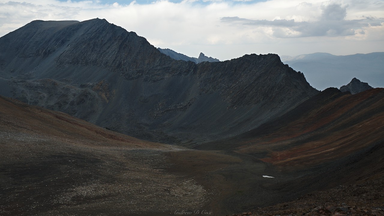
The route beyond Potluck Pass proves much easier than the terrain leading up to it. Rather than descending into the Palisade Basin, I contour along the upper edge with the sharp spires of North Palisade and Thunderbolt Peak looming overhead. Speaking of thunderbolts, the skies are once again filling with puffy clouds… third day’s the charm for no rain?
Noting this forecast of storms to-be, I hurry along, continuing to contour over to the Barrett Lakes. I’m able to stride along smooth, granite slabs for most of the walk, and I’m soon on the opposite side of the Palisade Basin from Potluck Pass. I make a mental note to come back here some time to explore the tiny lakes and stands of trees that dot the massive basin. For now, I need to continue on and get over Knapsack Pass before the storms roll in.
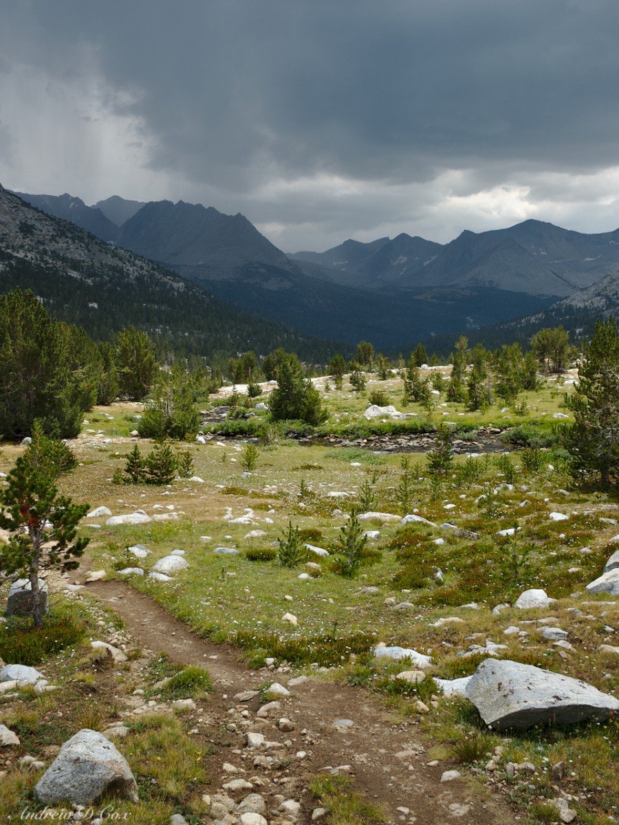
The Sierra High Route winds between several of the Barrett Lakes, all of which are beautiful. The towering cumulonimbus clouds reflected in their still waters are particularly impressive! Here’s the thing about inclement weather in the mountains: it’s just way more interesting to photograph the Sierras when the weather is “bad.” A typical summer day with a cloudless sky and endless sunshine is certainly more pleasant and less stressful for hiking, but the harsh light and sharp shadows are not great for photography. The clouds add lots of interest to the sky (and shade!), particularly when they get dark and stormy.


Alas, this is a long distance backpacking trip, not a dedicated photography trip, so I can’t sit and watch the light change all afternoon. My final pass for the day, Knapsack pass, lies not far north of the Barrett Lakes. Reaching the pass is a fun route-finding puzzle. There are many opportunities to drop deep into the valley below the pass, but I prefer not to lose too much altitude since I just have to gain it back to reach the saddle. On the other hand, climbing too high means struggling through steep talus, which can be tedious even when the rocks are stable (they may not be). I spot footprints a few times while navigating through the rough terrain. I wonder if they belong to the brothers I met this morning, or to some other group of adventurers?
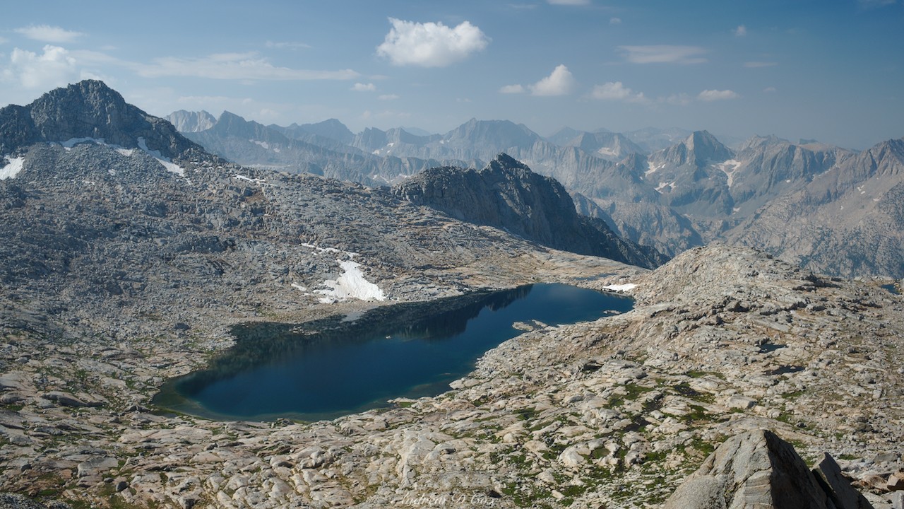
Although my stomach is growling, I press on without lunch until I gain the saddle at Knapsack Pass. The clouds overhead aren’t too dark and, since I’m absolutely starving, I plop down on a granite block and eat, daring a storm to arrive. To the north, dark clouds hover over the Black Divide and Muir Pass, the next pass I’ll reach on the Sierra High Route. However, the storms seem to be blowing from the west to the east, so I sit and watch as distant sheets of rain pummel the mountains. Immediately below Knapsack Pass, Dusy Basin remains dry. Patches of sunlight wander around the landscape, spotlighting the various lakes as the clouds drift by.


Once I’ve finished eating, I scramble down the north side of the pass. It seems that Dusy Basin is the place to be this afternoon; massive clouds gather over Palisade Basin behind me while I descend, but they sky over Dusy Basin remains relatively clear. During the next few hours, I wander past half a dozen beautiful lakes, pausing only once to take shelter from a mid-afternoon drizzle. This valley is another spot I would love to revisit!

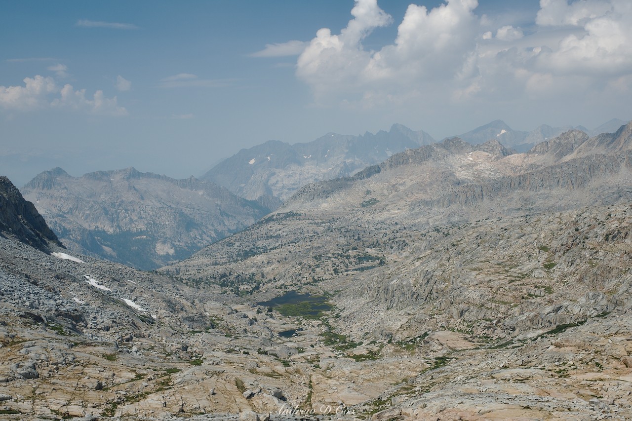
Below the Dusy Basin lakes, I step onto an established for the first time today. Only a few tenths of a mile later, I begin passing groups of hikers, including a scout troop camping at one of the lakes. After the day’s challenging terrain, walking along the trail is astonishingly easy and I soon find myself at the mouth of the valley looking into the mind-bogglingly massive Le Conte Canyon. Rays of sunlight stream through the broken clouds overhead, illuminating pyramids of glistening granite on the opposite side of the canyon. It’s an impressive sight, one of most spectacular I’ve seen so far on this trip!

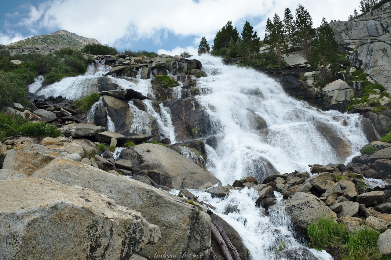
I pause for a few minutes at the edge of the canyon to admire the view and then begin what are to be several unpleasant hours of switchbacks that will deliver me to the canyon floor. A dull headache only enhances the tedious downhill slog. Two features distract me from the miserable descent: a truly massive cascade tumbling down the canyon wall directly next to the trail, and several wonderfully shady stands of red firs and twisted junipers midway down the canyon.
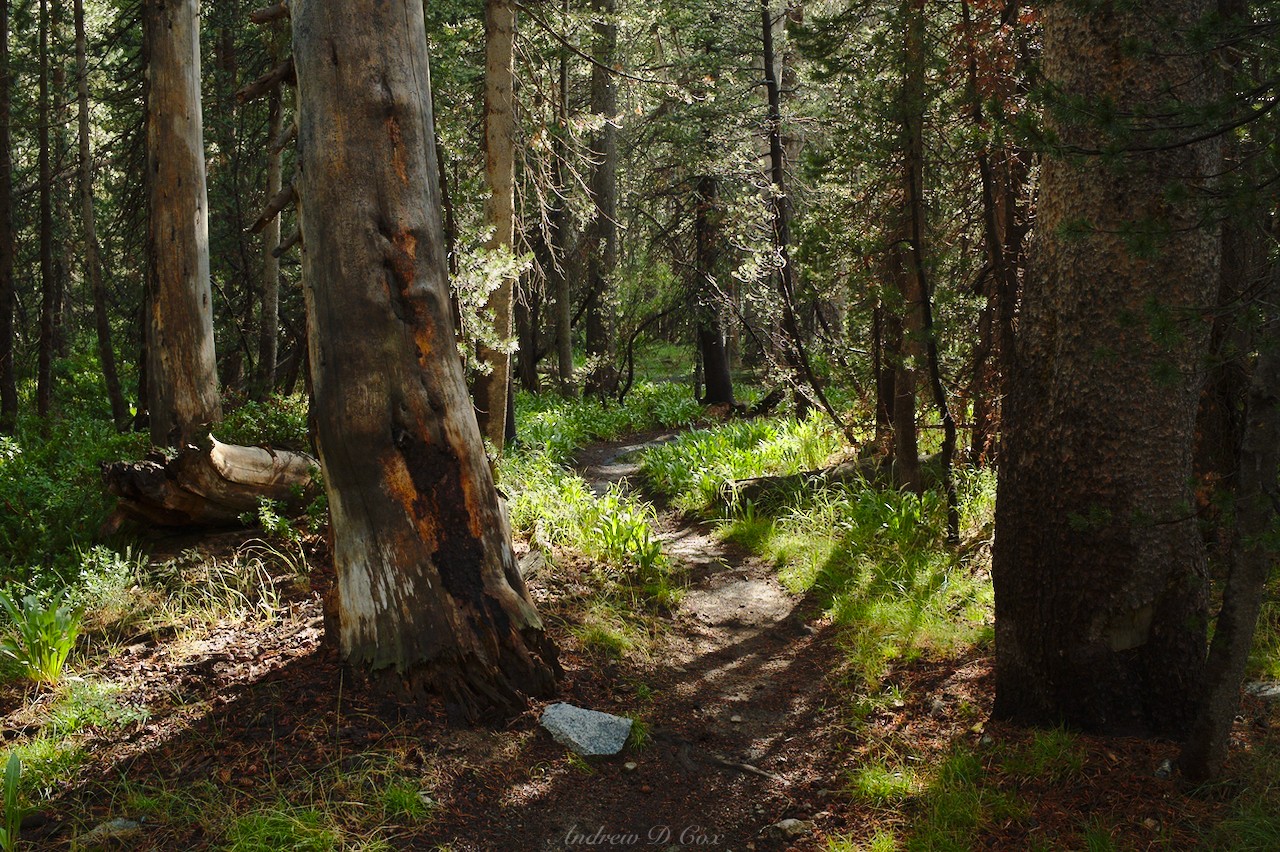
I eventually reach the bottom of Le Conte Canyon, disgruntled from the 2,500′ descent, and begin searching for a campsite. Surprisingly, walking uphill feels infinitely better than downhill at this point, so I continue northbound on the JMT for a little while. The North Fork of the Kings River rushes downhill in the opposite direction, crashing over boulders and fallen trees. For perhaps a mile, I walk through dark, cool trees. I particularly enjoy spotting silvery mountain hemlocks along the way.
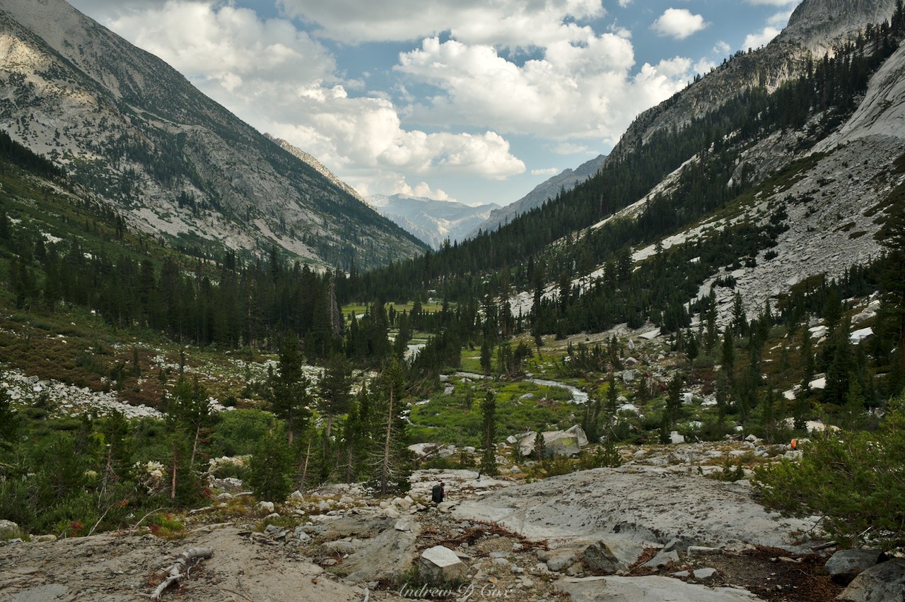
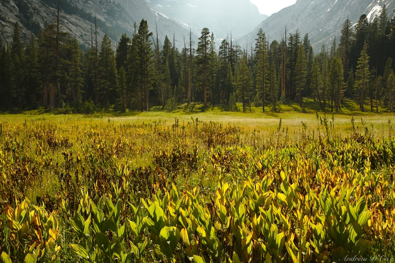
Before long, I reach Little Pete Meadow where the river slows and winds gently through expanses of long grass. All of the campsites I find are already full, so I continue up the trail a little further. A short climb brings me to Big Pete Meadow, which glows gold in the late evening sun. I find a nice set of empty campsites near the grass and gratefully drop my backpack. A doe and two fawns wander past while I unpack, but don’t seem overly concerned about me, which is a fun contrast to deer that live closer to civilization and have learned to be afraid of humans.
After the long day of hiking, I’m excited to eat dinner and relax for the rest of the evening. However, before settling into lethargy for the night, I spend several minutes stretching all of the aching muscles in my legs. I’ve learned the hard way that the key to minimizing muscle pain is a good stretching regimen. The rest of the evening passes pleasantly enough and I’m soon cocooned in my warm sleeping bag. Tomorrow I’ll continue up the JMT all the way to Evolution Lake, then trek cross-country once more into what Roper calls “Whitebark Country.”
Use the links below to read about other sections of the Sierra High Route
Scott 6 September 2020
Wow incredible blog. Love the pictures and how hard this area is to access which keeps it pristine and generally free of the jostling crowds. Did you have a favorite section of the high route out of curiosity and spending a bit of time in the sierras myself.
Andrew 7 September 2020 — Post Author
Thanks, Scott! The absence of people and pristine wilderness are some of my favorite thinks about this route too. I can’t choose a favorite part of the SHR; so much of it is beautiful and perfect! Plus, the weather, fire activity, and my day-to-day mood on the trail casts different sections in different light. That being said, I loved the entire off-trail portion in “Cirque Country,” the walk through Humphrey’s Basin, the Fish Creek basin, the cross-country stretch between Minaret Lake and Blue Lake Pass.
Do you have a favorite area of the Sierra? I’m always interested in exploring new places!
Scott 7 September 2020
Hey Andrew thanks for writing back and again stellar blog! I think yours has best to capture the scenery of the SHR compared to others, although just reading about the adventure is incredible for all that undertake this route, it is so wild and diverse. As a fly fisherman my treks into the Sierras are always a bit fish focused. Humphrey’s basin over to French and then up to Royce lakes is a fisherman playground.
I am with you on any cross country in the Minaret region. I haven’t done the full stretch you have but it was my favorite from the pictures. Just stunning.
I am also really interested in the first leg to grouse > lakes basin > etc… Although the pass out of their Frozen Lake pass looks a bit gnarly. Haven’t been to that area before and looks so peaceful.
Sorry to ask about a favorite, really impossible question Sierras are too grand and unique to pin down.