Day six of the Oregon peak-bagging trip! After two multi-day trips to climb Mount Jefferson, North Sister, and Middle Sister, Linda, Craig, and I took on some shorter hikes today. The first is Broken Top, a pretty straightforward peak with only a little technical climbing and a gorgeous approach hike. Craig and I also climbed Mount Bachelor, a class 1 walk-up.
Broken Top
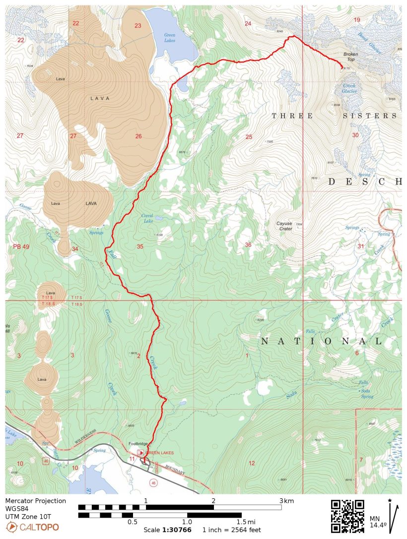
28 July 2022 | 13.1 mi | +/- 3700 ft
Difficulty: Class 5 [learn more]
Location: Deschutes National Forest, Oregon | Home of the Warm Springs, Siletz, and Grand Ronde peoples | View on Map
Route: Follow the Green Lakes Trail and then a well-traveled climbers’ trail that doubles (at least initially) as a path to an established campsite. Follow the trail to the saddle on the northwest ridge and then follow the ridge to the summit block. A 10-foot step can be climbed by the crack (class 5) at the top of the ridge or via a class 3 chute about 50 feet to the right. Follow the well-worn “catwalk” (class 1) to the summit (short class 3 scramble).
Permits and Regulations: Permits are required for both day and overnight use of the Green Lakes Trail between June 15 and October 15. Parking costs $5/day, but recreation passes like the Interagency Pass are also accepted. Wilderness restrictions apply, and make sure to leave no trace!
As has become habit, I’m up at four again this morning for a pre-dawn start. Craig, Linda, and I begin up the Green Lakes Trail at 5 AM. Like most of the mornings this week, it’s only barely cool. We stroll through the woods in the semi-darkness, passing several waterfalls on the aptly-named Fall Creek. We leapfrog with a group of three climbers that are also climbing Broken Top today and commiserate with them about the plentiful mosquitoes.
Further up the trail we emerge from the dense forest to an open strip of meadow with a towering lava field on one side. The creek meanders through the grass, reflecting the soft morning light hitting the mountains ahead of us. We don’t stop to admire the scenery though – too many mosquitoes!


After a bit of uphill hiking we reach the Green Lakes. The path splits in many directions here, leading to various established campsites and other trails. The open meadows surrounding the lakes give us our first clear view of Broken Top as well as a spectacular view of South Sister bathed in the dawn light.


A short distance past the Green Lakes we turn onto one of the campsite trails that doubles as the climbers’ trail to Broken Top. The poor campers there probably didn’t realize that half a dozen people would come marching through their campsite at 6:45 in the morning. The climbers’ trail winds steeply through the forest, making a beeline for the saddle on the northwest ridge of Broken Top. Linda, Craig, and I settle into our own paces as we trudge up the steep path, leaving the group of three behind.
By the time we reach the ridge at 7:30, my Achilles tendons are feeling pretty worn out. All that steep hiking on inclined ground is tough! We rest for a while on the saddle, putting on sunscreen and munching on snacks. A well-worn path continues up the ridge, so we follow it once we’re rested.


I enjoy this ridge walk quite a bit. The views are tremendous, particularly to the north where all three sisters dominate the landscape. The ground is also stable and not too steep, at least compared to the ridges we’ve climbed on Mount Jefferson, North Sister, and Middle Sister.
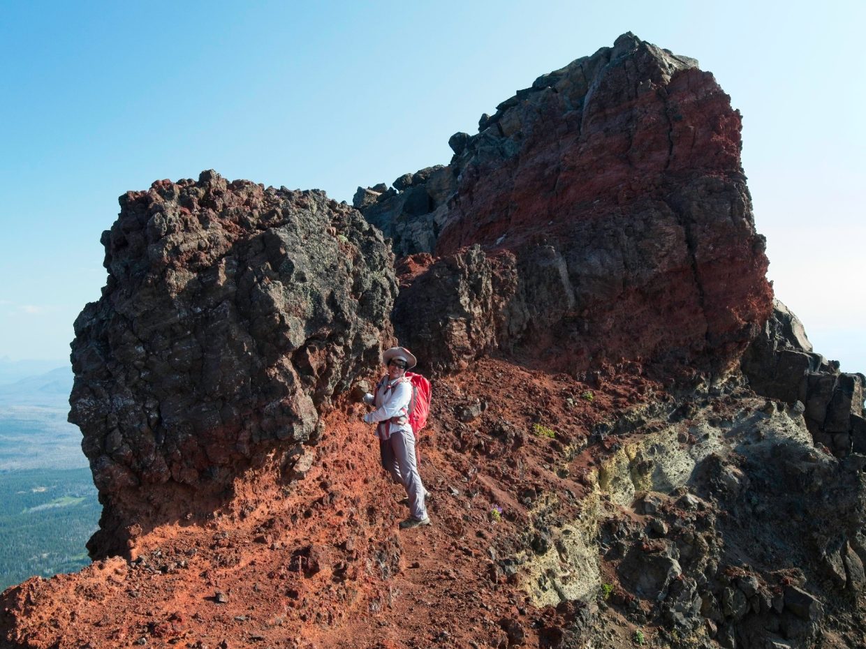
After an ascent of about 1100 feet we reach the crux of the climb: a 10-foot rock step. We look around on climbers’ left for an easy route up and although the slope isn’t too steep, the rock is so horribly loose that we don’t dare attempt an ascent. So we return to the main rock face; Craig and Linda explore to the right while I take a good look at a crack that extends all the way to the top of the wall. The climbing looks straightforward enough (easy 5th class), so I sling the camera over my shoulder to keep it out of the way and climb up. The holds are pretty good and I make it up without any trouble. Rock shoes would be nice for some extra security, but they’re hardly necessary. I yell down to Craig and Linda that the climb “goes” but they’ve already found an alternate way up: a loose class 3 chute to the right of the crack. They top out just moments later and we continue the climb together.
The route descriptions I’ve read online describe the route to the summit as a “series of highly exposed catwalks.” It’s a reasonable description; there are a few short and easy class 3 problems, but otherwise we walk along small ledges with steep slopes dropping off below. Despite the exposure, I feel safe on the walk over to the summit. The ledges are all wide enough to walk straight across and the ground is flat and smooth. We reach the summit at 8:45 and relax for a while, admiring the views, including a massive caldera below.


On the way back we rappel down the rock step instead of downclimbing it. The rappel isn’t necessary, but we (Craig) carried the rope all the way up here and we’re in no particular hurry, so why not do the easy and safe thing? A trail runner scrambles up the class 3 chute while we’re rappelling and then passes by on his way down a few minutes later.
Once we’ve packed up our climbing gear, we return down the ridge, encountering the group of three soon after leaving the summit block. They look like a guided group because the leader has the other two tied into a very short rope. After wishing them luck with the summit, we continue down the ridge and then the climbers’ trail. I’m glad to reach the end of the steep slopes at the Green Lakes Trail but don’t particularly enjoy the walk out. Maybe I’m not getting enough sleep, or maybe it’s just the heat, but I feel like I’m sleepwalking at times.
We reach the trailhead a little before noon. Linda is leaving us today to start her drive home, so Craig and I say goodbye to her and then figure out what we’re going to do for the rest of the day. Although I’m pretty tired, I don’t really want to sit around all day so I agree to join Craig on a short, relatively easy jaunt up Mount Bachelor.
Mount Bachelor
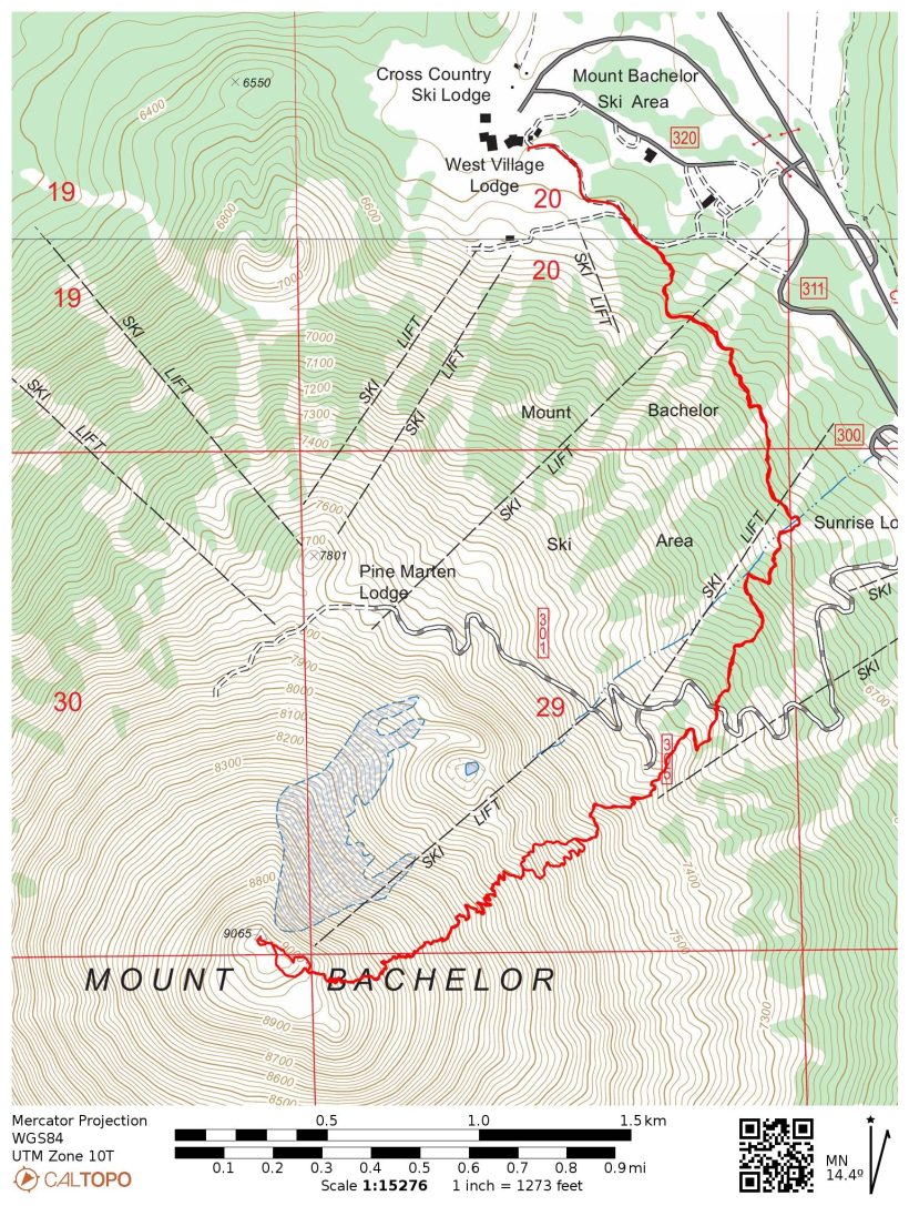
28 July 2022 | 7.2 mi | +/- 2800 ft
Difficulty: Class 1 [learn more]
Location: Deschutes National Forest, Oregon | Home of the Siletz, Grand Ronde, Klamath, and Molalla peoples | View on Map
Route: A trail leads all the way to the summit of Mount Bachelor – just follow the signs and copious number of painted arrows.
Permits and Regulations: There don’t appear to be any permit requirements or payment restrictions at Mount Bachelor. Visit the ski resort website for lots of great info about hiking the mountain and other summer activities.
Craig and I drive over to the Mount Bachelor Ski Lodge (a mountain biking area in the summer) and eat some lunch. It’s tremendously hot out, so I make sure to drink plenty of water and Gatorade. At about 13:00 we begin our hike up Mount Bachelor following one of the ski resort cat trails. Signs direct us to the summit trail, which winds pleasantly through the forest for a while. As we stroll through the woods, the clouds gather overhead and thunder rumbles a few times. We continue hiking anyway; we’re not above treeline yet and the storm may very well blow itself out.
Thankfully, the thunderstorm does relent before we reach the exposed upper reaches of Mount Bachelor. A light drizzle falls for a while, which feels amazing. Without the cloud cover and the rain, we would be roasting up here. The hike to the summit is easy enough, but I’m really dragging by the time I reach the top at 14:40. As far as peaks go, this one isn’t particularly noteworthy or scenic. It’s mostly a pile of volcanic boulders and though the views are expansive, they’re not as nice as the ones we were afforded this morning on Broken Top.


After a long rest, many snacks, and some electrolytes, I’m ready to hike out. I follow Craig down the mountain; we arrive back at the parking lot at 16:30. Craig wants to hit one more peak but I’m too tired for any more hiking, so we agree to meet up tomorrow morning for one more hike: South Sister.