At 11,499 feet, San Gorgonio Mountain is the tallest peak in southern California. In the summertime, lots of hikers make the trek to the summit but, judging from this weekend’s excursion, it seems like the mountain isn’t visited nearly so often once snow falls. I’ve been trying to get more winter mountaineering experience and the weather this weekend looked great, so I invited Craig to join me on a day hike up to the summit. We got to use snowshoes, crampons, and ice axes on this climb and the conditions were absolutely perfect!
Trip Planning
Specs: 13.5 mi | +/- 4500 ft
Difficulty: Class 1 [learn more] with steep snow and ice (bring crampons, ice axe; snowshoes or similar flotation may be very useful as well)
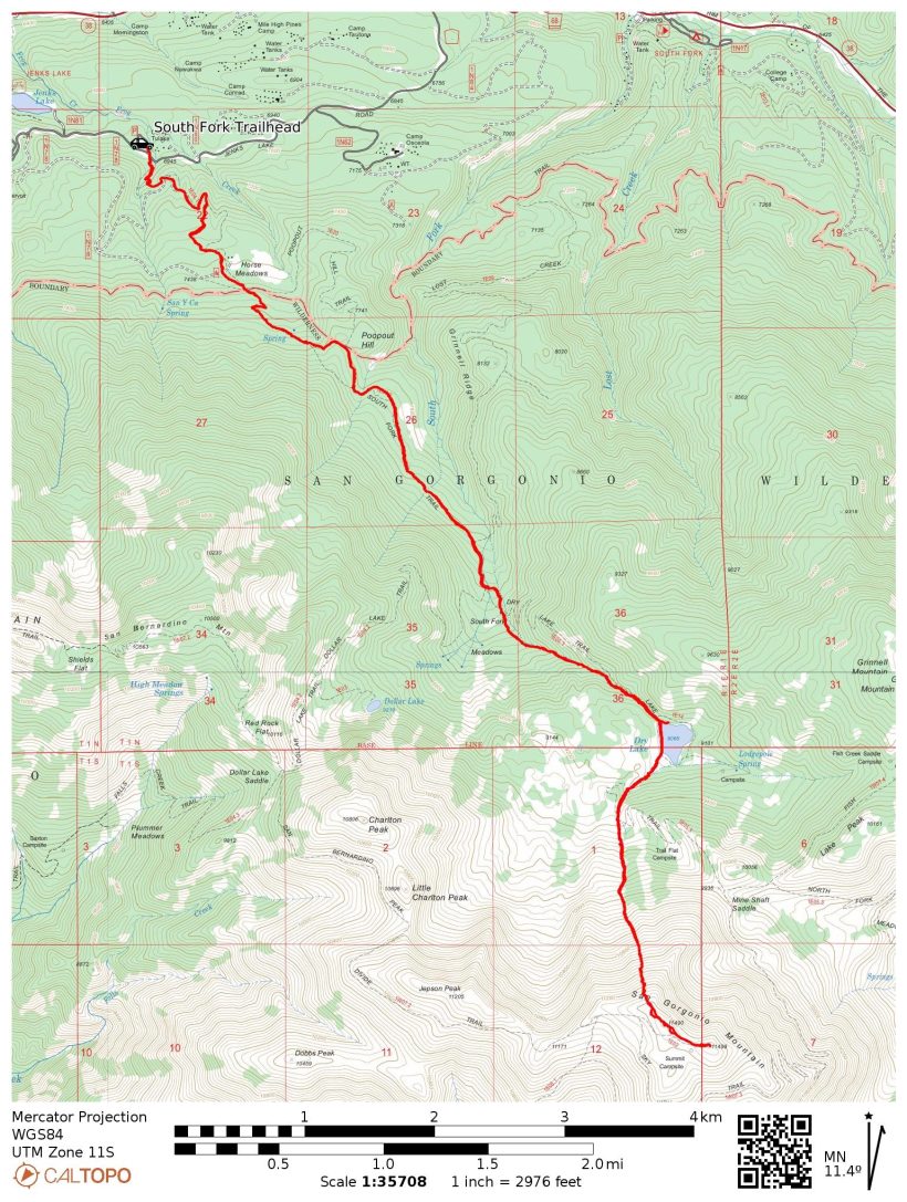
Location: San Gorgonio Wilderness, San Bernardino National Forest| Home of the Serrano and Cahuilla peoples | View on Map
Route: Begin at the South Fork Trailhead and follow the trail about 0.4 miles past the south shore of Dry Lake. Rather than continue up the trail, follow the inlet creek directly south toward the summit. In front of you are four obvious chutes; aim for the second from the left. Once atop the ridge, walk over to the summit. Descend via the same route.
Permits & Regulations: Permits are required for both overnight trips and day hikes in the San Gorgonio Wilderness; visit the San Gorgonio Wilderness Association to reserve one. Additionally, you’ll need a pass (Adventure Pass or Interagency Pass) to park at the trailhead. As always, practice the leave no trace principles!
Resources: I like the Tom Harrison map for this area. Check SoCalSnow.org for current (updated weekly) snow conditions. Other websites like AllTrails and the San Gorgonio Wilderness Association forum may provide additional up-to-date reports from hikers. The National Forest page for the South Fork trailhead also supplies a wealth of information.
San Gorgonio via North Face chutes
12 Mar, 2022 | 13.5 mi | +/- 4500 ft | View on Map
Craig and I pull into the South Fork Trail parking lot at about 5:15. It’s chilly, so we put on a few layers while we organize our gear and lace up our boots. After a quick stop at the restroom, we begin hiking up the trail. The first hints of sun brighten the sky enough that headlamps are unnecessary as we clomp up the frozen dirt trail in mountaineering boots. They’re not the most comfortable footwear for this terrain, but I’m sure they’ll be more comfortable (and useful!) once we reach the snow.
About 1.3 miles up the trail we reach the San Gorgonio Wilderness Boundary and get our first look at the north face of the mountain. Four snow-filled chutes stand out between the trees and wind-swept scree slopes; we’ll be climbing one of them!
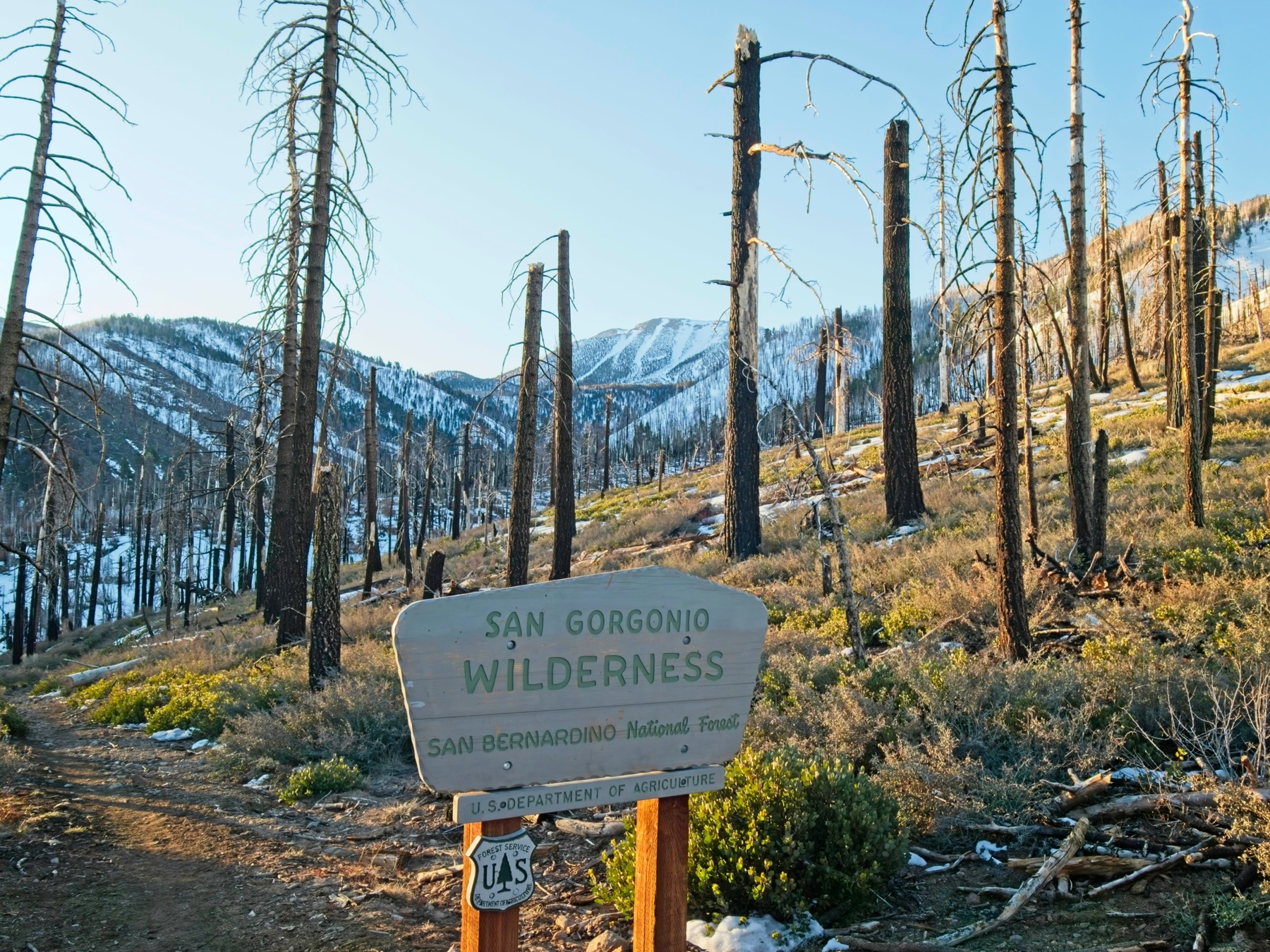
We trek through the fire-scarred (2020 Lake Fire) landscape for another 30 minutes or so before reaching consistently snow-covered trail. Still in the shade, most of the route is frozen solid but isn’t too slippery so we continue on without any traction devices. The sun begins to peak over the ridge as we approach Dry Lake, casting long shadows through the skeletal remains of the forest.


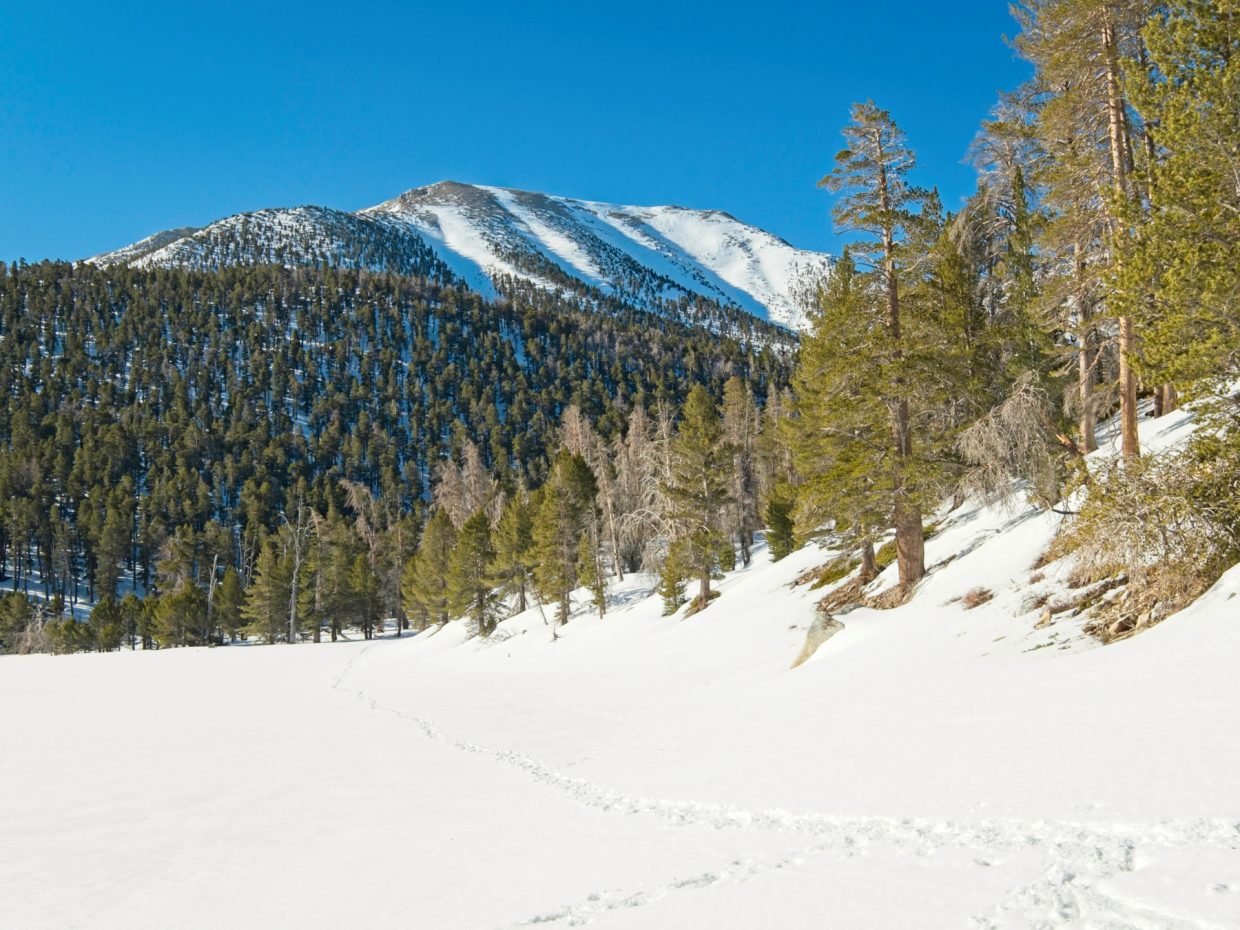
At 8:00 we reach Dry Lake, an awesome plane of radiant snow. We take a break in the warm sunshine and chat with another climber named David who started at the trailhead a little before we did and is heading up to the summit along the same route as we are. We sit for a little while, munching on snacks, sipping ice cold water, and staring up at the four chutes on the north face of San Gorgonio Mountain. The snow in the left-most chute tops out before reaching the summit ridge, so we eliminate that option immediately. The second from the left looks a little steep at the top, but maybe less steep than the two chutes on the right which appear to have a near-vertical headwall of snow (not quite a cornice, but close) at the ridge top. We still have a little further to go before we have to commit to one or the other, so we put off the final decision for now.
The boot track beyond Dry Lake contains many fewer footprints than the path to the lake and is much less packed down. We do fine in our boots for a little while but soon begin sinking in; time for the snowshoes! Craig and I say goodbye to David (who doesn’t have snowshoes today) and crunch up the canyon, following a set of footprints toward the north face of the mountain. We make good time thanks to the snowshoes, but the slope grows steeper as we ascend and the elevation begins to slow us down.


Partway up the chute we meet another pair of climbers who camped at Dry Lake last night. They’ve swapped out their snowshoes for crampons since the snow has transitioned from soft and sugary to solid and icy. Craig and I continue on in snowshoes for a while (they have pretty sizable spikes for traction) but I give up on them about three quarters of the way up the chute. My calves are burning from the constant effort of keeping the front edge of the snowshoe engaged on the ice, and my old snowshoes don’t have the climbing bar that makes climbing steep slopes more comfortable and efficient. So I pause for a few minutes to put on crampons and am immediately glad for the swap. Craig continues straight up the slope on his snowshoes while I zig-zag and side-step my way up to the top of the chute.


We leave our snowshoes and crampons at the top of the chute and set off across the ridge toward the summit. It’s a pretty straightforward walk on talus, scree, and soft snow, though we do slip on a few surprise ice patches. Once at the summit we pull on all of our layers to keep out the icy wind and then relax for a little while. San Jacinto, another massive peak just to the south, appears surprisingly dry but maybe the pines that cover the upper slopes are just hiding the snow from view.


After eating “lunch” (it’s only 10:30, but we’re hungry!), Craig and I walk back over to the top of the chute. Along the way we pass the two climbers we met in the chute earlier this morning and find their gear next to ours at the top of the chute. Craig swaps his snowshoes out for crampons for the descent and then we’re on our way down the mountain. Thankfully, the chute isn’t too steep and we’re able to make our way to softer snow very quickly. After packing the crampons away, Craig tries a glissade down the bottom half of the chute, but the snow is too soft to slide down at this shallow an angle. We end up plunge-stepping down to the bottom of the chute where we bump into David again! He’s determined to continue upwards and assures us that he’s prepared to hike out in the dark, so we wish him good luck and continue down the mountain.
The snow grows progressively softer as we descend and we post-hole more than a few times. We debate pulling out the snowshoes but decide not to — the snow is generally pretty solid and we’re not far from Dry Lake where we’ll rejoin the well-trodden path. In retrospect, I think we might have had a more enjoyable and faster hike back to the lake if we’d stopped to put the snowshoes back on, but the post-holing wasn’t too much of a problem for us.

 scar on the lower slopes of San Gorgonio")
Back at Dry Lake, we sit for a few minutes while reapplying sunscreen, munching on snacks, and drinking water. I know I haven’t been drinking enough so I take the opportunity to empty one of my bottles. The hike out to the trailhead feels much longer than the hike in. As uncomfortable as my feet feel in the heavy boots, I’m glad that I don’t have to worry about wet feet as I squelch through ankle-deep mud. We reach the parking lot at 14:45, just a couple hours’ travel from Dry Lake. After rinsing the grime from our boots in a nearby creek, we change into more comfortable footwear and head home.
Craig Barlow 15 March 2022
Nice TR and pics. You’ll have to add a postscript after we hear David’s story!
Mike G 9 January 2023
Thanks for this trip report! I’ll be doing this route in Feb/Mar as prep for Shasta. Your description and pictures are most helpful. It confirms the route I’ve been contemplating. Now I just have to decide a) day trip, or b) overnight!
Mac K 29 January 2023
Looking to go in Feb also, after this next round of snow we’re getting. Cheers and maybe see you out there. Will do an overnight as well, just for fun. Curious what else you’ll do as prep for Shasta, I would have thought Gorgonio was not great prep for that but maybe I’m overestimating Shasta.