I’ve been feeling the mountaineering itch, so a friend and I planned to summit Mount Baldy this weekend via its steep, snow-covered bowl. Unfortunately, my friend wasn’t able to make it and the weather was so warm that I was worried about wet-loose avalanches in the south-facing bowl. After inspecting the map for a little while I decided the north-facing ridge between the Icehouse Saddle and Ontario Peak should be more stable (and also cooler in the shade). Also, the route to Ontario Peak traverses lower angle slopes, so even if the snow is soft, it’s unlikely to avalanche. The hike proved to be a wonderful escape into wintry conditions despite the 90+ degree (F) high in LA.
Trip Planning
Specs: 11.5 mi | +/- 3900 ft
Difficulty: Class 1 [learn more]
Location: Cucamonga Wilderness, Angeles National Forest | Home of the Kizh and Tongva peoples | View on Map
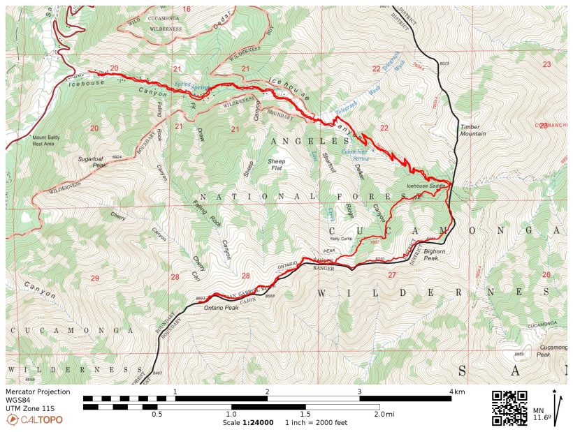
Route: Follow the Icehouse Canyon trail up to Icehouse Saddle. Next, take the Ontario Peak trail to the summit. On the way back, stick to the ridge and ascend to Bighorn Peak. Continue down the ridge to the Icehouse Saddle and rejoin the maintained trail to return to the trailhead.
Permits & Regulations: A free wilderness permit is required to hike the trail past the Cucamonga Wilderness boundary (a few miles up Icehouse Canyon). They can be obtained at a brown box at the trailhead or at the Mt. Baldy Visitor Center (open weekends only) a quarter-mile away. Perhaps the most pressing logistical detail to consider is parking at the Icehouse Canyon trailhead. An Adventure Pass (or equivalent interagency pass) is required to park at the lot, which fills to capacity very early on weekend mornings.
Resources: As far as maps go, I recommend the Tom Harrison topo map of the Cucamonga Wilderness for this hike. Check the National Forest page for the trailhead to learn about current notices and alerts. Finally, since this route is a popular one, take care to leave no trace!
A February Heat Wave
13 Feb, 2022 | 11.5 mi | +/- 3900 ft | View on Map
I roll into the parking lot at about 7:15 and am surprised to find it only half full. It’s usually packed on the weekend! Today is Super Bowl Sunday though, so perhaps people are staying home to watch the game (although it doesn’t start until 3:30 PM… plenty of time for a hike!). As I lift my backpack out of the car I’m tempted to leave the crampons and ice axe behind. There wasn’t any snow on the drive up, just a few patches high up on the mountainsides. Also, it’s already in the mid-50’s, so I’m skeptical that the snow will be very icy, even a few thousand feet up. Glancing around at the other hikers in the parking lot, I don’t see anyone else with technical gear… just small backpacks, trail runners, and the occasional pair of hiking boots. I wonder if the other hikers know something I don’t? A trip report from only two days ago described icy conditions, but maybe things have softened up. In the end I decide to take the crampons and ice axe; the worst case scenario is I carry a few extra pounds up the mountain.
The trail begins across the street from the trailhead. I pause for a minute to take a picture for a hiking group and then hurry down the trail. I keep my hands in my pockets for a while as I stroll through the crisp air beside the creek. It doesn’t take long to leave those signs of civilization behind though, and I’m soon within the Cucamonga Wilderness.


As I progress further and further up the trail I encounter ever-larger patches of snow. I’m surprised to find it frozen solid despite the relatively warm morning temperatures. It’s been over 80 for several days, but somehow this shaded canyon has held on to a considerable amount of snow! Although I felt foolish and over-prepared at the trailhead, I now think I’ve made the right call.
By the time I begin climbing the switchbacks up to the Icehouse Saddle, snow covers the entire trail. Even frozen solid, there’s enough dirt and debris on top to provide traction and I don’t put microspikes on until I’m about half a mile below the saddle. They’re not really “necessary” since the slope is minimal but they’re easy to put on and I prefer having the sure footing.

The saddle itself is a patchwork of bare dirt and shaded snow. I sit down on some dry pine needles and munch on snacks for a few minutes while examining the map. I’ll be heading southwest from here, contouring up and across the ridge to Ontario Peak. From what I’ve been able to see on the hike up, the entire north-facing aspect that I’ll be traversing is completely shaded and covered in snow. It’s still early — 9 AM — so it’ll be a while before the sun rises high enough to soften the snow, which means no post-holing for me!
Once I’ve finished my snack and applied a layer of sunscreen, I shoulder my backpack and follow the boot track heading toward Ontario Peak. Judging by the scarcity of footprints, this isn’t a very well-traveled path. I make it about 100 feet down the trail before deciding that microspikes are not going to cut it. My feet don’t sink into the snow whatsoever, I’m just walking on an inclined sheet of ice. The slope below me drops rather steeply into the canyon below too; while a fall probably wouldn’t be deadly, I’m not really keen on sliding head-first into a tree. So I stop for a few minutes to put on gaiters and crampons. With the ice axe in hand, I continue along the slope. Even though the crampon teeth only sink a half centimeter into the icy crust, I feel much more secure.


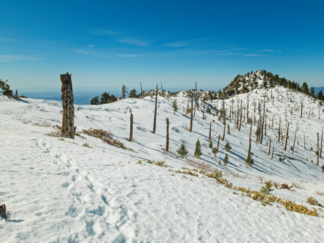
I thoroughly enjoy the next half hour of trekking through the wintry forest. In contrast to the Icehouse Canyon Trail, I’m the only person around and birds chirp noisily in the trees as I crunch by. The cool, shaded woods eventually give way to sunny slopes a few hundred feet below the ridge crest. I pause several times to remove layers and am soon sweating profusely as I struggle up the slope. Thankfully, the snow is still solid as can be and the crampons barely sink into the snow, even as I walk past massive post-holes left by previous hikers.
Since the snow remains firm and easy to walk on, I deviate from the established boot track. Rather than follow the footprints up every knoll and rise on the ridge, I contour around the hills at a relatively constant altitude. I’m certainly not the first person to do so – there are footprints here too, but many fewer than at the top of the ridge. For the most part, the final mile or two to Ontario Peak remains level and provides sweeping views from Cucamonga Peak to Mount Baldy. From the scattered, blackened tree trunks and abundance of young saplings, I suspect a recent wildfire is to blame for the stellar vista.


 as I trek across the ridge")


By the time 11:00 rolls around, I’m standing atop Ontario Peak! There’s not much here beside a gnarled tree, a summit sign, the summit register, and a deformed bottle opener. As I dig through my food bag I realize I haven’t really brought enough snacks… an apple, a granola bar, and a bag of trail mix are all that remain. It’ll be enough, particularly since it’s mostly downhill from here, but I wish I had brought something more substantial.

Rather than descending the same way as I came up, I follow the ridge toward Bighorn Peak. I’m once again grateful for the crampons as I traverse beneath a rocky outcropping on a steep, icy slope. The snow is so solid here that I have to put some force into my footsteps to get the crampon teeth to hold. It’s an exhilarating hundred feet that requires some concentration – only the uphill side of each crampon is even touching the slope! The excitement doesn’t last long though, and I’m soon strolling along gentler terrain.
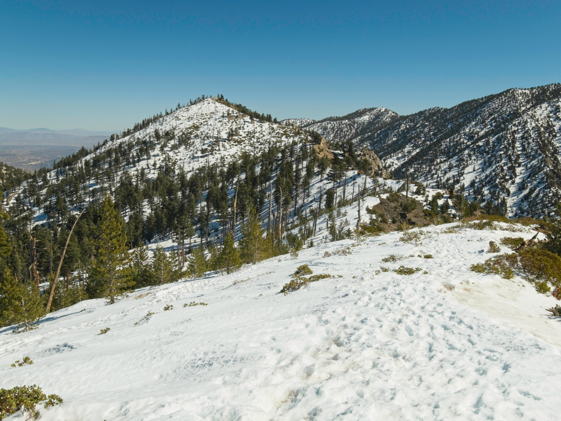
The final climb up to Bighorn Peak proves much more difficult than I expected. I think the elevation is to blame, even if it’s only just above 8000 feet. In any case, after much huffing and puffing, I reach the top at about 12:30 and pause to chat with a few other hikers. Unlike the parking lot crowds, these folks are clearly outfitted for technical snow travel. A man about my age with an ice axe and crampons has just come from Cucamonga Peak and is one his way over to Ontario. Two women with snowshoes and microspikes are relaxing on a snow bench they’ve dug. They’re clearly having a great time with beers nestled into the snow and finger sandwiches laid out in front of them!
I thoroughly enjoy the descent from Bighorn Peak to Icehouse Saddle. My gaiters really earn their keep as I plunge step up to my knees through sugary snow. I keep the crampons on for the descent from Icehouse Saddle, speeding past hikers cautiously navigating the icy trail in their trail runners. Once the snow begins to dwindle, I plop down, remove the crampons, and swap my ice axe out for trekking poles. The rest of the descent speeds by, but isn’t as fun or as beautiful as the ascent this morning. My feet ache from wearing crampons all day, and the constant downhill isn’t easy on my knees. I’m glad to reach the car at 2:20 where I slip into comfier sandals and thoroughly stretch out my tired legs.
If I learned anything today, it’s to trust my judgement and not second-guess myself based on what other hikers are carrying. Today’s hike would not have been nearly as safe or enjoyable had I left the crampons and ice axe behind. Also, it was really rewarding to make a plan, bring the appropriate gear, and then use all of it! I’m looking forward to more winter adventures; here’s to hoping for more snow and more beautiful, sunny days.