Cucamonga Peak is one of many summits in the Cucamonga Wilderness accessible from the Icehouse Canyon trail. While the hike is not terribly long – about 6-miles, one way – the elevation gain of 4,200 feet is taxing. Many hikers complete the out-and-back route from Icehouse Canyon to Cucamonga Peak as a day hike. However, as I hadn’t been camping in a while, I thought it would be fun to watch the sun set from the summit, spend the night, and then watch the sun rise in the morning. With this simple plan in mind, I recruited a few coworkers and went backpacking.
Trip Planning
Specs: 11.5 mi | +/- 4400′ | 1 day, 1 night
Difficulty: Class 1 [learn more]
Location: San Bernardino National Forest | Home of the Kizh and Tongva peoples | View on Map
Route: Begin at the Icehouse Canyon Trailhead and head up Icehouse Canyon to the saddle, then continue up to the summit!
Permits and Regulations: Perhaps the most pressing logistical detail to consider is parking at the Icehouse Canyon trailhead. An Adventure Pass (or equivalent interagency pass) is required to park at the lot, which fills to capacity very early on weekend mornings. Additionally, a self-issued permit (available from a box at the trailhead) is required for the hike. If you plan to use a stove (campfires are prohibited), you’ll need an additional campfire permit, available online.
Resources: As far as maps go, I recommend the Tom Harrison topo map of the Cucamonga Wilderness for this hike. Finally, since this route is a popular one, take care to leave no trace!
Icehouse Canyon to Cucamonga Peak
June 22, 2018 | 5.75 mi | +4200′ / -200′ | View on Map
Thanks to our wonderful 9/80 work schedule, David, Coco, Nihal and I don’t have work on Friday and decide to begin our hike on our day off rather than fight the crowds on Saturday morning. As the route to Cucamonga Peak is less than 6-miles, we begin later in the day (at noon) to avoid excessive amounts of time spent lounging around camp. The downside of this plan is that the temperature is already climbing into the 80’s when we begin our hike and we have lots of elevation gain ahead of us.
The trail begins in the shaded Icehouse Canyon, weaving between cabins very similar to those in the Santa Anita Canyon. While hiking through the canyon we gain elevation relatively slowly, a good warm-up for the climbs to come. We soon leave the cool confines of the lower canyon and begin a more aggressive ascent on dusty, rock-strewn trail.


Mid-way through the climb to Icehouse Saddle, we stop at the last water source available on this route: a small spring gushing from the rocks below the trail. We’re prepared for dry camping with several liters of water carrying capacity each, and we all tank up while we can. The water is cold and refreshing, so I soak my hat before leaving for some extra head refrigeration. From the spring, we continue up numerous switchbacks to the Icehouse Canyon saddle. The route is steep at times, and my calves burn as I climb. At the saddle, we enjoy a break beneath the shade of the tall conifers.


Many trails lead away from Icehouse Saddle; our route continues south and west toward Cucamonga Peak. Although we still have at least 1,000 feet to climb, we find ourselves descending as we contour along the east side of Bighorn Mountain. The downhill slope provides a nice change of pace, but we’re all well aware that we have to regain every single downward step to reach the summit of Cucamonga.


After descending a bit, the trail climbs once more, switching back to a saddle between Bighorn Mountain and Cucamonga Peak. From this saddle, we begin the final climb. Initially, we ascend switchbacks through large scree fields, the stones clinking and clattering as our feet disrupt their equilibrium. The scree fields don’t last long, however, and we’re soon kicking up dust on a more conventional path.


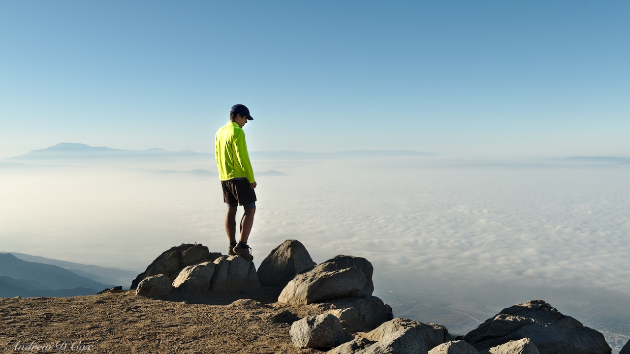
Although we pause many times to catch our breath and gulp down some water during the hot, dusty ascent, we eventually reach the summit. Other than a nice couple already enjoying the views, we’re the only hikers up here! The relative solitude and quiet evening air are well worth the arduous climb. We find several summit signs atop various rocks, both at the true summit and below it, and take a few photos with them to commemorate our achievement.


With all the hard work done and over with, we’re happy to drop our packs and relax for a while. Coco brought a book and sits reading on a rock overlooking the San Bernardino valley. David and Nihal locate the summit register and spend some time flipping through the pages and reading previous hikers’ comments. The sun dips lower and lower on the horizon while we unwind, and the shadow of the mountain stretches further and further across the valley below.


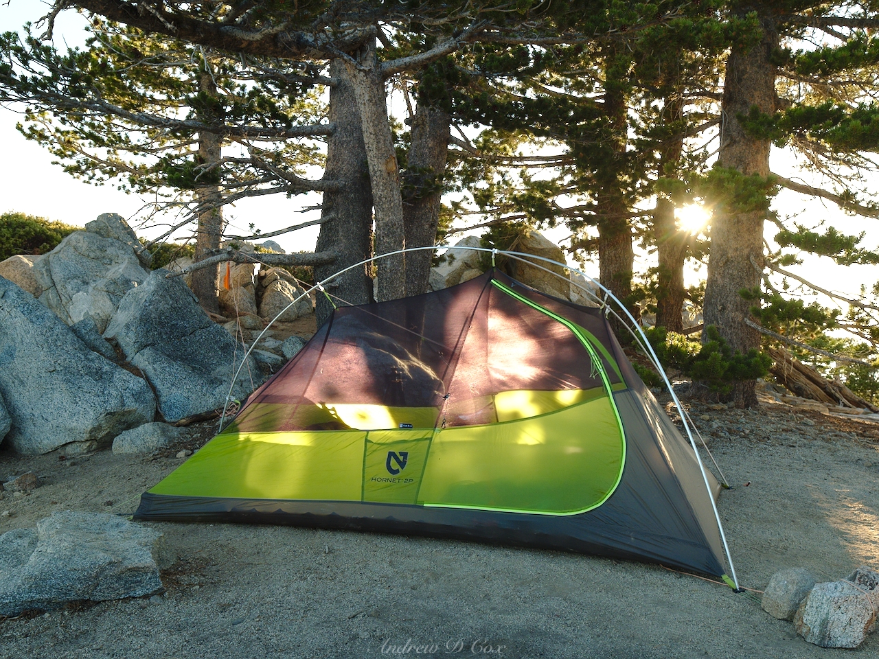
With waning daylight, we set up our tents and cook/eat some dinner. The summit of Cucamonga Peak supplies tons of fantastic campsites, some beneath trees, others out in the open among rocks and chaparral. Coco and I set up our tent near a small stand of pines while David and Nihal opt for a spot with more expansive views.
We spend the rest of the evening watching the sun set. Both David and I are photography enthusiasts, so we take advantage of this final hour before sunset (i.e., the “golden hour”) to capture some shots of the scenery. I packed my tripod and some Formatt Hitech filters to play with but – at some point during the hike up to the summit – the tripod ballhead fell off. I can still use the tripod by screwing the camera directly onto the center post, but the setup is less than ideal.
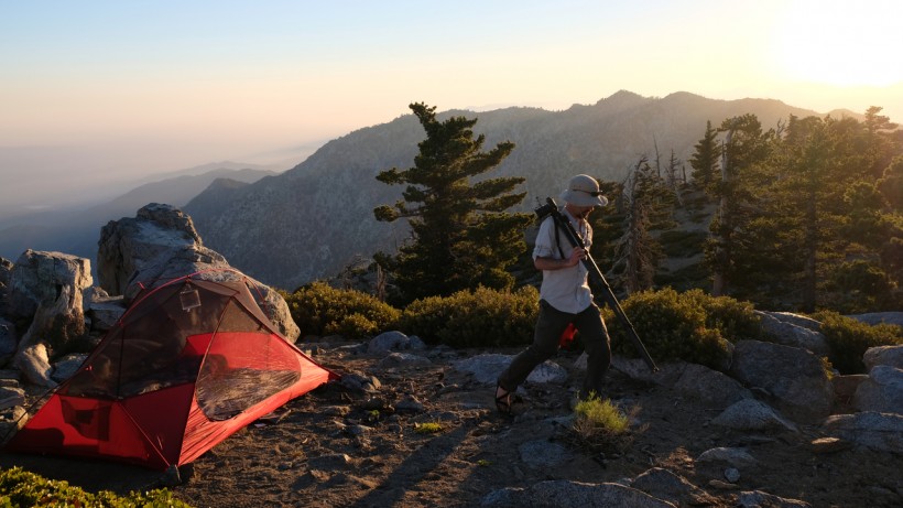
Regardless, I’m determined to do some photography and I wander off to find a view of the ridge between Ontario and Bighorn peaks.

David, Coco, and Nihal remain closer to camp and enjoy views as well.
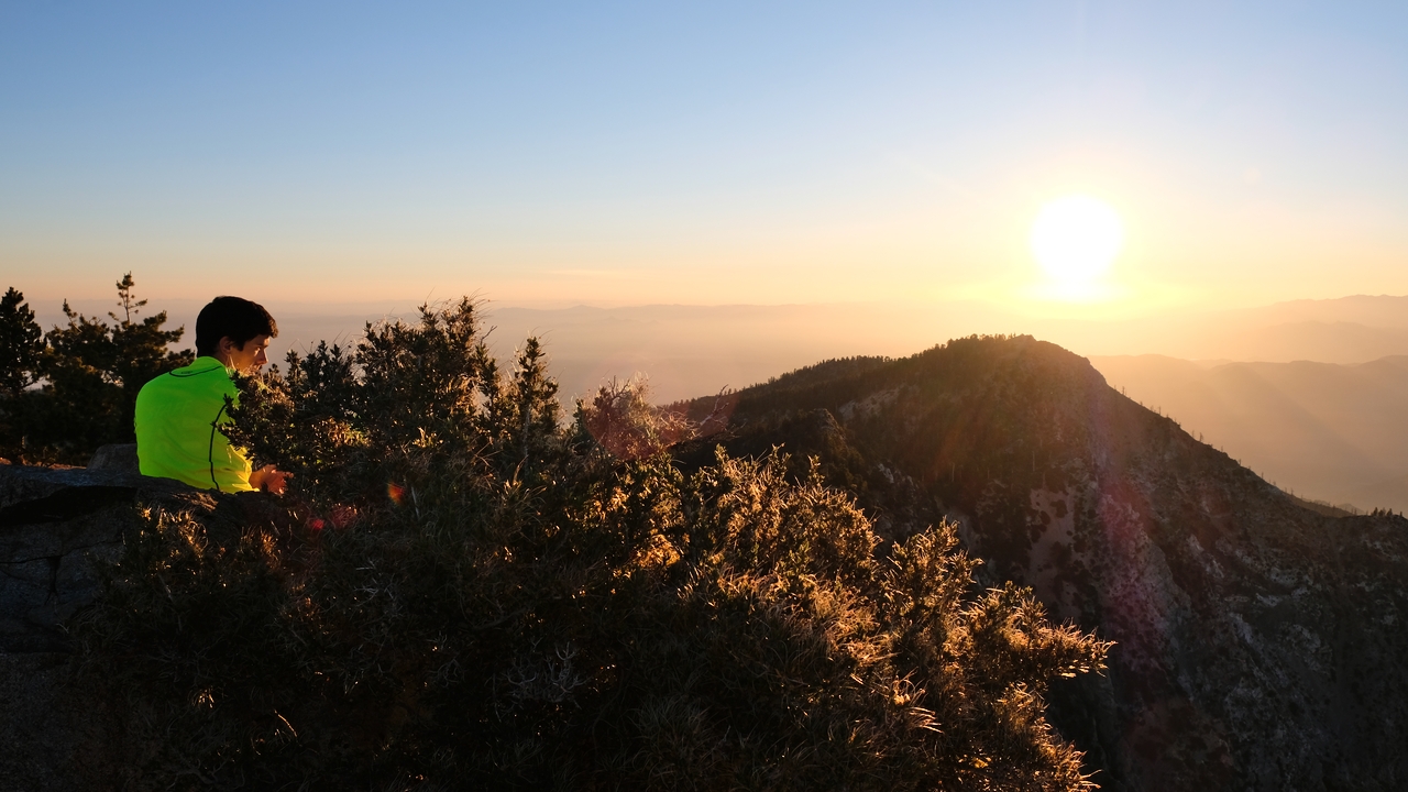
Once the sun has dropped below the horizon, I return to camp and chat with the others as darkness falls. The city lights twinkle in the valley below and a few stars appear above us. Tired from the day, we soon say goodnight and go to bed.
Descent from Cucamonga Peak
June 23, 2018 | 5.75 mi | +200′ / -4200′ | View on Map
I don’t sleep well at all – I don’t really know why, because the night is quiet and cool, and I’m perfectly comfortable in my sleeping bag. My only hypothesis is that the extraordinarily bright moon overhead keeps me from falling asleep. I left the rainfly off of the tent, both for air circulation and to create a feeling of openness, and the moonlight shines directly onto my face for several hours. I do manage a few hours of peaceful sleep, however, and get up early to watch the sunrise; it’s not every day that I’m lucky enough to be camped on the top of a mountain!

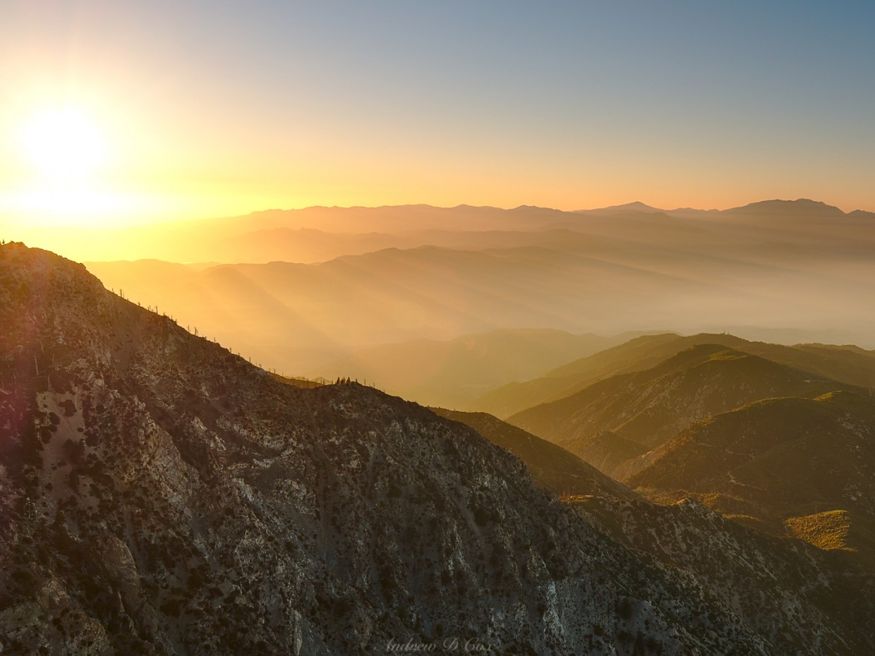
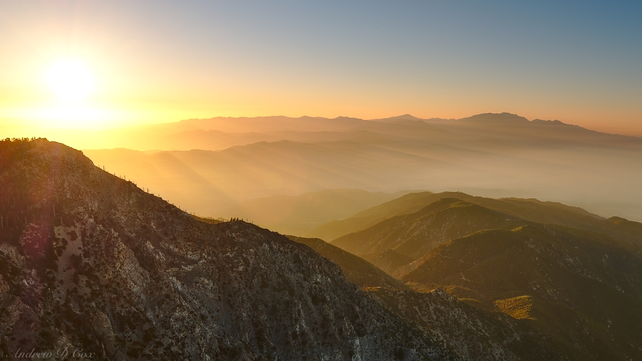
David, Nihal, and Coco also get up to admire the morning views. As the sky brightens, I’m incredibly excited to discover that the entire valley below us is covered in a layer of clouds. While the population of San Bernardino rises to a dreary Saturday morning, we get to admire a colorful sunrise! Gray clouds or blinding sunlight? It’s really just a matter of perspective.

As the sun climbs higher into the sky its rays stream through the mountains and low-hanging clouds, creating crepuscular rays in every direction. I awkwardly adjust my head-less tripod to capture the views. Despite the diffulty, I’m very happy with the results!
After an hour or so, the warm morning light cools to its usual daytime hue and we stir from our seats to go make breakfast and pack up camp. I enjoy some oatmeal, Coco munches on a savory cake he baked a few nights ago, David slowly consumes a Clif Bar, and Nihal finishes off the last of his PB&J sandwiches. After eating and breaking down camp, we begin the downhill trek back toward civilization.
The return journey from the summit is much easier than the ascent and we cover ground at nearly twice the pace as yesterday. During the first few miles to the saddle between Bighorn and Cucamonga Peaks, we pass a few hikers making their way to the summit. Further down the trail, on the other hand, we pass dozens and dozens of people. Although the descent is just as long and steep as our climb yesterday, it isn’t particularly hard on the knees, perhaps because we’re forced to stop and let groups of ascending hikers pass every few minutes. I’m glad that we chose to begin our hike yesterday and avoided the crowds!
The final few miles to the trailhead pass quickly and we soon find ourselves back at the trailhead. The parking lot and all neighboring streets are packed with cars; some lucky hiker snags our parking spot as we drive off in search of hot food and coffee.
Felix 18 July 2019
Hey! Insightful stuff , appreciate it. Did you have to obtain permit to camp at the top? And do you know if dogs are allowed. Thanks man
Andrew Cox 18 July 2019 — Post Author
Thanks, Felix. At the time, the hiking/camping permit was free and self-issued at the trailhead. I’m not sure about dogs, but I bet the rangers at the Baldy Ranger Station will know!