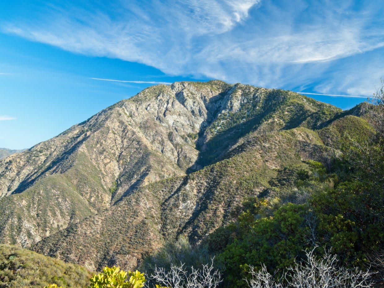
According to crowd-sourced opinions, Iron Mountain is one of the toughest hikes in the San Gabriel Mountains. Although no technical skills are required to reach the summit, you’ll need a fair amount of endurance to push through the muscle-burning 6000-foot ascent. Bring plenty of water and sunscreen too – there’s very little shade! That being said, I’d recommend this hike to any serious hiker that wants a challenge. The views are lovely and you’re treated to much more solitude than most trails around L.A.
Trip Planning
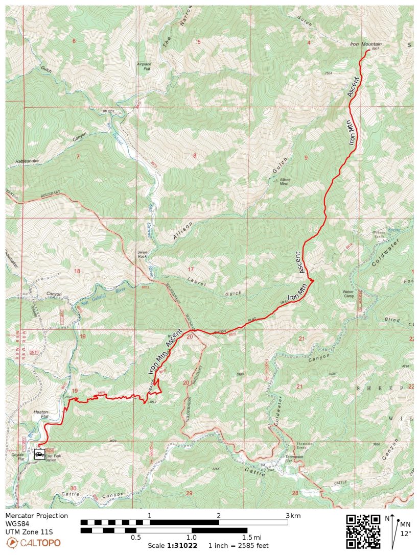
Specs: 13.7 mi | +/- 6100 ft (these specs are from my GPS track; CalTopo measures this route at 13.1 miles and +/- 7300 ft)
Difficulty: Class 1 [learn more]
Location: Angeles National Forest | Home of the Kizh and Tongva peoples | View on Map
Route: Follow the (dirt) road from the East Fork parking area to the campground. The Heaton Flats Trail begins behind the pit latrine, climbing up to a saddle in the ridge to the east. The trail continues along the ridgeline, undulating up and down for a few miles to Allison Saddle (the intersecting trails there are very overgrown and faint). From Allison Saddle, climb up the steep south ridge to the summit of Iron Mountain via a well-worn use trail.
Permits & Regulations: You can fill out a self-issued permit at the East Fork parking area, but permitting doesn’t appear to be enforced. There is a $5 fee for parking, however (an Adventure Pass or equivalent Inter-agency Pass will also suffice). Because the latter portion of this trail is not officially maintained, take extra care to leave no trace!
Resources: Check the Heaton Flats Trailhead USFS page and related Angeles National Forest links for current information about closures, fire risk, etc.
An Impromptu Day Hike
20 Nov, 2021 | 13.7 mi | +/- 6100 ft | View on Map
I’m always amazed at how fast the East Fork parking lot fills up. I arrive at 7:20, sure I’m going to snag a spot, but end up parking on the side of the road behind a long line of other “late” arrivals. Thankfully, the shoulder is wide and flat and it only takes me a minute or two to walk to the parking lot.
After declining a solicitation to bungee jump off of the Bridge to Nowhere, I stroll down a dirt road to the Heaton Flats campground. A large sign beside the pit latrine marks the beginning of the trail, so up I go. With the sun still on the other side of the ridge, I keep my jacket on for a while as I work up the switchbacks. I pause once to photograph a few colorful sycamore trees but otherwise continue uninterrupted, leaving the noisy campground and popular Bridge to Nowhere trail behind.


Beyond the saddle, the trail follows a few more switchbacks to gain the ridgetop itself and then stays there, gaining and losing altitude with the many “bumps” in the ridge. Manzanita, scrub oak, and yucca line the trail, the latter of which I’m very careful to avoid; even a relatively soft tap against a needle-tipped yucca frond can draw blood. As I stroll along the trail I notice several large piles of scat peppered with manzanita fruit. A few minutes later I spy a fresh print in the soft dirt, confirming my suspicion: a black bear has been feasting on the manzanita up here, probably even this morning! I continue on, talking loudly to myself and singing “Meet the Flintstones” (the first song that popped into my head) so that I don’t surprise the bear in some dense thicket of brush.


About two hours after leaving the parking lot I arrive at Allison Saddle. I groan when I pull out the GPS and see that I’m still 3400 feet below the summit but only 2.5 miles away; this is going to be a steep one. Thankfully, the steepness comes in spurts; a few hundred feet here, a few hundred feet there, interspersed with gentler slopes and even some shady spots! To be honest, besides the steep grade, it’s really a pretty nice trail. The ground is firm, there are plenty of rocks to provide traction, and the views only get better as I gain altitude. As I struggle up the mountain I meet a few other hikers on their way down, but otherwise have the trail entirely to myself.
My legs are burning by the time I reach the summit at 11:50, so I take a nice long break. A lone raven trills and clicks from a nearby tree as I sit and admire the views. Mount San Antonio, a.k.a., Baldy, rises just to the east. If you don’t mind another two or three thousand feet of elevation gain, you can traverse the ridge between Iron Mountain and Baldy and then descend to the Manker Flat trailhead. It sounds like a neat hike, but I can’t imagine asking my body to do that much more work at the moment.


After resting for a few minutes, I sign my name in the register, say goodbye to the raven, and begin the 6000-foot descent back to the car. I’m very grateful to have trekking poles, particularly during the steep, 3400-foot drop between the summit and Allison Saddle. Time slips quietly by as I walk along the roller coaster of a ridge, which I find much more pleasant this time around. Although there’s little shade, it’s really not too hot this afternoon; a cool breeze wafts by intermittently, and, well, it is mid-November.

A few weary hours later, I arrive back at the Heaton Flats Trailhead (and campground). A short walk back up the access road brings me to my car at 3:30 PM. After a little stretching, I toss my dusty bag into the back seat and drive off in search of ice cream.