In my slow march toward hiking up all the Eastern Sierra trails, I grabbed a permit for the Convict Creek trail this spring. Located just north and west of McGee Creek, Convict Creek sports the same swirling marble formations and is home to some of the oldest rock in the Sierra. I invited a few friends to come along on this trip since the approach to the “good stuff” – the alpine lakes – isn’t very long and makes for a great relaxing weekend trip.
Trip Planning
Specs: 23.9 mi | +/- 9100 ft | 3 days, 2 nights
Difficulty: The hiking is mostly class 1, with one slightly spicy creek crossing. The routes to Bloody Mountain and Mt Baldwin include some class 2 terrain [ratings].
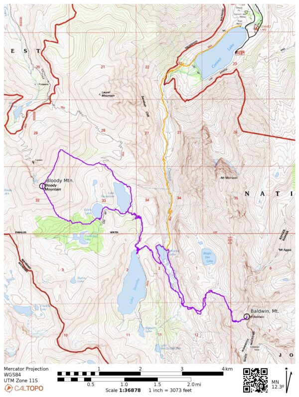
Location: Inyo National Forest, California | Home of Eastern Mono/Monache and Northern Paiute peoples | View on Map
Route: Begin at the Convict Lake boat ramp and hike around the north side of the lake. The trail heads up the canyon for a few miles, crossing the creek once, to Mildred Lake.
- Bloody Mountain: I followed the trail from Mildred Lake to Lake Genevieve. The map shows a trail continuing around the east side of Genevieve, but it’s faint at best, so I mostly made my own way to the east side of Bloody Mountain’s north ridge. To save some miles, I ascended directly up a chute in the ridge instead of continuing up the trail to the saddle between Laurel and Bloody. A well-established use trail leads all the way up the ridge to the summit. For the descent, I made my way down the loose slate on the south face and then hiked cross country back to Lake Genevieve.
- Mount Baldwin: From Mildred Lake, hike south along the east side of the marshy meadows to a creek that flows down from Mount Baldwin. Plentiful cairns guide you up the drainage to desolate limestone cliffs. A well-traveled use trail leads to the summit.
Permits & Regulations: Permits are required for overnight travel and food must be stored in bear-proof containers or counter balanced. See the trailhead page for more information. As always, take care to leave no trace!
Resources: I relied on the National Geographic Mammoth Lakes & Mono Divide map for navigation on this trip, with some help from the Gaia GPS app. The Forest Service website is also a great resource for current information.
Convict Canyon
26 July 2024 | 4.75 mi | +2300 / -100 ft | View on Map
Kenza, Jesse, and I arrive at Convict Lake in the early afternoon and we meet Margaret at the trailhead. After some re-shuffling of gear, we’re on our way down the trail that circumnavigates Convict Lake. It’s a warm day and there are dozens of people lounging, fishing, and swimming in the shallows, plus a bunch of boats puttering around the lake. We pass a ton of day hikers in the first mile, but as soon as we step away from the loop trail we’re treated to solitude.


One of my favorite things about this part of the Sierra is the colorful and complex geology. Most of the Sierra are part of a granite batholith that has been uplifted over the millennia. But the colorful, reddish, swirling rocks are part of a metamorphic roof pendant that long predates the formation of the granite. If you’re interested in reading more, I found a fascinating geologic map of the area by James F. Davis. There’s also this much-cited study by Rinehart and Ross, “Geology and mineral deposits of the Mount Morrison quadrangle, Sierra Nevada, California” (1964).


We slowly make our way up the trail, admiring the rocks and Convict Creek along the way. About 3.5 miles into the hike we reach a creek crossing where crumbling cement foundations mark the location of the old bridge. Thankfully there isn’t too much water so walking through the creek isn’t dangerous. It is very cold, though! Jesse and I cross barefoot and Kenza and Margaret slosh through in sandals.

There are only a few miles left after the creek crossing. We pass lots of pretty wildflowers on the way up to Mildred Lake, including columbines, mountain coyote mint, indian paintbrush, and some very colorful anderson’s thistles.


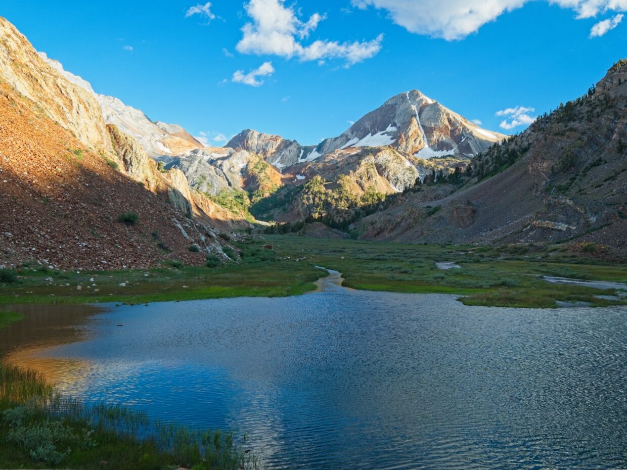
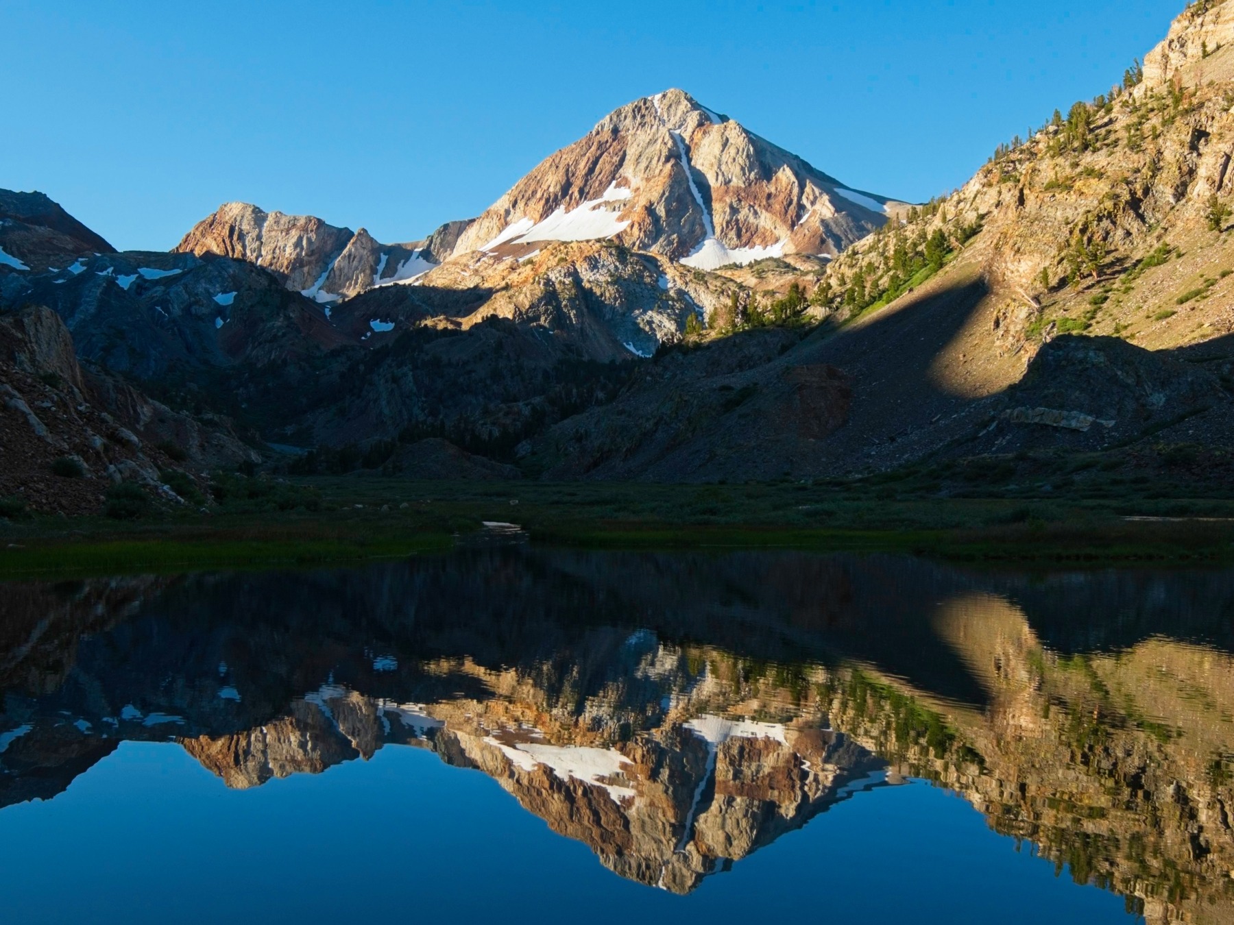
By the time we reach Mildred Lake, the sun is low in the sky and we’re treated to beautiful, warm light. Although my original plan was to continue up to Lake Dorothy, I’m more than happy to stop at Mildred Lake. The view of Red Slate Mountain is phenomenal and we’re all much too tired to hike for another hour. We set up our tents in a sandy draw below the lake and relax for the rest of the evening.


Bloody Mountain and Mt Baldwin
27 July 2024 | 14.4 mi | +/- 6700 ft | View on Map
Gusty winds buffeted our campsite all night and I barely slept. Not only was the wind noisy, but I had to get up a few times to re-stake-out my tent when the thin stakes pulled out of the sand. Morning brings slightly less wind but very chilly temperatures. I don’t really want to get up, but I know I’ll feel better with some warm food.
Our plans for today vary from person to person. Margaret brought a book and is looking forward to sitting by a lake and reading, Jesse and Kenza are excited to do a hike to some of the nearby lakes, and I’m hoping to summit both Bloody Mountain and Mount Baldwin. Jesse, Kenza, and I leave camp a little before 7:30 while Margaret catches up on sleep now that the wind has subsided.
The path to the higher lakes first loops around the bottom of Mildred Lake and then follows a long, diagonal line up the ridge to Lake Dorothy. It’s pretty easy walking, but I can definitely feel the 10,000-foot elevation. We pause for a few minutes at Lake Dorothy to admire the view and then continue up the trail to a ridge overlooking Lake Genevieve and Bloody Mountain. I can see right away how the mountain got it’s name; the slate is decidedly blood-colored.


I leave Kenza and Jesse at Lake Genevieve and trek around the eastern shore. I try to follow a use trail at the water level but have to scramble up higher to get around some cliffs. There’s supposed to be a use trail all the way around this lake and over the saddle between Bloody and Laurel, but it’s faint at best, so I don’t try too hard to find it or stay on it when it is visible. Instead, I just trek cross country toward the north ridge of Bloody Mountain. I intend to hike up the “obvious gully” Secor describes on the east side of the ridge and his description is spot on; it is very obvious, particularly from far away.


Hiking up the gully ends up being a tedious affair since the ground is covered in loose slate scree. I stick to protruding rock bands when I can, but am often forced to slip and slide through the plates. Thankfully, once I reach the ridge top I find a well-traveled use trail that leads all the way to the top. It’s fairly flat too, and makes for an relaxing walk after the loose scree.


I spend a few minutes on top of Bloody Mountain, admiring the vista, and then begin my descent. There are a few options, the most obvious of which is to retrace my steps. That’s not the most direct route, however, and I’m not very excited to descend that slate scree. One of the more direct options is to hike down the south face of the mountain (which is also loose slate, to be fair) toward Cloverleaf Lake and then hike cross country back to Genevieve. The only real way to avoid the scree is to hike all the way down to the saddle below Laurel Mountain, which adds miles to the walk. So I decide to take the direct route down the south face.
Despite taking extra care on the south face of Bloody Mountain, I slip and fall a few times on the loose rocks. It’s not a fun descent, but it’s also over within 30 – 40 minutes. Then I’m able to scramble down granite slabs and through pine forests, which is much nicer. I cross the Edith Lake inlet and then follow the established trail to Genevieve, back up several hundred feet of switchbacks, and across the ridge to Lake Dorothy. It’s high time for lunch and I find Margaret reading by the lake, so I pop over to chat with her while I eat.
After a quick lunch, I hike back to Mildred Lake and then begin hiking up the edge of the marshy valley toward Red Slate Mountain. I’m on the west side of the valley, which is definitely not where most people hike, but there’s enough easy talus and dry grass to progress without getting my feet wet.


Midway up the valley I hop over several branches of Convict Creek and cross to the east side where a small creek flows down from Mount Baldwin. I say hello to a couple of hikers that are resting at the bottom of the hill and then follow the plentiful cairns up the creek. The hiking here is much nicer than on Bloody Mountain. Instead of loose plates of clinking slate, Mount Baldwin seems to be one massive block of marble. I happily walk up the slabs and over a few sandy plateaus, following intermittent cairns and faint use trails.


Up higher on the mountain I find a use trail that leads all the way to the summit. I pass a few descending hikers and pause several times to look at huge bands of calcite crystals. There are some old tools near the upper most calcite outcropping, commonly known as the “calcite mine” or the “Bausch & Lomb Mine.” These crystals are apparently useful in optics and were at least investigated as such a long time ago [Evans B. Mayo, “Geology and Mineral Deposits of Laurel and Convict Basins, Southwestern Mono County, California,” California Division of Mines Report 30, pp. 79-88, 1934].


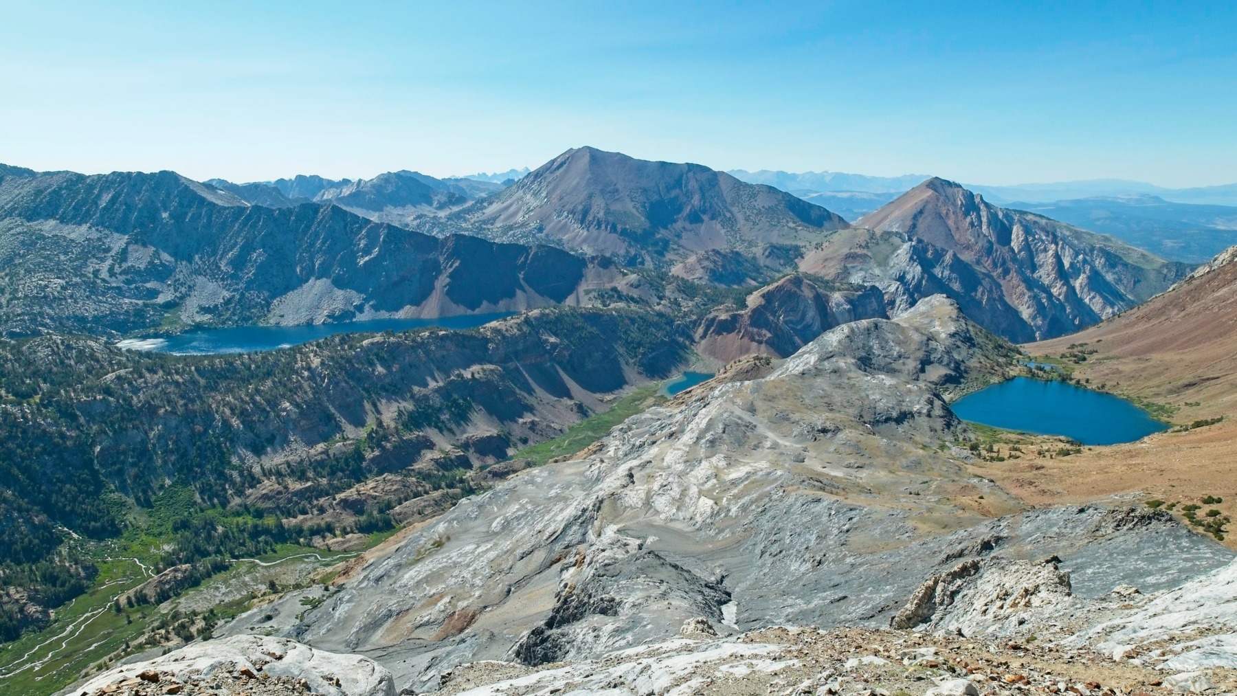
The final 500 feet to the summit of Mount Baldwin really wear me out. It’s all I can do to stagger up the sand and slabs, pausing every 10 seconds for a break. I rest for a long time up top, eating snacks and staring out at the valleys below. Mildred Lake is only half visible, with Lake Dorothy barely contained by the ridge; it looks like it might spill over and flood the valley at any moment. I can see Bloody Mountain across the valley too, but it seems very far away now.
After resting for a while, I hurry down Mount Baldwin. I enjoy plunge-stepping through the sand and quickly descend the use trail back to the meadow. From there, it’s easy walking through the grass. The sun is already well below the ridge, so it’s cool in the valley and the soft ground is a welcome break from all the rocky terrain.

I reach camp a little before 7 PM and happily sit down for dinner. Everyone else is already back, so we trade stories. Margaret had a pleasant day reading her book and Jesse and Kenza visited a whole bunch of lakes and swam in a few of them! And I managed to tag both of the peaks I had planned to, even if it did take the entire day.
Hiking Out
28 July 2024 | 4.75 mi | +100 / -2300 ft | View on Map
This morning is even chillier than yesterday was, so I keep my puffy on for quite a while. We eat breakfast, pack up camp, and hit the trail at about 8:00. It’s almost entirely a downhill walk this morning, so it doesn’t take us long to reach the lower section of the canyon and warmer temperatures. In fact, by the time we reach the trailhead, it’s downright hot. Our cars are parked right next to the lake, so we decide to jump in to cool off before we leave. The water is a great temperature for a post-hike swim: icy enough to be refreshing but not so cold to be painful. We lounge in the water for a while, air-dry in the sun, and then drive into town for a big lunch. All in all, a very nice weekend in the mountains!


Diane 17 October 2024
Hi Andrew
Thanks for the description and photos of a wonderful part of the Sierras that I have yet to visit ! Your photos are (as always) astoundingly beautiful.
Diane in Kamloops
Andrew 17 October 2024 — Post Author
Thank you!