My move to California this summer coincided with the departure of one of my backpacking buddies, Daniel. He’s off to the east coast, but we managed to meet up for an exciting day hike to Strawberry Peak, the tallest front range peak (6,146 ft) in the San Gabriel Mountains, before he left. The hike was Daniel’s idea, and it was a ton of fun with some off-trail travel and class 3 scrambling! This route is now easily one of my favorite hikes in the LA area.
Trip Planning
Specs: 11.0 mi | +/- 4000 ft
Difficulty: Mostly class 1 with some class 2/3 problems during the ascent [learn more]
Location: Angeles National Forest | Home of the Kizh, Tongva, and Fernandeño Tataviam peoples | View on Map
Route: Begin at the Colby Canyon trailhead, following the nicely graded trail up into the hills. At Josephine Saddle (where you’ll find a large concrete cistern), follow the ridgeline climber’s trail up some steep washes and class 2/3 rocks to the flatter ridge west of Strawberry Peak. The trail is not always well-defined, here so you should be comfortable with route finding and cross-country travel. The final few hundred yards to the peak are entirely class 2 and 3 with some moderate exposure. From the summit, follow the heavily used trail down the eastern ridge to a distinct saddle between Strawberry Peak and Mount Lawlor. From this pass, follow the north-bound trail that leads toward Colby Ranch for about 1.5 miles to an open meadow with a creek flowing through it (the water dries up in the summer, but the wash is obvious). Take the trail that heads SW toward Strawberry Peak; this path eventually leads back to Josephine Saddle, where you rejoin the Colby Canyon trail and return to the trailhead.

Permits and Regulations: No permits are required for a day hike in Angeles National Forest, but you will need an Adventure Pass (or an equivalent inter-agency pass) to park at the trailhead.
Resources: I recommend visiting the Angeles National Forest Twitter feed to get the latest news and closures, particularly during the summer and fall when wildfires occur. Their website also has plenty of useful information, but can be a little difficult to navigate.
Trip Report
25 July, 2020 | 11.0 mi | +/- 4000 ft | View on Map
Daniel, Kate, and I meet up at the Colby Canyon Trailhead at 7:30. We’re hoping to get most of the strenuous, uphill hiking done in the cool, morning hours. The beginning of the hike is pleasant with a gentle grade, which gives us plenty of time and energy to catch up. I haven’t seen Daniel and Kate in nearly a year, so we have a lot to talk about! Time slips by as we walk up to Josephine Saddle, the intersection of several trails and the location of large concrete cistern. We scramble up to the top of it and enjoy a snack and some water with an excellent view of the surrounding peaks.


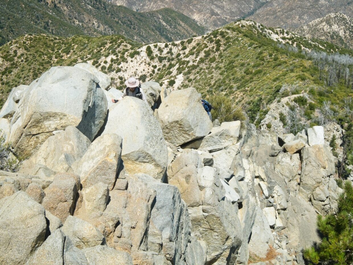
After a brief rest we leave the developed trail behind and begin the adventurous section of the hike! The path, more of a climber’s route than an established trail, is now much steeper more slippery; my calves burn as I struggle up the hill. After huffing and puffing up several steep gullies, the path reaches a large rock outcropping. I have a great time scrambling up the rocks, and the top offers some stellar views! We pause to take some photos, all three of us photographing each other.


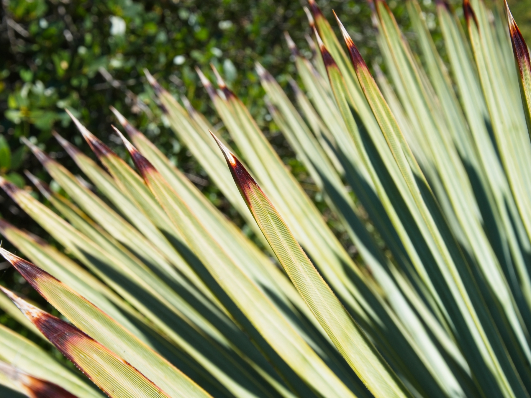
The next stretch of the hike is much flatter but full of a new obstacle: razor-sharp yucca plants. After accidentally brushing against the pointed leaves one too many times, we give them a new nickname: “torture bushes.” I do my best to avoid being stabbed as I wind my way across the flat ridge toward Strawberry Peak, but end up running into a few torture bushes anyway. Ouch!
As we near Strawberry Peak, we find ourselves confronted with a solid wall of dense chaparral. The steep slopes on either side of the ridge means there is only one way to the peak: through the bushes. Thankfully, there are a few use trails established among the thick foliage, but it’s still not an easy path. Low hanging branches and the occasional torture bush continue to slap and stab me as I push through the bushes.
After navigating the maze of bushes, we reach the final hurdle, a class 2/3 scramble up a few hundred feet of boulders. The first section consists mostly of boulder hopping, a familiar activity from my recent Sierra High Route trip. However, the slope soon steepens and we are obliged to use our hands and feet to scramble up through the rocks. A few moves along the way make me nervous with their moderate exposure — a fall would not be pleasant — but the climb is generally pretty straightforward.


The Strawberry Peak summit isn’t much to write home about, but does offer some nice views of the surrounding mountains. We document our ascent with a few photos of us holding the multitude of summit signs we find there. With the summit in the bag, we take a well-deserved rest, hiding from the sun in the shade of a few towering bushes while munching on snacks.


After relaxing in the shade for a while, we head back out into the hot sun and begin the second section of the hike. A brief downhill jaunt on a well-traveled trail leads us to a distinct saddle where we turn north, leaving all the other day hikers behind. The next several miles are pleasant enough but also terribly hot. There isn’t much shade, probably thanks to the 2009 Station fire that burned through this area; a few charred tree trunks remain as evidence of the wildfire.


My favorite part of the northern loop is a series of dusty meadows below the steep flanks of Strawberry Peak. (I’m sure they’re lush and beautiful in the springtime.) First of all, there’s (a little) shade! Second, the mountain is really impressive from this angle and makes me wonder if sheer northern face is climbable? (It is! 5 pitches of 5.9 trad.) Finally, we see a few deer grazing in the shade of the trees, and it’s always fun to see wildlife.
The last few miles back to the trailhead wear the three of us out. By the time we reach the cars, we’re out of water and anxious for some air conditioning and an ice cold beverage. Despite the toasty end to the hike, this route is easily now one of my favorites in the LA area. I love the off-trail and scrambling sections and am looking forward to returning in cooler weather.