In an attempt to motivate myself to leave the “safety” of my apartment during the pandemic, I decided to try to visit all of the peaks in the San Gabriel Mountains. There are dozens and dozens of them, some without any maintained trails, so I’m nowhere near completing this goal but I’m having fun crossing them off my list.
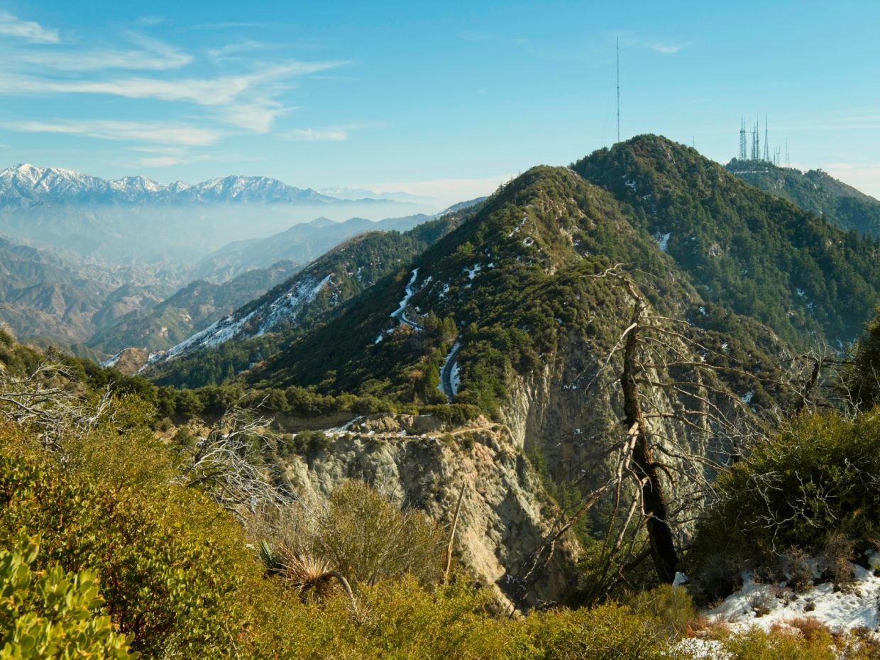
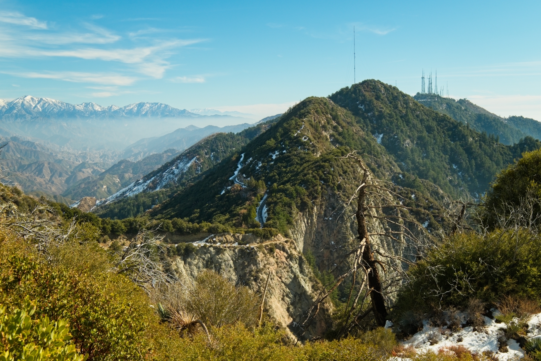
From the Red Box Gap you can easily reach a handful of peaks: Mount Deception, Mount Disappointment, San Gabriel Peak, Mount Markham, and Mount Lowe. You can also reach Occidental Peak and Mount Wilson via the paved road. The paths to each peak vary in ruggedness and difficulty. Mount Disappointment is the easiest and can be reached via the paved access road (it’s still 1300+ ft of elevation gain!). San Gabriel Peak and Mount Lowe are accessible via well-traveled trails. To reach Mount Deception, you’ll follow a faint use trail that can be steep and a little overgrown. Finally, the trail leading to the summit of Mount Markham is the most rugged with a few steep rocky sections (approaching class 2). Naturally, Markham is my favorite; the hike is hard but the views are really amazing!
Trip Planning
Specs: 10.8 miles | +/- 3500 ft | 3 January and 15 February, 2021
I visited these peaks in two separate trips.
Difficulty: Class 1 [Read more about difficulty ratings]
Location: Angeles National Forest | Home of the Kizh, Tongva, and Fernandeño Tataviam peoples | View on Map
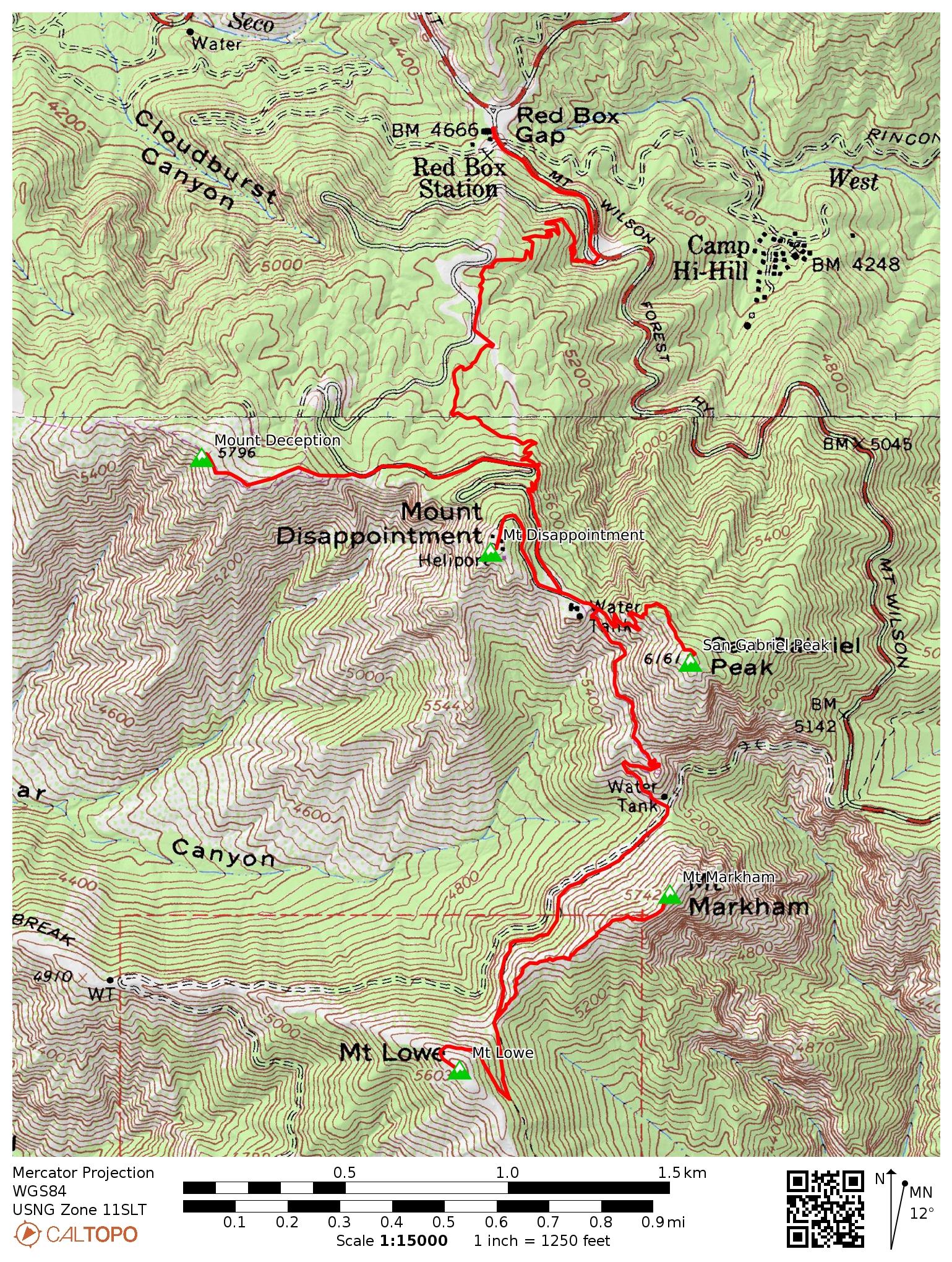
Route: This is one of many possible itineraries. Explore the map!
Begin at the Red Box Gap picnic area and follow the Mount Wilson Road for a little over 0.3 miles. Leave the road at the junction with the access road that leads up to Mount Disappointment; the trail begins here to the right of the uphill gully. The path passes by the access road several times on the way up to the ridge between Mount Disappointment and San Gabriel Peak. You can jut off to the west for a scramble up to Mount Deception (the faint use trail is steep but offers incredible views!). The trail eventually rejoins the access road just below Mount Disappointment; follow the road up to the radio-towers at the summit if you like, or head across the ridge to the trail to San Gabriel Peak. After tagging San Gabriel Peak, return to the trail junction on the ridge and descend to the saddle between San Gabriel Peak and Mount Markham. A trail leads from this saddle to Mount Lowe (don’t follow the fire road); a faint use trail leading to the summit of Mount Markham branches off from the main path at the saddle between Markham and Lowe.
Permits and Regulations: An Adventure Pass or equivalent interagency pass is required to park at the trailhead or on the road near the trailhead. Otherwise, just practice leave no trace and enjoy the national forest!
Resources: Check the Angeles National Forest website for current alerts, warnings, and restrictions
San Gabriel Peak Trail
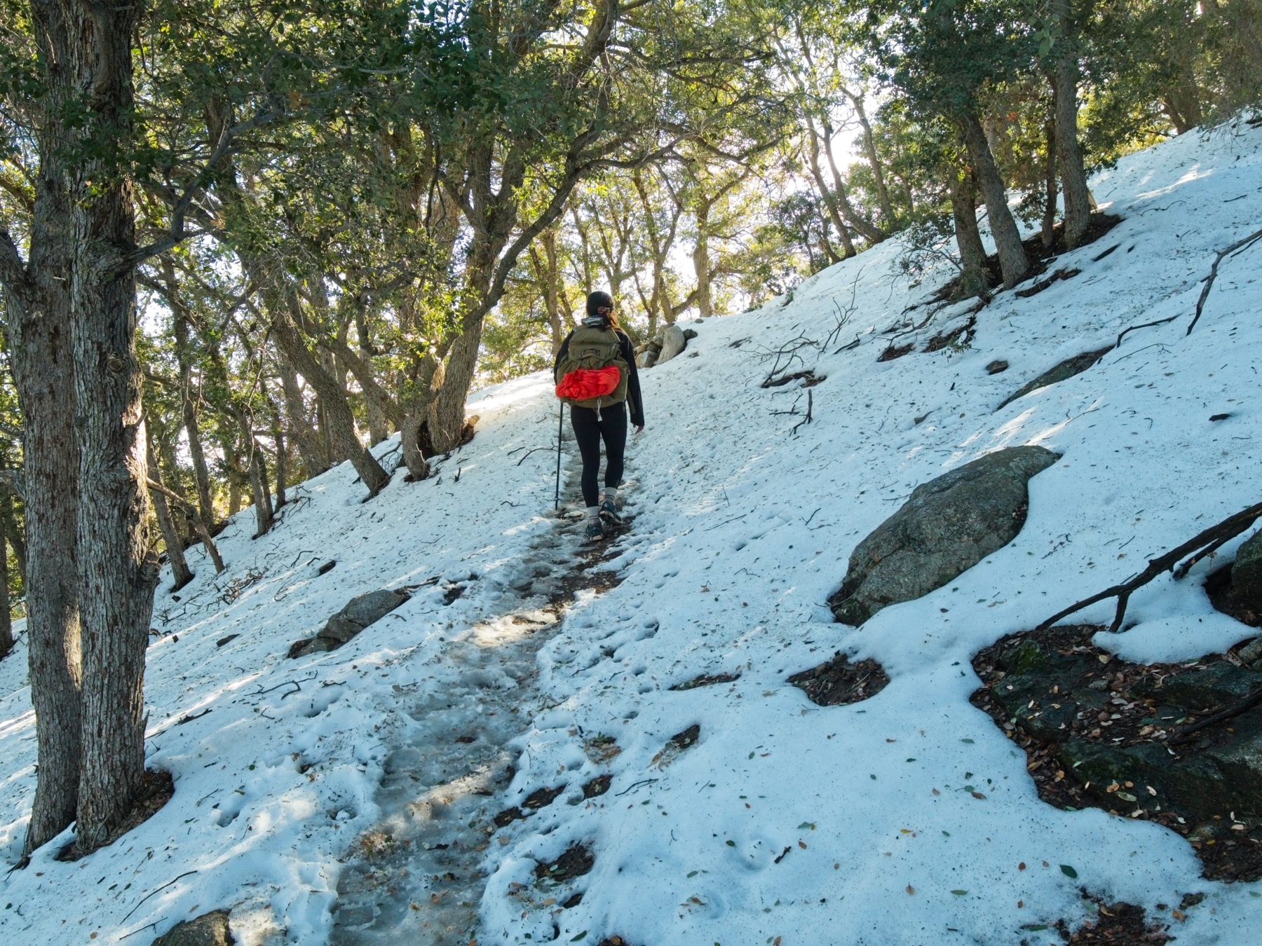
The San Gabriel Peak Trail begins aggressively, switching back up the steep slope that overlooks the Mount Wilson road. The trail wanders across shaded hillsides and through dense patches of manzanita on the north- and east-facing slopes of Mount Disappointment. When Kim and I did this hike in early January, the trail was completely covered in snow (and occasionally ice). Kim anticipated the slippery conditions and brought microspikes but I underestimated the snow and slid around in my trail runners (only two days before I hiked to Brown Mountain and had no trouble with the snow).
Although most of this trail is sheltered in the trees, there are a few spots where you catch a glimpse of the mountain range. The Bobcat fire (fall 2020) burned large swaths of land east of Mount Wilson and the burn scars are obvious from the trail.
The trail reaches joins a paved road just below the summit of Mount Disappointment. Continuing up the spiraling pavement will deliver you to the summit; if you’re heading for Mount Deception, it’s easiest to depart the trail at one of the earlier places where it passes near the road. To reach San Gabriel Peak, continue southeast across the saddle; the pavement soon ends and the San Gabriel Peak Trail intersects with the Upper Sam Merrill Trail. Follow the upper path to San Gabriel Peak. This north-facing slope was very slippery!
Upper Sam Merrill Trail
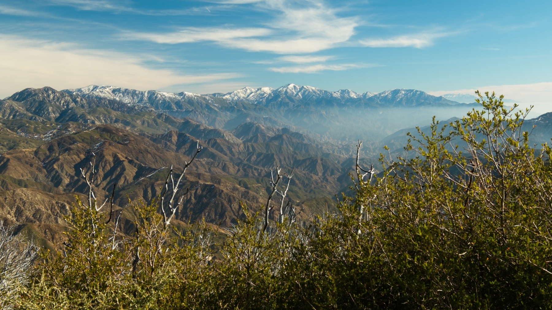
From the juncture with the San Gabriel Peak Trail, the Upper Sam Merrill Trail descends via a series of switchbacks. Old telegraph poles stills stand in a few places on this mountainside, hinting at the tourism industry that thrived in these mountains in the early 20th century. One of the switchbacks offers a fantastic view of Mount Wilson and Mount San Antonio (a.k.a. Baldy).
After descending a few hundred feet, the trail reaches a saddle and the Mount Lowe Road. If you follow this old path east, you’ll pass through an old tunnel and eventually reach the (paved) Mount Wilson Road. The westbound fork of the Mount Lowe Road contours around the northern face of Mount Lowe; connecting trails lead to the Tom Sloane Saddle.

The Upper Sam Merrill Trail parallels the Mount Lowe Road but stays level or ascends where the road descends. It’s an easy walk with beautiful views of Bear Canyon, Brown Mountain, and Mount Lukens.


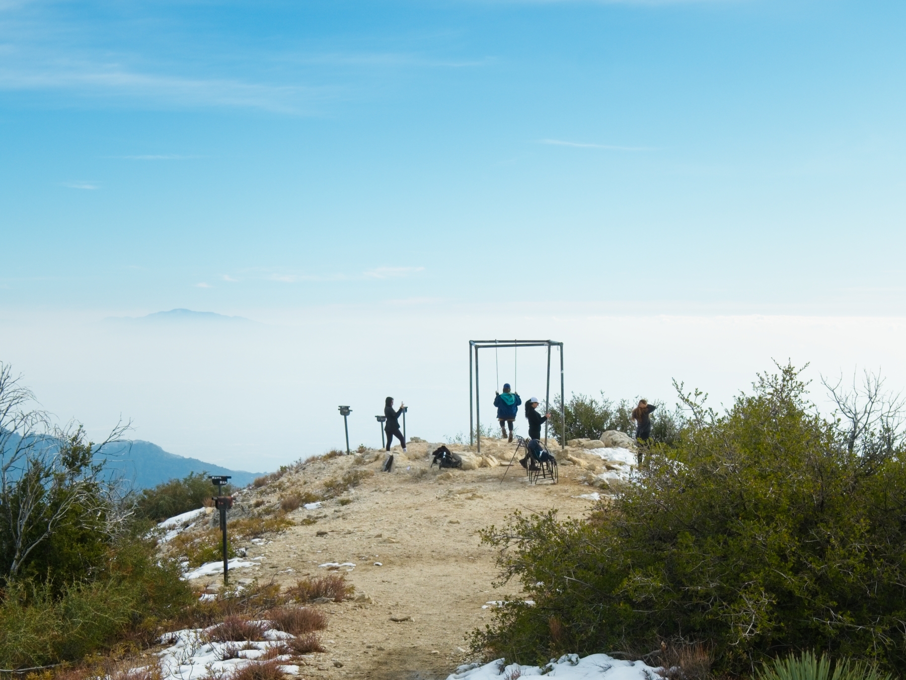
The Sam Merrill Trail soon connects with the trail circumnavigating Mount Lowe, and a quick jaunt leads to the summit. Someone has hung a swing from the hold metal frame up there, and a bench offers a comfortable spot to rest and admire the views of the city below. There are also a dozen or so scopes scattered around the summit that point to different peaks and landmarks in the surrounding mountains.
The path to Mount Markham is inconspicuous and departs from the Upper Sam Merrill Trail at the gravely saddle between Markham and Lowe. It’s a steep and rugged climb, but the summit is worth it. There are several flat spots where you can sit on a rock and stare into Eaton Canyon some 1500 feet below. Spanish explorers originally named the canyon “El Precipicio” for the sheer cliffs. I spent a good half an hour admiring the view.