This weekend I joined Craig and Kurt on a hike over Lamarck Col to Evolution Lake. Craig and I climbed the Hermit and Mount McGee; Kurt joined us for the Hermit but then went his own way to climb a few other peaks.
Trip Planning
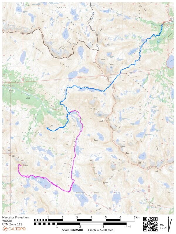
Specs: 37.6 mi | +/- 11,300 ft | 3 days, 2 nights
Difficulty: The cross country travel was mostly class 1 – 2 with some class 3 terrain on the scrambles up The Hermit and Mount McGee. The Hermit has a short (20 – 30 foot) class 5 summit block [ratings].
Location: Inyo National Forest and Kings Canyon National Park, California | Home of Eastern Mono/Monache and Northern Paiute peoples | View on Map
Route: Follow the Lamarck Lakes Trail to Upper Lamarck Lake and then divert onto the Lamarck Col Trail. This path leads up to the col and then splits into myriad use trails on the southwest side of the ridge. Luckily, you can’t really choose a “wrong” way down, just head for the string of lakes on Darwin Bench. Pass the lakes on their northern sides and follow the faint trail down to Darwin Canyon and then onward to the JMT / PCT. From here, hike to Evolution Lake. See Secor’s High Sierra book for detailed route descriptions to The Hermit and Mount McGee (or read the trip report below).
Permits & Regulations: As with all eastern Sierra trailheads, a permit is required for overnight trips. You’ll also need to store your food properly; I recommend a bear canister as trees are few and far between on this route. Overnight parking is free, but it’s a little bit of a walk to the trailhead. Remember to follow the Leave No Trace outdoor ethics!
Resources: I recommend the Sequoia and Kings Canyon National Geographic map for trips in this area. The Lamarck Lakes Trail USFS page is also a fantastic resource, and Secor’s High Sierra book provides details on the peaks and cross-country travel.
The Hermit
Saturday, 31 Aug 2024 | 12.9 mi | +5600 / -4100 ft | View on Map
Craig and I hit the trail this morning at 6:15, right at first light. Kurt, worried that he’ll be slower than we are, left over an hour ago; we’ll meet up with him at Lamarck Col, if not before. Almost immediately after leaving the trailhead we begin a steady uphill march to the Lamarck Lakes. My legs feel tired already, probably because I’ve been backpacking the past three weekends and training for a trail race in between. Luckily, it’s a beautiful morning and I’m able to distract myself from the tired muscles. I settle into a comfortable pace and trudge up the trail behind Craig.


We catch up with Kurt just below Lamarck Col. I’m meeting him for the first time, but he and Craig have hiked together several times. We struggle up the final thousand feet to Lamarck Col, which I completely forgot was at 12,900 feet and not 12,000 feet… No wonder it feels difficult! The ever-present snowfield below the pass is heavily sun-cupped, so walking up is almost as easy as climbing a steep flight of stairs. I reach the pass at 9:30 and take a break with Kurt and Craig for a few minutes.


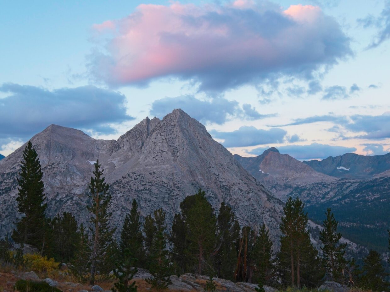
The views from Lamarck Col this morning are nothing short of phenomenal, particularly to the south. Mount Darwin and Mount Mendel tower above lakes that are dyed teal by the glacial till. The lake basin, called “Darwin Bench,” is barren and rocky, but beautiful in that glacial-alpine way. Scattered cotton ball clouds drift overhead, casting fuzzy shadows on the otherwise sunlit mountains. I’m just happy it isn’t snowing like last weekend.
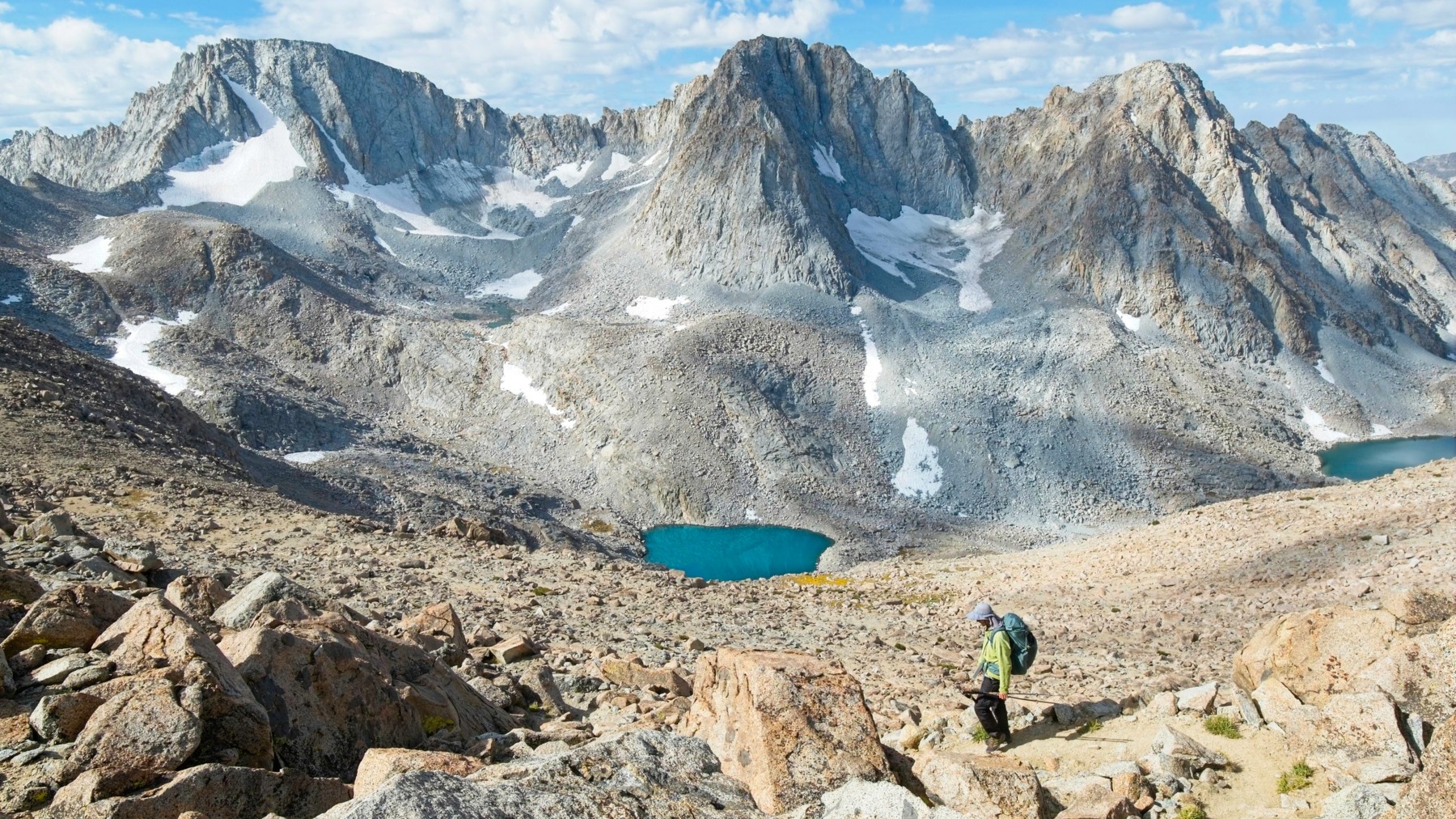
After resting, the three of us descend the southern side of the pass. For a few hundred feet, a clear trail winds through the boulders, but it soon splits into dozens of different use trails. I’ve crossed this pass once before, on a similar peak bagging trip to Mount Goddard, and I have a general recollection of a “good” way to go, but generally all lines go to the bottom of the canyon and converge to a common path.
I snap many, many pictures of the lakes on the way down, particularly once we reach some grass and other plant life. Last week’s cold snap has rushed the foliage into autumn a month early; many of them are bright gold or rusty red, colors you normally don’t see until October.


Craig, Kurt, and I pass several people during the hike down to Darwin Bench. It’s a popular spot for hikers adventurous enough to brave cross country travel and there are always at least a few people up here. The Darwin Bench and Darwin Canyon areas are much drier than I remember from my last trip (which was in early July, 2021). Several prominent creeks are dry and the lakes are a few feet lower than their capacity.
We loose the trail once or twice where it fades out or follows granite slabs, but we just keep walking down-canyon and pick it up again. The trickiest part of the route finding is in lower Darwin Canyon where the trail seems to veer left (SSE) toward Evolution Lake. We are able to find a way down through some cliff bands, but a far easier route stays right (SW) and very close to the outlet from the lowest lake.


We reach the John Muir Trail (JMT) / Pacific Crest Trail (PCT) at noon and hurry up the path to Evolution Lake. Craig and I set up our tents and toss in our camping gear. Kurt plans to camp higher up the valley near Wanda Lake, so his bag remains packed. He heads off toward the Hermit while Craig and I finish unpacking and scarf down some food.
The hike over to the Hermit requires a bit of route finding. Secor advises climbing the ridge south of the lake for a few hundred feet, but Craig and I balk at that suggestion and instead descend immediately to a tree-covered bench one or two hundred feet below. The bench (or a series of benches, really) winds through the granite cliffs, providing a relatively easy route to the large meadow that sits below and directly east of the Hermit.
From the meadow, Craig and I ascend a grassy chute and dry stream bed for 800 vertical feet. It’s steep and cardiovascularly difficult but technically easy. The chute ends in a small, boulder-filled cirque. Kurt has already deposited his heavy backpack next to a boulder, so Craig and I leave our trekking poles there and then hurry across the talus to join him. Secor describes several variations to reach the summit from here and I’m eager to follow the most direct option: a diagonal chute that leads up to a loose gully, which we will cross and then scramble up class 3 ledges to the top. It looks like a good line, so we make our way to the base of the chute.

 from the meadow")


Kurt leads the way up the chute, being very careful to avoid knocking rocks down on Craig and I. It’s not an easy task; the chute is full of loose rock. The climbing is otherwise straightforward and goes at class 3. When we reach the top of the chute we find ourselves looking down into the “loose gully.” Our first reaction is, “how much looser can it be?” Much looser, is the answer. Although we look around for a way to cross the gully and reach the class 3 ledges that Secor describes, we don’t see an obvious way to get out of the gully, so we scramble up it instead on treacherously insecure ground to the top.


From the top of the gully, we scramble through pine trees and over some class 3 rock. By 3:10 we’ve reached the summit block, an L-shaped tower that requires some serious rock climbing to summit. We’ve brought a rope, harnesses, and belay devices with the intention of tossing the rope over the top of the block and setting up a top-rope climb. Throwing the rope all the way over the rock is difficult (it’s 20 – 30 feet tall), so we tackle it in two “pitches.” I belay Craig up 10 – 15 feet to the foot of the “L”. He then pulls the rope up and is able to toss it over the next 10-foot section; I put him back on belay for the final bit of climbing. There aren’t many hand or foot holds on the rock face, and Craig only has trail runners, so it’s tough! After he makes a few attempts, I put my full body weight onto the rope and he’s able to pull up on the rope to reach the top.
Kurt climbs next, following the same route as Craig, but now on a single belay since the rope is over the top of the rock. Kurt is new to rock climbing and also struggles with the blank top half of the climb so we resort to the same trick with me acting as a counterweight to the climber. After I lower Kurt back down from the top, Craig puts me on belay. I really enjoy climbing the 5.7 off-width crack (it’s ~8 inches wide), even if it is only 20 feet tall. A light drizzle begins to fall as Craig lowers me, so we hurry to sign the register and pack up our gear.


On the way down the mountain we’re eager to avoid the loose gully so we stick to the east face and descend the class 3 ledges. When we reach the cliffs above the gully, we find a descending ramp hidden by trees that allows us to drop in and cross the gully back to the diagonal chute. Scrambling down the chute is loose enough and we’re all grateful to reach the safety of the boulder-strewn cirque where we stashed our gear.
Craig and I part ways with Kurt at the top of the grassy chute. Kurt plans to hike cross country over to Wanda Lake and then climb Mount Goddard and a few nearby peaks tomorrow. We wish him good luck and then reverse our approach route through the meadow and forested benches to Evolution Lake.


Craig and I reach Evolution Lake around 6:20 and wash off in the lake before settling down for dinner. Unsurprisingly, there are lots of other backpackers here for the night; this basin has a well-deserved reputation as a beautiful camping spot. We get a kick out of a group of young guys loudly proclaiming their relief at reaching the lake; their voices carry and we can hear their “holy fucks” and “thank gods” for a solid 10 minutes as they hike past.


Once the sun has dipped below the horizon, I crawl into my sleeping bag and read until it’s dark. It’s been a long day and my body is thoroughly worn out, so I fall asleep very quickly.
Mount McGee
Sunday, 1 Sep 2024 | 15.2 mi | +/- 3400 ft | View on Map
My alarm goes off at 6 AM this morning, a comfortably “late” wake-up time for mountain-climbing trips like this one. Craig and I are planning to climb Mount McGee today. It’s only 7 miles away, so we’re not in a huge hurry. I might climb Mount Huxley on the way back if I have the time and energy, but that’s a stretch goal.
We leave camp at 7:00 and enjoy an easy stroll up the JMT / PCT to Wanda Lake. There’s a distinct smell of smoke in the air but it doesn’t look too hazy; I’m not sure where the fire is. From the outlet of Wanda, we hike cross country to Davis Lake Pass, a wide saddle a few hundred feet above Wanda Lake. We wind our way through the boulders on the pass and Craig locates a perfect ramp that leads all the way down into the Davis Lake basin below.


Davis Lake stretches out for what looks like miles in front of us and we have to decide which side of the lake to walk on. Many of the GPS tracks I’ve seen pass the lake on the south, but Craig and I like the look of the north shore better. It’s a much more direct line to Mount McGee (which is on the north side of the lake) and we can’t see any cliffs or tedious obstacles that would make the south shore a better option. Our assessment turns out correct and we’re able to walk around the north side of Davis Lake with ease. One or two short stretches of talus provide a little technical difficulty, but it doesn’t seem worthwhile to add half a mile of distance just to avoid a little talus.
")


Although the walking is easy, hiking past Davis Lake takes a full hour, a testament to its size. At the foot of Mount Mcgee, we leave the lake and climb up a few hundred feet to avoid some cliffs, but I think it might be possible to remain next to the lake shore for most of the hike. Regardless, we make our way over a few short ridges and grassy meadows to the base of the “southwest chute.” It’s not an inspiring sight: an apron of sand and loose scree leads to the rubble-filled chute.
The climbing is as bad as it looks. Craig and I slip and slide on the scree, sliding backwards a little with each step. We try to find lines on more solid, exposed rock, but solid slabs are infrequent and covered with lots of little rock fragments. Once we reach the chute the rock quality improves a bit – it’s less loose – but tenuous and slippery. Craig and I complain about it all the way up.


Mount McGee’s summit ridge provides some stable rock at last. It’s all sharp shale, but with less loose sand and dirt to make things slippery. We arrive on the summit at about 12:30 and take a very long break, avoiding the descent for as long as possible. I enjoy the view from the summit, particularly looking down into the McGee Lakes basin. As far as I know there isn’t a trail to the lakes, but they look like a fantastic spot to camp. There are a few peaks shrouded in smoky haze to the north that Craig and I struggle to identify. We finally realize they’re Gemini and Seven Gables, the two mountains I climbed last weekend! I didn’t realize they’d be visible from here; it’s cool to know that I was there just a few days ago.


After avoiding the descent as long as we can, Craig and I begin the journey back. It’s truly a disgusting chute. The stability of every footstep is suspect and we send rocks crashing down more than once. I’m incredibly relieved when we reach the bottom of the scree. I can’t believe Doug Mantle has climbed this mountain eight times. Why, Doug, why?


The hike back to Davis Lake Pass goes a little more quickly than the hike in since we’re no longer guessing at the route. We find that perfect ramp again and stroll down to Wanda Lake where we rejoin the PCT. I’m no longer interested in climbing Mount Huxley. I’m tired, have a headache from the smoke and altitude, and the idea of scrambling up talus or scree is completely unappealing. Craig is also tired and puts in some headphones for the four-mile walk back to camp. I settle into my own (slower) pace and try to enjoy the evening light and the scenery.


Craig and I reach camp at the same time, 5:45, and repeat last night’s rinse in the lake. We eat dinner and, later in the evening, stroll over to the outlet of the lake to see the sun set over Evolution Valley. I’m in bed again by 8 PM and asleep soon thereafter.
An Early Out
Monday, 2 Sep 2024 | 9.5 mi | +2300 / -3700 ft | View on Map

Craig and I are up early this morning and hit the trail by 6 AM so that we can get back to the trailhead and home to LA at a reasonable time (it’s Memorial Day; there will be traffic). A cold wind blows down Darwin Canyon and Darwin Bench, and there’s no sunlight yet, it’s still hidden below the Sierra Crest. I hike with a few layers on and am still cold.


We struggle up the sandy slope above Darwin Bench and top out at the wrong part of the ridge. It’s really difficult to tell which gap is the pass, but it’s pretty easy to walk across the ridge the find the correct spot. There are several other groups at the pass or descending from it, all on their way out of the mountains with us. Even though we’re in the sun now, I’m still cold; I don’t really warm up until we reach the Lamarck Lakes.


As is often the case during the hike back to the car, the last mile stretches on and on. I don’t remember there being so many switchbacks on the way up! I enjoy seeing a few splashes of gold in the aspens, another early autumn display prompted by last weekends’ freeze. We’re back at the trailhead by 11:20 and eagerly drive into town for a burger. What a great trip to end the summer season!