Back in 2019, Diane, Daniel, Josh, and I were hoping to visit the Maroon Bells but it was too snowy (we ended up visiting the Lost Creek Wilderness instead). This year conditions were looking good, however, so we reprised our plans to hike the Four Pass Loop. Although this loop doesn’t offer much in terms of solitude, it’s incredibly beautiful and worth visiting!
Trip Planning
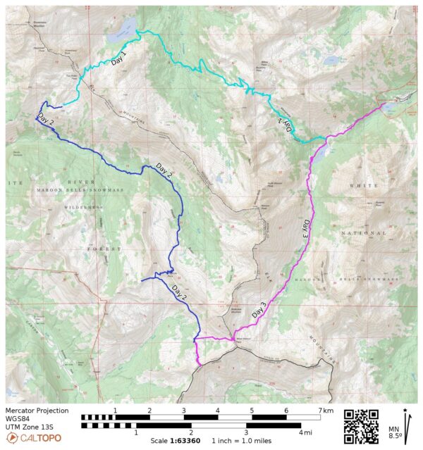
Specs: 27.4 mi | +/- 8100 ft | 3 days, 3 nights
Difficulty: Class 1 [ratings]
Location: White River National Forest | Home of Ute people | View on Map
Route: Begin at Maroon Lake and hike up to Crater Lake. From here you have the choice to proceed around the loop clockwise or counter-clockwise; we chose CCW but I don’t really see any reason that one direction would be better or easier that the other.
Permits & Regulations: Permits are required (and very expensive) for overnight trips in this area. For most of the four pass loop, permits are allocated per “zone,” but Crater Lake campsites are reserved on a per-campsite basis. Additionally, food must be stored in bear-proof containers. Visit the recreation.gov page and the forest service page for many more details.
Resources: The recreation.gov and forest service pages linked above provide most of the information you’ll need to know. An additional logistical consideration is parking at the trailhead; cars are only permitted up and down the road early in the morning and in the evening; during the day access is limited to a shuttle bus. See the Aspen Snowmass website for details.
Night Hike to Crater Lake
Thursday, 15 Aug, 2024 | 1.8 mi | +600 ft | View on Map
Josh, Daniel, and I meet up in the Denver airport around midday. Diane is already in town and is picking up the rental car, so we hop on the shuttle bus and meet her at the lot. By the time we’ve grabbed lunch and made it to the Rockies (I-70 through Denver is closed today…) it’s well into the afternoon. We follow the mountain route past Copper Mountain, through Leadville, and arrive in Aspen in the early evening. After a quick dinner, we drive up to the trailhead.
It’s completely dark when we begin the hike. We don’t have far to go, however, and an easy night hike feels nice after sitting on a plane and in a car all day. We reach Crater Lake in about an hour and walk over to the campsite we’ve reserved only to find it occupied. The next door campsite is also full, so it seems they’re just squatting. They’ve left quite a mess too – food sitting out, dirty dishes in the open air, even some food wrappers scattered around.
The campers wake up as we look around for other spots to camp. They’re annoyed at first but at least have the grace to offer to move when we tell them we reserved this site. They tell us they’ll be leaving at 3 AM to go climb some technical peaks. I’m not sure why they bothered to hike in 2 miles and camp illegally if they were planning to get an alpine start. Why not just sleep at the trailhead and then hike in without backpacking gear?
There’s not nearly enough room to pitch tents in the area near the campsite; the trees are dense and the ground uneven. But there are a few people-sized flat areas where we could sleep. The weather forecast for tonight is benign, so we decide we’ll cowboy camp; it’s not ideal, but it’s workable.
Buckskin and Trail Rider Passes
Friday, 16 Aug, 2024 | 9.3 mi | +4000 / -2500 ft | View on Map
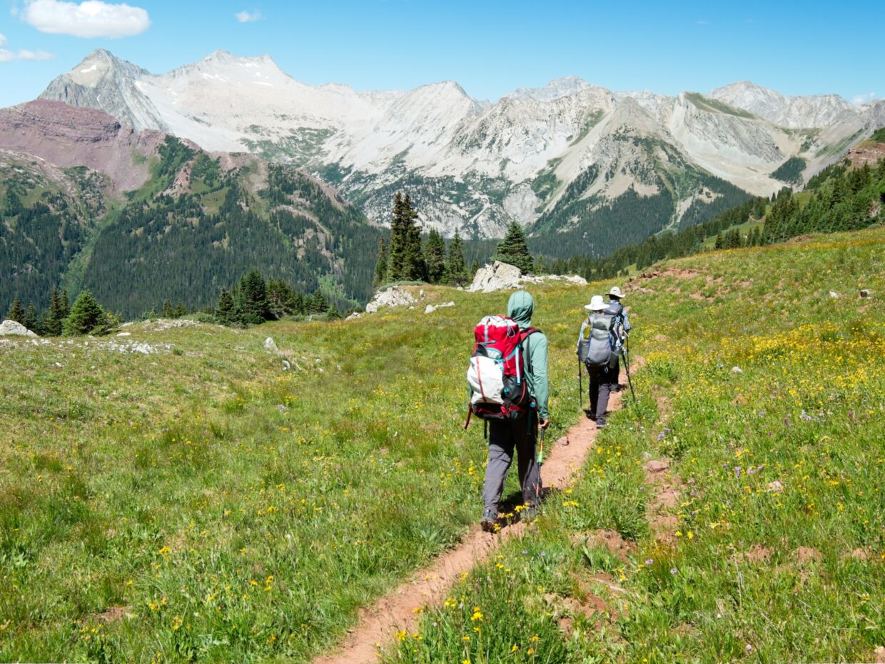
We sleep in a little since we arrived so late, but we’re on the trail by 8 AM. Although we’re only hiking about 10 miles today, we have quite a bit of elevation gain to accomplish, so an early start gives us plenty of time to enjoy the walk. We head up the trail toward Buckskin Pass from Crater Lake, hiking through some dense thickets of aspens and then, higher up, shady pine glades.
We stop at a creek partway up the hill and are treated to the coolest wildlife encounter I’ve ever had. A fox trots around the corner of the trail with a marmot in its mouth, stopping just feet away from us. I think it’s as surprised to see us as we are to see it! For about five seconds, the fox just stands there, staring at us. It starts walking back up the trail but then changes its mind once or twice before finally committing to plunging downhill through the thick plants.


As we climb higher, the trees and willows give way to rocky, wildflower-filled meadows. There are a spectacular number of flowers in every possible color and we pause many times to snap photos of them. We see dozens of other hikers and backpackers too, some finishing the loop, others starting, and even a few runners that will complete the entire loop today!
The hike up to Buckskin Pass feels difficult, both because my pack is heavier than usual with several days of food and because it’s a high pass – 12460 feet! I’m happy to sit down up top and take a break with Josh while we wait for Diane and Daniel to complete the climb. A stiff breeze gusts over the pass, so I take a few steps down the leeward side of the slope and find a sheltered spot to sit. Daniel and Diane arrive a few minutes later, and we all appreciate the views up top before starting down the west side of the ridge.


The next three miles are all downhill and reverse the ecological evolution of the uphill hike. We start out strolling through beautiful meadows and then drop steadily into more and more trees. We stop for lunch in a shady stand of pines beside Snowmass Creek. It’s a beautiful spot, but the air is muggy and uncomfortably warm. I didn’t expect humidity out here. The mountains are spectacularly green, so maybe it’s just a wet year.
After eating lunch we hike another 1.5 miles to Snowmass Lake and spend a few minutes wading in the water and cooling down. The views are great too! Snowmass Peak towers above the west end of the lake, and the shore is lined with pine trees and plenty of campsites. As nice as it would be to camp here, our permit requires that we cross Trail Rider Pass into the “North Fork Zone” so we still have a few miles and several thousand feet of elevation gain to go.


We rejoin the trail and begin a slow uphill march to Trail Rider Pass. As with the terrain this morning, it’s a gradual transition from trees to rocky meadows and wildflowers. A concerned hiker warns us about a “tricky” talus field ahead, which gets my imagination going, but it turns out to be trivial; there’s even a path through most of it.


As we slowly gain altitude we’re treated to increasingly sweeping views of Snowmass Lake and the colorful mountains to the east. The wildflowers are also gorgeous! There aren’t a lot of places with this kind of amazing flowers; the Tetons, Winds, and Glacier NP are the only others I’ve visited with equally impressive displays.


We reach Trail Rider pass just after 4 PM and take a long break up top. There’s a curious rock formation that feels like compressed sand – it’s incredibly soft and crumbles easily into tiny grains. It makes for a nice, soft seat.
After resting, we hike down the south side of the pass. We’re aiming for a small lake in the valley below; a few nearby pine trees promise campsites. It only takes a half hour to reach the lake and we find plenty of space to camp in the trees, as expected. Josh and I both jump into the lake to cool off, which feels amazing! There don’t seem to be many mosquitoes out either, so I’m able to lounge in the late afternoon sun and dry off without being eaten alive.


Later in the evening, we all walk over to a nearby hillside for dinner. Diane brought along a couple of space-themed IPAs from some aerospace engineering friends and we drink them with dinner tonight. It’s a fun, laughter-filled evening; even half an IPA each is enough to get us tipsy up here at 11.7k feet. Several groups of backpackers arrive in the valley while we’re eating, but we’re spread out far enough that it doesn’t feel too crowded. After dinner we walk back to our campsite, watch the alpenglow drift over the mountains, and then go to bed once darkness falls.

Frigid Air Pass
Saturday, 17 Aug, 2024 | 9.0 mi | +/-2500 ft | View on Map


I wake up feeling much more rested this morning than I did yesterday. I watch pink cotton-candy clouds drift across the sky from the comfort of my sleeping bag and eventually brave the chilly morning air to go find a bathroom spot. We’re all packed up and on our way at 8:00, this time starting with a steep descent to the North Fork of the Crystal River. The wildflowers are once again the star of the show!
 perfectly!")


As we near the bottom of the canyon we pass through more and more trees – both aspens and pines. The air is certainly more humid down here, but thankfully the trail is also fairly flat. We pass several dozen more hikers, trail runners, and backpackers this morning, which makes this probably the most crowded trail I’ve ever backpacked on. Even the John Muir Trail had fewer people.


Partway up the canyon the trail crosses the North Fork. There’s not a bridge or even rocks to hop on, so we wade through. The water is icy cold and my feet and legs are burning when I get to the other side. A little further up the canyon we reach a waterfall that is perfectly framed between pine trees and red cliffs. The trail climbs the cliffs via a series of switchbacks, topping out right above the falls. From there, the terrain flattens out and I enjoy a nice stroll up the canyon.


We stop for lunch at 12:30 on a rocky outcrop surrounded by – you guessed it – spectacular wildflowers. They never really get old. The heat and humidity feel worse today, so we rest for a bit before completing the climb to Frigid Air Pass. As with the lower canyon, there are dozens of people on the trail and on the pass.


Our permit for tonight requires us to camp in the “East Fork Zone,” which is now stretched out below us from Frigid Air Pass. There aren’t many obvious options, at least not without descending several thousand feet. Our plan is to hike the traversing trail to just below West Maroon Pass and (hopefully) find a camp-able spot in the trees. However, before going in search of a campsite, there’s a second nearby pass just to the west that looks cool, so we head over there for a look. We drop packs just off trail and Josh and I jog over – I’m soon dizzy from the lack of oxygen and have to stop to walk, giving me a new appreciation for all these trail runners. Diane and Daniel aren’t far behind us and we all admire the view to the north of Snowmass Mountain and the little plateau where we camped.


After a few minutes at the side pass, we return to our packs and hike toward West Maroon Pass. Clouds are gathering overhead, potentially bringing rain, so we hurry along. The forecast from a few days ago predicted a slight chance of rain this afternoon and a much higher chance tomorrow afternoon. It’s looking like the slight chance will be a 100% chance.
At a trail junction at 11.7k feet we find a hand-carved sign point southwest to “campsites.” A faint use trail heads off toward some pines on a ridge, so we follow it out and find several excellent spots nestled into the trees. We scout up and down the ridge before settling on a site and then get to work putting up the tents. We finish just as the rain begins. I take cover in my tent for a little while, but eventually pop back out. The pine trees shelter us from the bulk of the wind and blowing rain, so I’m comfortable enough sitting outside with a jacket on.


Thunderstorms drift through in waves, each about 30 – 60 minutes apart. We cook and eat dinner in the break between two storms and then watch the rain and lightning sweep across Galena Mountain in the distance. The storms peter out just before sunset. As clouds break up, the sun streams through and creates a double rainbow over West Maroon Pass. The sunset itself is pretty too, with a nice mixture of deep blues and light orange in the clouds.


West Maroon Pass
Sunday, 18 Aug, 2024 | 7.3 mi | +1000 / -3100 ft | View on Map
Although the thunderstorms stop after sunset, it rains a bit more in the night. Thankfully, dawn brings mostly clear skies and plenty of sunshine. We don’t have many miles to hike today, so we decide to do a short cross-country hike from our campsite to an interesting looking pass adorned with several rocky spires. It’s not a long walk – just over half a mile – and only 350 feet above our campsite elevation. We pass a small lake on the way and I’m excited to see moose prints in the mud! We don’t see any actual moose, unfortunately, but it’s cool to know they’re up here.


The views from the pass are awesome, both down into Rustler Gulch and across the East Fork canyon. There’s a little cell service as well, so Josh checks the weather forecast to get an updated prediction of this afternoon’s rain. The forecast from before the trip is still holding: there’s a 40 – 60% chance of rain at 4 PM this afternoon. But there’s now an increased chance of rain all through the night and into the morning. Our original plan for today was to hike to Crater Lake and camp there for one more night before driving back to Denver. But with rain forecast through the night and into the morning, we decide it will be easier and more comfortable to hike all the way out tonight and stay in a hotel.
After enjoying the pass for a few more minutes we hike back down to our campsite, pack up, and walk over to the main trail. We join the caravan of people hiking uphill and settle into our own paces. It’s humid again and there’s not much of a breeze, so I’m dripping sweat as I trudge up the trail to the 12.5k-foot pass. On top the wind gusts through the rocks and I pull on my hardshell to stay warm while I wait for Daniel and Diane.


There are a ton of people on the pass, some just passing through, others lounging around, and one group even making coffee. Josh, Diane, Daniel, and I take a short break there and then start down the trail, leap-frogging other hikers and backpackers. This is by far the most crowded trail we’ve hiked yet, probably because we’re so close to the trailhead and it’s a weekend morning.


As the morning wears on we descend out of the wildflower-filled meadows and into thickets of willows. For now, at least, the clouds are fluffy and fleeting, so rain isn’t an immediate concern. We pass through Crater Lake and then head down the trail that we ascended in the dark on Thursday night. It’s nice to see the forest this time around, particularly all the beautiful aspen trees.


By the time we reach Maroon Lake, the clouds are beginning to coalesce and darken. It’s been warm and muggy all day and I’ve been looking forward to jumping in Maroon Lake, but it’s completely cordoned off by rope and a ranger informs me that swimming isn’t allowed (per White River-2022-03 forest order, set to expire Nov 2027). So we walk back to the car without a refreshing swim. There are at least bathrooms with running water at the trailhead, so we can wash off some of the sweat and dirt and change into cleaner clothes. We repack the cars with perfect timing; the rain begins practically as soon as we drive away.