After spending several days doing day hikes around Glacier National Park, my dad, Steve, and I embark on an 8-day, 7-night backpacking trip. Beginning at Logan Pass and ending at the Lake McDonald Lodge, this loop hits many of the highlights in the park! To avoid an über-long post, I’ve split the adventure into two articles; this one details the second half of the trip.
Trip Planning
See Part I for details about travel to Glacier National Park, permits, and other regulations.
Ptarmigan Trail
6 Aug | 14.6 mi | +2900 / -3100 ft | View on Map
It’s another chilly morning in Glacier National Park, and a very peaceful one at that. Steve and I pack up camp and cook a hot breakfast to ward off the cold and then sit beside Helen Lake and scan the shoreline for animals. In contrast to last night, when we saw zero animals, there are several moose grazing in the willows and a few deer wandering around as well! We wait for Henry and Eli to leave and give them a few minutes’ head start so that they can be the first people on the trail between Helen and Elizabeth Lakes and perhaps see some wildlife, like we did with the grizzly bear family last night.

About an hour later we catch up with the two Bostonians. Although they haven’t spotted any bears in the woods, they’ve seen a few more moose and some ducks. Steve and I spot yet another moose in a large clearing a little further down the trail and enjoy listening to the sounds of the loons. When we reach the pebble beach beside Elizabeth Lake, Henry and Eli spot a grizzly bear lumbering along the opposite shore. We stand and watch him for a few minutes but ultimately continue down the trail toward the foot of Elizabeth Lake.


It’s a beautiful morning for hiking, much like most of the other mornings we’ve experienced here. It’s sunny, there’s a light breeze, and the air is cool. I particularly enjoy strolling along the pebble beaches and through the golden grass that covers the hills beside the lake.
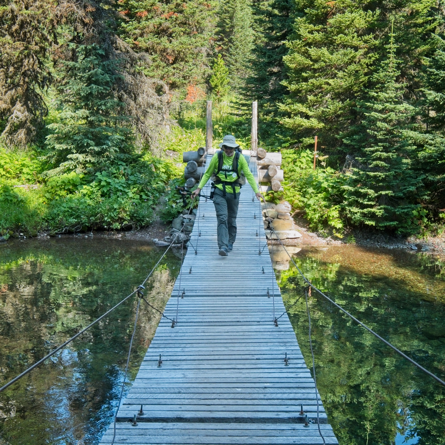
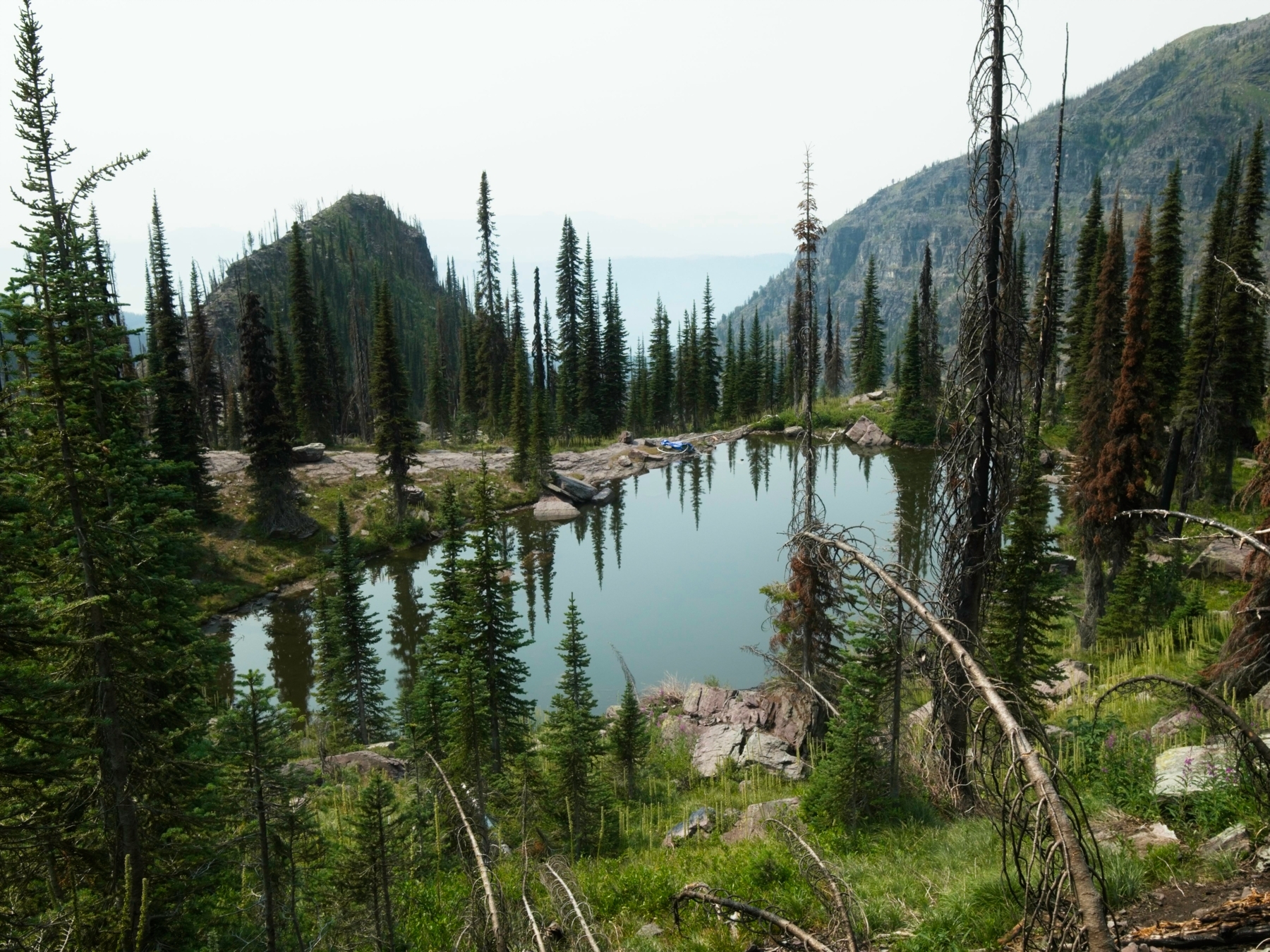
After a few hours of walking, we reach the foot of Elizabeth Lake and begin hiking along the Ptarmigan Trail. Just a couple feet past the campground we reach a bouncy suspension bridge that spans the outlet creek flowing out of Elizabeth Lake. Like most suspension bridges you find in the backcountry, the maximum capacity of this bridge is one person, so we cross one at a time.
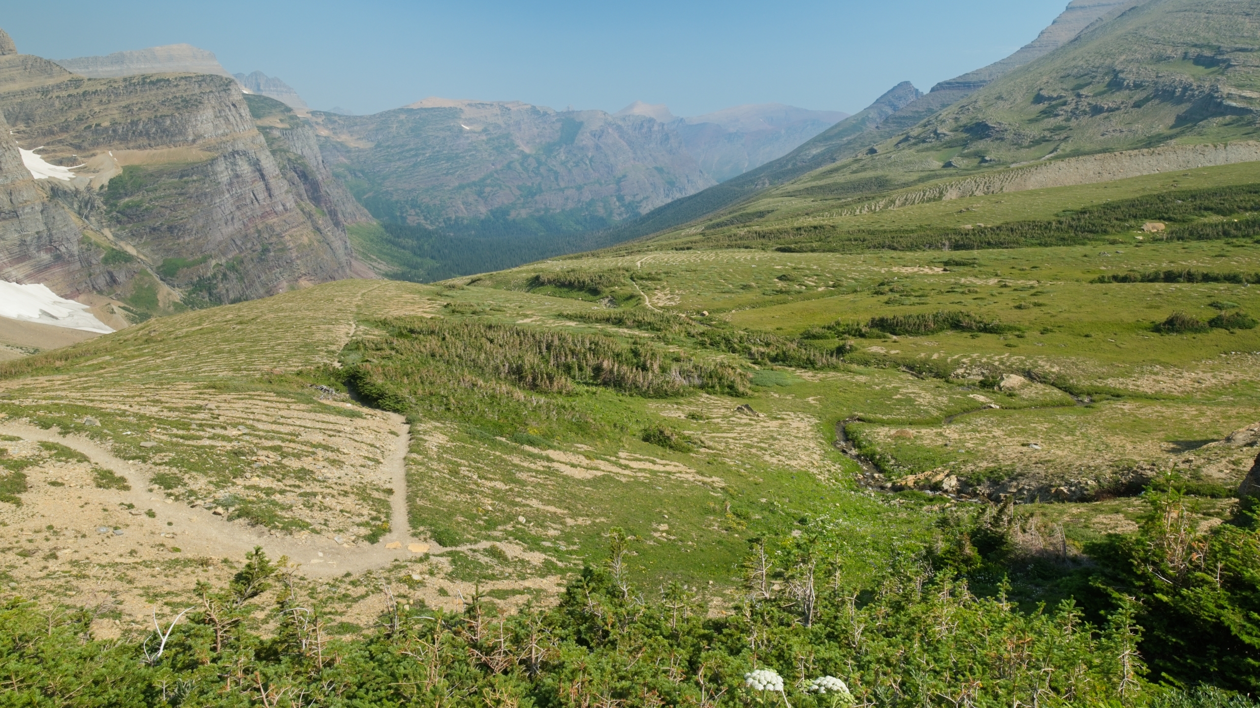
On the opposite side of the bridge, Steve and I begin a steady climb that will continue all the way to the Ptarmigan Tunnel. Thankfully, the trail gains altitude slowly so the climb isn’t too strenuous. After hiking for a bit, we climb out of the dense forest and are treated to panoramic views of Elizabeth Lake as well as glimpses of the now-distant Helen Lake.


For a while, the trail levels out and contours along the mountainside above Elizabeth Lake, weaving through stands of pine trees and stretches of open meadows. We pass a small waterfall and cross several creeks that are on their way to the lakes below. The easy walk ends as we round a corner into a large cirque lined with loose, red shale. Here, the path steepens and it climbs toward the Ptarmigan Tunnel, a small hole in the cliff on the far side of the cirque. There isn’t much life on these rocky slopes, but a few small, white flowers are thriving and waving in the wind.


As we wind around the valley, the slopes steepen even further until they’re vertical cliffs. The trail isn’t at all precarious, though; a stone wall lines the trail on the downhill side and the path itself must be eight feet wide. Besides the awesome, sweeping views from the trail, the cliffs themselves are interesting as well, with bright red and white striations.


Near the tunnel, we meet a family from South Carolina that we camped with several days ago at the Fifty Mountain campsite. They’re eating lunch and enjoying the views of the lakes and mountains. A brave chipmunk scampers around their feet, hoping to snag some crumbs. We exchange a few pleasantries and then Steve and I walk through a pair of imposing doors and into the tunnel. The air inside is damp and cool, like a cave. However, unlike a natural cave, the walls are rough and irregular, evidence of the jackhammers and dynamite that was used to excavate the tunnel.


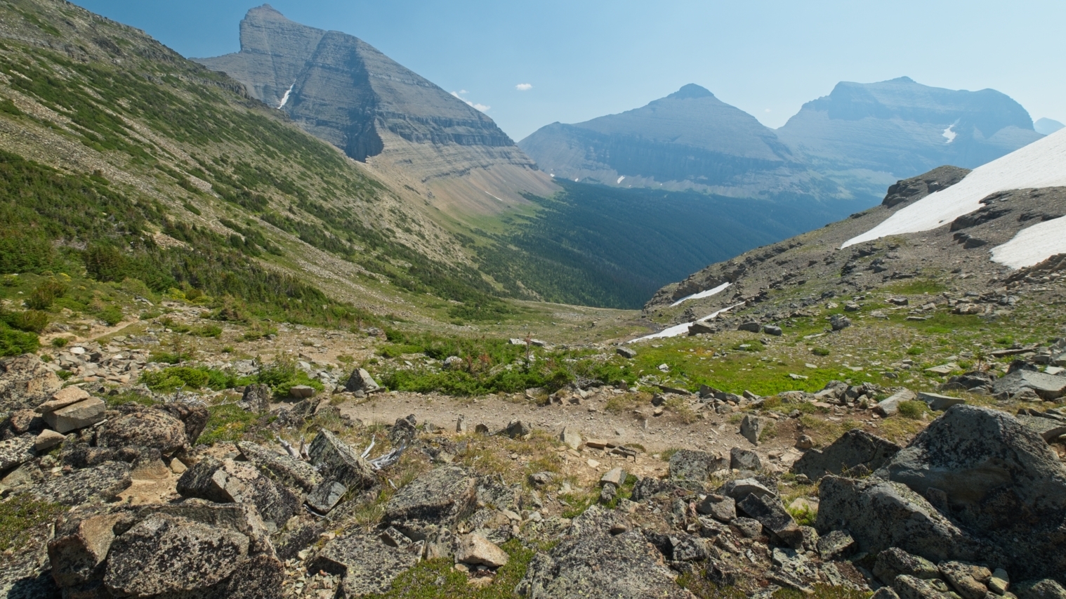
We emerge from the tunnel into bright, warm sunshine. Ptarmigan Lake glistens in the valley below and a steady stream of day hikers are moving along the trail toward the tunnel. We decide to have our lunch here in the warm sun before beginning the long descent to Many Glacier. An entire family of aggressive chipmunks gathers around us as we pull our food out of out backpacks and we spend half of our lunch break throwing pebbles at them to scare them away.
After lunch we resume hiking. The downhill grade requires less effort than the uphill climb we did this morning, but it sure it tough on my knees and feet! We pass many miserable-looking day hikers struggling up the trail toward the tunnel, dripping sweat and breathing heavily. One or two of them glare at me as I pass them with a cheerful, “hello!”
Steve and I refill our water bottles at the lake and then continue down the trail. The steep slope and hot, glaring sun make the walk a bit uncomfortable but we keep pushing, motivated by the thought of ice cream from the camp store in a few miles. It’s a long, hot walk, but we eventually reach the trailhead parking lot and the camp store. Before getting ice cream we walk over to the campground and locate the “backpacker area”, a small plot of tent pads in a sea of RVs. Once we’ve set up the tent and stashed our food in a nearby bear box, we walk back to the camp store and enjoy bowls of delicious huckleberry ice cream.
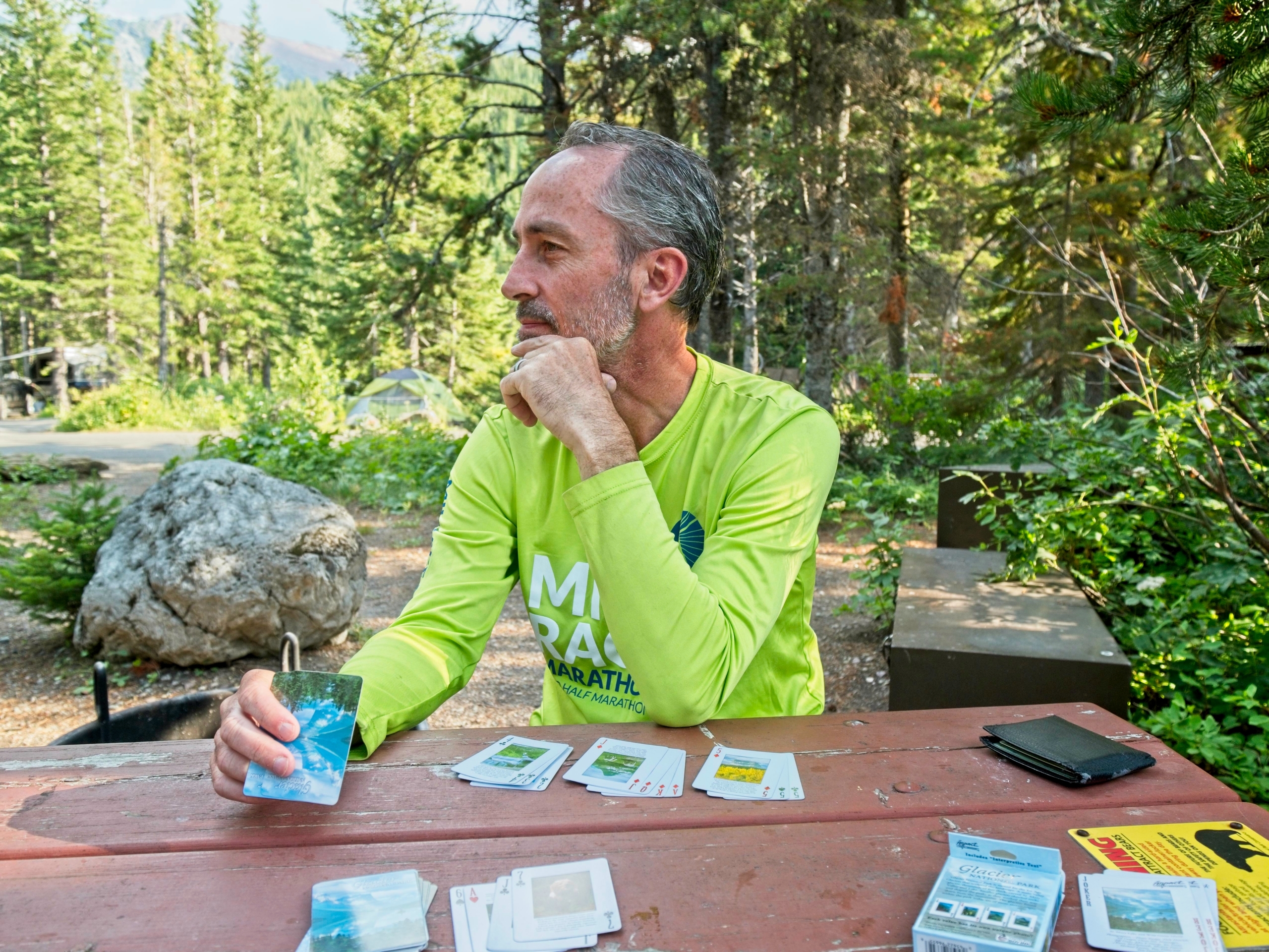
After the cold treat, we buy a bar of soap and shower tokens and head over to the camp showers. In true backpacker fashion, we wash ourselves and our clothes before the eight-minute timer ends. As neither of us has a towel, we sit out in the sun until our clothes are dry. Back at the campsite, we meet our neighbors and play cards for a while. Later in the evening we enjoy a hot meal at ‘Nell’s and attend a ranger program presented by a local Blackfoot Native American. Overall, it’s a nice, relaxing evening!
Piegan Pass Trail
7 Aug | 15.0 mi | + 3100 / -3400 ft | View on Map
While I appreciate the access to flushing toilets, running water, and ice cream, I don’t much enjoy camping at Many Glacier. The sound of generators and noisy neighbors make it difficult to sleep and generally distract from the sense of being in the outdoors. The morning is nice and quiet, though. Steve and I wake up at our usual time (somewhere around 6 or 6:30), and make quick work of tearing down camp. Several of the other backpackers camped nearby are also up and about, but we don’t see any of our RV neighbors. After eating breakfast, we walk out of camp and back into the woods.
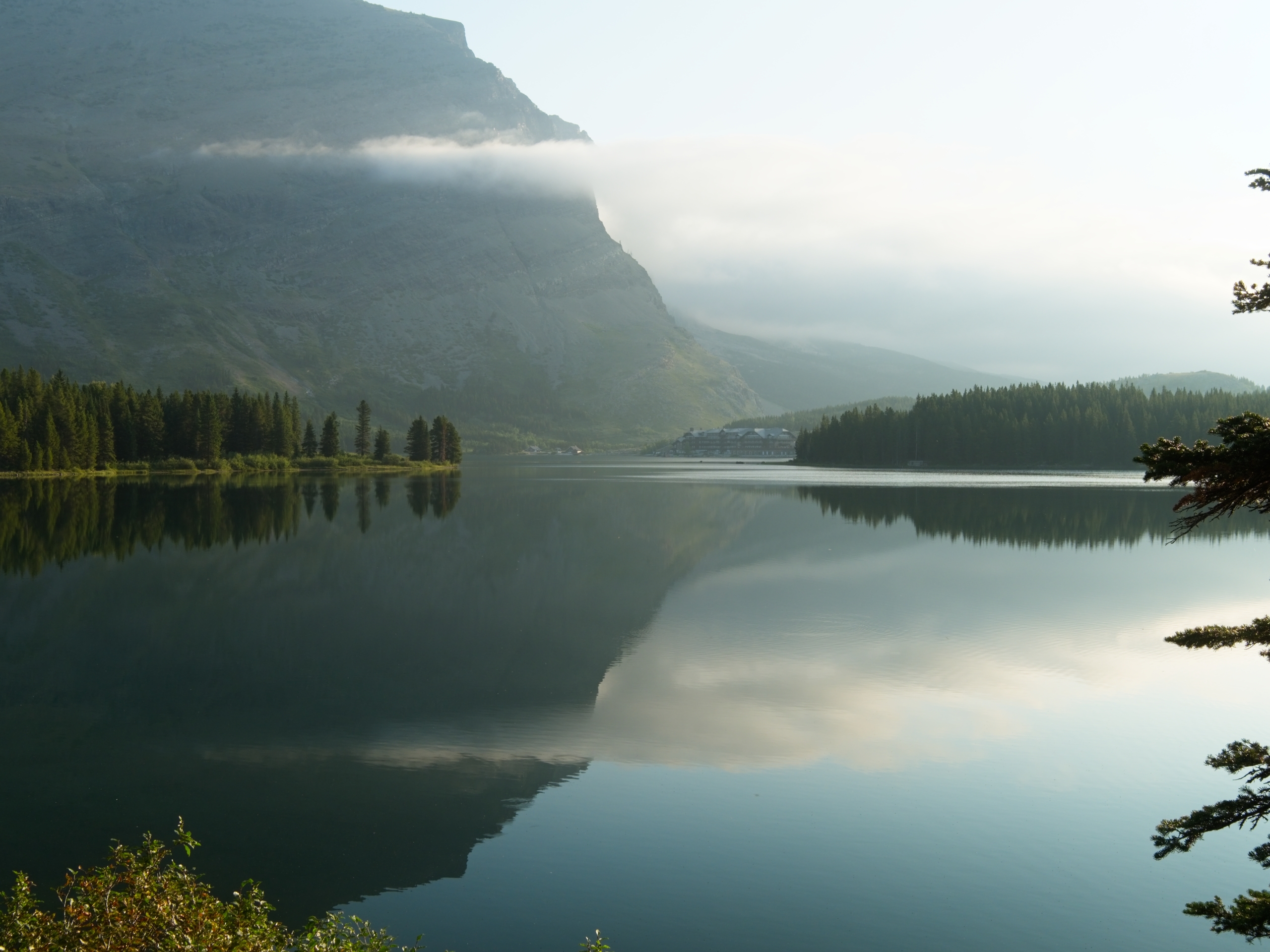
We follow a trail that winds around the western side of Swiftcurrent Lake, which is smooth as glass this morning. A few low-hanging clouds obscure the mountains that tower over this valley, adding a sense of intrigue to the otherwise calm morning. At the far end of Swiftcurrent Lake we cross a bridge and walk along the Stump Lake outlet. A bull moose grazing in the shallow water eyes us as we walk by. A little further down the trail we reach a warning sign alerting us to a trail closure ahead. We push on, hoping that the trail closure occurs after we reach the junction to the Piegan Pass Trail. Sure enough, right at the junction another blaze-orange sign announces that the trail is closed “all miles ahead” because of bear danger. We happily turn onto our new route and hike up and away from the lake (and, presumably, the bears).


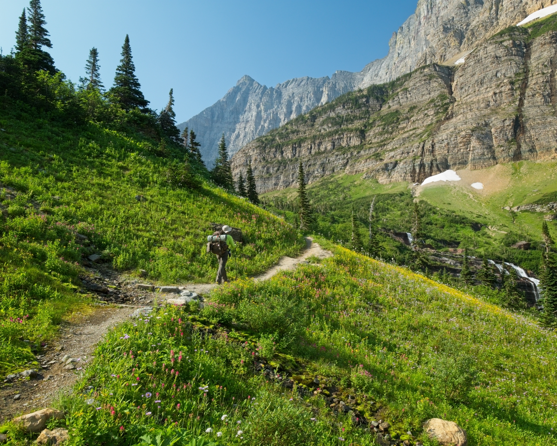
The Piegan Pass Trail climbs gradually through cool, shaded woods and thick thimbleberries. We pass a construction area for a new campsite, which is exciting! There aren’t any backcountry campsites on the trails near Many Glacier and it would be wonderful to have the option to camp away from the noise and crowds. Further up the trail, the forest is interspersed with meadows full of swaying wildflowers and long grass. As we wander through the meadows we discover that they are also full of stinging nettle; after a few painful encounters, I hold my hands over my head in surrender and avoid touching any of the plants.


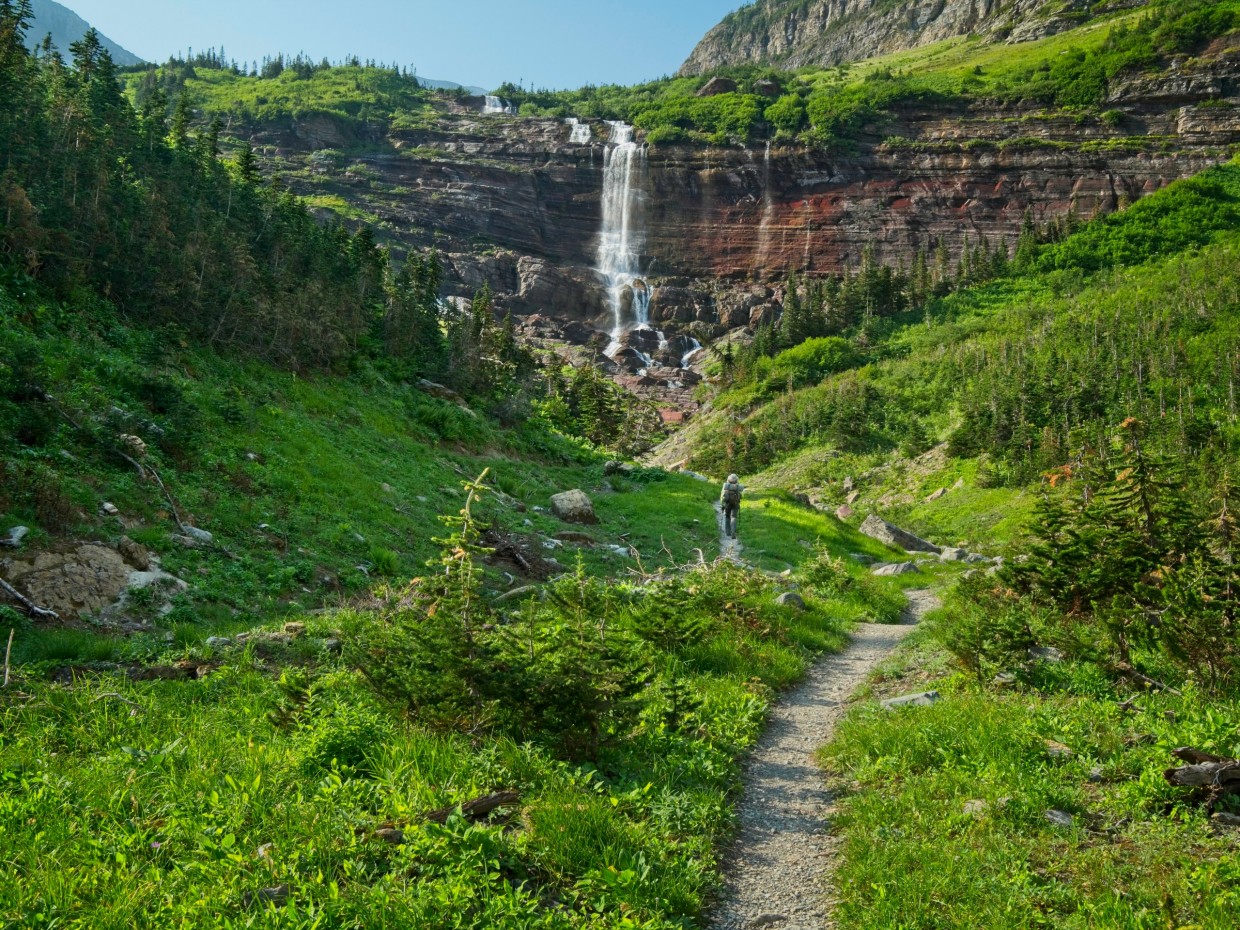
As we climb higher, the trees grow shorter and in smaller groves. We wind through a rocky valley, cross a gurgling creek, and then spot a magnificent waterfall a little ways up the valley. Excited, we hurry toward it, although I stop every few hundred feet to snap photo after photo of the waterfall, the trees, and the cliffs. The approach to the waterfall is one of the most scenic sections of hiking I’ve ever done. The brilliant green grass and trees lead up to a dark red line of cliffs over which the series of waterfalls crash down. At the bottom of the lowest falls, the water impacts boulders and atomizes into a fine mist. I’m surprised that we haven’t seen any other day hikers up here; this hike is easily just as impressive as the trail to Iceberg Lake or the Ptarmigan Tunnel!

After relaxing at the foot of the waterfall for a few minutes, Steve and I continue on. The trail begins a series of switchbacks that continue for quite some time, steadily climbing above the trees and into vast alpine meadows. Like most of the other mornings so far, the air is cool and a light breeze rustles through the grass. We pass small bunches of blanket flowers and bouquets of explorer’s gentian, all beautiful in the bright morning sun.


As we follow the trail higher up into the hills we notice a curious feature: long, alternating lines of rock and grass stretch horizontally across the slopes, like some sort of terraced garden. How do they form? Is this some sort of erosion pattern from the melting snow? Or is the wind the sculptor? With no answers to be had, we continue hiking. I enjoy the wide open landscape; as any of you regular readers will know, a big alpine meadow is one of my favorite places to be.
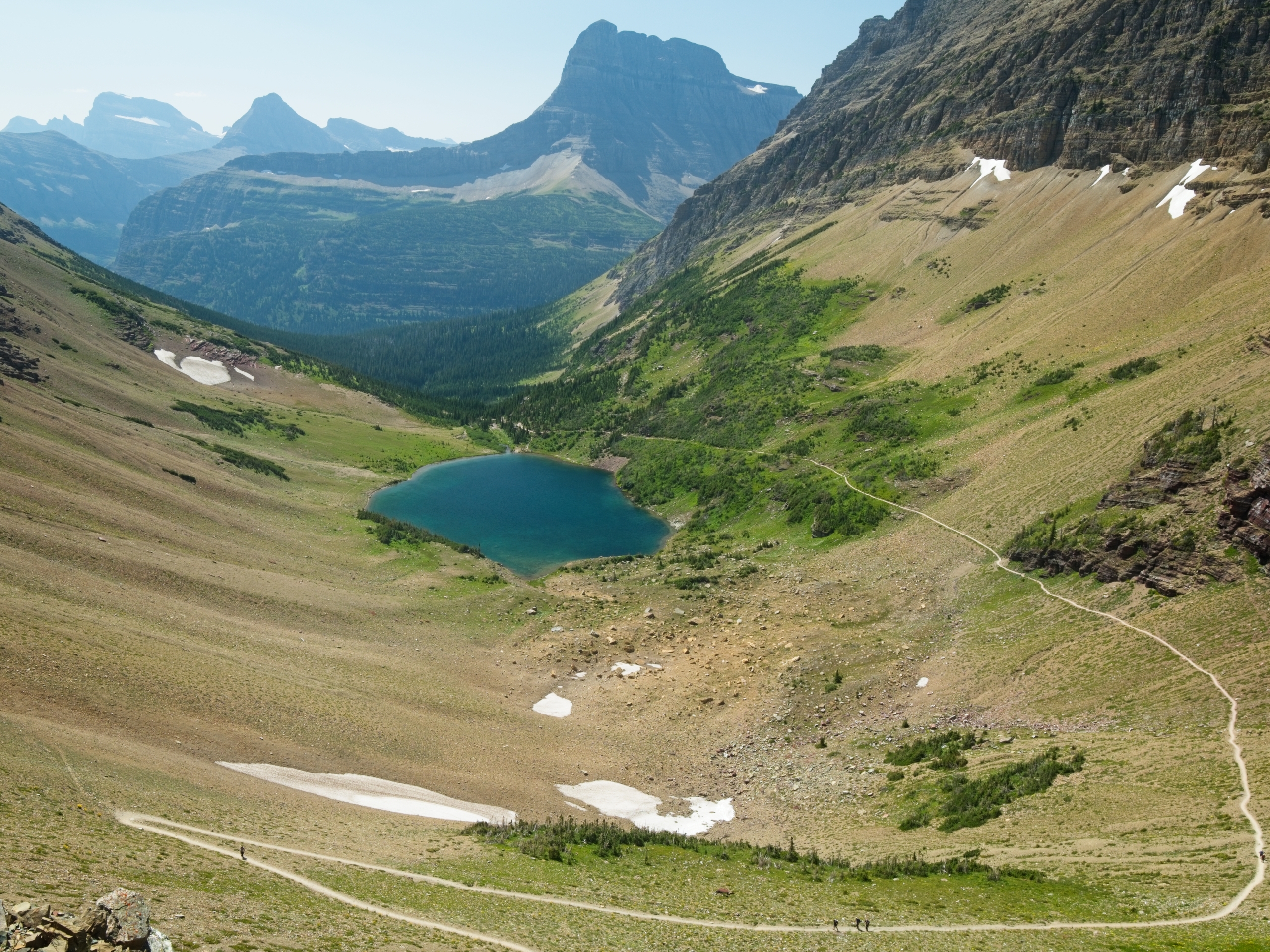
After following switchbacks through the meadows we reach rockier terrain below a band of cliffs. The trail zig-zags through the talus below the cliffs and then cuts along the cliff in a long diagonal line. Past the wall, we hike through more talus switchbacks interspersed with spongy grass. From here, the view down the valley toward Many Glacier is spectacular!


We soon reach the pass and take a break to eat lunch and rest. The views are nice and I appreciate the break, although the stiff breeze whipping across the saddle is a bit chilly. Steve and I chat with a few other hikers that are passing through as well as a pair of gentlemen that are also enjoying lunch here. Once we’ve eaten and rested, we continue down the trail toward the Siyeh Pass Trail and the Going to the Sun Road.
Like many of the afternoons we’ve experienced on this trip, we spend the next few hours in a hot, dusty descent. The trail switches back a few times below the pass and then cuts across the slopes below Piegan Pass in a long, straight diagonal line. We enjoy some nice views of the Piegan Glacier and the long, deep valley below as we stroll along the hillside. A few snowfields stretch across the path, adding some snow and ice to the otherwise dry descent.


Once we’ve contoured around the entire cliff the landscape grows a little more lush; wildflowers again line the trail and pine trees provide some shade from the afternoon sun. We soon reach the Siyeh Pass Trail and retrace our steps from the Siyeh Pass Loop hike we did a few days ago; the wildflowers are still amazing, but the downhill slope is punishing. Besides the pretty flowers, the highlight of the afternoon is spotting our first ptarmigan! We spent most of yesterday on the Ptarmigan Trail and have been wondering where the ptarmigans are. Or perhaps it’s a grouse… difficult to say.


By the time we reach the bottom of the hill, some 3000′ feet lower, my feet and knees ache. We cross another bouncy suspension bridge and find our campsite, the Reynold’s Creek Site, immediately on the other side of the creek. It’s been a long hike – 15 miles today, longer than all of our other days – but we’ve made good time; it’s only 3:30! We unpack our things and then spend the afternoon relaxing. It’s a bit hot in the tent, so we wander down to the creek and take naps in the shade on some large, flat rocks.


After napping for a bit, we play cards on a stump near the campfire ring and then cook some dinner. The family from South Carolina that we ran into yesterday arrives at the campsite later in the evening, very tired from the long hike from Many Glacier. We chat for a while and then head to bed.
Gunsight Pass Trail
8 Aug | 19.1 mi | +5800 / -3700 ft | View on Map
The next day we get another early start and enjoy strolling through the forest on an easy, level trail. The path is occasionally overgrown with thimbleberries and other plants, but is mostly clear and makes for a pleasant walk. We pass a few meadows of willows and long grass but don’t see any moose or other big animals out grazing. It’s funny how some locations are teeming with wildlife right next to the trail and other, more remote areas appear empty; the animals are almost definitely out there, just hidden from view…
An hour or two into our morning walk, we get a few glimpses of the massive Jackson and Blackfoot glaciers across the valley. It’s been a week or so since we last got a look at them while driving the Going to the Sun Road. Some smoke makes our view a little hazier today, but they’re impressive nonetheless!


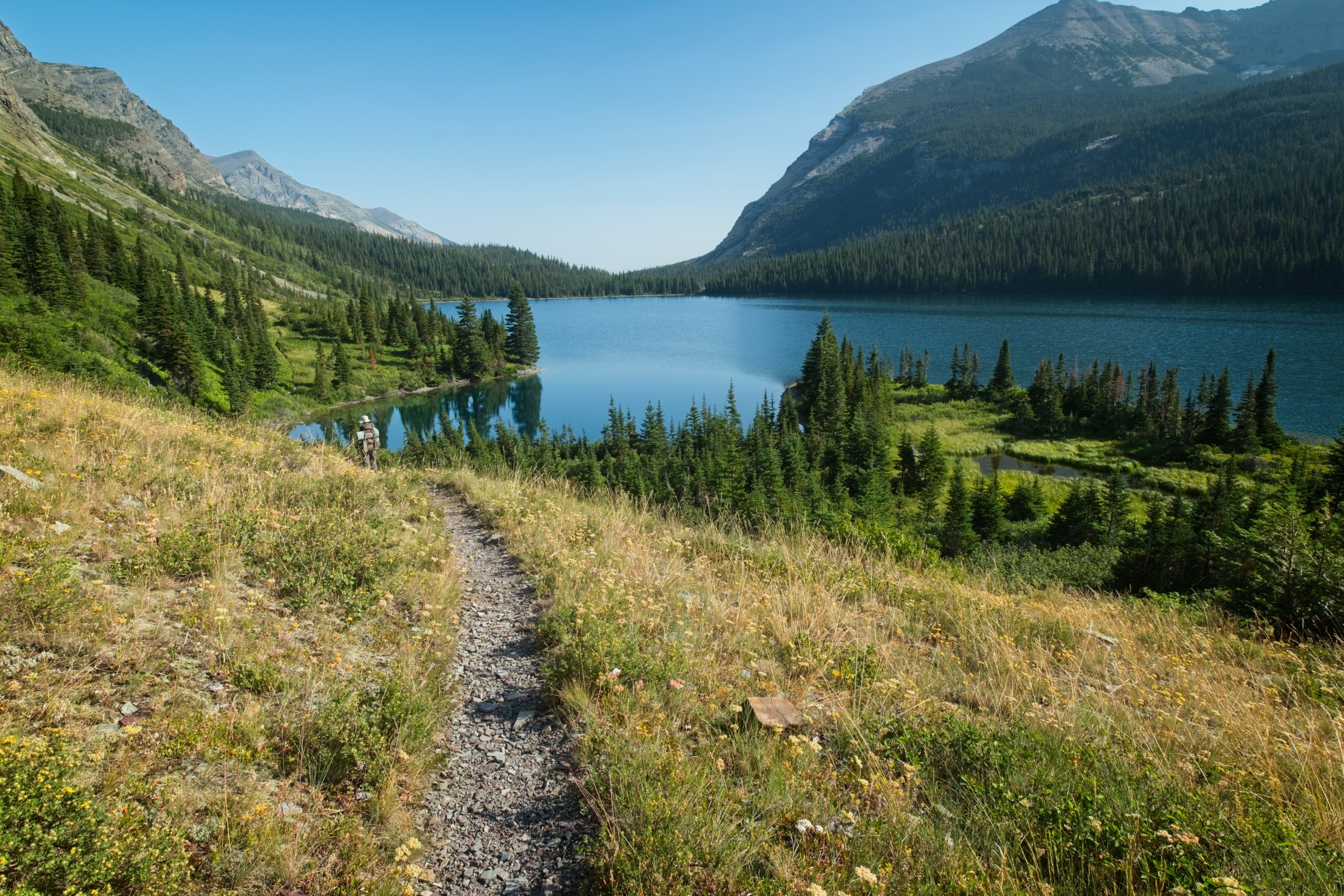
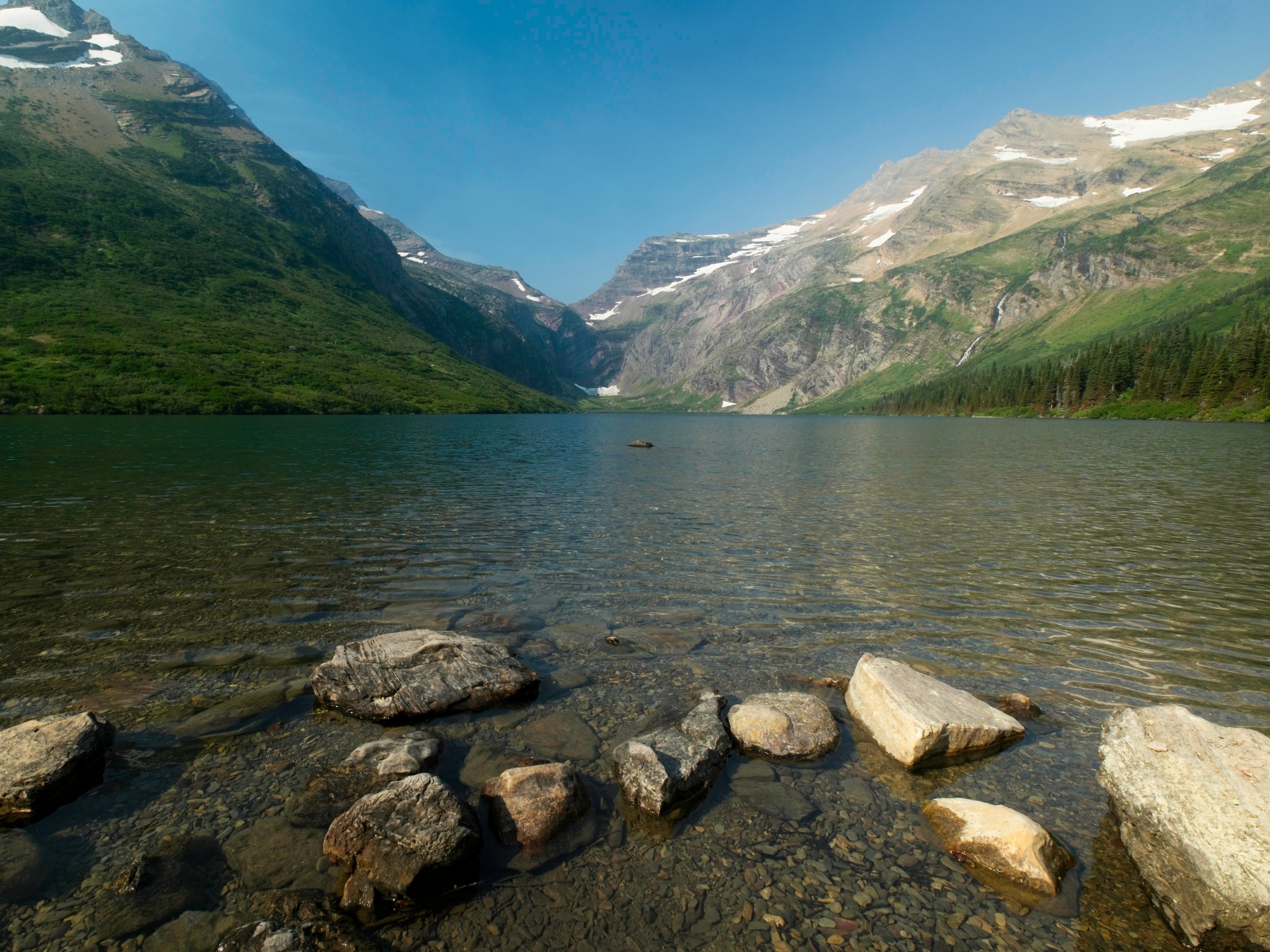
Further down the trail we reach Gunsight Lake, a long body of water with huge cliff walls at the far end. Steve and I are running low on water, so we find a small beach where we can refill our bottles and take in the scenery. The name of the lake comes from the pass above those cliffs, a smooth notch that sort of resembles a gun sight. Then again, most passes look a bit like a gun sight, so I’m not sure what makes this one name-worthy.
After a short break, we continue along the path, cross a suspension bridge that spans the outlet and then trek through tall bushes as the trail climbs the slope beside the lake. The trail remains overgrown for a while — maybe four or five very long switchbacks — but then breaks free of the vegetation into more open, rockier terrain. We meet several groups of day hikers on our way up; many of them are hiking all the way from the Jackson Overlook to the Lake McDonald Lodge, the distance we’re covering today and tomorrow! At one of the switchbacks we pass two goats nibbling on the brush. Like many of the other animals we’ve encountered in the backcountry, they’re not very afraid of us and don’t move as we walk by. A little further up the trail we also spot a hoary marmot, a colorful rodent about the size of a large house cat. I’ve never seen a marmot quite so colorful; most of the ones I’ve come across in the Sierra Nevada are entirely grey.


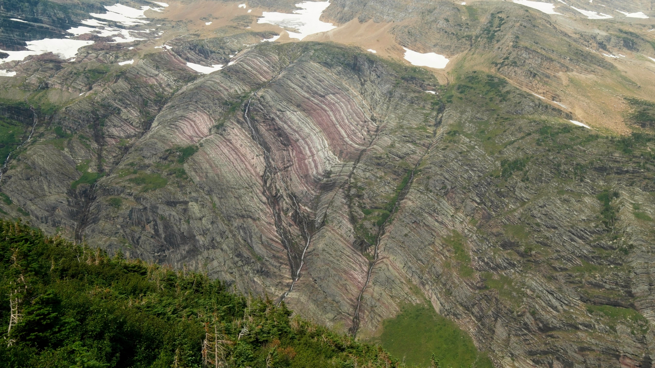
Across the valley, a long stretch of colorful, striated cliffs catches my eye. The layers are tilted, not at all parallel to the ground (or orthogonal to the local gravity field, if you want to get nerdy), a visual reminder that the ground we’re standing on is part of a huge, malleable tectonic plate. Half a dozen cascades crisscross the surface, interrupting the clean, parallel bands. It’s a cool view, and I snap several photos from different vantage points as we climb.
Looking back down the valley toward the foot of Gunsight Lake, a smokey haze hangs in the air, making the distant peaks look like ghosts. Although I’m a bit disappointed with the murkiness, I am thankful that the smoke isn’t thick enough to smell or affect our breathing. The scenery that isn’t obscured by the smoke is still incredible! As we approach the pass, we step across cascade after cascade and admire several patches of wildflowers. It’s like we’ve traveled back in time a few months by climbing a few thousand feet; it’s summer down by the lake, but spring up here.


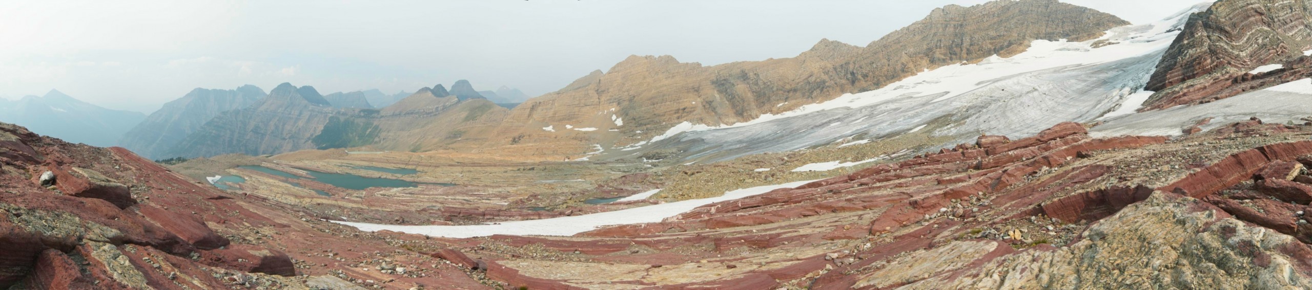
We soon reach Gunsight Pass and take a break to eat lunch and stare out across the next valley we’ll be traveling through. The trail zig-zags down the slope below us to the shore of Lake Ellen Wilson, a dark blue body of water surrounded by steep mountainsides. There’s a campsite down there, but we have a bit farther to go, although not for lack of trying. I attempted to adjust our itinerary when we passed through Many Glacier, but all of the walk-up permits for the Ellen Wilson campsite were taken.


After eating lunch and relaxing for a bit, we put our packs back on and speed down the switchbacks toward Lake Ellen Wilson. The trail doesn’t quite reach the shore but stays 30 or 40 feet above the lake. We cross a ferocious creek right below a waterfall and then begin a gradual uphill climb away from the water. The landscape is spectacular with lots of the sweet-smelling bear grass and another waterfall along the way!


However, for all the beautiful flowers and waterfalls, there is very little shade and the afternoon heat is a bit oppressive. To further accentuate the heat, the trail soon departs the grassy, wildflower-strewn slopes of the lake and enters a rocky, barren landscape below Lincoln Pass. With the smokey haze and a number of sun-bleached dead trees, it really is a desolate spot! Thankfully, the desolation is short-lived. As we climb the final few hundred feet to Lincoln Pass, the grass and pine trees return. We even spot a shaggy billy goat grazing on the hillside.


From the pass, a short but steep descent delivers us to the Sperry Campground. For the first time, we’ve beaten all the other hikers and have our pick of sites! Steve and I examine each one and choose our favorite. It’s a nice sandy square surrounded by rocks with a marvelous view of of Lake McDonald.
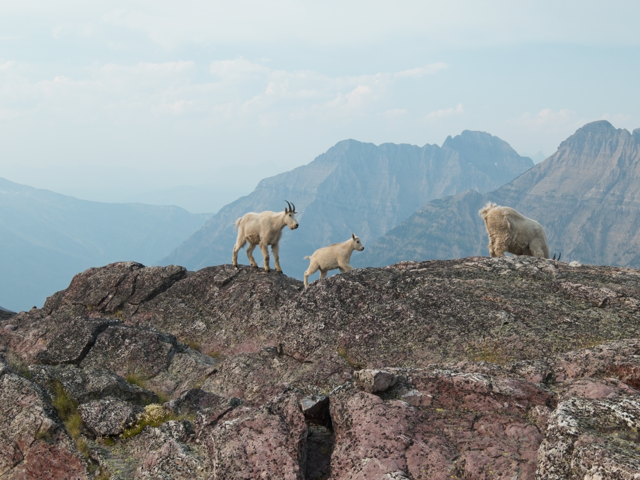
As we settle into the site, we’re on high alert for mountain goats. A ranger at Many Glacier warned us that the goats here (and at Lake Ellen Wilson) have been nibbling on people’s gear: backpacks, tents, trekking poles; you name it, they’ll chew on it. Her warnings are particularly memorable because she spent a full minute describing how she would skewer and roast any goat that dared put a hole in her tent… Only a few minutes later, a billy goat comes slowly wandering by, looking for some salty goodness to munch on. We clap our hands and yell a bit and he wanders off.
Several hikers we’ve met during the past week have recommended that we hike a nearby spur trail up to the Sperry Glacier. As it’s only mid afternoon, we have plenty of time to head up there and return before dark! Steve decides to relax at camp rather than climb the steep trail in the afternoon heat. I want to make a run for it, though, so I grab the gear I’ll need — water bottles and purification supplies, some snacks, a jacket, my photography equipment — and then head down the trail. I do enjoy a nice relaxing afternoon; it’s been fun to swim and lounge around at the various lakes we’ve camped beside. But I also enjoy pushing my limits and the heart-racing challenge of covering a lot of miles. To avoid pushing myself too far, I set a turn around time: basically, halfway between now and one hour before sunset. I know I’ll want to keep pushing (just a little further!) and a concrete deadline is the best way I know to reign in my enthusiasm. I have absolutely no desire to be out alone (in grizzly country!) when it begins to get dark.
From the campground, I follow the trail past the Sperry Chalet, which is currently under construction. It burned down during a recent forest fire and is in the process of being rebuilt. The place is massive; it must house at least forty or fifty people! A little ways beyond the chalet I reach the Sperry Glacier Trail and almost immediately being climbing uphill. It’s much easier to race up the trail when my backpack weights five or ten pounds than when it weights 20 pounds!
I don’t take many pictures during the ascent; I’m determined to reach the glacier and I have a deadline. Plus, I’m focused on maintaining a fast pace while climbing the steep switchbacks. It’s a lot like a race; setting a pace that you can maintain for the entire distance requires a fair amount of mental effort. Once I’ve ascended the switchbacks, I hurry through a field of massive boulders and then reach a beautiful lake surrounded by large slabs of rock. I’m struck by how similar this landscape is to the Sierra High Route!
As I continue to ascend I notice that the top of the valley is ringed by cliffs. I have no idea how I’m going to get over that headwall, but the only way to find out is to press on. When I eventually reach the them I discover that a chute has been blown into the cliffs and a set of steep stairs constructed in the bottom. A sentinel-like mountain goat watches as I approach and meet, for the first time in several hours, a few other hikers. They’re mostly heading downhill, but one ranger tells me to hike to the very last lookout point; the views are best from there, he says!


I hurry up the chute and emerge into a strange but beautiful landscape. Rolling waves of solid rock interspersed with snow and ice stretch into the distance. A string of massive cairns (they’re as tall as I am!) catches my attention; these must be the guides to the glacier lookout point. I pass a small group of hikers relaxing near the first cairn and hurry out into the rocks and snow, heading from cairn to cairn. The rugged, uneven landscape makes the hiking a bit more difficult than on-trail travel, but I love it! Off-trail hiking at this altitude is the absolute best.


Thirty or forty minutes later, I reach what appears to be the last cairn and am rewarded with a great view of the Sperry Glacier. Although the size of the glacier is impressive, I’m a little sad to see just how huge it used to be. The landscape has clearly been carved by the ice. For example, the troughs between the waves of rock I’ve been trekking across run parallel to the ice flow. Below the glacier, long, thin lakes fill other trenches excavated by the glacier.
I’m feeling a bit light headed, probably because I just raced up a mountain for two hours, so I sit down and eat a bag of trail mix and drink a bottle of water. When my blood sugar returns to normal, I wander around and admire the rocks. When I look closely I can see tiny scratches in the slabs left by rocks embedded in the glacier. Some of the slabs are smooth, but others have interesting ripples or colorful striations in them. For what must be the thousandth time, I wish that I knew more about geology. Or that I had a geologist friend I could barrage with questions. I imagine this place is a geologist’s heaven!


I keep an eye on my watch while wandering around, but I made it up here quickly enough to afford a little sightseeing now. So, I take my time and wander through the rocks. Several families of goats pass by as I make my way back toward the trail. Like most of the other goats Steve and I have seen this week, these are not at all afraid of me. In fact, they seem more curious than afraid. I wonder if hikers feed them? I would hope not, but… they probably do.
By the time I’ve returned to the cliff stairs, all of the other people that were up here have left. It is getting a little late. I have plenty of daylight left to make it back to the Sperry Campground, but, with the chalet closed for construction, all the other hikers must have trekked up from Lake McDonald, a much longer walk. As I descend back down the trail, now at a more leisurely pace, I snap lots of photos of the scenery that I hurried by. One of the perks of camping nearby is the opportunity to see the scenery when the sun is a little lower in the sky and the light is a little warmer, which makes the photos way better!


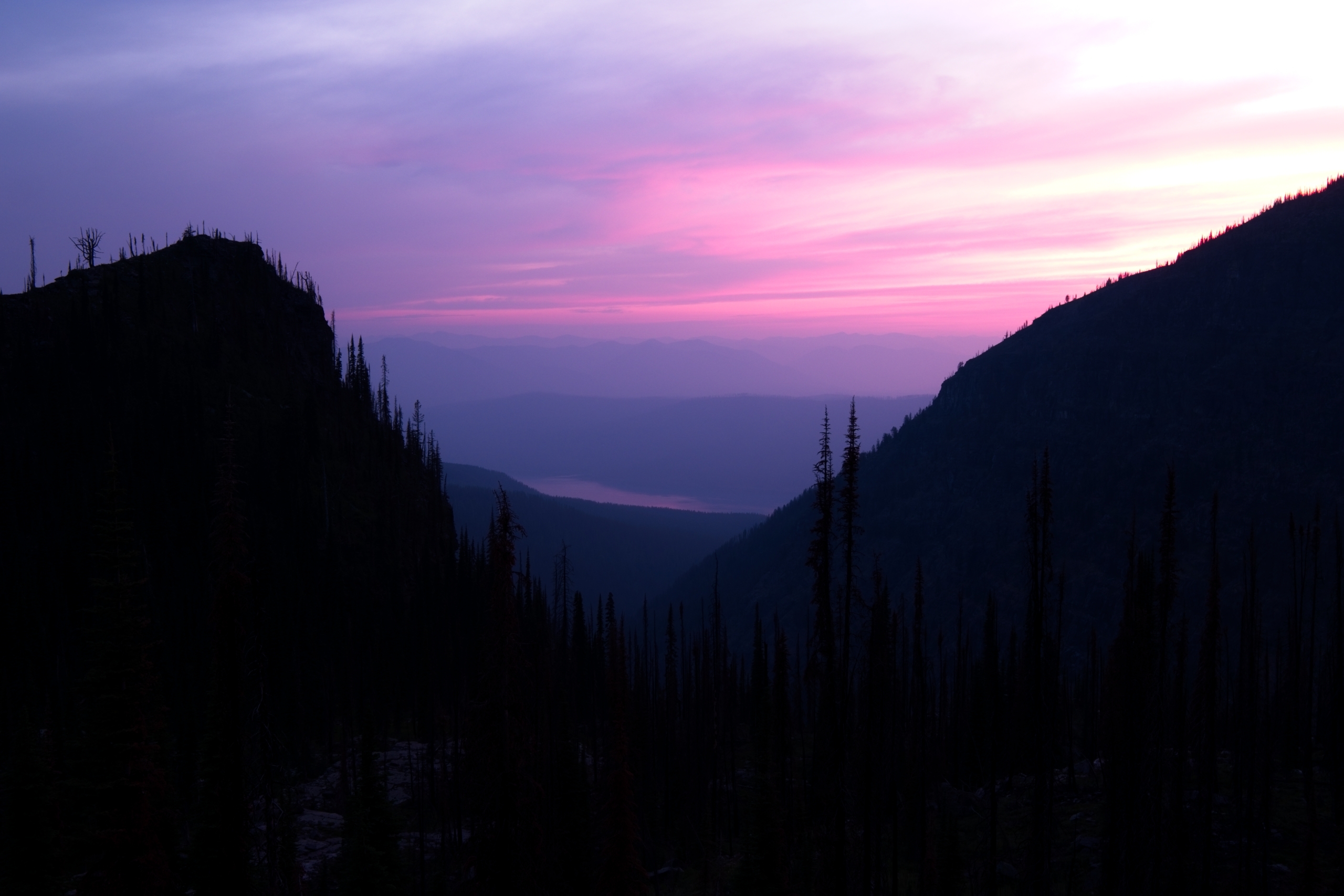
I return to camp at about 7:00, tired and hungry but very much satisfied with my choice to hike up to the glacier. The out-and-back trip was longer than I anticipated (7.2 miles with +/- 1700′ elevation change), but certainly one of the highlights of the trip for me. Steve has had a relaxing afternoon but is also ready for dinner. We head over to the food prep area, cook our meals, and then return to camp. Since we’re both around to keep the goats away, we can finally put up the tent and spend the rest of the evening watching the sun set.
Out of the Woods
9 Aug | 6.4 mi | +160 ft / -3600 ft| View on Map
The next morning, we crawl out of tent just after sunrise, eat a quick breakfast, and begin the final leg of our trip. Honestly, the last day of a backpacking trip is often my least favorite. You’re frequently descending a long, knee-jarring trail and you’re trading the tranquility of the backcountry for cars and crowds…
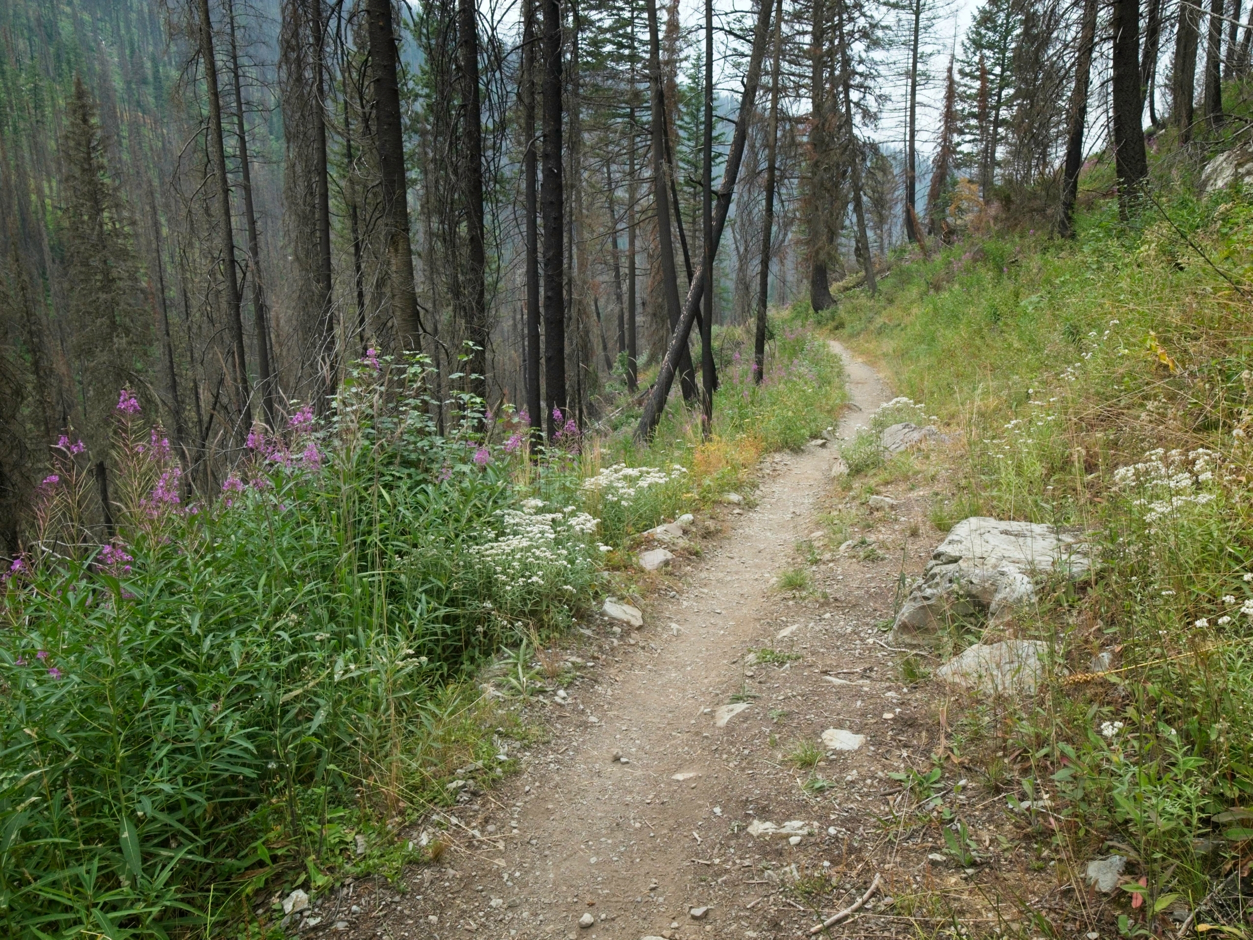
Thankfully, we get to enjoy the tranquil backcountry a while longer, although our route is basically just one long descent, which is hard on my feet and knees. Other than a small group of backpackers, we don’t see any people for several hours. Much of the landscape bears the scars of a recent wildfire; many of the trees are dead and those that still stand are charred. Perhaps my favorite part of the hike out is the cedar trees. Some are small but others tower over the trail. Their branches seem to defy gravity, lifting upward toward the sky, and the bark is soft and shaggy.
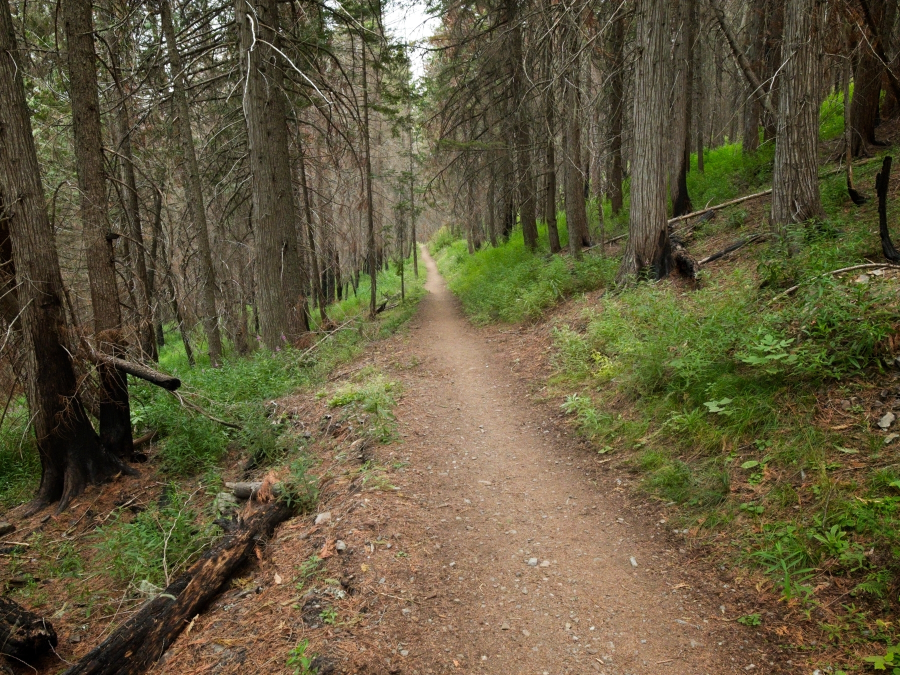
A little further down the trail we cross Snyder Creek and continue descending through increasingly dense forest. The trees grow taller and the signs of the wildfire are fewer and farther between. We also start running into day hikers that are out for a morning stroll. Compared to the trails near Many Glacier, however, there is practically nobody out.


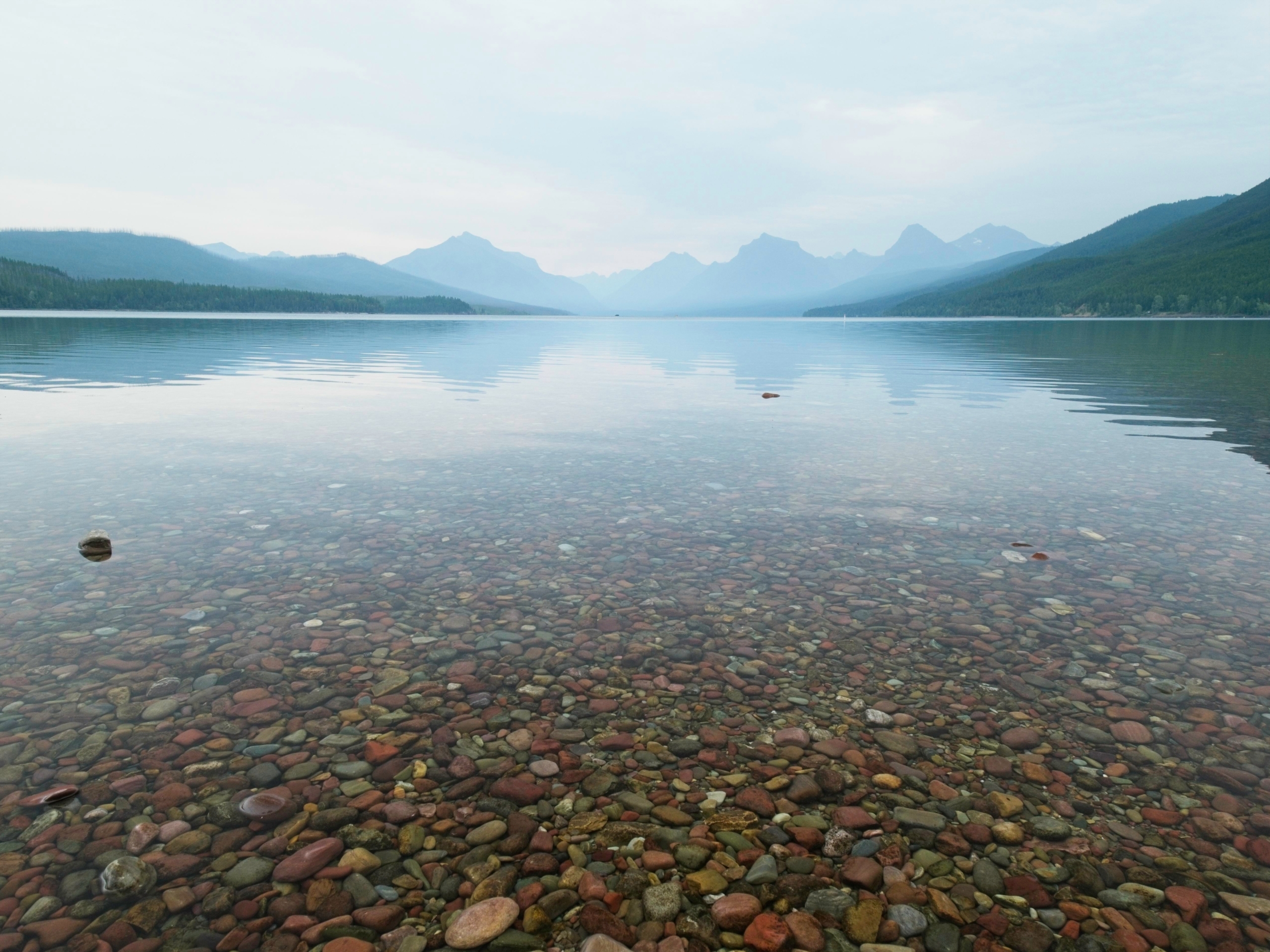
Only a few hours after leaving camp, we arrive at McDonald Lodge. We grab some refrigerated snacks from a camp store and then wait for a bus to Apgar Village. Once there, we relax by the lake for a while, skipping rocks and staring out across the water. The shuttle back to Hungry Horse won’t arrive for several hours, which gives us time to eat ice cream and visit the ranger station to ask them all of the questions we thought of while hiking. Once our curiosity is satisfied we meander back to the visitor center where the shuttle will arrive. It’s been a fantastic week on the trail, but Steve and I are both looking forward to a hot shower, clean clothes, and fresh food. As the bus rolls up, a light drizzle begins to fall; it’s time to go home.